 Old Cumbria Gazetteer
 |
 |
|
| Docker Nook, Longsleddale | ||
| Docker Nook | ||
| locality:- | Longsleddale | |
| civil parish:- | Longsleddale (formerly Westmorland) | |
| county:- | Cumbria | |
| locality type:- | buildings | |
| coordinates:- | NY50460131 | |
| 1Km square:- | NY5001 | |
| 10Km square:- | NY50 | |
|
|
||
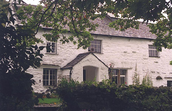 BJF16.jpg (taken 2.10.2004) 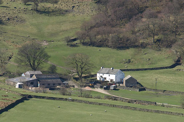 BSM20.jpg (taken 11.4.2010) |
||
|
|
||
| evidence:- | old map:- OS County Series (Wmd 27 15) placename:- Docker Nook |
|
| source data:- | Maps, County Series maps of Great Britain, scales 6 and 25
inches to 1 mile, published by the Ordnance Survey, Southampton,
Hampshire, from about 1863 to 1948.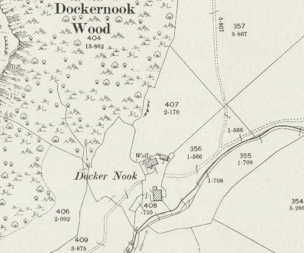 C5E018.jpg "Docker Nook" |
|
|
|
||
| evidence:- | census returns:- placename:- Docker Nook placename:- Dockernook |
|
|
|
||
 old parish registers (formerly ) old parish registers (formerly ) |
||
|
|
||
| evidence:- | old map:- Jefferys 1770 (Wmd) placename:- Docker Nook |
|
| source data:- | Map, 4 sheets, The County of Westmoreland, scale 1 inch to 1
mile, surveyed 1768, and engraved and published by Thomas
Jefferys, London, 1770.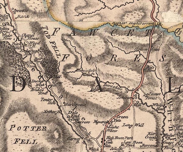 J5NY50SW.jpg "Docker Nook" circle, labelled in italic lowercase text; settlement, farm, house, or hamlet? item:- National Library of Scotland : EME.s.47 Image © National Library of Scotland |
|
|
|
||
| evidence:- | old map:- Cary 1789 (edn 1805) placename:- Docker Nook |
|
| source data:- | Map, uncoloured engraving, Westmoreland, scale about 2.5 miles
to 1 inch, by John Cary, London, 1789; edition 1805.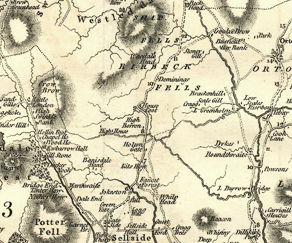 CY24NY50.jpg "Docker Nook" block/s, labelled in italic lowercase; house, or hamlet item:- JandMN : 129 Image © see bottom of page |
|
|
|
||
| evidence:- | old map:- Hall 1820 (Wmd) placename:- Docker Nook |
|
| source data:- | Map, hand coloured engraving, Westmoreland ie Westmorland, scale
about 14.5 miles to 1 inch, by Sidney Hall, London, 1820,
published by Samuel Leigh, 18 Strand, London, 1820-31. click to enlarge click to enlargeHA18.jpg "Docker Nook" circle, italic lowercase text; settlement item:- Armitt Library : 2008.14.58 Image © see bottom of page |
|
|
|
||
| evidence:- | old map:- Hodgson 1828 placename:- Docker Nook |
|
| source data:- | Map, hand coloured engraving, 4 sheets mounted together on linen and rolled, Plan
of the County of Westmorland, scale about 1.25 inches to 1 mile, by Thomas Hodgson,
engraved by W R Gardner, Harpur Street, London, published by Thomas Hodgson, Lancaster,
and perhaps by C Smith, 172 Strand, London,1828.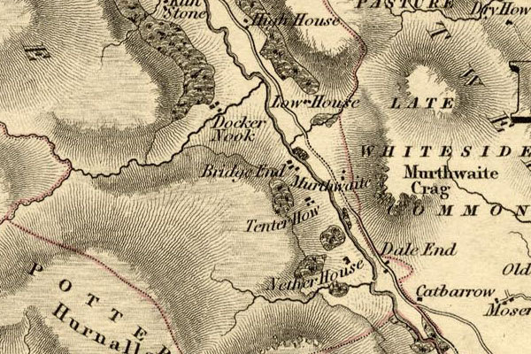 HDG6lsl1.jpg map courtesy of Mark Cropper "Docker Nook" item:- private collection : 371 Image © see bottom of page |
|
|
|
||
| Kendal Corn Rent Act 1836 |
||
|
|
||
| evidence:- | old map:- Ford 1839 map placename:- Docker Nook |
|
| source data:- | Map, uncoloured engraving, Map of the Lake District of
Cumberland, Westmoreland and Lancashire, scale about 3.5 miles
to 1 inch, published by Charles Thurnam, Carlisle, and by R
Groombridge, 5 Paternoster Row, London, 3rd edn 1843. FD02NY40.jpg "Docker Nook" item:- JandMN : 100.1 Image © see bottom of page |
|
|
|
||
| evidence:- | old map:- OS 1881-82 New Series (outline edition) placename:- Docker Nook |
|
| source data:- | Map, engraving, area north of Kendal, Westmorland, New Series
one inch map, outline edition, sheet 39, scale 1 inch to 1 mile,
published by the Ordnance Survey, Southampton, Hampshire,
1881-82.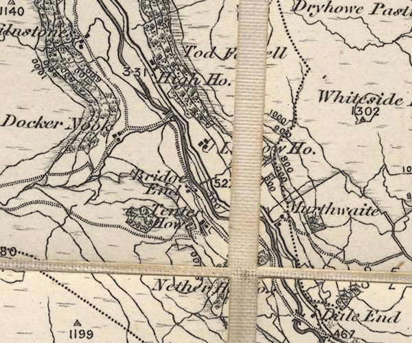 O21NY50A.jpg "Docker Nook" item:- JandMN : 61 Image © see bottom of page |
|
|
|
||
| evidence:- | records:- Curwen 1926 placename:- Dockernook item:- fence |
|
| source data:- | Records Relating to the Barony of Kendale, supplementary vol.3,
edited by John F Curwen, published by Titus Wilson and Son,
Kendal, Westmorland, 1926. CURWEN01.txt "1699/1700 January 12 : Roger Lickbarrow of Dockernook in Longsleddale, yeo., indicted for obstructing the common highway there leading from Kilne Stone to Dockernook Field, by raising a fence. Found not guilty on 11 October, 1700. K. Indictment Book, 1692-1724." |
|
|
|
||
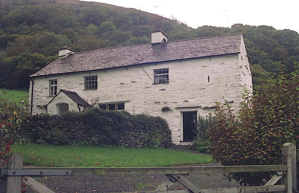
| evidence:- | descriptive text:- |
|
| source data:- | Royal Commission on Historical Monuments in England: 1936: Inventory of the Historical
Monuments in Westmorland: HMSO "[17th century, 2 storey, rubble walls, slate roofs] ... built late in the 17th or
early in the 18th century." |
|
|
|
||
| census records |
||
|
|
||
| directory entries |
||
|
|
||
| evidence:- | database:- Listed Buildings 2010 placename:- Docker Nook Farm |
|
| source data:- | courtesy of English Heritage "DOCKER NOOK FARMHOUSE AND ATTACHED OUTBUILDINGS / / / LONGSLEDDALE / SOUTH LAKELAND / CUMBRIA / II / 76405 / NY5047401319" |
|
|
|
||
| evidence:- | map:- OS Six Inch (1956) placename:- Docker Nook |
|
| source data:- | Map series, various editions with the national grid, scale about
6 inches to 1 mile, published by the Ordnance Survey,
Southampton, Hampshire, scale 1 to 10560 from 1950s to 1960s,
then 1 to 10000 from 1960s to 2000s, superseded by print on
demand from digital data. SINY5001.jpg "Docker Nook" |
|
|
|
||
| evidence:- | shepherds guide:- Wilson 1913 placename:- Docker Nook |
|
| source data:- | Book, New Shepherd's Guide for Cumberland, Westmorland, and
Lancashire, by Thomas Wilson, 1913.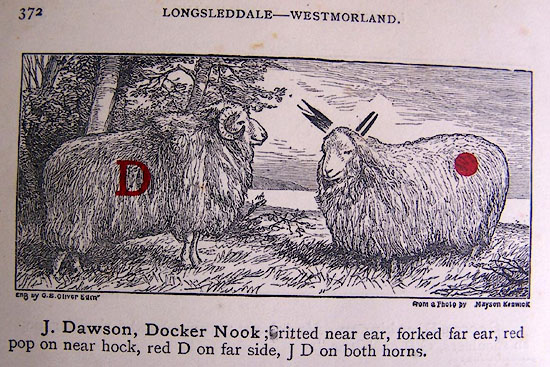 WL1p372a.jpg "J. Dawson, Docker Nook; ritted near ear, forked far ear, red pop on near hock, red D on far side, J D on both horns." item:- private collection : 329 Image © see bottom of page |
|
|
|
||
| evidence:- | shepherds guide:- Gate 1879 placename:- Docker Nook |
|
| source data:- | Book, New Shepherd's Guide for Cumberland, Westmoreland, and
Lancashire, published by Daniel Gate, Keswick, Cumberland, 1879.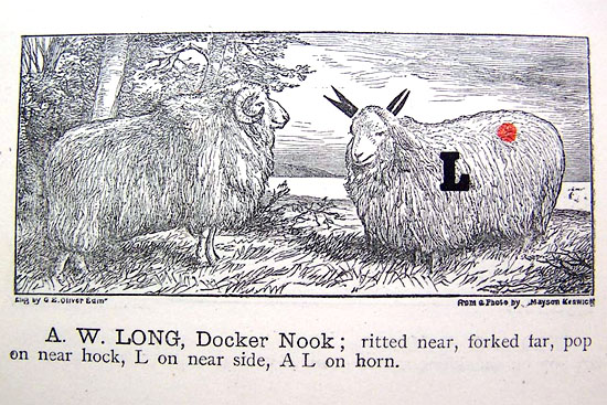 GT1p388b.jpg "A. W. LONG, Docker Nook; ritted near, forked far, pop on near hock, L on near side, AL on horn." item:- Kendal Library : 38 Image © see bottom of page |
|
|
|
||
| evidence:- | shepherds guide:- Hodgson 1849 placename:- Dockernook |
|
| source data:- | Book, Shepherd's Guide, or a Delineation of the Wool and Ear
Marks of the Different Stocks of Sheep, Lancashire, Cumberland,
and Westmorland, by William Hodgson, Normoss, Corney,
Cumberland, 1849.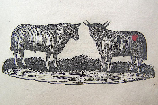 HG2p599c.jpg "JAMES ATKINSON, Dockernook." "Ritted near ear, forked far, a red pop on the near hock, G on the near side, JA on the horn." item:- Kendal Library : 39 Image © see bottom of page |
|
|
|
||
| evidence:- | shepherds guide:- Lamb 1937 placename:- Docker Nook |
|
| source data:- | Book, Lamb's Shepherds' Guide for Cumberland, Westmorland and
Lancashire, by R H Lamb, published by the Herald Printing Co,
Penrith, Cumberland, 1937.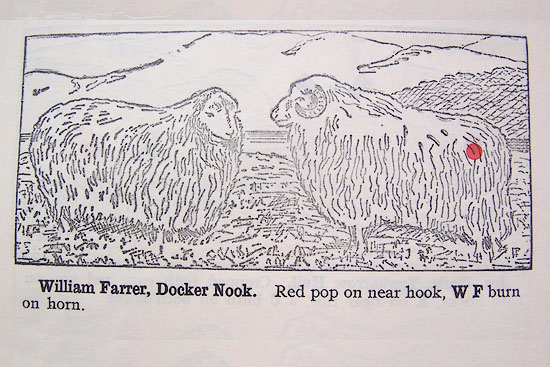 LM1p316b.jpg "William Farrer, Docker Nook. Red pop on near hook, W F burn on horn." item:- Kendal Library : 40 Image © see bottom of page |
|
|
|
||
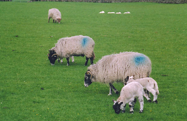 BIQ22.jpg Docker Nook Farm flock, swaledale sheep; blue pop on near hook. (taken 22.4.2004) |
||
|
|
||
 BJF15.jpg (taken 2.10.2004) 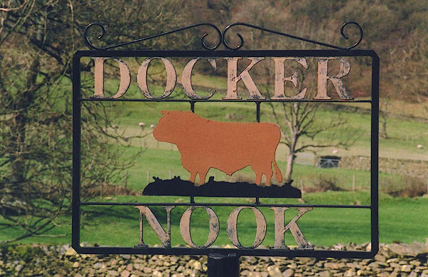 BIO16.jpg (taken 3.2004) |
||
|
|
||
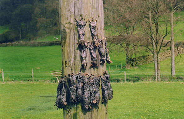 BIQ23.jpg Mole catcher's gibbet on an electricity supply pole, Docker Nook, Longsleddale, Westmorland, 22 April 2004. (taken 22.4.2004) |
||
|
|
||
| :- |
There is said to have been a potash kiln here. |
|
| : 2009: Archaeology Data Service |
||
|
|
||
 Lakes Guides menu.