 Old Cumbria Gazetteer
 |
 |
|
| Death's Head Hole, Lancashire | ||
| Death's Head Hole | ||
| site name:- | Gragareth | |
| site name:- | Leck Fell | |
| county:- | Lancashire | |
| locality type:- | pothole | |
| locality type:- | cave | |
| coordinates:- | SD668791 | |
| 1Km square:- | SD6679 | |
| 10Km square:- | SD67 | |
| altitude:- | 1120 feet | |
| altitude:- | 341m | |
| SummaryText:- | Explored by Yorkshire ramblers Club, 1889; further by the Gritstone Club, 1949 and 1968. | |
| SummaryText:- | Grade IV; permission from Council of Northern Caving Clubs. | |
| references:- | Balderston c1890 map Brook, D & Davies, G & Long, M H &Sutcliffe, J R: 1975: Northern Caves, vol.4 Whernside and Gragareth: Dalesman Books:: ISBN 0 85206 259 1 |
|
|
|
||
| evidence:- | descriptive text:- Balderston c1890 placename:- Death's Head Hole |
|
| source data:- | Book, Ingleton, Bygone and Present, by Robert R and Margaret
Balderston, published by Simpkin, Marshall and Co, London, and
by Edmndson and Co, 24 High Street, Skipton, Yorkshire, about
1890. goto source goto sourcepage 72:- "..." "Death's Head Hole." "Proceeding downwards [in Fenwick's Allotment], but diverging a trifle to the left, a second plot, enclosed by a circular railing, may be observed. Here is another chasm like the Fairies' Workshop, not so richly adorned, but still radiant in its embellishments, yet possessing a most remarkable configuration, indeed, that of the head and jaws of a human skeleton. The main shaft of the hole represents the mouth; a bridge-like bar of rock passes across the eastern verge, but is hollow below, so as to connect the chasm with a more shallow cavity beyond. The most peculiar feature, however, consists in a second bar-like bridge of limestone somewhat more slender than the first, spanning the secondary" goto sourcepage 73:- "rift in exactly the opposite direction to that assumed by the former, so as to meet the greater bar in the middle of its course and form part of the same trellice bridgework. In this manner two cavities, like those of the orbits in a skull are produced; and the result is wonderfully curious and fine. The mountain ash, ling, hawthorn, willow, shield ferns, polypody, ransoms, hartstongue, and ivy, were the decorations found here. The plummet descended one hundred and ninety-five feet, so that the total depth to the level of the ground around was fully two hundred." |
|
|
|
||
| evidence:- | old map:- Balderston c1890 map placename:- Death's Head Hole |
|
| source data:- | Map, the hills in the Ingleton area, probably by Robert R
Balderston, engraved by Goodall and Suddick, Leeds, West
Yorkshire, about 1890.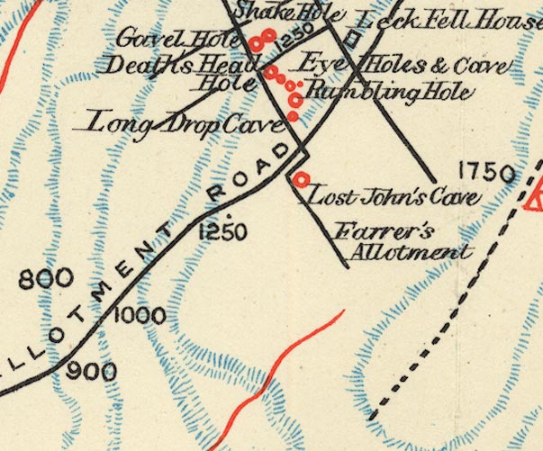 BS1SD67U.jpg "Death's Head Hole" item:- private collection : 27.1 Image © see bottom of page |
|
|
|
||
Lakes Guides menu.