 Old Cumbria Gazetteer
 |
 |
|
| Copper Plate Mines, Borrowdale | ||
| Copper Plate Mines | ||
| site name:- | High Close | |
| civil parish:- | Borrowdale (formerly Cumberland) | |
| county:- | Cumbria | |
| locality type:- | copper mine | |
| locality type:- | mine | |
| coordinates:- | NY246178 | |
| 1Km square:- | NY2417 | |
| 10Km square:- | NY21 | |
| references:- | Adams, John: 1988: Mines of the Lake District Fells: Dalesman Books (Lancaster, Lancashire)::
ISBN 0 85206 931 6 |
|
|
|
||
| evidence:- | old text:- Postlethwaite 1877 (3rd edn 1913) placename:- Copper Plate Mine item:- tools, mining; copper ore |
|
| source data:- | Book, Mines and Mining in the English Lake District, by John Postlethwaite, Keswick,
published by W H Moss and Sons, Whitehaven, Cumberland now Cumbria, 1877; published
1877-1913. goto source goto sourcepage 108:- "... AND COPPER PLATE MINES." "The Copper Plate Vein has been wrought extensively up the side of the mountain, at its base, and for some little distance across the valley. This mine was opened and named by the Germans under Hechstetter, in 1566; and judging from the extent of their excavations, a considerable quantity of ore must have been raised. In digging for the foundation of a house near" goto sourcepage 109:- "this mine, in 1871, a number of antiquated tools were found, which had no doubt belonged to the German miners." "This mine was also wrought about sixty years ago, and some ore was raised." |
|
|
|
||
| evidence:- | old map:- Postlethwaite 1877 (3rd edn 1913) placename:- Copper Plate Mine |
|
| source data:- | Map, uncoloured engraving, Map of the Lake District Mining Field, Westmorland, Cumberland,
Lancashire, scale about 5 miles to 1 inch, by John Postlethwaite, published by W H
Moss and Sons, 13 Lowther Street, Whitehaven, Cumberland, 1877 edn 1913.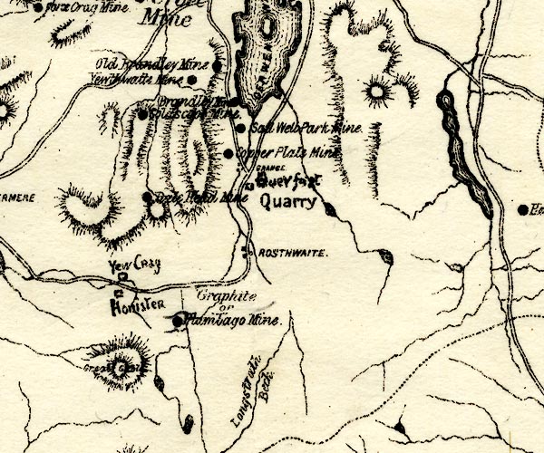 PST2NY21.jpg "Copper Plate Mine" mine symbol item:- JandMN : 162.2 Image © see bottom of page |
|
|
|
||
| evidence:- | visit log:- KDMRS 1979-82 placename:- Copper Plate Mine item:- copper pyrites |
|
| source data:- | Notes, log book of Geological Outings, mine plans, etc, Kendal
and District Mine Research Society, Kendal area, Cumbria, etc,
visits made 1979-82. Geological Outing of the Kendal and District Mine Research Society Log book page 52:- "DATE - 27/4/80 / MAP REF - 2475/1790 (NY21 1:25000) / LOCATION - MANESTY / NAME - COPPER PLATE MINE / TYPE OF SITE - MINE. / WORKING OR DISUSED - DISUSED. / PEOPLE IN PARTY [ ] / NOS. OF PHOTOS - 30 / SPECIMENS FOUND - PIECES OF COPPER PYRITES / COMMENTS - WARM DAY. THREE SMALL LEVELS ENTERABLE, ONE WITH DEEP WATER, BUT PASSABLE, ALL THREE ARE ONLY SHORT LEVELS BUT INTERESTING. SPOIL HEAPS VERY SMALL." item:- private collection : 82 Image © see bottom of page |
|
|
|
||
| evidence:- | mine drawing:- KDMRS 1979-82 placename:- Copper Plate Mine |
|
| source data:- | Geological Outing of the Kendal and District Mine Research Society to Copper Plate
Mines, Borrowdale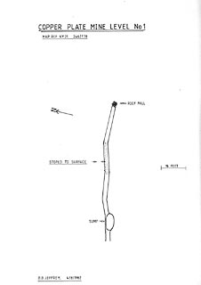 click to enlarge click to enlargeKMR12.jpg "COPPER PLATE MINE LEVEL No 1" 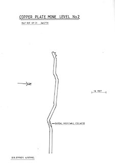 click to enlarge click to enlargeKMR13.jpg "COPPER PLATE MINE LEVEL No 2" 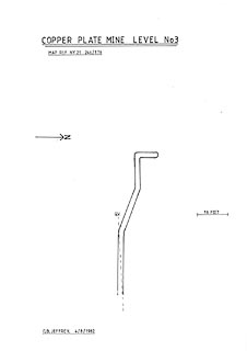 click to enlarge click to enlargeKMR14.jpg "COPPER PLATE MINE LEVEL No 3" 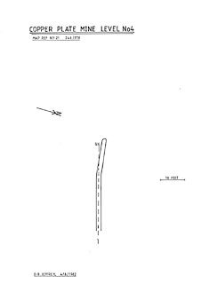 click to enlarge click to enlargeKMR15.jpg "COPPER PLATE MINE LEVEL No 4" item:- private collection : 82 Image © see bottom of page |
|
|
|
||
| :- |
First worked in 1566 by the Company of Mines Royal? and again in the 1800s. |
|
| Copper Plate Vein. |
||
| Adams, John: 1988: Mines of the Lake District Fells: Dalesman Books (Lancaster, Lancashire)::
ISBN 0 85206 931 6 |
||
|
|
||
Lakes Guides menu.