 Old Cumbria Gazetteer
 |
 |
|
| Chapel-le-Dale, North Yorkshire | ||
| Chapel-le-Dale | ||
| county:- | North Yorkshire | |
| locality type:- | buildings | |
| coordinates:- | SD737772 | |
| 1Km square:- | SD7377 | |
| 10Km square:- | SD77 | |
|
|
||
| evidence:- | descriptive text:- West 1778 (3rd edn 1784) placename:- Chapel in the Dale |
|
| source data:- | Guide book, A Guide to the Lakes, by Thomas West, published by
William Pennington, Kendal, Cumbria once Westmorland, and in
London, 1778 to 1821. goto source goto source3rd edn addenda, page 229:- "..." "Nigh the Chapel in the dale, on the north side of Ingleborough, I met with three caverns that are totally unlike any in this island, tho' caverns are common in all limestone countries. ..." |
|
|
|
||
| evidence:- | descriptive text:- West 1778 (11th edn 1821) placename:- Chapel in the Dale |
|
| source data:- | Guide book, A Guide to the Lakes, by Thomas West, published by
William Pennington, Kendal, Cumbria once Westmorland, and in
London, 1778 to 1821. goto source Tour to the Caves in the West Riding of Yorkshire, late 18th century Page 251:- "..." "[1] ... we took an evening walk, about a mile above the town [ingleton], to the slate quarries by the side of the river Wease, or Greta, which comes down out of Chapel-in-the-Dale, and joins the Kingsdale river at Ingleton. ..." "[1] If the tourist would proceed immediately to Chapel-in-the-Dale, he may go either below Breada-garth to Twisleton, and then turn up the vale to Chapel-in-the-dale; or, which is a nearer road, he may cross Kingsdale above Breada-garth, and ascend the mountain, pursuing a rough and not well-defined road, taking care to keep on the south-west side of a swamp, near a hill, or a heap of stones called a hurder, on the base of Whernside, and then to turn round the west corner of the mountain: afterwards he must turn his course easterly, along the base of the mountain, till he comes to some lanes, any of which will lead him, by some houses, down to the chapel, in the middle of the vale between Whernside and Ingleborough." goto sourcePage 253:- "..." "Early next morning we set off [from Ingleton] for Ingleton-fells, or Chapel-in-the-Dale, along the turnpike-road leading to Askrig and Richmond. ..." goto sourcePage 254:- "..." "... four miles from Ingleton, we turned off the turnpike-road to some houses near the chapel, where we left our horses. At first we imagined we had here met with an exception to the maxim of poet Butler, the author of Hudibras, viz.-" "A Jesuit never took in hand / To plant a church in barren land." "For the chapelry produceth neither wheat, oats, barley, pease, nor any other sort of grain; nor apples, pears, plums, cherries, nor any kind of fruit - a ripe gooseberry was a natural curiosity in the summer season, in most parts of the district; even their potatoes they have from other places. Yet though they were destitute of these productions, they were blessed with others as valuable, by way of compensation. They abound with excellent hay ground and pastures, and were rich in large flocks, and herds of cattle, which enabled them to purchase every conveniency of life. Having little intercourse with the luxurious, vicious, and designing part of mankind, they were temperate, substantial, sincere, and hospitable. We found an intelligent, agreeable, and entertain-" goto sourcePage 255:- "[entertain]ing companion and guide, in the curate, who served them also as school-master. As Dr. Goldsmith observes on a like occasion," "A man he was to all the country dear, / And passing rich with thirty pounds a year." |
|
|
|
||
| evidence:- | descriptive text:- Otley 1823 (8th edn 1849) placename:- Chapel-i'-th'-Dale |
|
| source data:- | Guide book, A Concise Description of the English Lakes, the
mountains in their vicinity, and the roads by which they may be
visited, with remarks on the mineralogy and geology of the
district, by Jonathan Otley, published by the author, Keswick,
Cumberland now Cumbria, by J Richardson, London, and by Arthur
Foster, Kirkby Lonsdale, Cumbria, 1823; published 1823-49,
latterly as the Descriptive Guide to the English Lakes. goto source Page 199:- "..." "THE CHAPEL-I'-TH'-DALE is 80 yards below Hurtle Pot. This church in the wilderness is a very humble structure, and its situation is so beautifully described by the erudite author of 'The Doctor' - now known," goto sourcePage 200:- "as it was always surmised, to be Dr. Southey - that we cannot help quoting him:- 'A hermit who could wish his grave to be as quiet as his cell, could find no better resting-place. On three sides there was an irregular low stone wall, rather to mark the limits of the sacred ground, than to enclose it; on the fourth it was bounded by a brook, whose waters proceed by a subterranean channel from Weathercote Cave. Two or three alders and rowan trees hung over the brook, and shed their leaves and seeds into the stream. Some bushy hazels grew at intervals along the lines of the walls, and a few ash trees as the wind had sown them. To the east and west some fields adjoined it, in that state of half-cultivation which gives a human character to solitude; to the south, on the other side of the brook, the common, with its limestone rocks peering everywhere above ground, extended to the foot of Ingleborough. A craggy hill, feathered with birch, sheltered it from the north. The turf was as soft and fine as that of the adjoining hills; it was seldom broken, so scanty was the population to which it was appropriated; scarcely a thistle or a nettle deformed it, and a few tomb-stones which had been placed there, were now themselves half buried. The sheep came over the wall when they listed, and sometimes took shelter in the porch from the storm. Their voices, and the cry of the kite wheeling above, were the only sounds which were heard there, except when the single bell, which hung in its niche over the entrance, tinkled for service on the Sabbath-day, or, with a slower tongue, gave notice that one of the children of the soil was returning to the earth from whence he sprung.'" |
|
|
|
||
| evidence:- | old map:- Ford 1839 map placename:- Chapel le Dale |
|
| source data:- | Map, uncoloured engraving, Map of the Lake District of
Cumberland, Westmoreland and Lancashire, scale about 3.5 miles
to 1 inch, published by Charles Thurnam, Carlisle, and by R
Groombridge, 5 Paternoster Row, London, 3rd edn 1843.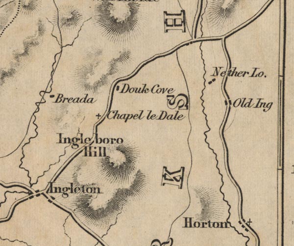 FD02SD77.jpg "Chapel le Dale" item:- JandMN : 100.1 Image © see bottom of page |
|
|
|
||
Lakes Guides menu.