 Old Cumbria Gazetteer
 |
 |
|
||||||||||||||||||||||||
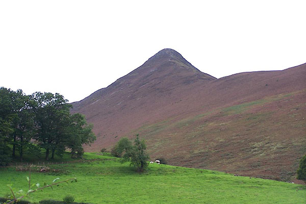
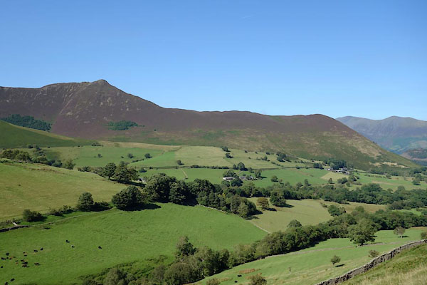
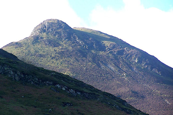
| Causey Pike, Above Derwent | ||||||||||||||||||||||||||
| Causey Pike | ||||||||||||||||||||||||||
| civil parish:- | Above Derwent (formerly Cumberland) | |||||||||||||||||||||||||
| county:- | Cumbria | |||||||||||||||||||||||||
| locality type:- | hill | |||||||||||||||||||||||||
| coordinates:- | NY21872085 | |||||||||||||||||||||||||
| 1Km square:- | NY2120 | |||||||||||||||||||||||||
| 10Km square:- | NY22 | |||||||||||||||||||||||||
| altitude:- | 2090 feet | |||||||||||||||||||||||||
| altitude:- | 637m | |||||||||||||||||||||||||
|
|
||||||||||||||||||||||||||
 BMR74.jpg (taken 22.9.2006) 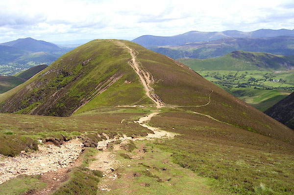 BPJ45.jpg (taken 23.6.2008) |
||||||||||||||||||||||||||
|
|
||||||||||||||||||||||||||
| evidence:- | old map:- OS County Series (Cmd 63 12) placename:- Causey Pike |
|||||||||||||||||||||||||
| source data:- | Maps, County Series maps of Great Britain, scales 6 and 25
inches to 1 mile, published by the Ordnance Survey, Southampton,
Hampshire, from about 1863 to 1948. |
|||||||||||||||||||||||||
|
|
||||||||||||||||||||||||||
| evidence:- | old map:- Otley 1818 placename:- Causey Pike |
|||||||||||||||||||||||||
| source data:- | Map, uncoloured engraving, The District of the Lakes,
Cumberland, Westmorland, and Lancashire, scale about 4 miles to
1 inch, by Jonathan Otley, 1818, engraved by J and G Menzies,
Edinburgh, Scotland, published by Jonathan Otley, Keswick,
Cumberland, et al, 1833.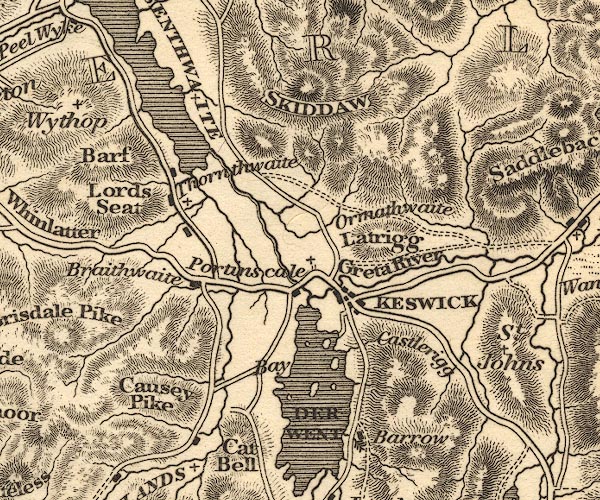 OT02NY22.jpg item:- JandMN : 48.1 Image © see bottom of page |
|||||||||||||||||||||||||
|
|
||||||||||||||||||||||||||
| evidence:- | outline view:- Otley 1823 (4th edn 1830) placename:- Causey Pike |
|||||||||||||||||||||||||
| source data:- | Print, engraving, outline view, Mountains South West of Derwentwater as seen from
Keswick, published by Jonathan Otley, Keswick, Cumberland et al, 1830.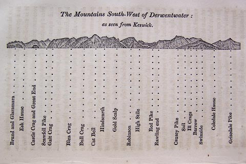 click to enlarge click to enlargeO75E06.jpg p.115 in A Concise Description of the English Lakes, by Jonathan Otley, 4th edition, 1830. "The Mountains South-West of Derwentwater: / as seen from Keswick." "Brund and Glaramara / Esk Hause / Castle Crag and Great End / Scawfell Pike / Gait Crag / Blea Crag / Bull Crag / Cat Bell / Hindscarth / Gold Scalp / Robinson / High Stile / Red Pike / Rawling end / Causey Pike / Sail / Ill Crags / Barrow / Swinside / Coledale Hause / Grisedale Pike" item:- Armitt Library : A1175.6 Image © see bottom of page |
|||||||||||||||||||||||||
|
|
||||||||||||||||||||||||||
| evidence:- | outline view:- Otley 1823 (8th edn 1849) placename:- Causey Pike |
|||||||||||||||||||||||||
| source data:- | Engraving, outline view of mountains, Derwent Water from Crow Park, drawn by T Binns,
engraved by O Jewitt, opposite p.10 of A Descriptive Guide of the English Lakes, by
Jonathan Otley, 8th edition, 1849.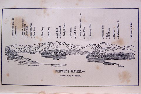 click to enlarge click to enlargeO80E06.jpg item:- Armitt Library : A1180.7 Image © see bottom of page |
|||||||||||||||||||||||||
|
|
||||||||||||||||||||||||||
| evidence:- | outline view:- Otley 1823 (8th edn 1849) placename:- Causey Pike |
|||||||||||||||||||||||||
| source data:- | Engraving, outline view of mountains, A Group of Mountains seen from Helvellyn, looking
towards the South West, drawn by T Binns, engraved by O Jewitt, opposite p.50 of A
Descriptive Guide of the English Lakes, by Jonathan Otley, 8th edition, 1849.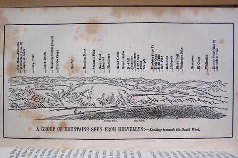 click to enlarge click to enlargeO80E17.jpg item:- Armitt Library : A1180.18 Image © see bottom of page |
|||||||||||||||||||||||||
|
|
||||||||||||||||||||||||||
| evidence:- | outline view:- Otley 1823 (5th edn 1834) |
|||||||||||||||||||||||||
| source data:- | Print, woodcut outline view, The Mountains South West of
Derwentwater, by Jonathan Otley, Keswick, Cumberland, 1830.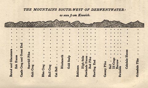 click to enlarge click to enlargeOT2E04.jpg Printed on p.21 of A Concise Description of the English Lakes, by Jonathan Otley, 5th edition, 1834. "THE MOUNTAINS SOUTH-WEST OF DERWENTWATER: as seen from Keswick" "Brund and Glaramara / Esk Hause / Castle Crag and Great End / Scawfell Pike / Gait Crag / Blea Crag / Bull Crag / Cat Bell / Hindscarth / Gold Scalp / Robinson / High Stile / Newlands Hause / Red Pike / Rawling End / Causey Pike / Sail / Ill Crags / Barrow / Swinside / Coledale Hause / Grisedale Pike" item:- JandMN : 48.5 Image © see bottom of page |
|||||||||||||||||||||||||
|
|
||||||||||||||||||||||||||
| evidence:- | outline view:- Otley 1823 (5th edn 1834) |
|||||||||||||||||||||||||
| source data:- | Print, woodcut outline view, A Group of Mountains, seen from
Helvellyn, by Jonathan Otley, Keswick, Cumberland, 1830.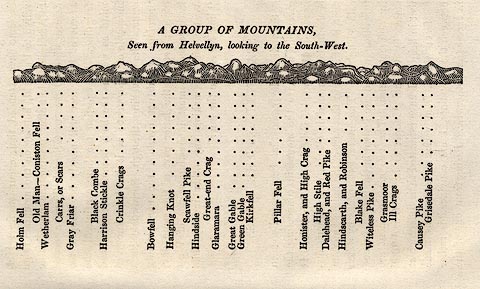 click to enlarge click to enlargeOT2E09.jpg Printed on p.63 of A Concise Description of the English Lakes, by Jonathan Otley, 5th edition, 1834. "A GROUP OF MOUNTAINS, Seen from Helvellyn, looking to the South-West." "Holm Fell / Old Man - Coniston Fell / Wetherlam / Carrs, or Scars / Gray Friar / Black Combe / Harrison Stickle / Crinkle Crags / Bowfell / Hanging Knot / Scawfell Pike / Hindside / Great-end Crag / Glaramara / Great Gable / Green Gable / Kirkfell / Pillar Fell / Honister, and High Crag / High Stile / Dalehead, and Red Pike / Hindscarth, and Robinson / Blake Fell / Witeless Pike / Grasmoor / Ill Crags / Causey Pike / Grisedale Pike" item:- JandMN : 48.10 Image © see bottom of page |
|||||||||||||||||||||||||
|
|
||||||||||||||||||||||||||
| evidence:- | descriptive text:- Ford 1839 (3rd edn 1843) placename:- Causey Pike item:- altitude, Causey Pike |
|||||||||||||||||||||||||
| source data:- | Guide book, A Description of Scenery in the Lake District, by
Rev William Ford, published by Charles Thurnam, Carlisle, by W
Edwards, 12 Ave Maria Lane, Charles Tilt, Fleet Street, William
Smith, 113 Fleet Street, London, by Currie and Bowman,
Newcastle, by Bancks and Co, Manchester, by Oliver and Boyd,
Edinburgh, and by Sinclair, Dumfries, 1839. goto source goto sourcePage 178:- "ELEVATION OF THE MOUNTAINS," "ACCORDING TO DIFFERENT AUTHORITIES."
|
|||||||||||||||||||||||||
|
|
||||||||||||||||||||||||||
| evidence:- | old map:- Ford 1839 map placename:- Causey Pike |
|||||||||||||||||||||||||
| source data:- | Map, uncoloured engraving, Map of the Lake District of
Cumberland, Westmoreland and Lancashire, scale about 3.5 miles
to 1 inch, published by Charles Thurnam, Carlisle, and by R
Groombridge, 5 Paternoster Row, London, 3rd edn 1843. FD02NY12.jpg "Causey Pike" Hill hachuring. item:- JandMN : 100.1 Image © see bottom of page |
|||||||||||||||||||||||||
|
|
||||||||||||||||||||||||||
| evidence:- | old map:- Garnett 1850s-60s H placename:- Causey Pike |
|||||||||||||||||||||||||
| source data:- | Map of the English Lakes, in Cumberland, Westmorland and
Lancashire, scale about 3.5 miles to 1 inch, published by John
Garnett, Windermere, Westmorland, 1850s-60s. GAR2NY22.jpg "Causey Pike" hill hachuring item:- JandMN : 82.1 Image © see bottom of page |
|||||||||||||||||||||||||
|
|
||||||||||||||||||||||||||
| evidence:- | outline view:- Martineau 1855 |
|||||||||||||||||||||||||
| source data:- | Print, engraving, outline view, Mountains seen from Applethwaite near Keswick, drawn
by L Aspland, engraved by W Banks, Edinburgh, published by John Garnett, Windermere,
Westmorland, and by Whittaker and Co, London, 1855.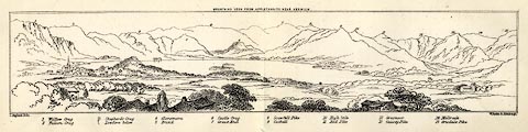 click to enlarge click to enlargeMNU114.jpg Plate, folded in opposite p.93 in A Complete Guide to the English Lakes, by Harriet Martineau. "MOUNTAINS SEEN FROM APPLETHWAITE NEAR KESWICK." "L Aspland Delt. / W Banks Sc Edinr." The view is captioned, numbers referring to mountains in the image:- "1 Wallow Crag, 2 Falcon Crag, 3 Shepherd's Crag / Lowdore below, 4 Glaramara, 5 Brund, 6 Castle Crag, 7 Great End, 8 Scawfell Pike, 9 Catbell, 10, High Stile, 11 Red Pike, 12 Grasmoor, 13 Causey Pike, 14 Melbreak, 15 Grisdale Pike" item:- Armitt Library : A1159.14 Image © see bottom of page |
|||||||||||||||||||||||||
|
|
||||||||||||||||||||||||||
| evidence:- | old text:- Martineau 1855 item:- altitude, Causey Pike |
|||||||||||||||||||||||||
| source data:- | Guide book, A Complete Guide to the English Lakes, by Harriet
Martineau, published by John Garnett, Windermere, Westmorland,
and by Whittaker and Co, London, 1855; published 1855-76. goto source Page 179:- "A TABLE OF THE HEIGHTS OF MOUNTAINS IN THE COUNTIES OF CUMBERLAND, WESTMORLAND, AND LANCASHIRE." "No. : Names of Mountains. : Counties. : Height in Feet above the Sea Level." "20 : Causey Pike : Cumberland : 2040" |
|||||||||||||||||||||||||
|
|
||||||||||||||||||||||||||
| evidence:- | old photograph:- Bell 1880s-1940s |
|||||||||||||||||||||||||
| source data:- | Photograph, black and white, Friar's Crag and Causey Pike, Derwent Water, Cumberland,
by Herbert Bell, Ambleside, Westmorland, 1890s.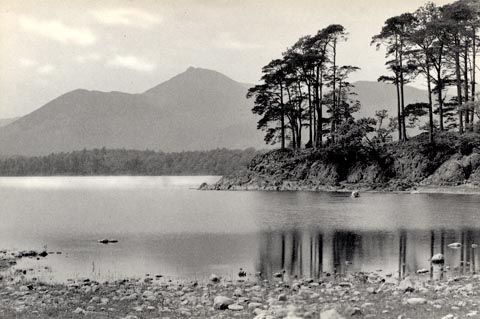 click to enlarge click to enlargeHB0482.jpg stamped at reverse:- "HERBERT BELL / Photographer / AMBLESIDE" item:- Armitt Library : ALPS141 Image © see bottom of page |
|||||||||||||||||||||||||
|
|
||||||||||||||||||||||||||
| evidence:- | old photograph:- Bell 1880s-1940s |
|||||||||||||||||||||||||
| source data:- | Photograph, black and white, Derwent Water and Causey Pike, Above Derwent, Cumberland,
by Herbert Bell, Ambleside, Westmorland, 1890s.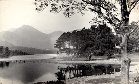 click to enlarge click to enlargeHB0478.jpg stamped at reverse:- "HERBERT BELL / Photographer / AMBLESIDE" item:- Armitt Library : ALPS137 Image © see bottom of page |
|||||||||||||||||||||||||
|
|
||||||||||||||||||||||||||
| evidence:- | old photograph:- Bell 1880s-1940s |
|||||||||||||||||||||||||
| source data:- | Photograph, b/w, Derwent Water and Causey Pike, Cumberland, by Herbert Bell, Ambleside,
Westmorland, 1890s?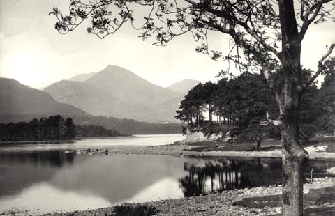 click to enlarge click to enlargeHB0282.jpg item:- Armitt Library : ALPS639 Image © see bottom of page |
|||||||||||||||||||||||||
|
|
||||||||||||||||||||||||||
| evidence:- | old postcard:- placename:- Causey Pike |
|||||||||||||||||||||||||
| source data:- | Postcard, colour photograph, Derwent Water and Causey Pike from Broomhill Point, Keswick,
Cumberland, published by Sanderson and Dixon, Ambleside, Westmorland, about 1959.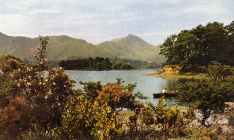 click to enlarge click to enlargePH0110.jpg printed at bottom:- "DERWE[ ] CAUSEY PIKE FROM BROOMHILL POINT, KESWICK" item:- JandMN : 976.2 Image © see bottom of page |
|||||||||||||||||||||||||
|
|
||||||||||||||||||||||||||
| evidence:- | outline view:- Barrow 1888 placename:- Causey Pike |
|||||||||||||||||||||||||
| source data:- | Outline view, engraving? Outline of Mountain Tops as seen from the Keswick Hotel,
sketched by John Barrow, published by Sampson Low, Marston, Searle, and Rivington,
St Dunstan's House, Fetter Lane, Fleet Street, London, 1888.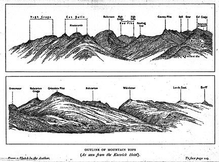 click to enlarge click to enlargeBRW1.jpg "... Causey Pike ..." item:- Kendal Library : 10.3 Image © see bottom of page |
|||||||||||||||||||||||||
|
|
||||||||||||||||||||||||||
| evidence:- | outline view:- Jenkinson 1875 placename:- Causey Pike |
|||||||||||||||||||||||||
| source data:- | Print, lithograph, outline view, Panoramic Sketches from Helvellyn, Westmorland, by
Edwin A Pettitt, London, published by Edward Stanford, 55 Charing Cross, London, 1875. click to enlarge click to enlargeJk01E1.jpg "... Causey Pike ..." item:- JandMN : 28.5 Image © see bottom of page |
|||||||||||||||||||||||||
|
|
||||||||||||||||||||||||||
| evidence:- | outline view:- Jenkinson 1875 placename:- Causey Pike |
|||||||||||||||||||||||||
| source data:- | Print, lithograph, outline view, Panoramic Sketches from Skiddaw, Cumberland, by Edwin
A Pettitt, London, published by Edward Stanford, 55 Charing Cross, London, 1875. click to enlarge click to enlargeJk01E2.jpg "... Causey Pike ..." item:- JandMN : 28.8 Image © see bottom of page |
|||||||||||||||||||||||||
|
|
||||||||||||||||||||||||||
| evidence:- | outline view:- Jenkinson 1875 placename:- Causey Pike |
|||||||||||||||||||||||||
| source data:- | Print, lithograph, outline view, Panoramic Sketches from Scawfell Pike, Cumberland,
by Edwin A Pettitt, London, published by Edward Stanford, 55 Charing Cross, London,
1875. click to enlarge click to enlargeJk01E3.jpg "... Causey Pike ..." item:- JandMN : 28.9 Image © see bottom of page |
|||||||||||||||||||||||||
|
|
||||||||||||||||||||||||||
| evidence:- | outline view:- Black 1856 (23rd edn 1900) placename:- Causey Pike |
|||||||||||||||||||||||||
| source data:- | Print, lithograph, Outline Views, Skiddaw and Derwent Water - Mountains as seen at
Lodore Hotel, and Mountains as seen at the Third Gate on Ascending Latrigg on the
Way to Skiddaw, by J Flintoft, Keswick, Cumberland, engraved by R Mason, Edinburgh,
Lothian, about 1900.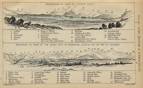 click to enlarge click to enlargeBC08E4.jpg "... 20 Causey Pike ..." item:- JandMN : 37.14 Image © see bottom of page |
|||||||||||||||||||||||||
|
|
||||||||||||||||||||||||||
| evidence:- | old painting:- placename:- Causey Pike |
|||||||||||||||||||||||||
| source data:- | Painting, oil on canvas, Catbells and Causey Pike, Derwentwater, Cumberland, by William
James Blacklock, 1854.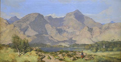 click to enlarge click to enlargePR0918.jpg This is a view of Catbells and Causey Pike beyond Derwent Water in the Lake District on a fine summer's day. Bright sunshine throws the shadows of the fells beyond the lake into sharp relief. In the middle distance to right of composition the church spire of St John's Church, Keswick can be seen rising from thick woodland in front of which sheep are grazing. In the foreground a sandy track leads towards the lake in the centre of the composition. A woman stands amongst clumps of flowering heather, her back towards the viewer, looking towards the church spire. This painting was exhibited at the Royal Academy in 1854. Blacklock is one of Cumbria's most important landscape painters. He painted the scenery of Cumbria, the Lake District and the Borders and particularly favoured remote areas. He painted these landscapes in his own uniquely precise style. The composition shows considerable artistic licence. Blacklock has altered components of the picture by bringing St John's Church in Keswick into view to make a more pleasing composition. Blacklock's unique painting style is very precise and has an almost three dimensional effect. labelled at reverse on stretcher:- "Cat Bells and Causey Pike, Derwentwater W J Blacklock Cumwhitton No 3 Carlisle" item:- Tullie House Museum : 1935.91.1 Image © Tullie House Museum |
|||||||||||||||||||||||||
|
|
||||||||||||||||||||||||||
| evidence:- | outline view:- Black 1841 (3rd edn 1846) placename:- Causey Pike |
|||||||||||||||||||||||||
| source data:- | Print, engraving, outline view, Mountains as seen at Lowdore Inn, and Mountains as
seen at the Third Gate on Ascending Latrigg on the Way to Skiddaw, by J Flintoft,
Keswick, Cumberland, engraved by R Mason, Edinburgh, Lothian, about 1846.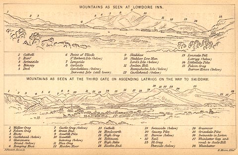 click to enlarge click to enlargeBC02E4.jpg "... 20 Causey Pike ..." item:- JandMN : 32.7 Image © see bottom of page |
|||||||||||||||||||||||||
|
|
||||||||||||||||||||||||||
| evidence:- | outline view:- Tattersall 1836 placename:- Causey Pike |
|||||||||||||||||||||||||
| source data:- | Print, engraving, Newlands Vale, from Robinson Fall, Cumberland, drawn by George Tattersall,
engraved by W F Topham, published by Sherwood and Co, Paternoster Row, London, about
1836.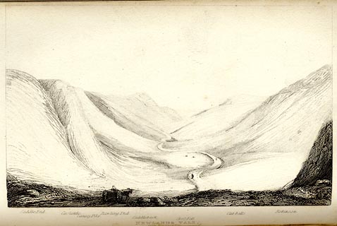 click to enlarge click to enlargeTAT129.jpg The print is captioned with mountain names and acts as an outline view. Tipped in opposite p.75 of The Lakes of England, by George Tattersall. printed at bottom:- "NEWLANDS VALE, / from Robinson Fall." printed at bottom left to right:- "Saddle End. / Caskettle. / Causey Pike. / Rawling End. / Saddleback. / Cross Fell. / Cat-bells. / Robinson." item:- Armitt Library : A1204.30 Image © see bottom of page |
|||||||||||||||||||||||||
|
|
||||||||||||||||||||||||||
 BZG56.jpg Causey Pike and Rowling End. (taken 6.9.2013) 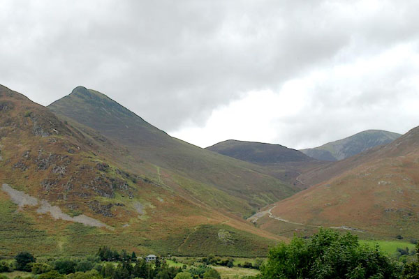 BRP43.jpg Looking up the Stonycroft Gill. (taken 25.9.2009) 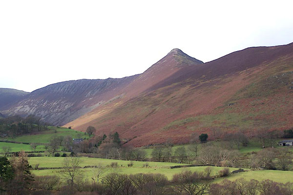 BOK50.jpg (taken 19.1.2008) |
||||||||||||||||||||||||||
|
|
||||||||||||||||||||||||||
 BNE21.jpg (taken 14.2.2007) 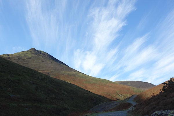 BZN91.jpg and clouds. (taken 24.10.2013) |
||||||||||||||||||||||||||
|
|
||||||||||||||||||||||||||
Lakes Guides menu.