 Old Cumbria Gazetteer
 |
 |
|
| Castle Howe, Tebay | ||
| Castle Howe | ||
| locality:- | Tebay | |
| civil parish:- | Tebay (formerly Westmorland) | |
| county:- | Cumbria | |
| locality type:- | motte and bailey | |
| locality type:- | castle | |
| coordinates:- | NY61350514 | |
| 1Km square:- | NY6105 | |
| 10Km square:- | NY60 | |
|
|
||
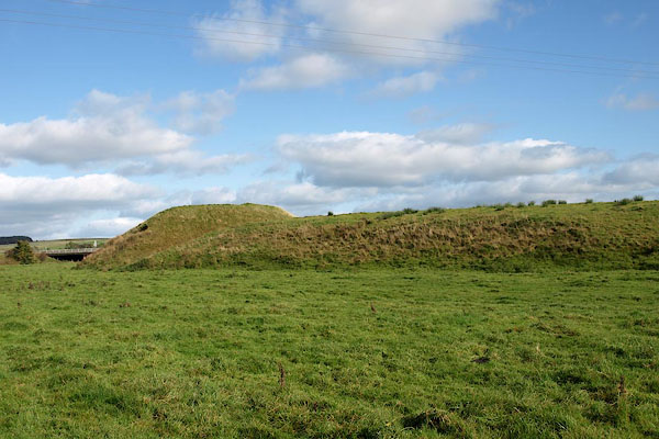 BRS89.jpg (taken 16.10.2009) |
||
|
|
||
| evidence:- | old map:- OS County Series (Wmd 28 8) placename:- Castle Howe |
|
| source data:- | Maps, County Series maps of Great Britain, scales 6 and 25
inches to 1 mile, published by the Ordnance Survey, Southampton,
Hampshire, from about 1863 to 1948. |
|
|
|
||
| evidence:- | old text:- Camden 1789 (Gough Additions) placename:- Castle How |
|
| source data:- | Book, Britannia, or A Chorographical Description of the Flourishing Kingdoms of England,
Scotland, and Ireland, by William Camden, 1586, translated from the 1607 Latin edition
by Richard Gough, published London, 1789. Page 156:- "..." "... Tebay ... near it a mount called Castle how, with a trench thrown up to check the inroads of the Scots; as was another of the same name at Greenholm; both which mounts commanded the two great roads. ..." |
|
|
|
||
| evidence:- | site plan:- Curwen 1913 placename:- Castle Howe |
|
| source data:- | Site plan, lithograph, Castle Howe, Tebay, Westmorland, scale about 1 to 3400, published
for the Cumberland and Westmorland Antiquarian and Archaeological Society by Titus
Wilson, Kendal, Westmorland, 1913.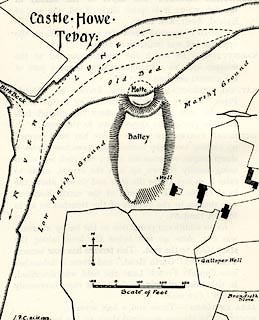 click to enlarge click to enlargeCW0107.jpg On p.32 of The Castles and Fortified Towers of Cumberland, Westmorland, and Lancashire North of the Sands, by John F Curwen. printed at upper left:- "Castle Howe / Tebay" item:- Armitt Library : A782.7 Image © see bottom of page |
|
|
|
||
| notes:- |
motte and bailey |
|
| Perriam, D R &Robinson, J: 1998: Medieval Fortified Buildings of Cumbria: CWAAS::
ISBN 1 873124 23 6 |
||
|
|
||
 Lakes Guides menu.