 Old Cumbria Gazetteer
 |
 |
|
| Casterton stone circle, Casterton | ||
| Casterton Stone Circle | ||
| Druid's Temple | ||
| civil parish:- | Casterton (formerly Westmorland) | |
| county:- | Cumbria | |
| locality type:- | stone circle | |
| coordinates:- | SD63927998 | |
| 1Km square:- | SD6379 | |
| 10Km square:- | SD67 | |
| altitude:- | 525 feet | |
| altitude:- | 160m | |
|
|
||
| evidence:- | site plan:- Historical Monuments 1936 |
|
| source data:- | Site plan, uncoloured lithograph, Stone Circle at Casterton, Casterton, Westmorland,
scale about 1 to 290, published by Royal Commission on Historical Monuments England,
London, 1936.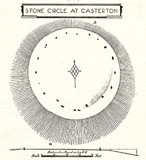 click to enlarge click to enlargeHMW045.jpg On p.67 of the Inventory of the Historical Monuments in Westmorland. printed, top "STONE CIRCLE AT CASTERTON" RCHME no. Wmd, Casterton 5 item:- Armitt Library : A745.45 Image © see bottom of page |
|
|
|
||
| hearsay:- |
19 stones in a circular bank diameter 19m. |
|
| Waterhouse, John: 1985: Stone Circles of Cumbria: Phillimore and Co (Chichester, Sussex)::
ISBN 0 85033 566 3 Fell, C I: 1953:: TWCAAS: vol.53: pp.1- : 1828 (29 March):: Westmorland Advertiser and Kendal Chronicle Burl, H A W: 1976: Stone Circles of the British Isles: Yale University Press (United States) |
||
|
|
||
 Lakes Guides menu.