 Old Cumbria Gazetteer
 |
 |
|
| Browside Cave, North Yorkshire | ||
| Browside Cave | ||
| county:- | North Yorkshire | |
| locality type:- | cave | |
| coordinates:- | SD74817988 | |
| 1Km square:- | SD7479 | |
| 10Km square:- | SD77 | |
| altitude:- | 1040 feet | |
| altitude:- | 317m | |
| SummaryText:- | Grade III; permission from Ivescar Farm. | |
| references:- | Brook, D & Davies, G & Long, M H &Sutcliffe, J R: 1975: Northern Caves, vol.4 Whernside
and Gragareth: Dalesman Books:: ISBN 0 85206 259 1 |
|
|
|
||
| evidence:- | descriptive text:- Balderston c1890 placename:- Browside Cave |
|
| source data:- | Book, Ingleton, Bygone and Present, by Robert R and Margaret
Balderston, published by Simpkin, Marshall and Co, London, and
by Edmndson and Co, 24 High Street, Skipton, Yorkshire, about
1890. goto source goto sourcepage 41:- "Browside Cave." "About a field's length to the north of Boggart Hole is a cave of higher merit, found in a depression terminating the course of a small stream. The mouth is almost enveloped in shrubs, and is of no very imposing appearance, but owing to the floor descending rapidly and the roof rising to some extent this cavern is not to be despised on the score of height; yet for some distance its narrowness is provoking, and the propinquity of the two opposing walls is rendered still further aggravating owing to the astonishingly serpentine nature of the passage, not only longitudinally but vertically, for the cave progresses in the manner of an [S on its side] laid flat, and the walls rise on one or both sides after the fashion of an S placed vertically. Not being possessed of any great abdomen, we felt we could have dispensed with even the amount of which we were possessors; for feet tending in one direction, a portion of the body a little higher up in another, the shoulders deflected once more to the original side, with the head steered warily in various directions to keep clear of rocks ahead, dimly illuminated by a solitary candle, plainly indicated that, in the words of the poet, we should have been 'as lithe as a lass of Kent' to have proceeded with any reasonable amount of ease. With plenty of time at one's disposal the place is well worthy of a visit." |
|
|
|
||
| evidence:- | old map:- Balderston c1890 map placename:- Browside Cave |
|
| source data:- | Map, the hills in the Ingleton area, probably by Robert R
Balderston, engraved by Goodall and Suddick, Leeds, West
Yorkshire, about 1890.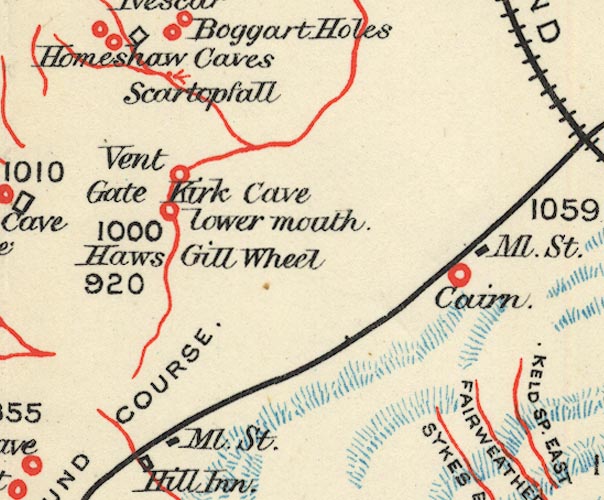 BS1SD77P.jpg "Browside Cave" item:- private collection : 27.1 Image © see bottom of page |
|
|
|
||
Lakes Guides menu.