 Old Cumbria Gazetteer
 |
 |
|
| Brayton Station, Brayton | ||
| Brayton Station | ||
| site name:- | Maryport and Carlisle Railway | |
| locality:- | Brayton | |
| civil parish:- | Aspatria (formerly Cumberland) | |
| county:- | Cumbria | |
| locality type:- | railway station | |
| coordinates:- | NY16504361 | |
| 1Km square:- | NY1643 | |
| 10Km square:- | NY14 | |
| SummaryText:- | Opened 1848; closed 1950. | |
|
|
||
| evidence:- | old map:- OS County Series (Cmd 36 2) placename:- Brayton Station item:- railway milepost |
|
| source data:- | Maps, County Series maps of Great Britain, scales 6 and 25
inches to 1 mile, published by the Ordnance Survey, Southampton,
Hampshire, from about 1863 to 1948.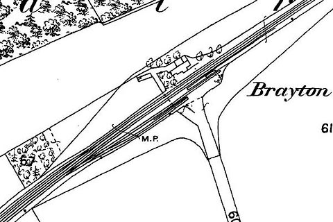 click to enlarge click to enlargeCSRY0053.jpg "Brayton Station / M.P." |
|
|
|
||
| evidence:- | probably old map:- Post Office 1850s-1900s placename:- Brayton |
|
| source data:- | Post road maps, General Post Office Circulation Map for England
and Wales, for the General Post Office, London, 1850s-1900s. click to enlarge click to enlargePOF7Cm.jpg "Brayton" map date 1909 |
|
|
|
||
| evidence:- | probably old map:- Post Office 1850s-1900s placename:- Drayton Station |
|
| source data:- | Post road maps, General Post Office Circulation Map for England
and Wales, for the General Post Office, London, 1850s-1900s. click to enlarge click to enlargePF10Cm.jpg "Drayton Sta." map date 1892 |
|
|
|
||
| evidence:- | probably old map:- Post Office 1850s-1900s placename:- Drayton Junction |
|
| source data:- | Post road maps, General Post Office Circulation Map for England
and Wales, for the General Post Office, London, 1850s-1900s. click to enlarge click to enlargePOF2Cm.jpg "Drayton Junc." map date 1890 |
|
|
|
||
| :- |
images courtesy of the British Postal Museum and Hampshire CC Museums |
|
|
|
||
 Lakes Guides menu.