 Old Cumbria Gazetteer
 |
 |
|
| Bowerbank, Barton | ||
| Bowerbank | ||
| civil parish:- | Barton (formerly Westmorland) | |
| county:- | Cumbria | |
| locality type:- | buildings | |
| coordinates:- | NY474248 | |
| 1Km square:- | NY4724 | |
| 10Km square:- | NY42 | |
|
|
||
| evidence:- | old map:- OS County Series (Wmd 7 6) placename:- Bowerbank |
|
| source data:- | Maps, County Series maps of Great Britain, scales 6 and 25
inches to 1 mile, published by the Ordnance Survey, Southampton,
Hampshire, from about 1863 to 1948. |
|
|
|
||
| evidence:- | old map:- Jefferys 1770 (Wmd) placename:- Bowers Bank |
|
| source data:- | Map, 4 sheets, The County of Westmoreland, scale 1 inch to 1
mile, surveyed 1768, and engraved and published by Thomas
Jefferys, London, 1770.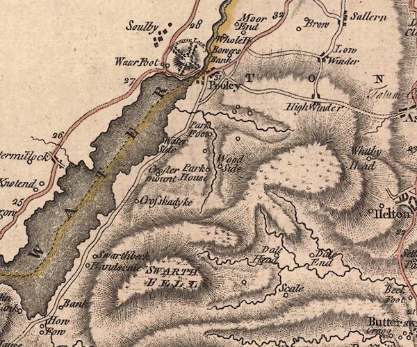 J5NY42SE.jpg "Bowers Bank" circle, labelled in italic lowercase text; settlement, farm, house, or hamlet? item:- National Library of Scotland : EME.s.47 Image © National Library of Scotland |
|
|
|
||
| evidence:- | old text:- Clarke 1787 placename:- Bower Bank placename:- Bore Bank item:- fish, Ullswater; eels; fishery |
|
| source data:- | Guide book, A Survey of the Lakes of Cumberland, Westmorland,
and Lancashire, written and published by James Clarke, Penrith,
Cumberland, and in London etc, 1787; published 1787-93. goto source goto sourcePage 39:- "... two tenements called Bower-Bank, or, (in the rental of Queen Catharine's estate,) Bore-Bank: to these belong a small fishery in Ulswater, and an eel fishery in Emont. Incredible are the numbers of eels caught here in the months of July, August, and September. During a storm of thunder, several horse loads are frequently caught in a few hours, and all the eels here are of that kind known by the name of the Silver Eel. Bower-Bank pays an annual rent of 11s. and 10d. to Kendale Castle, and has been in all probability purchased by the barons of Kendale for the sake of the fisheries." |
|
|
|
||
| evidence:- | old map:- Cary 1789 (edn 1805) placename:- Bowers Bank |
|
| source data:- | Map, uncoloured engraving, Westmoreland, scale about 2.5 miles
to 1 inch, by John Cary, London, 1789; edition 1805.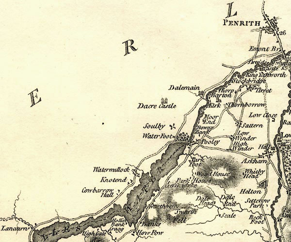 CY24NY42.jpg "Bowers Bank" block/s, labelled in italic lowercase; house, or hamlet item:- JandMN : 129 Image © see bottom of page |
|
|
|
||
| evidence:- | old print:- Farington 1789 (plate 8) |
|
| source data:- | Print, engraving, The Lower End of Ullswater, painted by Joseph Farington, engraved
by W Byrne and T Medland, published by W Byrne, 79 Titchfield Street, London, 1787.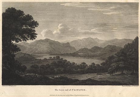 click to enlarge click to enlargeBNF10.jpg Looking south from Bowerbank, Barton. Plate 8 from Views of the Lakes, &c, in Cumberland and Westmorland, published 1789. item:- Dove Cottage : Lowther.23 Image © see bottom of page |
|
|
|
||
Lakes Guides menu.