 Old Cumbria Gazetteer
 |
 |
|
| Bowderdale, Nether Wasdale | ||
| Bowderdale | ||
| Bowderdale Farm | ||
| Bowerdale | ||
| locality:- | Wasdale | |
| civil parish:- | Nether Wasdale (formerly Cumberland) | |
| county:- | Cumbria | |
| locality type:- | buildings | |
| locality type:- | locality | |
| coordinates:- | NY16480709 | |
| 1Km square:- | NY1607 | |
| 10Km square:- | NY10 | |
|
|
||
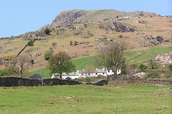 BMB59.jpg (taken 11.5.2006) |
||
|
|
||
| evidence:- | old map:- Donald 1774 (Cmd) placename:- Bouderdale |
|
| source data:- | Map, hand coloured engraving, 3x2 sheets, The County of Cumberland, scale about 1
inch to 1 mile, by Thomas Donald, engraved and published by Joseph Hodskinson, 29
Arundel Street, Strand, London, 1774.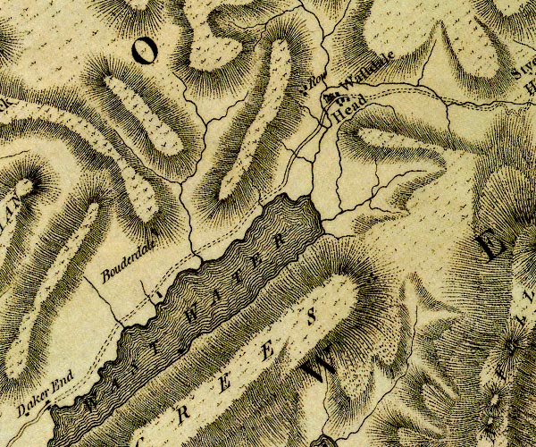 D4NY10NE.jpg "Bouderdale" block or blocks, labelled in lowercase; a hamlet or just a house item:- Carlisle Library : Map 2 Image © Carlisle Library |
|
|
|
||
| evidence:- | old print:- Green 1809 placename:- Bowderdale item:- footbridge |
|
| source data:- | Print, soft ground etching, Bridge at Bowderdale, Nether Wasdale, Cumberland, by William
Green, published by William Green, Ambleside, Westmorland, and Longman, Hurst, Rees
and Orme, Paternoster Row, London, 1809.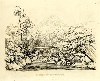 click to enlarge click to enlargeGN0346.jpg Plate 46 in Seventy Eight Studies from Nature. printed in introductory pages to set of prints:- "Number 46. Bowderdale is a solitary house, and the only one between the head and foot of Wastwater; it is about a quarter of a mile out of the road, and two thirds up the side of the lake from its foot. Wastwater is four miles in length, and more than half a mile broad; the conical mountain is Yewbarrow." printed at bottom:- "BRIDGE AT BOWDERDALE. / Published Ambleside, Augst. 1st. 1809, by W. Green." item:- Armitt Library : A6637.46 Image © see bottom of page |
|
|
|
||
| evidence:- | old text:- Green 1810 placename:- Bowderdale |
|
| source data:- | Set of prints, soft ground etchings, Sixty Studies from Nature,
by William Green, Ambleside, Westmorland, drawn 1808-10,
published 1810. goto source goto sourcepage 82:- "... a farm called Bowderdale, the only enclosed land on either side of the water, has for its boundaries on three sides, the lake, with Over Beck and Nether Beck: Bowderdale between these streams is about half a mile over. ..." |
|
|
|
||
| evidence:- | old print:- Green 1815 placename:- Bowderdale item:- clouds |
|
| source data:- | Print, coloured aquatint, Yewbarrow from Bowderdale, Nether Wasdale, Cumberland, by
William Green, Ambleside, Westmorland, 1815.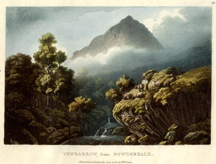 click to enlarge click to enlargeGN0555.jpg Plate 59 in Lake Scenery. printed at upper right:- "59" printed at bottom:- "YEWBARROW from BOWDERDALE. / Published at Ambleside, June 1, 1815, by Wm. Green." item:- Armitt Library : A6646.55 Image © see bottom of page |
|
|
|
||
| evidence:- | descriptive text:- Otley 1823 (5th edn 1834) |
|
| source data:- | Guide book, A Concise Description of the English Lakes, the
mountains in their vicinity, and the roads by which they may be
visited, with remarks on the mineralogy and geology of the
district, by Jonathan Otley, published by the author, Keswick,
Cumberland now Cumbria, by J Richardson, London, and by Arthur
Foster, Kirkby Lonsdale, Cumbria, 1823; published 1823-49,
latterly as the Descriptive Guide to the English Lakes. goto source Page 30:- "... Bowderdale has a single farm house, in a lateral valley opening near the middle of the lake [Wast Water]." |
|
|
|
||
| evidence:- | old map:- Ford 1839 map placename:- Bouderdale |
|
| source data:- | Map, uncoloured engraving, Map of the Lake District of
Cumberland, Westmoreland and Lancashire, scale about 3.5 miles
to 1 inch, published by Charles Thurnam, Carlisle, and by R
Groombridge, 5 Paternoster Row, London, 3rd edn 1843.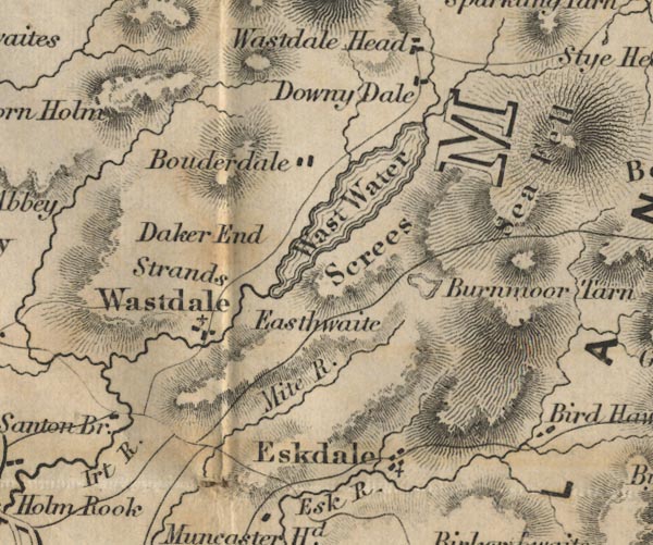 FD02NY10.jpg "Bouderdale" item:- JandMN : 100.1 Image © see bottom of page |
|
|
|
||
Lakes Guides menu.