 Old Cumbria Gazetteer
 |
 |
|
| boundary stone, Heversham/Kendal | ||
| locality:- | Barrow Green | |
| civil parish:- | Heversham (formerly Westmorland) | |
| civil parish:- | Kendal (formerly Westmorland) | |
| county:- | Cumbria | |
| locality type:- | boundary stone | |
| locality type:- | parish boundary mark | |
| coordinates:- | SD52638833 | |
| 1Km square:- | SD5288 | |
| 10Km square:- | SD58 | |
|
|
||
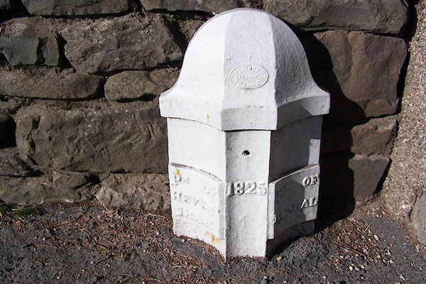 BLQ41.jpg "T. WINDER GATEBECK FOUNDRY" "PH OF HEVERSHAM / 1825 / PH OF KENDAL" (taken 1.3.2006) |
||
|
|
||
| evidence:- | database:- Listed Buildings 2010 |
|
| source data:- | courtesy of English Heritage "BOUNDARY POST APPROXIMATELY 200 YARDS NORTH OF PUNCH BOWL PUBLIC HOUSE / / A65 / STAINTON / SOUTH LAKELAND / CUMBRIA / II / 76534 / SD5262688338" "BOUNDARY POST APPROXIMATELY 200 YARDS NORTH OF PUNCH BOWL PUBLIC HOUSE / / A6 / NATLAND / SOUTH LAKELAND / CUMBRIA / II / 76449 / SD5262688337" |
|
| source data:- | courtesy of English Heritage "Boundary Post. Dated 1825. Cast Iron. Half hexagonal with fluted faces and domed top. Painted black and white. Marked: "PH OF / HEVER / SHAM" on South side and "PH OF / KENDAL" on North side. On boundary between Civil Parishes of Stainton and Natland. One of a series of similar Milestones and Boundary Posts on the old Turnpike Road." |
|
|
|
||
 Lakes Guides menu.