 Old Cumbria Gazetteer
 |
 |
|
| Bluecaster, Sedbergh | ||
| Bluecaster | ||
| civil parish:- | Sedbergh (formerly Yorkshire) | |
| county:- | Cumbria | |
| locality type:- | hill | |
| coordinates:- | SD710966 (etc) | |
| 1Km square:- | SD7196 | |
| 10Km square:- | SD79 | |
|
|
||
| evidence:- | old map:- Jefferys 1770 (Wmd) placename:- Blue Caster |
|
| source data:- | Map, 4 sheets, The County of Westmoreland, scale 1 inch to 1
mile, surveyed 1768, and engraved and published by Thomas
Jefferys, London, 1770.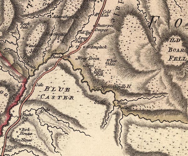 J5SD79NW.jpg "BLUE CASTER" hill hachuring; hill or mountain item:- National Library of Scotland : EME.s.47 Image © National Library of Scotland |
|
|
|
||
| evidence:- | descriptive text:- West 1778 (11th edn 1821) placename:- Blewcaster |
|
| source data:- | Guide book, A Guide to the Lakes, by Thomas West, published by
William Pennington, Kendal, Cumbria once Westmorland, and in
London, 1778 to 1821. goto source goto sourceTour to the Caves in the West Riding of Yorkshire, late 18th century Page 243:- "..." "... The Roman road is easily traced from Ribchester ... to Overborough; afterwards the Roman road goes through Casterton and Middleton, and, as some think, by Borrow-bridge and Orton, to Apulby. Others, and perhaps from better reasons, are of opinion, the road went by Sedbergh, or Sedburgh, [2] over Blewcaster, along Ravenstonedale-street, and through Kirkby-Stephen, to Brough or Burgh." "[2] Chester, or caster, is derived from the Latin word castrum, or camp. ..." |
|
|
|
||
Lakes Guides menu.