 Old Cumbria Gazetteer
 |
 |
|
| Beetham Hall, Beetham | ||
| Beetham Hall | ||
| locality:- | Beetham | |
| civil parish:- | Beetham (formerly Westmorland) | |
| county:- | Cumbria | |
| locality type:- | buildings | |
| locality type:- | castle | |
| coordinates:- | SD49977905 | |
| 1Km square:- | SD4979 | |
| 10Km square:- | SD47 | |
|
|
||
 BJS02.jpg (taken 12.8.2005) |
||
|
|
||
| evidence:- | old map:- OS County Series (Wmd 46 7) placename:- Beetham Hall |
|
| source data:- | Maps, County Series maps of Great Britain, scales 6 and 25
inches to 1 mile, published by the Ordnance Survey, Southampton,
Hampshire, from about 1863 to 1948. |
|
|
|
||
| evidence:- | possibly descriptive text:- Simpson 1746 placename:- Beltham Castle |
|
| source data:- | Atlas, three volumes of maps and descriptive text published as
'The Agreeable Historian, or the Compleat English Traveller
...', by Samuel Simpson, 1746. goto source goto sourcePage 1026:- "..." "At Beltham Castle, seven Miles from Kendale, the Earl of Derby's." |
|
|
|
||
| evidence:- | old map:- Jefferys 1770 (Wmd) placename:- Betham Hall |
|
| source data:- | Map, 4 sheets, The County of Westmoreland, scale 1 inch to 1
mile, surveyed 1768, and engraved and published by Thomas
Jefferys, London, 1770. J5SD57NW.jpg "Betham Hall" house item:- National Library of Scotland : EME.s.47 Image © National Library of Scotland |
|
|
|
||
| evidence:- | old text:- Camden 1789 (Gough Additions) placename:- Bitham Hall placename:- Bytham Hall |
|
| source data:- | Book, Britannia, or A Chorographical Description of the Flourishing Kingdoms of England,
Scotland, and Ireland, by William Camden, 1586, translated from the 1607 Latin edition
by Richard Gough, published London, 1789. goto source Page 153:- "..." "... "By Bitham is a greate park, and a goodly place in it of the earle of Darby. ..." "Bytham hall, now in ruins, is thus described by the vicar of the place 1762. "By an easy ascent from the river we come to a gateway, being the grand entrance into the castle yard. Entering there we find ourselves in a fine open area, 70 yards long, by 44 in breadth. On the right appear to have been some buildings as low as the walls of the yard to the length of 98 feet, like barracks for soldiers. On the left we have a charming view of the castle standing at the south end of the area. The walls of the yard are three feet and an half thick, with loopholes for the archers at proper distances, 12 feet high below the parapet. The loopholes are about three feet from the ground, two feet and an half in height and breadth sloping outwards to two inches and an half. The front of the house is in length 87 feet, of which the east wing is 22, and the west 26; the remaining space of 39 feet makes the hall, which is in breadth 25 feet. The windows in the hall are high up in the wall, and small in proportion to the room, with much Gothic work about them. Indeed in all the old houses in the country the windows, for the sake of defence, have been small, and strongly secured with cross bars of iron. The doors of the rooms are all little, and one above another through each story. Up one pair of stairs there hath been a chapel with a back staircase to it, whereby the tenants and neighbours might come to the chapel without disturbing the family. Southward from the castle there is a fine descent, at the foot of which is a good spring that supplies two large ponds with water. Behind the house was the park, and in one of the walks there are the remains of a lodge, and near it a spring of good water, which Camden says had a petrifying quality, but there is little or no appearance of such quality at present."" |
|
|
|
||
| evidence:- | descriptive text:- Ford 1839 (3rd edn 1843) |
|
| source data:- | Guide book, A Description of Scenery in the Lake District, by
Rev William Ford, published by Charles Thurnam, Carlisle, by W
Edwards, 12 Ave Maria Lane, Charles Tilt, Fleet Street, William
Smith, 113 Fleet Street, London, by Currie and Bowman,
Newcastle, by Bancks and Co, Manchester, by Oliver and Boyd,
Edinburgh, and by Sinclair, Dumfries, 1839. goto source Page 152:- "..." "[Beetham] ... The Hall, now a farm-house, was a large fortified mansion, standing within an area, enclosed by a wall pierced with loop-holes. ..." |
|
|
|
||
| evidence:- | old photograph:- Bell 1880s-1940s placename:- Beetham Hall |
|
| source data:- | Photograph, Beetham Hall, Windows of the Great Hall Beetham, Westmorland, by Herbert
Bell, photographer, Ambleside, Westmorland, 1894.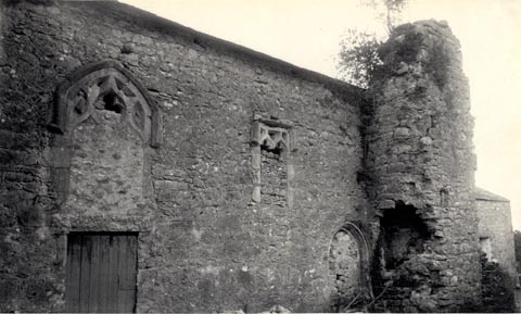 click to enlarge click to enlargeHB0110.jpg Vol.2 no.110 in an album, Examples of Early Domestic and Military Architecture in Westmorland, assembled 1910. ms at bottom:- "110. Beetham Hall. Windows of the Great Hall. Beetham. K." item:- Armitt Library : 1958.3166.3 Image © see bottom of page |
|
|
|
||
| evidence:- | old photograph:- Bell 1880s-1940s placename:- Beetham Hall |
|
| source data:- | Photograph, Beetham Hall, Defensive Wall with Breastwork, Beetham, Westmorland, by
Herbert Bell, photographer, Ambleside, Westmorland, 1894.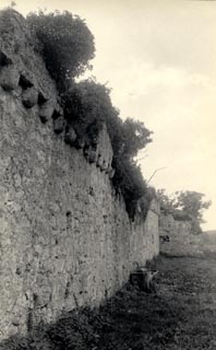 click to enlarge click to enlargeHB0111.jpg Vol.2 no.111 in an album, Examples of Early Domestic and Military Architecture in Westmorland, assembled 1910. ms at bottom:- "111. Beetham Hall, Defensive Wall with Breastwork. Beetham. K." item:- Armitt Library : 1958.3166.4 Image © see bottom of page |
|
|
|
||
| evidence:- | old photograph:- Bell 1880s-1940s placename:- Beetham Hall |
|
| source data:- | Photograph, Beetham Hall, Beetham, Westmorland, by Herbert Bell, photographer, Ambleside,
Westmorland, 1894.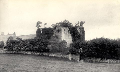 click to enlarge click to enlargeHB0109.jpg Vol.2 no.109 in an album, Examples of Early Domestic and Military Architecture in Westmorland, assembled 1910. ms at bottom:- "109. Beetham Hall. Beetham. K." item:- Armitt Library : 1958.3166.5 Image © see bottom of page |
|
|
|
||
| evidence:- | old print:- Taylor 1892 placename:- Beetham Hall |
|
| source data:- | Print, halftone photograph, Beetham Hall, Beetham, Westmorland, published for the
Cumberland and Westmorland Antiquarian and Archaeological Society, by Titus Wilson,
Kendal, Westmorland, and by Charles Thurnam and Sons, Carlisle, Cumberland, 1892.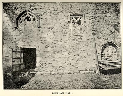 click to enlarge click to enlargeTY5042.jpg Tipped in opposite p.212 of The Old Manorial Halls of Cumberland and Westmorland, by Michael Waistell Taylor. item:- Armitt Library : A785.42 Image © see bottom of page |
|
|
|
||
| evidence:- | old print:- Curwen 1913 placename:- Beetham Hall item:- window |
|
| source data:- | Print, halftone photograph, Beetham Hall, Windows, Beetham, Westmorland, published
for the Cumberland and Westmorland Antiquarian and Archaeological Society by Titus
Wilson, Kendal, Westmorland, 1913.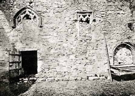 click to enlarge click to enlargeCW0149.jpg Tipped in opposite p.251 of The Castles and Fortified Towers of Cumberland, Westmorland, and Lancashire North of the Sands, by John F Curwen. printed at lower right:- "BEETHAM HALL, showing Windows to the hall." item:- Armitt Library : A782.49 Image © see bottom of page |
|
|
|
||
| evidence:- | site plan:- Historical Monuments 1936 placename:- Beetham Hall |
|
| source data:- | Site plan, uncoloured lithograph, Beetham Hall, Beetham, Westmorland, scale about
1 to 590, published by Royal Commission on Historical Monuments England, London, 1936.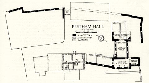 click to enlarge click to enlargeHMW030.jpg On p.41 of the Inventory of the Historical Monuments in Westmorland. printed, middle "BEETHAM HALL" RCHME no. Wmd, Beetham 2 item:- Armitt Library : A745.30 Image © see bottom of page |
|
|
|
||
| evidence:- | database:- Listed Buildings 2010 placename:- Beetham Hall |
|
| source data:- | courtesy of English Heritage "BEETHAM HALL AND ATTACHED OUTBUILDINGS / / A6 / BEETHAM / SOUTH LAKELAND / CUMBRIA / II[star] / 76555 / SD4992079055" |
|
|
|
||
| evidence:- | database:- Listed Buildings 2010 |
|
| source data:- | courtesy of English Heritage "BARN APPROXIMATELY 20 METRES NORTH EAST OF BEETHAM HALL / / A6 / BEETHAM / SOUTH LAKELAND / CUMBRIA / II / 76556 / SD4996679077" |
|
|
|
||
| evidence:- | database:- Listed Buildings 2010 |
|
| source data:- | courtesy of English Heritage "CURTAIN WALL APPROXIMATELY 30 METRES NORTH OF BEETHAM HALL / / A6 / BEETHAM / SOUTH LAKELAND / CUMBRIA / II[star] / 76557 / SD4993479114" |
|
|
|
||
| hearsay:- |
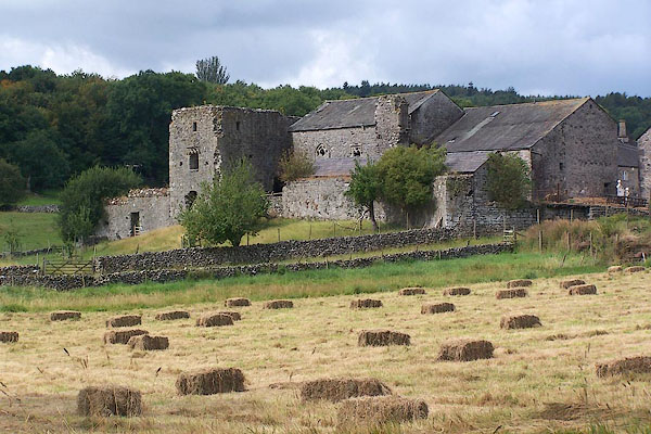
The old part is a 14th century fortified manor house of the de Beetham Family, built
1340, of which domestic rooms and a chapel still remain. There is a 17th century hall
on the site. Closed to visits. |
|
| Thomas de Beetham was granted a charter for a market and a fair, 14th century. The
market was held by the churchyard cross (which was demolished 1645). |
||
|
|
||
| notes:- |
14th century hall, tower, etc |
|
| Perriam, D R &Robinson, J: 1998: Medieval Fortified Buildings of Cumbria: CWAAS::
ISBN 1 873124 23 6; plan and illustration |
||
|
|
||
| hearsay:- |
Over a porch is:- |
|
| "T B / 1693" |
||
|
|
||
| hearsay:- |
The oldests parts are ivy covered and decaying. The porch of the part now in use has
a date stone:- |
|
| "[TMB / 1693]" |
||
| The hall once had a fortified wall, of which parts still stand 15 feet high, with
arrow slits. The hall was besieged by Fairfax in the Civil War, 1644. |
||
| Palmer, J H & McIntire, W T (ed): 1945: Historic Farmhouses in and around Westmorland:
Westmorland Gazette (Kendal, Westmorland) |
||
|
|
||
Lakes Guides menu.