 Old Cumbria Gazetteer
 |
 |
|
| beacon, Skiddaw | ||
| site name:- | Skiddaw | |
| civil parish:- | Underskiddaw (formerly Cumberland) | |
| county:- | Cumbria | |
| locality type:- | beacon (??) | |
| 1Km square:- | NY2528 (approx) | |
| 10Km square:- | NY22 | |
|
|
||
| evidence:- | descriptive text:- West 1778 (11th edn 1821) |
|
| source data:- | Guide book, A Guide to the Lakes, by Thomas West, published by
William Pennington, Kendal, Cumbria once Westmorland, and in
London, 1778 to 1821. goto source goto sourcePage 125:- "... The garrison at Keswick, would have the care of the beacon on the top of Skiddaw, the mountain being of the easiest access on that side. ..." |
|
|
|
||
| evidence:- | perhaps outline view:- Matthew 1866 placename:- Keswick Beacon |
|
| source data:- | Print, engraving, outline view, View from Watendlath Road of Derwent Water and Bassenthwaite,
Cumberland, published by J Richardson, Highgate, Kendal, Westmorland, 1866.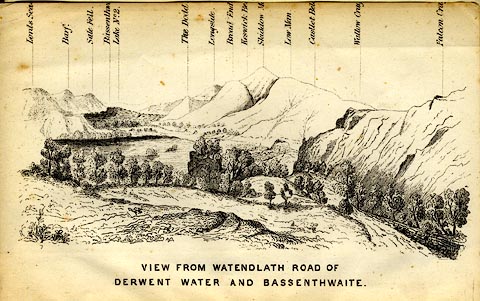 click to enlarge click to enlargeMW1E05.jpg Tipped in before p.1 of The English Lakes, Peaks and Passes, from Kendal to Keswick, by George King Matthew. printed at bottom:- "VIEW FROM WATENDLATH ROAD OF / DERWENT WATER AND BASSENTHWAITE." printed at caption to mountains:- "... Broad End / Keswick Be[ ] / Skiddow M[ ] ..." item:- Armitt Library : A1168.5 Image © see bottom of page |
|
|
|
||
| hearsay:- |
Skiddaw was one of the northern elements in a system of beacons used to warn of invaders,
and to celebrate important events. The beacons of west Cumberland were on: Black Combe,
Boothill, Moota Hill, Muncaster Fell, Skiddaw, St Bees Head, and Workington Hill.
There are said to have been two beacons on Skiddaw. (This information is not safe.) |
|
| Thomas Babington Macaulay in The Armada:- |
||
| "Til Skiddaw saw the fire that burned on Gaunt's embattled pile And the red glare on Skiddaw roused the burghers of Carlisle" |
||
| which is slightly wishful thinking, they call it poetic licence, as Skiddaw could
hardly have seen a beacon at Lancaster, and Carlisle would have difficulty with Skiddaw. |
||
|
|
||
Lakes Guides menu.