 Old Cumbria Gazetteer
 |
 |
|
| Bardsea Hall, Bardsea | ||
| gone | ||
| Bardsea Hall | ||
| locality:- | Bardsea | |
| civil parish:- | Urswick (formerly Lancashire) | |
| county:- | Cumbria | |
| locality type:- | buildings | |
| coordinates:- | SD30077480 (?) | |
| 1Km square:- | SD3074 | |
| 10Km square:- | SD37 | |
|
|
||
| evidence:- | old map:- OS County Series (Lan 16 12) placename:- Bardsea Hall |
|
| source data:- | Maps, County Series maps of Great Britain, scales 6 and 25
inches to 1 mile, published by the Ordnance Survey, Southampton,
Hampshire, from about 1863 to 1948. |
|
|
|
||
| evidence:- | old map:- West 1784 map placename:- Bardsea Hall |
|
| source data:- | Map, hand coloured engraving, A Map of the Lakes in Cumberland,
Westmorland and Lancashire, scale about 3.5 miles to 1 inch,
engraved by Paas, 53 Holborn, London, about 1784.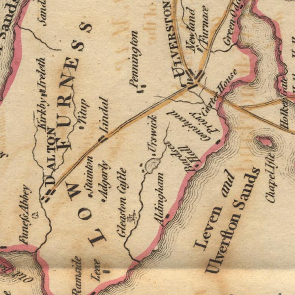 Ws02SD27.jpg item:- Armitt Library : A1221.1 Image © see bottom of page |
|
|
|
||
| evidence:- | old text:- Camden 1789 (Gough Additions) placename:- Bardsay Hall |
|
| source data:- | Book, Britannia, or A Chorographical Description of the Flourishing Kingdoms of England,
Scotland, and Ireland, by William Camden, 1586, translated from the 1607 Latin edition
by Richard Gough, published London, 1789. goto source goto sourcePage 143:- "Bardsay hall, the seat of a family of its name now extinct, and afterwards of lord Molyneux, is an antient building on rock with costly gardens, now belonging to Wilson Braddyll, esq." |
|
|
|
||
| evidence:- | old print:- Jopling 1843 |
|
| source data:- | Print, Bardsea Hall, Bardsea, Urswick, Lancashire, by Charles M Jopling, published
by Whittaker and Co, Ave Maria Lane, London and by Stephen Soulby, Ulverston, Cumberland,
1843.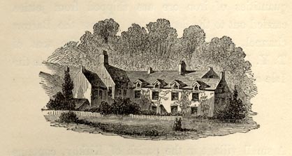 click to enlarge click to enlargeJP1E04.jpg On p.23 of a Sketch of Furness and Cartmel, by Charles M Jopling. item:- Armitt Library : A1636.5 Image © see bottom of page |
|
|
|
||
| notes:- |
site of a medieval hall |
|
| Perriam, D R &Robinson, J: 1998: Medieval Fortified Buildings of Cumbria: CWAAS::
ISBN 1 873124 23 6; illustration |
||
|
|
||
| notes:- |
Demolished 1930s |
|
|
|
||
Lakes Guides menu.