 Old Cumbria Gazetteer
 |
 |
|
| Armboth, St John's Castlerigg etc | ||
| Armboth | ||
| civil parish:- | St John's Castlerigg and Wythburn (formerly Cumberland) | |
| county:- | Cumbria | |
| locality type:- | locality | |
| coordinates:- | NY305171 | |
| 1Km square:- | NY3017 | |
| 10Km square:- | NY31 | |
| SummaryText:- | Whatever was the hamlet of Armboth was flooded when the lakes became a reservoir. | |
|
|
||
| evidence:- | old map:- OS County Series (Cmd 70 8) placename:- Armboth |
|
| source data:- | Maps, County Series maps of Great Britain, scales 6 and 25
inches to 1 mile, published by the Ordnance Survey, Southampton,
Hampshire, from about 1863 to 1948. |
|
|
|
||
| evidence:- | old map:- Mercator 1595 (edn?) placename:- Armebath |
|
| source data:- | Map, hand coloured engraving, Northumbria, Cumberlandia, et
Dunelmensis Episcopatus, ie Northumberland, Cumberland and
Durham etc, scale about 6.5 miles to 1 inch, by Gerard Mercator,
Duisberg, Germany, about 1595.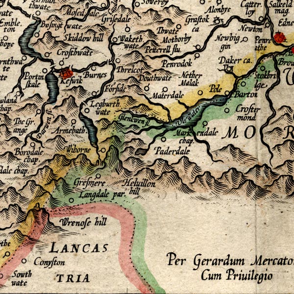 MER8CumF.jpg "Armebath" circle item:- JandMN : 169 Image © see bottom of page |
|
|
|
||
| evidence:- | old map:- Speed 1611 (Cmd) placename:- Armebath |
|
| source data:- | Map, hand coloured engraving, Cumberland and the Ancient Citie
Carlile Described, scale about 4 miles to 1 inch, by John Speed,
1610, published by J Sudbury and George Humble, Popes Head
Alley, London, 1611-12.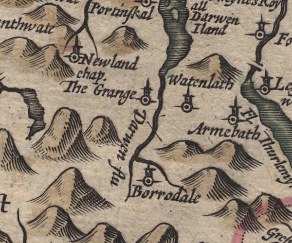 SP11NY21.jpg "Armebath" circle, tower item:- private collection : 16 Image © see bottom of page |
|
|
|
||
| evidence:- | old map:- Jansson 1646 placename:- Armebath |
|
| source data:- | Map, hand coloured engraving, Cumbria and Westmoria, ie
Cumberland and Westmorland, scale about 3.5 miles to 1 inch, by
John Jansson, Amsterdam, Netherlands, 1646.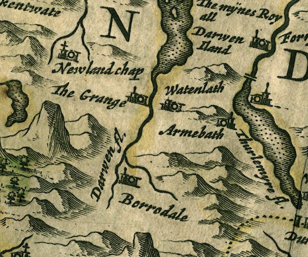 JAN3NY21.jpg "Armebath" Buildings and tower. item:- JandMN : 88 Image © see bottom of page |
|
|
|
||
| evidence:- | old map:- Morden 1695 (Cmd) placename:- Armeboth |
|
| source data:- | Map, uncoloured engraving, Cumberland, scale about 4 miles to 1
inch, by Robert Morden, 1695, published by Abel Swale, the
Unicorn, St Paul's Churchyard, Awnsham, and John Churchill, the
Black Swan, Paternoster Row, London, 1695-1715.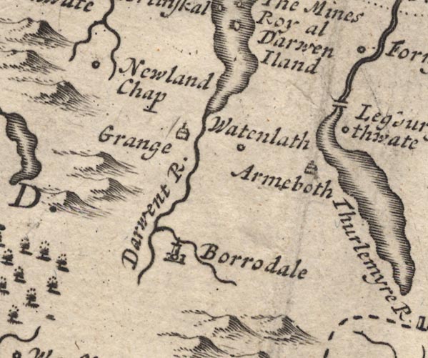 MD12NY21.jpg "Armeboth" Drawing of a house. item:- JandMN : 90 Image © see bottom of page |
|
|
|
||
| evidence:- | old map:- Bowen and Kitchin 1760 placename:- Armeboth |
|
| source data:- | Map, hand coloured engraving, A New Map of the Counties of
Cumberland and Westmoreland Divided into their Respective Wards,
scale about 4 miles to 1 inch, by Emanuel Bowen and Thomas
Kitchin et al, published by T Bowles, Robert Sayer, and John
Bowles, London, 1760.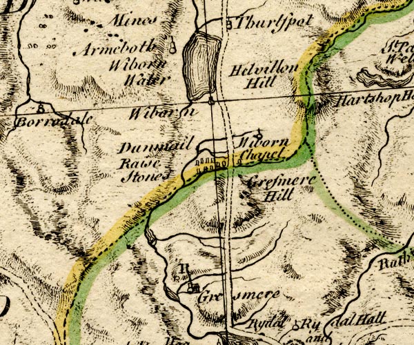 BO18NY20.jpg "Armeboth" circle, tower item:- Armitt Library : 2008.14.10 Image © see bottom of page |
|
|
|
||
| evidence:- | old map:- Donald 1774 (Cmd) placename:- Armbath |
|
| source data:- | Map, hand coloured engraving, 3x2 sheets, The County of Cumberland, scale about 1
inch to 1 mile, by Thomas Donald, engraved and published by Joseph Hodskinson, 29
Arundel Street, Strand, London, 1774. D4NY31NW.jpg "Armbath" block or blocks, labelled in lowercase; a hamlet or just a house item:- Carlisle Library : Map 2 Image © Carlisle Library |
|
|
|
||
| evidence:- | old text:- Clarke 1787 placename:- Armboth |
|
| source data:- | Guide book, A Survey of the Lakes of Cumberland, Westmorland,
and Lancashire, written and published by James Clarke, Penrith,
Cumberland, and in London etc, 1787; published 1787-93. goto source goto sourcePage 117:- "..." "From the top of the hill in Leathes Park is a view of Armboth, which is situated on the other side of the lake; the sight is very unexpected, and exhibits a few cottages sheltered from the north, surrounded by fine rich cultivated plains, with the lake in front: at this sweet retirement lives Mr Jackson, who possesses the manor, which is small, but abounds in game; he likewise claims a right of navigation upon the lake." |
|
|
|
||
| evidence:- | old map:- Clarke 1787 map (Ambleside to Keswick) placename:- Armboth |
|
| source data:- | Map, A Map of the Roads Lakes etc between Keswick and Ambleside,
scale about 2.5 ins to 1 mile, by James Clarke, engraved by S J
Neele, 352 Strand, published by James Clarke, Penrith,
Cumberland and in London etc, 1787.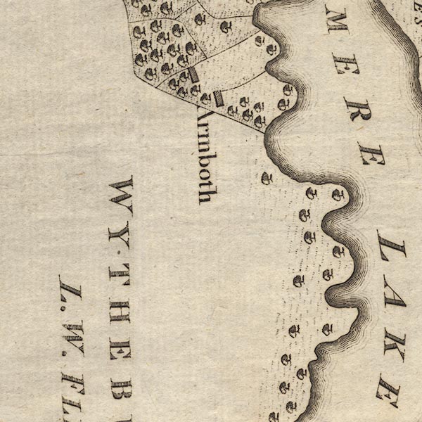 CL9NY31C.jpg "Armboth" item:- private collection : 10.9 Image © see bottom of page |
|
|
|
||
| evidence:- | old text:- Green 1810 placename:- Armbath |
|
| source data:- | Set of prints, soft ground etchings, Sixty Studies from Nature,
by William Green, Ambleside, Westmorland, drawn 1808-10,
published 1810. goto source page 56:- "..." "Between the head of the lake and Armbath, the property and residence of Mr. Jackson, is a fine view of the upper and lower waters, elegantly adorned on their margins with woods, and screened on the sides by the How and Raven Crag; ..." |
|
|
|
||
| evidence:- | old print:- Green 1814 (plate 25) placename:- Armbath item:- cattle |
|
| source data:- | Print, uncoloured soft ground etching, Leaths Water from Armbath, ie Thirlmere, St
John's Castlerigg and Wythburn, Cumberland, by William Green, Ambleside, Westmorland,
1814.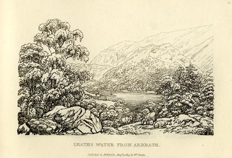 click to enlarge click to enlargeGN0925.jpg Plate 25 in Sixty Small Prints. printed at top right:- "25" printed at bottom:- "LEATHS WATER FROM ARMBATH. / Published at Ambleside Augst. 1, 1814, by Wm. Green." item:- Armitt Library : A6656.25 Image © see bottom of page |
|
|
|
||
| evidence:- | old print:- Green 1814 (plate 25) placename:- Armbath item:- cattle |
|
| source data:- | Print, tinted soft ground etching, Leaths Water from Armbath, ie Thirlmere, St John's
Castlerigg and Wythburn, Cumberland, by William Green, Ambleside, Westmorland, 1814.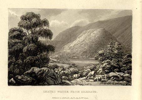 click to enlarge click to enlargeGN1025.jpg Plate 25 in Sixty Small Prints. printed at top right:- "25" printed at bottom:- "LEATHS WATER FROM ARMBATH. / Published at Ambleside Augst. 1, 1814, by Wm. Green." item:- Armitt Library : A6653.25 Image © see bottom of page |
|
|
|
||
| evidence:- | old map:- Otley 1818 placename:- Armboth |
|
| source data:- | Map, uncoloured engraving, The District of the Lakes,
Cumberland, Westmorland, and Lancashire, scale about 4 miles to
1 inch, by Jonathan Otley, 1818, engraved by J and G Menzies,
Edinburgh, Scotland, published by Jonathan Otley, Keswick,
Cumberland, et al, 1833.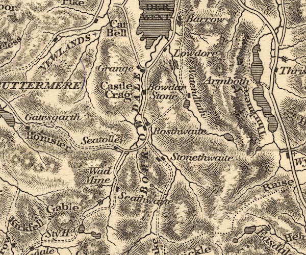 OT02NY21.jpg item:- JandMN : 48.1 Image © see bottom of page |
|
|
|
||
| evidence:- | old photograph:- Bell 1880s-1940s |
|
| source data:- | Photograph, sepia, farm buildings at Armboth, St John's Castlerigg and Wythburn, Cumberland,
by Herbert Bell, photographer, Ambleside, Westmorland, 1890s.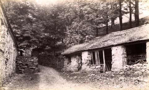 click to enlarge click to enlargeHB0731.jpg item:- Armitt Library : ALPS395 Image © see bottom of page |
|
|
|
||
| evidence:- | old photograph:- Bell 1880s-1940s item:- footbridge |
|
| source data:- | Photograph, sepia, footbridge, Armboth, St John's Castlerigg and Wythburn, Cumberland,
by Herbert Bell, photographer, Ambleside, Westmorland, 1890s.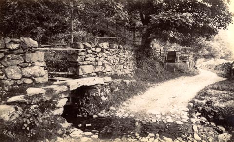 click to enlarge click to enlargeHB0733.jpg internegative at lower left:- "H. Bell" item:- Armitt Library : ALPS397 Image © see bottom of page |
|
|
|
||
Lakes Guides menu.