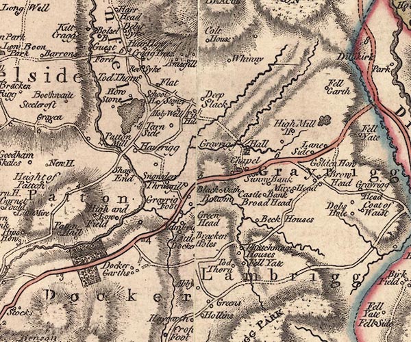
 Jefferys 1770 SD59NE

|

|
|
|
gazetteer links places may or may not be labelled on the map |
||

|
-- Abbey -- "Abby" |
|
|
|
-- Agnes Gill -- "Anisgill" |
|
|
|
-- Beck Houses -- "Beck Houses" |
|
|
|
-- Blackett Bottom -- "Black Oath Bottom" |
|
|
|
-- Bracken Hall Cottage -- "Bracken Holes" |
|
|
|
-- Bracken Hall -- "Bracken Holes" |
|
|
|
-- bridge, Beck Houses |
|
|
|
-- Broad Head -- "Broad Head" |
|
|
|
-- Brow Head -- "Brow Head" |
|
|
|
-- Castley Bank -- "Castle Bank" |
|
|
|
-- Cote House -- "Colt House" |
|
|
|
-- Craketrees -- "Cragg Trees" |
|
|
|
-- Docker Bridge |
|
|
|
-- Docker Garth -- "Docker Garths" |
|
|
|
-- Docker -- "Docker" |
|
|
|
-- Fell Gate -- "Fell Yate" |
|
|
|
-- Fellgarth -- "Fell Garth" |
|
|
|
-- Field End -- "High Low and Low Field" |
|
|
|
-- Flat -- "Flat" |
|
|
|
-- Flodder Beck |
|
|
|
-- Guest Ford (?) |
|
|
|
-- Golden Howe -- "Golden How" |
|
|
|
-- Grayrigg Foot -- "Grayrig Foot" |
|
|
|
-- Grayrigg Hall Beck |
|
|
|
-- Grayrigg Hall -- "Grayrigg Hall" |
|
|
|
-- Grayrigg Tarn |
|
|
|
-- Grayrigg -- "Grayrigg" |
|
|
|
-- Green Head -- "Green Head" |
|
|
|
-- Green, The -- "Greens" |
|
|
|
-- Guestford -- "Guest Ford" |
|
|
|
-- Harehowe -- "Hair How" |
|
|
|
-- Haveriggs -- "Haverigg" |
|
|
|
-- High Deepslack -- "Deep Slack" |
|
|
|
-- High Fellgarth -- "Fell Garth" |
|
|
|
-- High Mill -- "High Mill H." |
|
|
|
-- Holy Well -- "Holy Well" |
|
|
|
-- Howestone -- "How Stone" |
|
|
|
-- Lambrigg Beck |
|
|
|
-- Lambrigg Foot -- "Lambri[g ]" |
|
|
|
-- Lambrigg -- "Lambrigg" |
|
|
|
-- Laneside -- "Lane Side" |
|
|
|
-- Little Docker -- "Little Docker" |
|
|
|
-- Low Deepslack -- "Deep Slack" |
|
|
|
-- Low Fellgarth -- "Fell Garth" |
|
|
|
-- milestone, Docker -- "4" |
|
|
|
-- Mires Head -- "Mire Head" |
|
|
|
-- Old Field End -- "High Low and Low Field" |
|
|
|
-- Oldfield -- "High Low and Low Field" |
|
|
|
-- Patton Bridge |
|
|
|
-- Patton Mill -- "Patton Mill" |
|
|
|
-- Patton -- "Patton" |
|
|
|
-- Redsikes -- "Red Syke" |
|
|
|
-- Kendal to Tebay |
|
|
|
-- Mealbank Road (etc) |
|
|
|
-- School House -- "School H." |
|
|
|
-- Shaw End -- "Shaw End" |
|
|
|
-- Snowdon -- "Snowden" |
|
|
|
-- St John's Church -- "Chapel" |
|
|
|
-- Stone Hall -- "Stoney" |
|
|
|
-- Sunny Bank -- "Sunny Bank" |
|
|
|
-- Tarnside House -- "Tarn Side" |
|
|
|
-- Tarnside -- "Pit[ ] Hil[l]" |
|
|
|
-- Thatchmoor Head -- "Thatchman Houses" |
|
|
|
-- Thursgill -- "Thrusgill" |
|
|
|
-- Tod Thorn -- "Tod Thorn" |
|
|
|
-- Topthorn -- "Tod Thorn" |
|
|
|
-- Whinfell Tarn |
|
|
|
-- Whinfell -- "Whinfell" |
|
|
|
-- Whinhowe Gill |
|
|
|
-- Whinhowe -- "Whinny" |
|
|
civil parishes The area roughly includes parts of parishes:- Whitwell and Selside Whinfell Grayrigg Docker Lambrigg |
||
|
|
||
|
|
Lakes Guides menu. | |