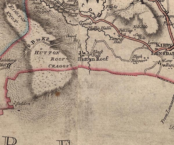
 Jefferys 1770 SD57NE

|

|
|
|
gazetteer links places may or may not be labelled on the map |
||

|
-- Black Bull -- "Black Bull" |
|
|
|
-- bridge, Hutton Roof |
|
|
|
-- Catholes -- "Cats Hole" |
|
|
|
-- Fell Side -- "Fell Side" |
|
|
|
-- High Biggins -- "High Biggin" |
|
|
|
-- Hollin Hall -- "Hollin Hall" |
|
|
|
-- Hutton Roof Crags -- "HUTTON ROOF CRAGGS" |
|
|
|
-- Hutton Roof -- "Hutton Roof" |
|
|
|
-- Little Spittal -- "Spittle" |
|
|
|
-- Kendal to Kirkby Lonsdale-- Kendal to Kirkby Lonsdale |
|
|
|
-- Hutton Roof road -- "F. B. to K. 6.[1]" |
|
|
|
-- Sealford Beck |
|
|
|
-- Spital Farm -- "Spittle" |
|
|
|
-- Spittal Bridge |
|
|
|
-- St John's Church -- "Chapel" |
|
|
|
-- Tearnside Cottage -- "Fell Yate" |
|
|
|
-- Tearnside Hall -- "Tarnside Hall" |
|
|
civil parishes The area roughly includes parts of parishes:- Hutton Roof Burton-in-Kendal Kirkby Lonsdale |
||
|
counties The area includes parts of counties:- Lancashire |
||
|
|
||
|
|
Lakes Guides menu. | |