 Jefferys 1770 SD48NW

|

|
|
|
gazetteer links places may or may not be labelled on the map |
||

|
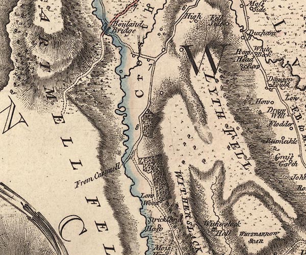
-- Arndale Beck |
|
|
|
-- Bowland Bridge -- "Bouland Bridge" |
|
|
|
-- Bowland Bridge -- "Bouland Bridge" |
|
|
|
-- Cartmel Fell -- "CARTMELL FELLS" |
|
|
|
-- Durham Bridge Farm -- "Durham B." |
|
|
|
-- Durham Bridge -- "Durham B." |
|
|
|
-- High Low Wood -- "Low Wood" |
|
|
|
-- Little Strickland Hill -- "Strickland Haw" |
|
|
|
-- Lobby Bridge |
|
|
|
-- Low Wood -- "Low Wood" |
|
|
|
-- Lyth Fell -- "LYTH FELL" |
|
|
|
-- Middle Low Wood -- "Low Wood" |
|
|
|
-- Kendal to Newby Bridge |
|
|
|
-- Witherslack road -- "From Cartmell" -- "From
Cartmell" |
|
|
|
-- Row Head -- "Row Head" |
|
|
|
-- Row -- "Row" |
|
|
|
-- Strickland Hill -- "Strickland Haw" |
|
|
|
-- Whitbarrow Scar -- "WITHERSLACK SCAR / WHITBARROW
SCAR" |
|
|
|
-- Witherslack Hall |
|
|
civil parishes The area roughly includes parts of parishes:- Staveley-in-Cartmel Cartmel Fell Upper Allithwaite Witherslack Crosthwaite and Lyth |
||
|
|
||
|
|
Lakes Guides menu. | |