 Jefferys 1770 NY62SW

|

|
|
|
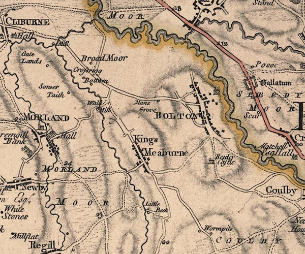
gazetteer links places may or may not be labelled on the map |
||

|
-- All Saints Church |
|
|
|
-- Bewley Castle -- "Bewley Castle" |
|
|
|
-- Birdby Farm -- "Broad Moor" |
|
|
|
-- Bolton -- "BOLTON" |
|
|
|
-- Cliburn Mill -- "Mill" |
|
|
|
-- Crossrigg Farm -- "Bottom" |
|
|
|
-- Crossrigg Hall -- "Crossrigg" |
|
|
|
-- Eden, River -- "Eden River" -- "Eden
River" -- "Eden R." |
|
|
|
-- King's Meaburn -- "Kings Meaburne" |
|
|
|
-- Kirkby Thore Bridge |
|
|
|
-- Little Beck -- "Little Beck" |
|
|
|
-- Lyvennet, River |
|
|
|
-- Mansgrove -- "Mans Grove" |
|
|
|
-- milestone, Crackenthorpe -- "12" |
|
|
|
-- Morland Hall -- "Hall" |
|
|
|
-- Morland Moor -- "MORLAND MOOR" |
|
|
|
-- Appleby to Penrith |
|
|
|
-- Crosby Ravensworth road |
|
|
|
-- Morland and Cliburn road |
|
|
|
-- Trout Beck |
|
|
|
-- Walk Mill -- "Wall Mill" |
|
|
|
-- Winter House -- "Sower Taith" |
|
|
civil parishes The area roughly includes parts of parishes:- Morland Bolton Temple Sowerby Crackenthorpe Long Marton Kirkby Thore King's Meaburn |
||
|
|
||
|
|
Lakes Guides menu. | |