 Jefferys 1770 NY50SW

|

|
|
|
gazetteer links places may or may not be labelled on the map |
||

|
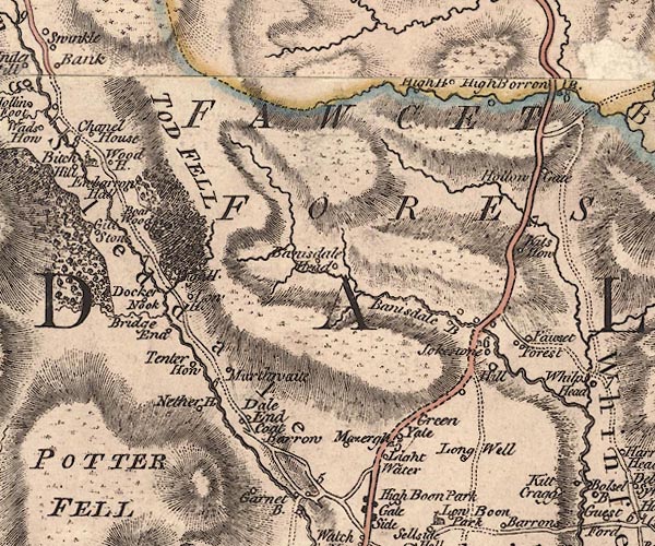
-- Bannisdale Beck -- "Banisdale B" |
|
|
|
-- Bannisdale Head -- "Banisdale Head" |
|
|
|
-- Bannisdale High Bridge |
|
|
|
-- Bowers Wood |
|
|
|
-- Bridge End -- "Bridge End" |
|
|
|
-- bridge, Fawcett Forest |
|
|
|
-- Capplebarrow House -- "Wood H." |
|
|
|
-- Dale End -- "Dale End" |
|
|
|
-- Docker Nook -- "Docker Nook" |
|
|
|
-- Dockernook Gill |
|
|
|
-- Fawcett Forest -- "FAWCET FOREST" -- "Fawset
Forest" |
|
|
|
-- High House -- "High H." |
|
|
|
-- High House -- "High H." |
|
|
|
-- Hill -- "Hill" |
|
|
|
-- Hollowgate -- "Hollow Gate" |
|
|
|
-- Katebarrow -- "Coat Barrow" |
|
|
|
-- Kidshowe -- "Kits How" |
|
|
|
-- Light Water -- "Light Water" |
|
|
|
-- Longsleddale -- "Long Sleddale" |
|
|
|
-- Longwell -- "Long Well" |
|
|
|
-- Low House -- "Low H." |
|
|
|
-- Low Jock Scar -- "Jokestone" |
|
|
|
-- milestone, Fawcett Forest -- "7" |
|
|
|
-- milestone, Fawcett Forest -- "8" |
|
|
|
-- milestone, Selside -- "5" |
|
|
|
-- milestone, Selside -- "6" |
|
|
|
-- Mosergh Farm -- "Mazergh" |
|
|
|
-- Murthwaite -- "Murthwaite" |
|
|
|
-- Nether House Farm -- "Nether H." |
|
|
|
-- North Gateside -- "Green Yate" |
|
|
|
-- Garnett Bridge to Sadgill |
|
|
|
-- Kendal to Shap |
|
|
|
-- Tenter Howe -- "Tenter How" |
|
|
|
-- Todd Fell -- "TOD FELL" |
|
|
|
-- Ubarrow Hall -- "Ewbarrow Hall" |
|
|
|
-- Whiteside |
|
|
|
-- Winnows, The |
|
|
civil parishes The area roughly includes parts of parishes:- Longsleddale Fawcett Forest Strickland Roger Whitwell and Selside Shap Rural |
||
|
|
||
|
|
Lakes Guides menu. | |