 Jansson 1646
 |
 |
|
|
Places Identified
Map, hand coloured engraving, Cumbria and Westmoria, ie Cumberland and Westmorland, scale about 3.5 miles to 1 inch, by John Jansson, Amsterdam, Netherlands, 1646. NB: each image includes an overlap, places in the overlap are not listed. The images are roughly equivalent to ngr 10Km squares and are listed from top left to bottom right. | ||
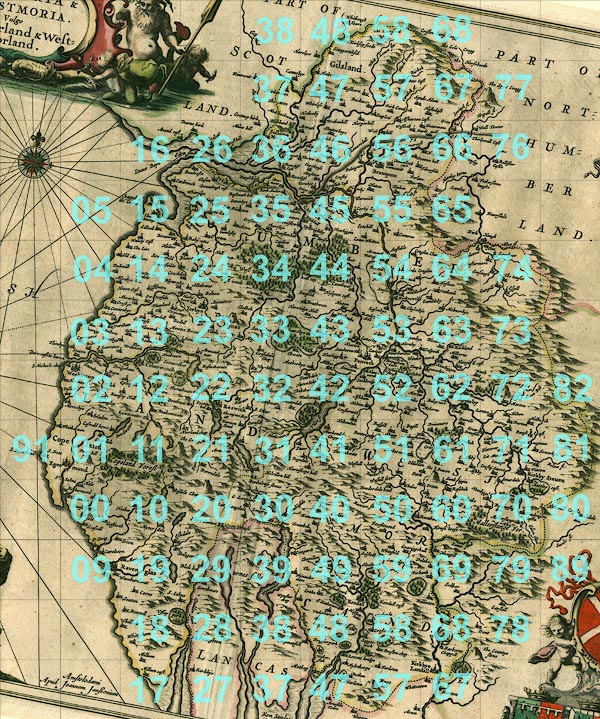 ScJAN3Sq.jpg
 | ||
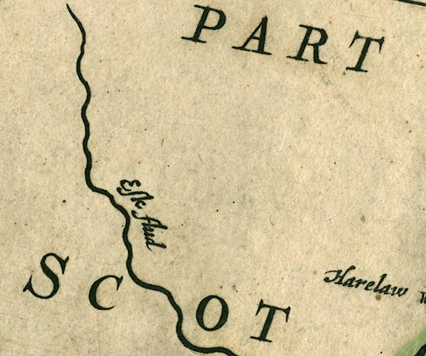 JAN3NY38.jpg
 |
Esk, River -- river -- boundary -- county boundary etc --
NY3666 (etc)
-- 'Esk flud' -- Double line with stream lines, tapering to
single wiggly line.
| |
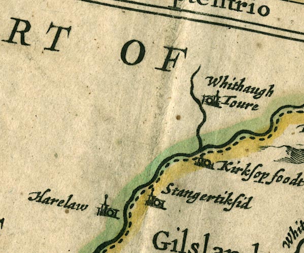 JAN3NY48.jpg
 |
Harelaw -- building/s -- NY4378
-- 'Harelaw' -- Buildings and tower.
Kershope Burn -- river -- boundary -- NY5184 (etc etc) -- Single wiggly line; country boundary. Kershopefoot -- building/s -- NY475829 (?) ? -- 'Kirksop foodt' -- Buildings and tower. Liddel Water -- river -- boundary -- national boundary -- county boundary -- NY4377 (etc) -- Double wiggly line, tapering to single; country boundary. Stonegarthside Hall -- building/s -- NY480819 ? -- 'Stangertiksid' -- Buildings and tower. Whithaugh Tower -- tower -- NY4988 -- 'Whithaugh Toure' -- Buildings and tower. | |
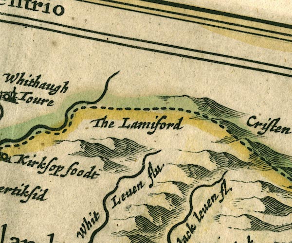 JAN3NY58.jpg
 |
Black Lyne -- river -- NY5075
-- 'Whit Leven flu.' -- Single wiggly line; White and Black
Lyne are the wrong way round, as on Saxton 1576.
Kershope Burn -- river -- boundary -- NY5184 (etc etc) -- Single wiggly line; country boundary. Lamiford -- NY58 -- 'The Lamiford' -- Hillock on county boundary. | |
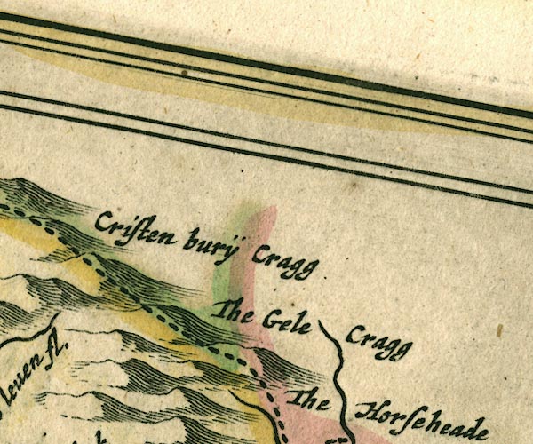 JAN3NY68.jpg
 |
Christianbury Crag -- hill -- NY577822
-- 'Cristen burÿ Cragg' -- Hillock, on county
boundary.
Gill Pike -- hill -- NY614838 ? -- 'The gele cragg' -- Hillock on county boundary. | |
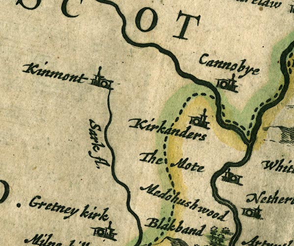 JAN3NY37.jpg
 |
Canonbie -- building/s -- NY392764
-- 'Cannobye' -- Buildings and tower.
Esk, River -- river -- boundary -- county boundary etc -- NY3666 (etc) -- 'Esk flud' -- Double line with stream lines, tapering to single wiggly line. Kinmont (?) -- building/s -- house -- NY37 -- 'Kinmont' -- Buildings and tower. probably Kirkandrews -- locality -- NY3569 (etc) -- 'Kirkanders' -- Buildings and tower. Moat -- building/s -- NY411739 ? -- 'The Mote' -- Buildings and tower. Sark, River -- river -- boundary -- national boundary -- county boundary -- NY3372 (etc) -- 'Sark fl.' -- Single wiggly line; country boundary for a short stretch. | |
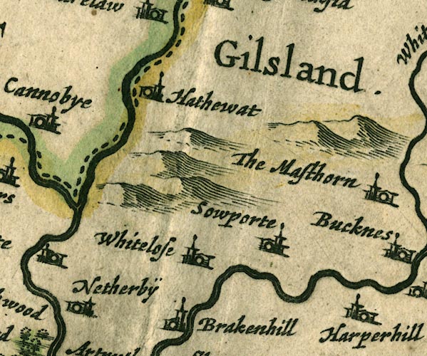 JAN3NY47.jpg
 |
Gilsland (?) -- locality -- NY47 (etc)
-- 'Gilsland.' -- Labelling an area, no symbol.
Haithwaite -- building/s -- NY443773 ? -- 'Hathewat' -- Buildings and tower. Kershope Burn -- river -- boundary -- NY5184 (etc etc) -- Single wiggly line; country boundary. Liddel Water -- river -- boundary -- national boundary -- county boundary -- NY4377 (etc) -- Double wiggly line, tapering to single; country boundary. Netherby -- building/s -- NY398715 -- 'Netherbÿ' -- Buildings and tower. Solport -- locality -- NY4773 (?etc) -- 'Sowporte' -- Buildings and tower. Whiteclose -- building/s -- NY467709 -- 'Whitelose' -- Buildings and tower. | |
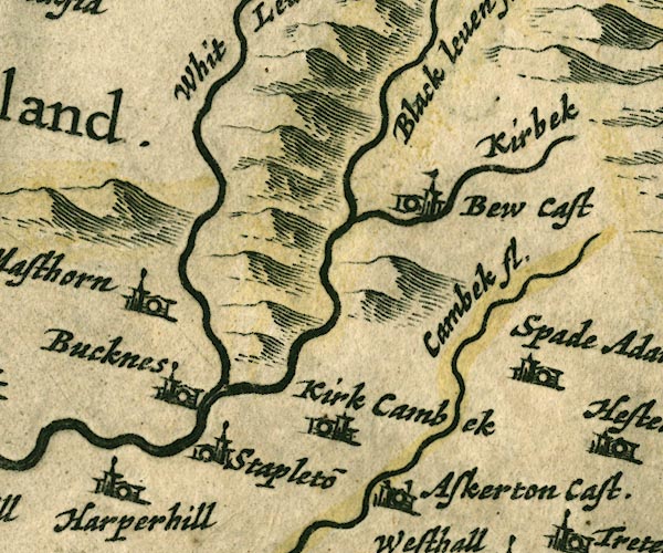 JAN3NY57.jpg
 |
Askerton Castle -- castle -- NY5569 ?
-- 'Askerton Cast.' -- Buildings and tower with flag.
Bew Castle -- castle -- NY56567468 -- 'Bew Cast' -- Buildings and tower with flag. Cam Beck -- river -- NY5469 (etc) -- 'Cambek fl.' -- Single wiggly line. Harperhill -- building/s -- NY501716 -- 'Harperhill' -- Buildings and tower. High Mossthorn -- building/s -- NY514734 ? ? -- 'The Masthorn' -- Buildings and tower. probably Kirk Beck -- river -- NY5774 (etc) -- 'Kirbek' -- Single wiggly line. Kirkcambeck -- building/s -- NY534689 -- 'Kirk Cambek' -- Buildings and tower. Low Luckens -- building/s -- NY493726 -- 'Bucknes' -- Buildings and tower. Spadeadam -- building/s -- NY585706 -- 'Spade Adam' -- Buildings and tower. Stapleton -- building/s -- NY505712 -- 'Stapleto~' -- Buildings and tower. White Lyne -- river -- NY4973 (etc) -- 'Black leven fl.' -- Single wiggly line; White and Black Lyne are the wrong way round, as on Saxton 1576. | |
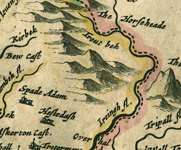 JAN3NY67.jpg
 |
Gair Burn -- river -- boundary -- NY6278 (etc) ?
-- 'Trout bek' -- Single wiggly line; county boundary.
probably
Highstead Ash -- building/s -- NY599692 -- 'Hestedash' -- Buildings and tower. Horse Head -- hill -- NY617810 (?) -- 'The Horse head' -- Hillock on county boundary. Irthing, River -- river -- boundary -- county boundary -- NY4758 (etc etc) -- 'Ireingh fl.' -- Double wiggly line, tapering to single. | |
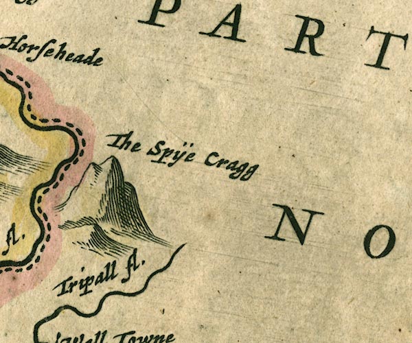 JAN3NY77.jpg
 |
Spy Rigg -- hill -- NY688758
-- 'The Spÿe Cragg' -- large lumpy hillock near the
county boundary
Tipalt Burn -- river -- NY6963 -- 'Tripall fl.' -- Single wiggly line. | |
 JAN3NY16.jpg
 |
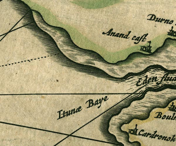
Annan Castle -- castle -- NY1966 (?)
-- 'Anand cast' -- Buildings and tower with flag.
Solway Firth -- estuary -- river estuary -- sea area -- NY16 (etc) ? -- 'Eden flude' -- 'Itunae Baye' | |
 JAN3NY26.jpg
 |
Bowness-on-Solway -- building/s -- NY224628
-- 'Boulnesse' -- Buildings and tower.
Dornock -- building/s -- NY231660 -- 'Durno kirk' -- Buildings and tower. Eden, River -- river etc -- NY3658 (etc) -- 'Eden flude' -- 'Eden flu.' -- 'Eden flud' -- Double line with stream lines, tapering to single line; county boundary for a short stretch. Glasson -- building/s -- NY2560 -- 'Glason' -- Buildings and tower. Hadrian's Wall -- roman wall -- roman site -- NY6166 (etc) -- 'THE PICTS WAL.' -- 'THE PICTS WAL.' -- Drawn as a squarely built wall; from Bowness on Solway, through Carlisle, then north and east into Northumberland. Solway Firth -- estuary -- river estuary -- sea area -- NY16 (etc) ? -- 'Eden flude' -- 'Itunae Baye' Torduff -- locality -- NY264639 -- 'Tordoff' -- Buildings and tower. Westhills -- building/s -- NY272654 -- 'Westhill' -- Buildings and tower. | |
 JAN3NY36.jpg
 |
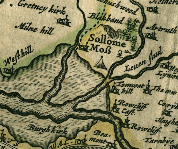
Battle of Solway Moss -- battle site -- NY3469
-- 'Sollome Moss' -- Tent symbol.
Blackbank -- building/s -- NY3467 -- 'Blakband' -- No symbol. Eden, River -- river etc -- NY3658 (etc) -- 'Eden flude' -- 'Eden flu.' -- 'Eden flud' -- Double line with stream lines, tapering to single line; county boundary for a short stretch. Esk, River -- river -- boundary -- county boundary etc -- NY3666 (etc) -- 'Esk flud' -- Double line with stream lines, tapering to single wiggly line. Gretna -- building/s -- NY317670 -- 'Gretney kirk' -- Buildings and tower. Lyne, River -- river etc -- NY3765 (etc) -- 'Leven flud' -- Double wiggly line, tapering to single. Medohush Wood (?) -- wood -- forest -- NY3669 -- 'Medohushwood' -- Group of tree symbols. probably Mill Hill -- building/s -- NY340679 -- 'Milne hill' -- Buildings and tower; the label is displaced to the west. Rockcliffe Castle (?) -- castle (?) -- NY3462 -- 'Rowcliff Cast.' -- Buildings and tower with flag. probably Rockcliffe -- building/s -- NY3561 -- 'Rowcliff' -- Buildings and tower. Sark, River -- river -- boundary -- national boundary -- county boundary -- NY3372 (etc) -- 'Sark fl.' -- Single wiggly line; country boundary for a short stretch. Solway Moss -- moss -- NY3469 (etc) -- 'Sollome Moss' -- No symbol; the label may apply to the tent symbol ie the Battle of Solway Moss. Todhills -- building/s -- NY3663 ? -- 'Tomwat hill' -- Buildings and tower. | |
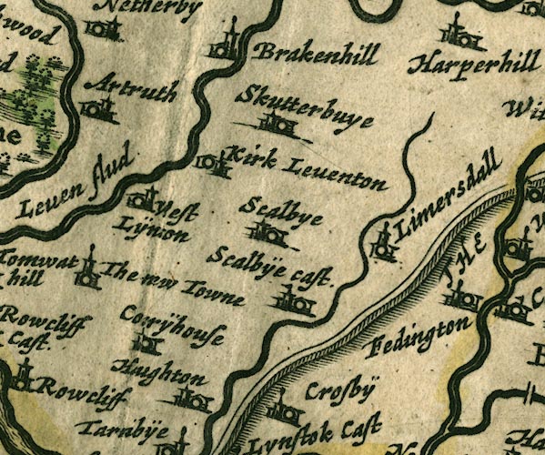 JAN3NY46.jpg
 |
Arthuret -- locality -- NY46 (roughly) ?
-- 'Artruth' -- Buildings and tower.
Brackenhill Tower -- tower -- NY445694 ? ? -- 'Brakenhill' -- Buildings and tower. Corry House -- building/s -- NY492562 -- 'Corrÿhouse' -- Buildings and tower. probably Hadrian's Wall -- roman wall -- roman site -- NY6166 (etc) -- 'THE PICTS WAL.' -- 'THE PICTS WAL.' -- Drawn as a squarely built wall; from Bowness on Solway, through Carlisle, then north and east into Northumberland. Houghton -- building/s -- NY4059 -- 'Haughton' -- Buildings and tower. Irthington -- building/s -- NY4961 -- 'Fedington' -- Buildings and tower. Kirklinton -- building/s -- NY432670 -- 'Kirk Leventon' -- Buildings and tower. Laversdale -- building/s -- NY475625 -- 'Limersdall' -- Buildings and tower. Low Crosby -- building/s -- NY446595 -- 'Crosbÿe' -- Buildings and tower. Newtown of Rockcliffe -- building/s -- NY389625 -- 'The new Towne' -- Buildings and tower. Scaleby Castle -- castle -- NY449624 -- 'Scalbÿe cast.' -- Buildings and tower with flag. Scaleby -- building/s -- NY4463 -- 'Scalbye' -- Buildings and tower. Skitby -- building/s -- NY448657 -- 'Skutterbuye' -- Buildings and tower. Westlinton -- building/s -- NY393645 -- 'West Lÿnton' -- Buildings and tower. | |
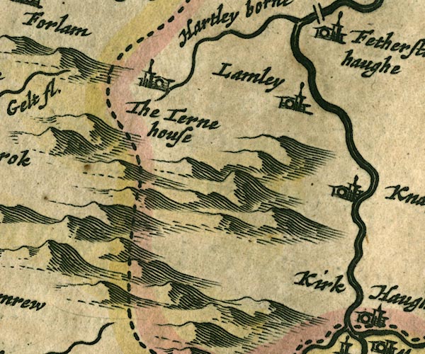
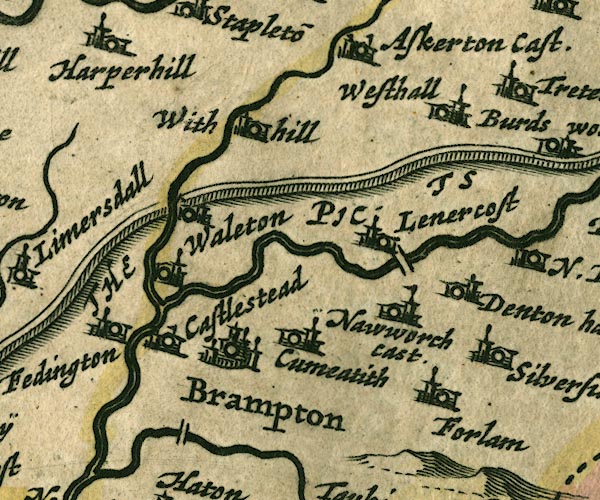 JAN3NY56.jpg
 |
Brampton -- building/s -- NY530611
-- 'Brampton' -- Buildings and towers, suggestion of a
wall, notice ?fence palings; upright lowercase text; market
town.
Cam Beck -- river -- NY5469 (etc) -- 'Cambek fl.' -- Single wiggly line. Castlesteads -- building/s -- NY511633 ? -- 'Castlestead' -- Buildings and tower with flag. Cumcatch -- building/s -- NY547611 -- 'Cumeatith' -- Buildings and tower. Denton Hall -- building/s -- NY578630 -- 'Denton hall' -- Buildings and tower. Farlam -- building/s -- NY5558 -- 'Forlam' -- Buildings and tower. Hadrian's Wall -- roman wall -- roman site -- NY6166 (etc) -- 'THE PICTS WAL.' -- 'THE PICTS WAL.' -- Drawn as a squarely built wall; from Bowness on Solway, through Carlisle, then north and east into Northumberland. Irthing, River -- river -- boundary -- county boundary -- NY4758 (etc etc) -- 'Ireingh fl.' -- Double wiggly line, tapering to single. Lanercost Bridge -- bridge -- NY55346331 -- Double line crossing the stream. Lanercost -- building/s -- NY554638 -- 'Lenercost' -- Buildings and tower. Low Gelt Bridge -- bridge -- NY51975916 -- Double line crossing the stream. Naworth Castle (?) -- castle -- NY559625 ? -- 'Nawworch cast.' -- Buildings and tower with flag. Walton -- building/s -- NY5264 -- 'Waleton' -- Buildings and tower. West Hall -- building/s -- NY566677 -- 'Westhall' -- Buildings and tower. White Hill -- building/s -- NY536659 -- 'With hill' -- Buildings and tower. | |
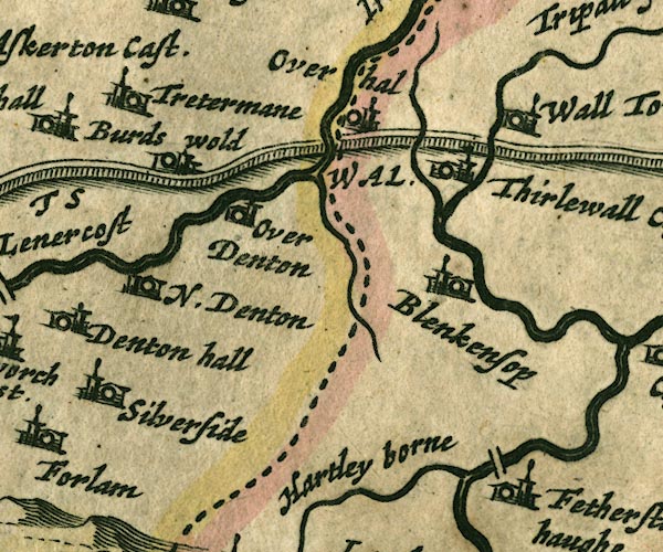 JAN3NY66.jpg
 |
Birdoswald -- building/s -- NY6166
-- 'Burds wold' -- Buildings and tower.
Blenkinsopp Hall -- building/s -- NY681641 ? -- 'Blenkensop' -- Buildings and tower. bridge, Bridge End -- bridge -- NY675619 -- Double line crossing the stream. Featherstone -- locality -- NY6760 -- 'Fetherston haughe' -- Buildings and tower. Hadrian's Wall -- roman wall -- roman site -- NY6166 (etc) -- 'THE PICTS WAL.' -- 'THE PICTS WAL.' -- Drawn as a squarely built wall; from Bowness on Solway, through Carlisle, then north and east into Northumberland. Hartley Burn -- river -- NY6760 -- 'Hartley borne' -- Single wiggly line. Irthing, River -- river -- boundary -- county boundary -- NY4758 (etc etc) -- 'Ireingh fl.' -- Double wiggly line, tapering to single. Nether Denton -- locality -- NY5964 (?) -- 'N. Denton' -- Buildings and tower. Over Hall (?) -- building/s -- house -- NY6367 (roughly) -- 'Overhal' -- Buildings and tower. probably Poltross Burn -- river -- boundary -- county boundary -- NY634664 -- Single wiggly line; county boundary. Pow Charney Burn -- river -- NY6566 (etc) -- Single wiggly line. Silver Side -- building/s -- NY577607 -- 'Silverside' -- Buildings and tower. Thirlwall Castle -- castle -- NY659661 -- 'Thirlewall Cast.' -- Buildings and tower with flag. Triermain -- building/s -- NY593667 -- 'Tretermane' -- Buildings and tower. Upper Denton -- building/s -- NY616654 ? -- 'Over Denton' -- Buildings and tower. Walltown -- building/s etc -- NY679665 -- 'Wall towne' -- Buildings and tower. | |
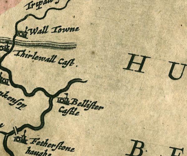 JAN3NY76.jpg
 |
Bellister Castle -- castle -- NY701629
-- 'Bellister Castle' -- Buildings and tower with flag.
South Tyne, River -- river etc -- NY7441 (etc) ? -- Double wiggly line, tapering to single. | |
 JAN3NY15.jpg
 |
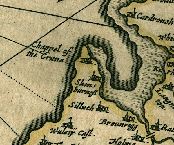
Brownrigg -- building/s -- NY1652
-- 'Brounrigg' -- Buildings and tower.
Cardurnock -- building/s -- NY1758 -- 'Cardronok' -- Buildings and tower. Chappel of ye Grune -- chapel (gone) -- church -- NY1456 -- 'Chappel of the Grune' -- Building, with a cross. Moricambe -- bay -- foreshore -- NY1656 (etc) Silloth -- building/s -- NY1153 -- 'Silluth' -- Buildings and tower. Skinburness -- building/s -- NY1255 -- 'Skinburness' -- Buildings and tower. Wolsty Castle (?) -- castle -- NY1050 -- 'Wulstÿ Cast.' -- Buildings and tower with flag. | |
 JAN3NY25.jpg
 |
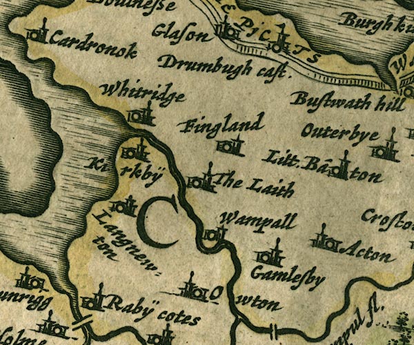
Aikton -- building/s -- NY2753
-- 'Acton' -- Buildings and tower.
Drumburgh Castle -- castle -- NY2659 -- 'Drumbugh cast' -- Buildings and tower with flag. Fingland -- building/s -- NY2557 -- 'Fingland' -- Buildings and tower. Gamelsby -- building/s -- NY2552 -- 'Gamelsby' -- Buildings and tower. Hadrian's Wall -- roman wall -- roman site -- NY6166 (etc) -- 'THE PICTS WAL.' -- 'THE PICTS WAL.' -- Drawn as a squarely built wall; from Bowness on Solway, through Carlisle, then north and east into Northumberland. Kirkbride -- building/s -- NY229568 -- 'Kirkbÿ' -- Buildings and tower. Laythes -- building/s -- NY2455 -- 'The Laith' -- Buildings and tower. Little Bampton -- building/s -- NY2755 -- 'Litt. Ba~ton' -- Buildings and tower. Newton Arlosh -- building/s -- NY1955 -- 'Langnewton' -- Buildings and tower. Oulton -- building/s -- NY248507 -- 'Owton' -- Buildings and tower. Raby Cote -- building/s -- NY1752 -- 'Rabÿ Cotes' -- Buildings and tower. Wampool -- building/s -- NY2454 -- 'Wampall' -- Buildings and tower. Whitrigg -- building/s -- NY2257 -- 'Whitridge' -- Buildings and tower. | |
 JAN3NY35.jpg
 |
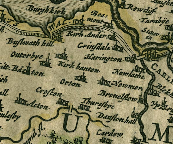
Beaumont -- building/s -- NY3459
-- 'Beamont' -- Buildings and tower.
Boustead Hill -- building/s -- NY2959 -- 'Bustwath hill' -- Buildings and tower. Brownelson -- building/s -- NY385522 -- 'Bronelstow' -- Buildings and tower. Burgh by Sands -- building/s -- NY323591 -- 'Burgh kirk' -- Buildings and tower. Caldew Bridge -- bridge -- NY395560 -- Double line crossing the stream. Crofton Bridge -- bridge -- NY308494 -- Double line crossing the stream. Crofton -- NY3050 -- 'Croston' -- Buildings and tower. Dalston Hall -- building/s -- NY3751 -- 'Dauston hall' -- Buildings and tower. Eden, River -- river etc -- NY3658 (etc) -- 'Eden flude' -- 'Eden flu.' -- 'Eden flud' -- Double line with stream lines, tapering to single line; county boundary for a short stretch. Great Orton -- building/s -- NY3254 -- 'Orton' -- Buildings and tower. Grinsdale -- building/s -- NY3658 -- 'Grinsdale' -- Buildings and tower. Hadrian's Wall -- roman wall -- roman site -- NY6166 (etc) -- 'THE PICTS WAL.' -- 'THE PICTS WAL.' -- Drawn as a squarely built wall; from Bowness on Solway, through Carlisle, then north and east into Northumberland. Harington (?) -- building/s -- locality -- NY3956 -- 'Harington' -- Buildings and tower. probably Kirkandrews upon Eden -- building/s -- NY3558 -- 'Kirk Ander' -- Buildings and tower. Kirkbampton -- building/s -- NY3056 -- 'Kirk banton' -- Buildings and tower. Newby West -- building/s -- NY3653 ? ? -- 'Newmor[e]' -- Buildings and tower. probably Newlaiths Hall -- building/s -- NY385545 -- 'Newlathe[s]' -- Buildings and tower. probably Oughterby -- building/s -- NY2955 -- 'Outerbye' -- Buildings and tower. Thursby -- building/s -- NY3250 -- 'Thuresbÿe' -- Buildings and tower. | |
 JAN3NY45.jpg
 |
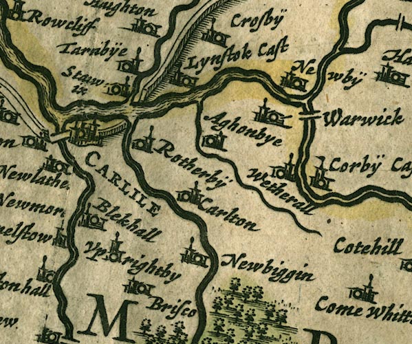
Aglionby -- building/s -- NY4456
-- 'Aghonbye' -- Buildings and tower.
Blackwell Hall -- building/s -- house -- NY398529 ? -- 'Blekhall' -- Buildings and tower. Botcherby -- building/s -- NY4155 -- 'Rotherbÿ' -- Buildings and tower. Brunstock Beck -- river -- NY4261 -- Single wiggly line. Caldew, River -- river etc -- NY3851 (etc) ? -- 'Canda fl.' -- Double wiggly line, tapering to single. Carleton -- building/s -- NY428528 -- 'Carlton' -- Buildings and tower. Carlisle -- building/s -- roman site -- NY403558 -- 'CARLILE' -- Buildings and towers, suggestion of a wall, notice ?fence palings; labelled in upright block caps; market town. Corby Castle -- castle -- garden -- NY4754 -- 'Corbÿ Cast' -- Buildings and tower with flag. Eden, River -- river etc -- NY3658 (etc) -- 'Eden flude' -- 'Eden flu.' -- 'Eden flud' -- Double line with stream lines, tapering to single line; county boundary for a short stretch. Hadrian's Wall -- roman wall -- roman site -- NY6166 (etc) -- 'THE PICTS WAL.' -- 'THE PICTS WAL.' -- Drawn as a squarely built wall; from Bowness on Solway, through Carlisle, then north and east into Northumberland. Irthing, River -- river -- boundary -- county boundary -- NY4758 (etc etc) -- 'Ireingh fl.' -- Double wiggly line, tapering to single. Linstock Castle -- castle -- peel -- NY429584 -- 'Lynstok Cast' -- Buildings and tower with flag. Newbiggin House -- building/s -- NY433509 -- 'Newbiggin' -- Buildings and tower. Newby East -- building/s -- NY475581 -- 'Newbÿ' -- Buildings and tower. Petteril, River -- river -- NY4935 (etc etc) -- 'Pettevell fl.' -- Double wiggly line, tapering to single. Pow Maughan -- river -- NY4552 (etc etc) -- Single wiggly line. Stanwix -- building/s -- locality -- NY3957 -- 'Sta[]wix' -- Buildings and tower. Tarraby -- building/s -- NY409581 -- 'Tarnbÿe' -- Buildings and tower. Upperby -- building/s -- NY4053 ? -- 'Uprightby' -- Buildings and tower. Warwick Bridge -- bridge -- NY46915671 -- Double line crossing the stream. Warwick -- building/s -- NY465566 -- 'Warwick' -- Buildings and tower. Wetheral -- building/s -- NY4654 -- 'Wetherall' -- Buildings and tower. | |
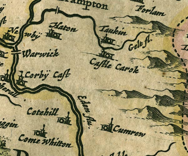 JAN3NY55.jpg
 |
Castle Carrock -- building/s -- NY5455
-- 'Castle Carok' -- Buildings and tower.
Cote Hill -- building/s -- NY508561 -- 'Cotehill' -- Buildings and tower. Cumrew -- building/s -- NY5450 -- 'Cumrew' -- Buildings and tower. Cumwhitton -- building/s -- NY5052 -- 'Come Whitton' -- Buildings and tower. Eden, River -- river etc -- NY3658 (etc) -- 'Eden flude' -- 'Eden flu.' -- 'Eden flud' -- Double line with stream lines, tapering to single line; county boundary for a short stretch. Gelt, River -- river -- NY5456 (etc) ? -- 'Gelt fl.' -- Single wiggly line. Hayton -- building/s -- NY5057 ? -- 'Haton' -- Buildings and tower. Talkin -- building/s -- NY549573 -- 'Taukin' -- Buildings and tower. | |
 JAN3NY65.jpg
 |
Lambley -- building/s -- NY6758
-- 'Lamley' -- Buildings and tower.
South Tyne, River -- river etc -- NY7441 (etc) ? -- Double wiggly line, tapering to single. Tarn House -- building/s -- NY605584 -- 'The Terne house' -- Buildings and tower. | |
 JAN3NY04.jpg
 |
Allonby -- building/s -- NY0843
-- 'Allonbÿe' -- Buildings and tower.
Seacroft Fram -- building/s -- NY077450 -- 'Dubmill' -- Buildings and tower. | |
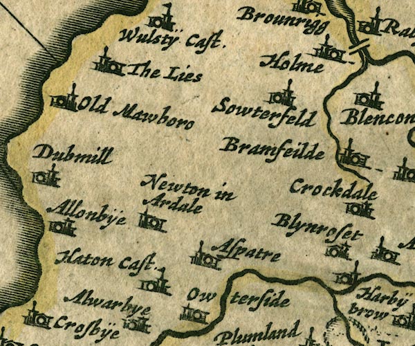 JAN3NY14.jpg
 |
Aspatria -- building/s -- NY1441
-- 'Aspatre' -- Buildings and tower.
Blennerhasset -- building/s -- NY1741 -- 'Blynroset' -- Buildings and tower. Bromfield -- building/s -- NY1746 -- 'Bramfeilde' -- Buildings and tower. Hayton Castle -- castle -- NY1041 -- 'Haton Cast.' -- Buildings and tower with flag. Holme Coultram Abbey -- abbey (site) -- religious house -- NY177509 -- 'Holme' -- Buildings and tower. Lowsay -- building/s -- NY1148 ? -- 'The Lies' -- Buildings and tower. Mawbray -- building/s -- NY0846 -- 'Old Mawboro' -- Buildings and tower. Oughterside -- building/s -- NY1140 -- 'Owterside' -- Buildings and tower. Southerfield -- building/s -- NY1648 -- 'Sowterfeld' -- Buildings and tower. Westnewton -- building/s -- NY1344 -- 'Newton in Ardale' -- Buildings and tower. | |
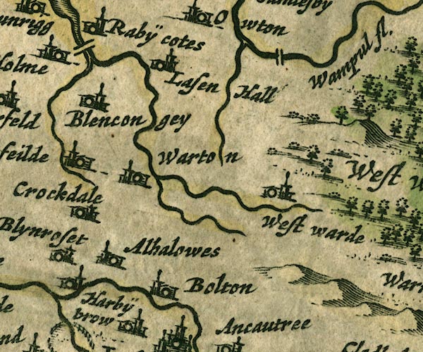 JAN3NY24.jpg
 |
Allhallows -- locality -- NY1842
-- 'Alhalowes' -- Buildings and tower.
Blencogo -- building/s -- NY1947 -- 'Blencongey' -- Buildings and tower. Boltongate -- building/s -- NY229407 -- 'Bolton' -- Buildings and tower. bridge, Holme Abbey -- bridge -- NY184514 -- Double line crossing the stream. bridge, Woodside -- bridge -- NY279499 -- Double line crossing the stream. Crookdake Hall -- building/s -- NY1944 -- 'Crockdake' -- Buildings and tower. Crummock Beck -- river -- NY1846 (etc) ? ? -- Single wiggly line. perhaps Harbybrow -- building/s -- NY1941 -- 'Harbÿbrow' -- Buildings and tower. Lessonhall -- building/s -- NY2250 -- 'Lasen Hall' -- Buildings and tower. Little Waver -- river -- NY2343 (etc) -- Single wiggly line. Wampool, River -- river etc -- NY2453 (etc) ? -- 'Wampul fl.' -- Double wiggly line, tapering to single. Waver, River -- river etc -- NY2344 (etc) -- Single wiggly line. Waverton -- building/s -- NY2247 ? ? -- 'Warton' -- Buildings and tower. Westward -- building/s -- NY2744 -- 'West warde' -- Buildings and tower. Wiza Beck -- river -- NY2745 (etc) -- Single wiggly line. | |
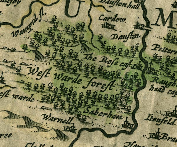 JAN3NY34.jpg
 |
bridge, Dalston -- bridge -- NY370487 ?
-- Double line crossing the stream.
Caldew, River -- river etc -- NY3851 (etc) ? -- 'Canda fl.' -- Double wiggly line, tapering to single. Cardew -- building/s -- NY3449 -- 'Cardew' -- Buildings and tower. Dalston -- building/s -- NY369501 -- 'Dauston' -- Buildings and tower. Rose Castle -- bishop's palace -- palace -- castle -- NY3746 -- 'The Rose cast' -- Buildings and tower, no flag. Sebergham -- building/s -- NY357418 -- 'Saberham' -- Buildings and tower. Warnell -- building/s -- NY3441 -- 'Warnell' -- Buildings and tower. Westward Forest (?) -- forest -- NY34 (?) -- 'West Warde forest' -- Large group of tree symbols. probably | |
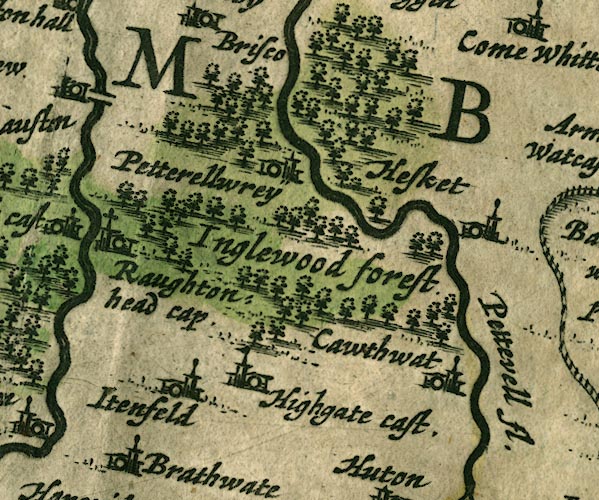 JAN3NY44.jpg
 |
Calthwaite -- building/s -- NY469401
-- 'Cawthwat' -- Buildings and tower.
High Head Castle -- castle -- NY40214339 ? ? -- 'Highgate cast.' -- Buildings and tower with flag. High Hesket -- building/s -- NY476445 ? -- 'Hesket' -- Buildings and tower. Inglewood Forest -- forest -- 'Inglewood forest' -- Group of tree symbols. Itonfield -- locality -- NY426432 ? -- 'Itenfeld' -- Buildings and tower. Petteril, River -- river -- NY4935 (etc etc) -- 'Pettevell fl.' -- Double wiggly line, tapering to single. Raughton Head -- building/s -- NY3845 -- 'Raughtonhead cap' -- Building and tower with cross. Wreay -- building/s -- NY435489 ? -- 'Petterellwrey' -- Buildings and tower. | |
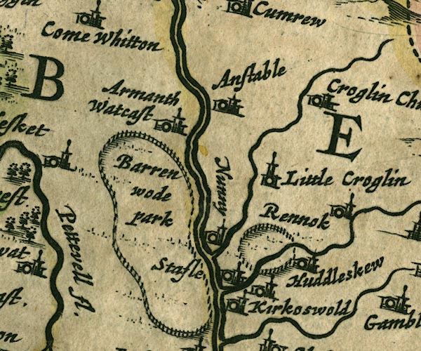 JAN3NY54.jpg
 |
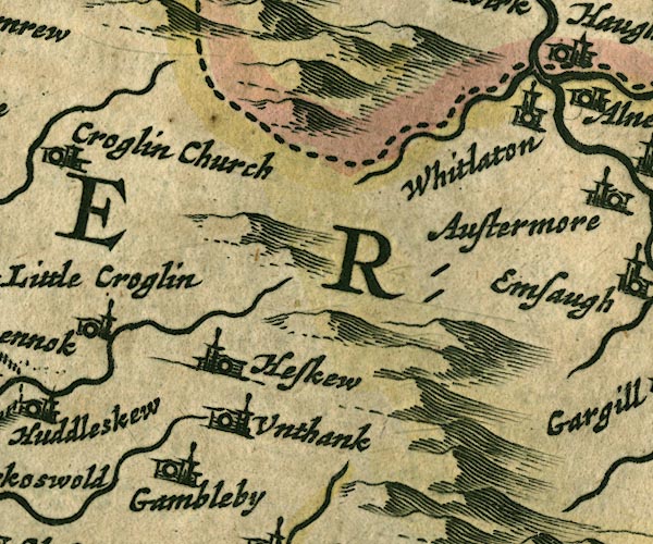
Ainstable -- building/s -- NY5346
-- 'Anstable' -- Buildings and tower.
Armathwaite Place -- building/s -- peel -- castle -- NY50584589 -- 'Armanth Watcast' -- Buildings and tower, no flag. Baronwood Park -- park -- NY5241 -- 'Barren wode park' -- Ring of fence palings. Croglin Low Hall -- building/s -- NY554450 ? ? -- 'Little Croglin' -- Buildings and tower. probably Croglin Water -- river -- NY5746 (etc) -- Single wiggly line. Eden, River -- river etc -- NY3658 (etc) -- 'Eden flude' -- 'Eden flu.' -- 'Eden flud' -- Double line with stream lines, tapering to single line; county boundary for a short stretch. Huddlesceugh Hall -- building/s -- NY597422 ? -- Buildings and tower. Kirkoswald Castle -- castle -- park (?) -- NY559410 -- '[Kirkoswold]' -- Buildings and tower, no flag; the label belongs to the village close by; and a ring of fence palings nearby. Kirkoswald -- building/s -- NY5541 -- 'Kirkoswold' -- Buildings and tower. Nunnery -- building/s -- NY537428 -- 'Nunny' -- Buildings and tower. Raven Beck -- river -- NY5942 (etc) -- Single wiggly line. Renwick -- building/s -- NY597435 -- 'Rennok' -- Buildings and tower. St John's Church -- church -- NY57464726 -- 'Croglin Church' -- Buildings and tower. Staffield -- building/s -- NY542428 -- 'Stafle' -- Buildings and tower. | |
 JAN3NY64.jpg
 |
Gamblesby -- building/s -- NY609393
-- 'Gamleby' -- Buildings and tower.
Gilderdale Burn -- river -- county boundary -- boundary -- NY704489 -- Single wiggly line. Haresceugh -- building/s -- NY609428 -- 'Heskew' -- Buildings and tower. Unthank -- building/s -- NY609404 -- 'Unthank' -- Buildings and tower. Whitley (?) -- locality -- NY7048 (approx) -- 'Whitlaton' -- Buildings and tower. | |
 JAN3NY74.jpg
 |
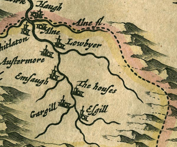
Alston -- building/s -- NY719465
-- 'Austermore' -- Buildings and tower.
Ash Gill -- river -- NY7540 (etc) -- Single wiggly line. Ashgillside -- building/s -- NY7540 ? ? -- 'Esgill' -- Buildings and tower. Ayle Burn -- river -- boundary -- county boundary -- NY7149 -- 'Alne fl.' -- Single wiggly line. Black Burn -- river -- NY6841 -- Single wiggly line. Cross Gill -- river -- NY7440 (etc) -- Single wiggly line. Garrigill -- building/s -- NY744415 ? -- 'Gargill' -- Buildings and tower. Low Ameshaugh -- building/s -- NY711439 -- 'Emsaugh' -- Buildings and tower. Low Byre (?) -- building/s -- NY721476 (roughly) -- 'Lowbyer' -- Buildings and tower. Low Houses -- building/s -- NY742420 ? ? ? -- 'The houses' -- Buildings and tower. Middle Houses -- building/s -- NY743421 ? ? ? -- 'The houses' -- Buildings and tower. Nent, River -- river -- NY7446 (etc etc) -- Single wiggly line. South Tyne, River -- river etc -- NY7441 (etc) ? -- Double wiggly line, tapering to single. | |
 JAN3NY03.jpg
 |
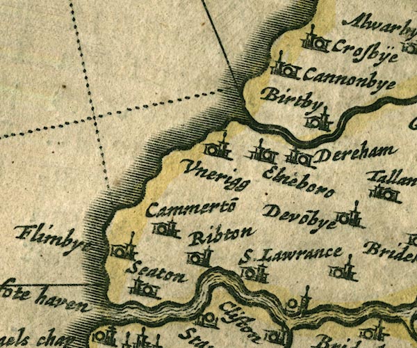
Birkby -- building/s -- NY0637
-- 'Birtby' -- Buildings and tower.
Camerton -- NY03 ? -- 'Cammerto~' -- Buildings and tower. Crosby -- building/s -- NY0738 ? -- 'Crosbÿe' -- Buildings and tower. Crosscanonby -- building/s -- NY0738 ? -- 'Cannonbye' -- Buildings and tower. Dearham -- building/s -- NY0736 -- 'Dereham' -- Buildings and tower. Derwent, River -- river etc -- NY2515 (etc) ? -- 'Darwen fl.' -- Double line with stream lines, tapering to a single line. Dovenby -- building/s -- NY0933 -- 'Devo~bye' -- Buildings and tower. Ellen, River -- river etc -- NY2436 (etc) -- Double wiggly line, tapering to single. Ellenborough -- building/s -- NY0435 -- 'Elneboro' -- Buildings and tower. Ewanrigg Hall -- building/s -- NY0435 -- 'Unerigg' -- Buildings and tower. Flimby Station -- railway station -- station -- NY021338 -- 'Flimbye' -- Buildings and tower. Great Broughton -- building/s -- NY0731 -- Buildings and tower. Port of Workington -- harbour -- NX9929 -- 'Derwenfote haven' -- Label at the Derwent mouth. Ribton Hall -- building/s -- NY0430 ? -- 'Ribton' -- Buildings and tower. Seaton -- building/s etc -- NY0130 -- 'Seaton' -- Buildings and tower. St Lawrence Chapel -- church -- chapel -- NY060304 -- 'S. Lawrance' -- Buildings and tower. | |
 JAN3NY13.jpg
 |
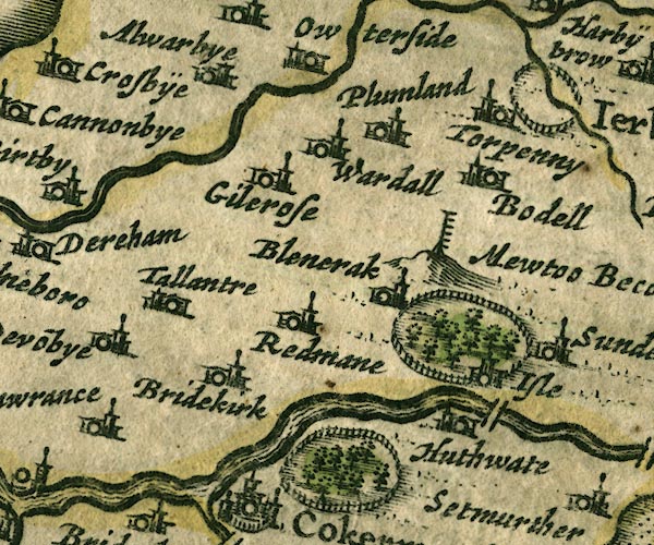
Allerby -- building/s -- NY0839
-- 'Alwarbye' -- Buildings and tower.
Mewton Beacon -- beacon -- -- 'Mewtoo Becon' -- Tall post with ladder rungs etc, on a hillock. Blindcrake -- building/s -- NY1434 -- 'Blencrak' -- Buildings and tower. Bothel -- building/s -- NY1838 -- 'Bodel' -- Buildings and tower. Bridekirk -- building/s -- NY1133 -- 'Bridekirk' -- Buildings and tower. Derwent, River -- river etc -- NY2515 (etc) ? -- 'Darwen fl.' -- Double line with stream lines, tapering to a single line. Gilcrux -- building/s -- NY1138 -- 'Gilcross' -- Buildings and tower. Hewthwaite Hall -- building/s -- NY152328 -- 'Huthwate' -- Buildings and tower. Isel Bridge -- bridge -- NY16413331 -- Double line crossing the stream. Isel Park -- park -- NY1534 -- Ring of fence palings with trees. Isel -- locality -- NY1633 -- 'Isle' -- Buildings and tower. Moota Hill -- hill -- NY1436 -- 'Mewtoo Becon' -- Hillock, with beacon. park, Cockermouth -- park -- NY1331 -- Ring of fence palings with trees. Plumbland -- building/s -- NY1539 -- 'Plumland' -- Buildings and tower. Redmain -- building/s -- NY1333 -- 'Redmane' -- Buildings and tower. Tallentire -- building/s -- NY1035 -- 'Tallantre' -- Buildings and tower. Torpenhow -- building/s -- NY2039 -- 'Torpenny' -- Buildings and tower. Wardhall Guards -- building/s -- NY1338 -- 'Wardall' -- Buildings and tower. | |
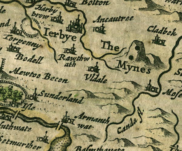 JAN3NY23.jpg
 |
Armathwaite Hall -- building/s -- hotel -- NY207325
-- 'Armanthwat' -- Buildings and tower.
Aughertree -- building/s -- NY2538 -- 'Ancautree' -- Buildings and tower. Caldew, River -- river etc -- NY3851 (etc) ? -- 'Canda fl.' -- Double wiggly line, tapering to single. Cockshot Beck -- river -- NY20704061 -- Single wiggly line. Derwent, River -- river etc -- NY2515 (etc) ? -- 'Darwen fl.' -- Double line with stream lines, tapering to a single line. Ireby -- building/s etc -- NY238388 -- 'Ierbye' -- Buildings and towers, suggestion of a wall, notice ?fence palings; upright lowercase text; market town. Ouse Bridge -- bridge -- NY199321 -- Double line crossing the stream. park, Ireby -- park -- NY212402 -- Ring of fence palings. Roughtongill Mines -- copper mine -- lead mine -- mine -- zinc mine -- mine -- NY298339 & NY309345 -- 'The Mynes' -- Two black spots drawn on the hillock. Ruthwaite -- building/s -- NY237367 -- 'Rawthwath' -- Buildings and tower. Sunderland -- building/s -- NY1735 -- 'Sunderland' -- Buildings and tower. Uldale -- building/s -- NY2436 -- 'Uldale' -- Buildings and tower. | |
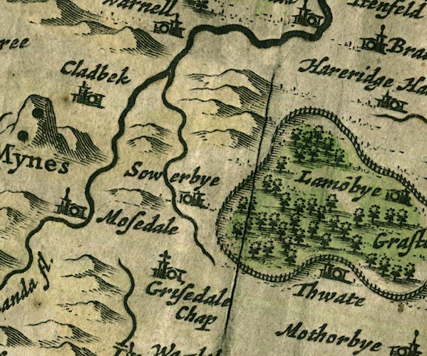 JAN3NY33.jpg
 |
Caldbeck -- building/s -- NY3239
-- 'Cladbek' -- Buildings and tower.
Caldew, River -- river etc -- NY3851 (etc) ? -- 'Canda fl.' -- Double wiggly line, tapering to single. Gillcambon Beck -- river -- NY3835 (etc) -- Single wiggly line. Greenthwaite Hall -- building/s -- NY43153021 -- 'Thwate' -- Buildings and tower. Greystoke Castle -- castle -- park -- NY425309 (castle) -- 'Graystok cast.' -- Buildings and tower with flag in a ring of fence palings with trees. Greystoke Forest -- wood -- forest -- NY3933 (etc) -- Group of tree symbols, in the park. Mosedale -- building/s -- NY356322 (etc) ? -- 'Mosedale' -- Buildings and tower. Sowerby Hall -- building/s -- NY3836 -- 'Sowerbye' -- Buildings and tower. St Kentigern's Church -- church -- NY36353043 -- 'Grisedale Chap' -- Building and tower with cross. | |
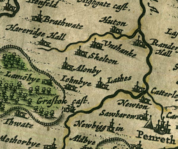 JAN3NY43.jpg
 |
Ellonby -- building/s -- NY425354
-- 'Alonby' -- Buildings and tower.
Greystoke Castle -- castle -- park -- NY425309 (castle) -- 'Graystok cast.' -- Buildings and tower with flag in a ring of fence palings with trees. Hardrigg Hall -- building/s -- NY425362 -- 'Hareridge Hall' -- Buildings and tower. Hutton-in-the-Forest -- building/s -- garden (?) -- NY460358 -- 'Huton' -- Buildings and tower. Johnby -- building/s -- NY432331 -- 'Iohnbye' -- Buildings and tower. Laithes -- building/s -- NY464329 -- 'Lathes' -- Buildings and tower. Lamonby -- building/s -- NY409358 -- 'Lamo~nbye' -- Buildings and tower. Low Braithwaite -- building/s -- NY426422 -- 'Brathwate' -- Buildings and tower. Newbiggin -- building/s -- NY4629 -- 'Newbiggin' -- Buildings and tower. Newton Reigny -- building/s -- NY4731 -- 'Newton' -- Buildings and tower. Old Petterill -- river -- NY48983692 -- Double wiggly line, tapering to single. Petteril, River -- river -- NY4935 (etc etc) -- 'Pettevell fl.' -- Double wiggly line, tapering to single. Randerside Hall (?) -- building/s -- house -- NY4836 ? -- 'Randersid Hall' -- Buildings and tower. Sewborwens -- building/s -- NY491302 -- 'Sawbarow' -- Buildings and tower. Skelton -- building/s -- NY4335 -- 'Skelton' -- Buildings and tower. Unthank -- building/s -- NY452362 -- 'Unthanke' -- Buildings and tower. | |
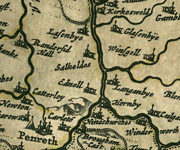 JAN3NY53.jpg
 |
battle site, Penrith -- battle site -- NY5130 (??)
-- 'Penreth' -- Tent symbol.
Briggle Beck -- river -- NY5833 (etc) -- Double wiggly line, tapering to single. Brougham Castle -- castle -- NY537290 ? -- 'Brougham Cast.' -- Buildings and tower with flag. Carleton -- building/s -- NY5329 -- 'Carleto~' -- Buildings and tower. Eamont, River -- river etc -- NY469243 (from) ? ? -- Double wiggly line, tapering to single; county boundary. Eden, River -- river etc -- NY3658 (etc) -- 'Eden flude' -- 'Eden flu.' -- 'Eden flud' -- Double line with stream lines, tapering to single line; county boundary for a short stretch. Edenhall -- building/s -- NY565324 -- 'Ednell' -- Buildings and tower. Glassonby -- building/s -- NY576388 -- 'Glasenbÿe' -- Buildings and tower. Great Salkeld -- building/s -- NY5536 -- 'Salkeldes' -- Buildings and tower. Hazelrigg Beck -- river -- NY6040 (etc) -- Single wiggly line. Hornby Hall -- building/s -- NY5629 ? ? -- 'Hornby' -- Buildings and tower. Langwathby -- building/s -- NY5633 -- 'Langanbye' -- Buildings and tower. Lazonby -- building/s -- NY5439 -- 'Lasenbye' -- Buildings and tower. Little Salkeld -- building/s -- NY566361 -- 'Salkeldes' -- Buildings and tower. Penrith -- building/s etc -- NY513304 -- 'Penreth' -- Buildings and towers, suggestion of a wall, notice ?fence palings, suggestion of a wall, notice ?fence palings; upright lowercase text; market town. Robberby Water -- river -- NY561359 -- Single wiggly line. St Ninian's Church -- church -- NY55932995 -- 'Ninechurches' -- Building and tower. Thacka Beck -- river -- NY49173297 -- Single wiggly line. Winderwath -- building/s -- NY597294 -- 'Winderworth' -- Buildings and tower. Winskill -- building/s -- NY580349 -- 'Winsgell' -- Buildings and tower. | |
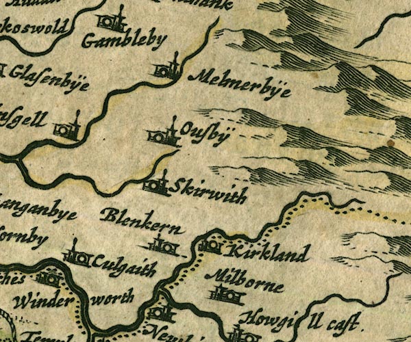 JAN3NY63.jpg
 |
Blencarn -- building/s -- NY6331
-- 'Blenkern' -- Buildings and tower.
Crowdundle Beck -- river -- NY6228 (etc) -- Single wiggly line; county boundary. Culgaith -- building/s -- NY6129 -- 'Culgaith' -- Buildings and tower. Kirkland -- building/s -- NY646325 -- 'Kirkland' -- Buildings and tower. Melmerby -- building/s -- NY615373 -- 'Melmerbÿe' -- Buildings and tower. Milburn Beck -- river -- NY6528 (etc) -- Single wiggly line. Milburn -- building/s -- NY6529 -- 'Milborne' -- Buildings and tower. Ousby -- building/s -- NY621348 -- 'Ousbÿ' -- Buildings and tower. Skirwith Beck -- river -- NY6132 (etc) -- Single wiggly line; rivers on the map are incorrectly drawn here. probably Skirwith -- building/s -- NY6132 -- 'Skirwith' -- Buildings and tower. | |
 JAN3NY73.jpg
 | ||
 JAN3NX92.jpg
 | ||
 JAN3NY02.jpg
 |
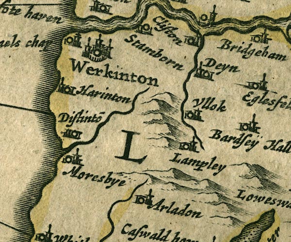
Arlecdon -- building/s -- NY0419
-- 'Arladon' -- Buildings and tower.
Dean -- building/s -- NY0725 -- 'Deyn' -- Buildings and tower. Distington -- building/s -- NY0023 -- 'Distinto~' -- Buildings and tower. Great Clifton -- building/s -- NY0429 ? ? -- 'Cliston' -- Buildings and tower. Harrington -- building/s -- NX9825 -- 'Harinton' -- Buildings and tower. Lamplugh -- building/s -- NY088207 -- 'Lampley' -- Buildings and tower. Lowca Beck -- river -- NX978212 -- Single wiggly line. Marron, River -- river -- NY0624 -- Single wiggly line. Moresby -- building/s -- NX9921 -- 'Moresbye' -- Buildings and tower. St Michael's Church -- church -- NX99722894 ? -- 'S. Michaels chap' -- Building and tower with cross. Stainburn -- building/s -- NY0229 ? -- 'Stamborn' -- Buildings and tower. Ullock -- building/s -- NY0723 -- 'Ullok' -- Buildings and tower. Workington -- building/s -- NX996288 -- 'Werkinton' -- Buildings and towers, suggestion of a wall, notice ?fence palings; upright lowercase text; market town. | |
 JAN3NY12.jpg
 |
Brackenthwaite -- building/s -- NY154221
-- 'Brakentwate' -- Buildings and tower.
Brigham -- building/s -- NY0830 -- 'Bridgeham' -- Buildings and tower. Cocker Bridge -- bridge -- NY12233071 -- Double line crossing the stream. Cocker, River -- river -- NY1426 ? -- 'Coker flu.' -- Double wiggly line, tapering to single. Cockermouth -- building/s etc -- NY122306 -- 'Cokermouth' -- Buildings and towers, suggestion of a wall, notice ?fence palings; upright lowercase text; market town. Eaglesfield -- building/s -- NY0928 -- 'Eglesfeld' -- Buildings and tower. Embleton -- building/s -- NY1730 -- 'Emleton' -- Buildings and tower. High Lorton -- building/s -- NY162257 ? -- 'Lorton' -- Buildings and tower. Loweswater -- building/s -- NY139208 -- 'Loweswater' -- Buildings and tower. Pardshaw Hall -- building/s -- NY10272536 ? -- 'Bardseÿ Hall' -- Buildings and tower. Scalehill Bridge -- bridge -- NY148215 -- Double line crossing the stream. | |
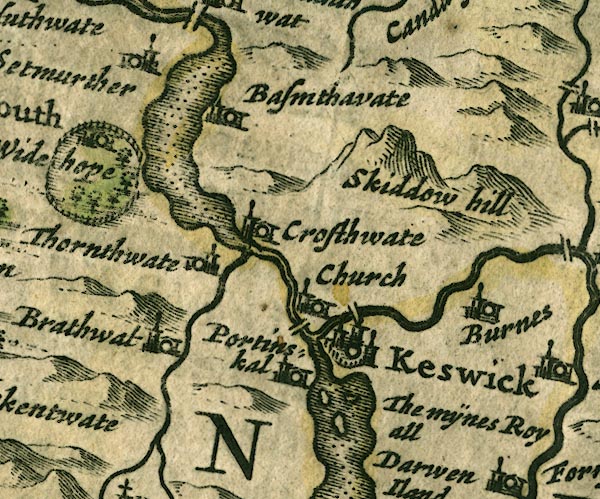 JAN3NY22.jpg
 |
Bassenthwaite Lake -- lake -- NY215298
-- Outline with shore shaded, dotted area.
Bassenthwaite -- building/s -- NY2332 -- 'Bassenthwaite' -- Buildings and tower. Braithwaite -- building/s -- NY231235 -- 'Brathwat' -- Buildings and tower. Burns Farm -- building/s -- NY308242 -- 'Burnes' -- Buildings and tower. Derwent Isle -- island -- NY261224 -- 'The mÿnes Royall / Darwen Iland' -- The label is alongside the lake, where the miners from Germany settled on the island. Derwent Water -- lake etc -- NY260210 ? -- Outline with shore shaded, dotted area. Derwent, River -- river etc -- NY2515 (etc) ? -- 'Darwen fl.' -- Double line with stream lines, tapering to a single line. Great Crosthwaite -- building/s etc -- NY261242 -- 'Crosthwate Church' -- Buildings and tower. Greta Bridge -- bridge -- NY26302374 ? ? -- Double line crossing the stream. Greta, River -- river -- NY2924 -- Double wiggly line, tapering to single. Keswick -- building/s etc -- NY266234 -- 'Keswick' -- Buildings and towers, suggestion of a wall, notice ?fence palings; upright lowercase text; market town. Little Crosthwaite -- building/s -- NY234276 -- 'Crosthwate' -- Buildings and tower. Long Bridge -- footbridge -- bridge -- NY25362377 -- Double line crossing the stream. Newlands Beck -- river -- NY2319 -- Single wiggly line. Portinscale -- building/s -- NY251235 -- 'Portinskal' -- Buildings and tower. Setmurthy -- locality -- NY1832 -- 'Setmurther' -- Buildings and tower. Skiddaw -- hill -- NY260290 -- 'Skiddow hill' -- Large lumpy hillock. Thornthwaite -- building/s -- NY223254 ? -- 'Thornthwate' -- Buildings and tower. Wythop Hall -- building/s -- park -- NY20312844 -- 'Widehope' -- Buildings and tower in a ring of fence palings with trees. | |
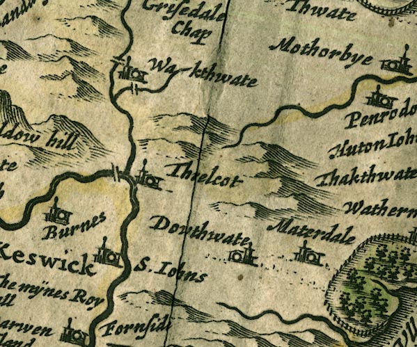 JAN3NY32.jpg
 |
Dowthwaitehead -- building/s -- NY370208 ?
-- 'Dowthwate' -- Buildings and tower.
ford, Wallthwaite -- ford -- NY35322620 (?) ? ? -- Double line crossing the stream. probably Glenderamackin, River -- river -- NY3426 -- Single wiggly line. Lamb Bridge -- bridge -- NY35372676 -- Double line crossing the stream. Matterdale -- locality -- NY3922 (?) -- 'Materdale' -- Buildings and tower. Mosedale Beck -- river -- NY3523 -- Single wiggly line. Petteril, River -- river -- NY4935 (etc etc) -- 'Pettevell fl.' -- Double wiggly line, tapering to single. St John's Beck -- river -- NY3123 ? -- Double wiggly line, tapering to single. St John's in the Vale -- valley -- NY3122 (etc) -- 'S. Iohns' -- Buildings and tower. Threlkeld Bridge -- bridge -- NY31472470 -- Double line crossing the stream. Threlkeld -- building/s -- NY322254 -- 'Threlcot' -- Buildings and tower. Wallthwaite -- building/s -- NY35402624 -- 'Wakthwate' -- Buildings and tower. | |
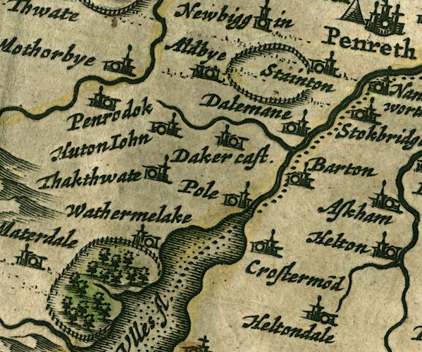 JAN3NY42.jpg
 |
Aldby -- building/s -- NY461277
-- 'Aldbye' -- Buildings and tower.
Barton -- building/s -- NY486264 -- 'Barton' -- Buildings and tower. Collierhagg Beck -- river -- NY41942049 ? ? possibly Cross Dormont -- building/s -- NY46182250 -- 'Crostermo~d' -- Buildings and tower. Dacre Beck -- river -- NY4626 -- Single wiggly line. Dacre Castle -- castle -- NY46052650 -- 'Daker cast.' -- Buildings and tower. Dalemain -- park -- house -- museum -- garden -- NY479269 -- 'Dalemane' -- Buildings and tower in a ring of fence palings. probably Eamont, River -- river etc -- NY469243 (from) ? ? -- Double wiggly line, tapering to single; county boundary. Gowbarrow Park -- park -- NY408212 (etc) -- Ring of fence palings with trees. Hutton John -- park -- house -- tower -- peel -- NY43972696 -- 'Huton Iohn' -- Buildings and tower. Motherby -- building/s -- NY4228 -- 'Mothorbye' -- Buildings and tower. Parkhouse Gill -- river -- NY42592068 ? ? possibly Penruddock -- building/s -- NY429276 -- 'Penrodok' -- Buildings and tower. Petteril, River -- river -- NY4935 (etc etc) -- 'Pettevell fl.' -- Double wiggly line, tapering to single. Pooley Bridge -- building/s etc -- NY472244 -- 'Pole' -- Buildings and tower. Stainton -- building/s -- NY4827 -- 'Stainton' -- Buildings and tower. Thackthwaite -- building/s -- NY423254 -- 'Thakthwate' -- Buildings and tower. Ullswater -- lake -- NY422202 (etc) ? -- 'Ulles fl.' -- Outline with shore shaded, dotted area; the county boundary goes down the middle. Watermillock -- building/s -- NY445224 -- 'Wathermelake' -- Buildings and tower. | |
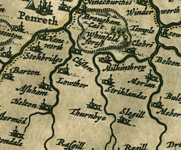 JAN3NY52.jpg
 |
Askham -- building/s -- NY513237
-- 'Askham' -- Buildings and tower.
Cliburn -- building/s -- NY5824 -- 'Clobro~' -- Buildings and tower. Clifton -- building/s -- NY534266 -- 'Cliston' -- Buildings and tower. Eamont, River -- river etc -- NY469243 (from) ? ? -- Double wiggly line, tapering to single; county boundary. Great Strickland -- building/s -- NY5522 ? -- 'Stricklandes' -- Buildings and tower. Helton -- building/s -- NY510220 -- 'Helton' -- Buildings and tower. Heltondale Beck -- river -- NY51522025 -- Single wiggly line. Leith, River -- river -- NY5523 -- Double wiggly line, tapering to single. Lowther -- building/s -- NY536236 -- 'Lowther' -- Buildings and tower. Lowther, River -- river etc -- NY5124 (etc) ? -- Double wiggly line, tapering to single. Melkinthorpe -- building/s -- NY5525 -- 'Milkinthrop' -- Buildings and tower. Morland -- building/s etc -- NY598225 -- 'Morlan' -- Buildings and tower. Sleagill -- building/s -- NY5919 -- 'Slegill' -- Buildings and tower. Sockbridge -- building/s -- NY4926 -- 'Stokbridge' -- Buildings and tower. Thrimby -- building/s -- NY5520 -- 'Thurnbye' -- Buildings and tower. Whinfell Forest -- forest -- wood -- NY5727 (etc) -- 'Whinfeld forest' -- Group of tree symbols within a ring of fence palings. Whinfell Park -- building/s -- NY5528 -- Ring of fence palings with trees which are labelled 'Whinfeld forest'. probably Yanwath -- building/s -- NY5127 -- 'Naneworth' -- Buildings and tower. | |
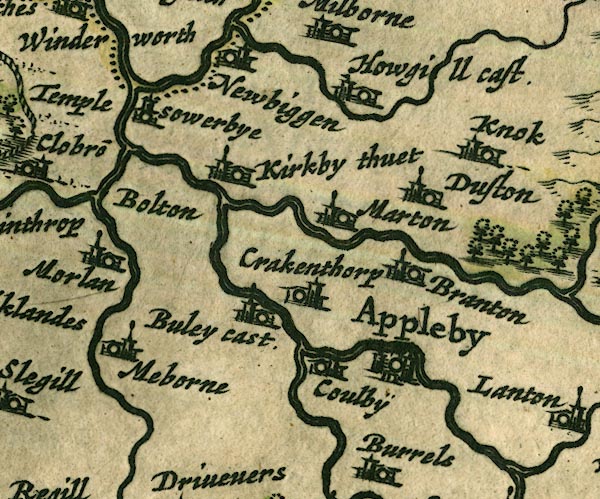 JAN3NY62.jpg
 |
Appleby-in-Westmorland -- building/s etc -- NY684204
-- 'Appleby' -- Buildings and towers, suggestion of a wall,
notice ?fence palings; upright lowercase text; market town.
Bewley Castle -- castle (remains) -- NY64822115 -- 'Buley cast.' -- Buildings and tower, flag not visible. Bolton -- building/s -- NY6323 -- 'Bolton' -- No symbol. Brampton -- building/s -- NY6723 -- 'Branton' -- Buildings and tower. Colby -- building/s -- NY6620 -- 'Coulbÿ' -- Buildings and tower. Crackenthorpe -- building/s -- NY661221 ? -- 'Crakenthorp' -- Buildings and tower. Dufton -- building/s -- NY6825 -- 'Duston' -- Buildings and tower. Eden, River -- river etc -- NY3658 (etc) -- 'Eden flude' -- 'Eden flu.' -- 'Eden flud' -- Double line with stream lines, tapering to single line; county boundary for a short stretch. Hoff Beck -- river -- NY6717 (etc) -- Double wiggly line, tapering to single. Howgill Castle, Milburn Sowerby -- 'Howgill cast.' -- Buildings and tower with flag. King's Meaburn -- building/s -- NY6221 ? -- 'Meborne' -- Buildings and tower. Kirkby Thore -- building/s -- NY638256 -- 'Kirkby thuet' -- Buildings and tower. Knock -- building/s -- NY680270 -- 'Knok' -- Buildings and tower. Long Marton -- building/s -- NY6624 ? -- 'Marton' -- Buildings and tower. Lyvennet, River -- river -- NY6121 (etc) -- Double wiggly line, tapering to single. Newbiggin -- building/s -- NY6228 -- 'Newbiggen' -- Buildings and tower. Temple Sowerby -- building/s -- NY6127 -- 'Temple sowerbye' -- Buildings and tower. Trout Beck -- river -- boundary -- NY6624 (etc) -- Double wiggly line, tapering to single. | |
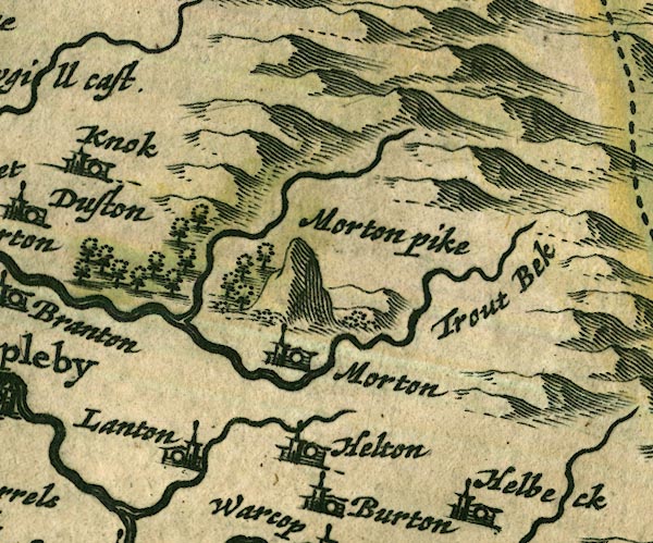 JAN3NY72.jpg
 |
forest, Murton -- wood -- forest -- NY7022 (approx)
-- Group of trees.
High Cup Gill -- river -- boundary -- NY7325 (etc etc) -- Single wiggly line. Hilton Beck -- river -- NY7220 (etc) -- Single wiggly line. Hilton -- building/s -- NY734207 -- 'Helton' -- Buildings and tower. Langton -- building/s -- NY709201 -- 'Lanton' -- Buildings and tower. Murton Beck -- river -- NY7221 -- 'Trout bek' -- Double wiggly line, tapering to single. Murton Pike -- hill -- NY734231 -- 'Morton pike' -- Large hillock. Murton -- building/s -- NY7221 -- 'Morton' -- Buildings and tower. | |
 JAN3NY82.jpg
 | ||
 JAN3NX91.jpg
 |
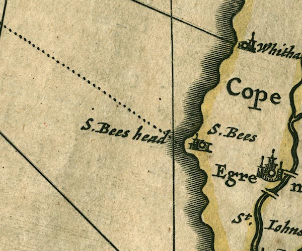
St Bees Head -- headland -- NX940143 (etc)
-- 'S. Bees head' -- Labelling the headland.
St Bees -- building/s -- NX971116 -- 'S. Bees' -- Buildings and tower. | |
 JAN3NY01.jpg
 |
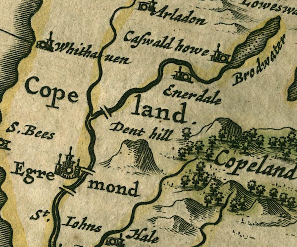
Blackhow Bridge -- bridge -- NY016134
-- Double line crossing the stream. probably
Briscoemill Bridge -- bridge -- NY015116 ? ? -- Double line crossing the stream. probably Dent -- hill -- NY041128 -- 'Dent hill' -- Lumpy hillock. Egremont -- building/s -- NY011105 -- 'Egremond' -- Buildings and towers, suggestion of a wall, notice ?fence palings; upright lowercase text; market town. Ehen, River -- river -- NY0515 (etc) ? -- Double wiggly line, tapering to single. Ennerdale Bridge -- building/s -- NY069159 -- 'Enerdale' -- Buildings and tower. How Hall Farm -- building/s -- NY09021635 -- 'Caswald howe' -- Buildings and tower. Keekle, River -- river -- NY0019 (etc) -- Single wiggly line. Old Bridge (?) -- bridge -- NY010104 -- Double line crossing the stream. Whitehaven -- building/s -- NX974182 -- 'Whithaven' -- Buildings and tower. | |
 JAN3NY11.jpg
 |
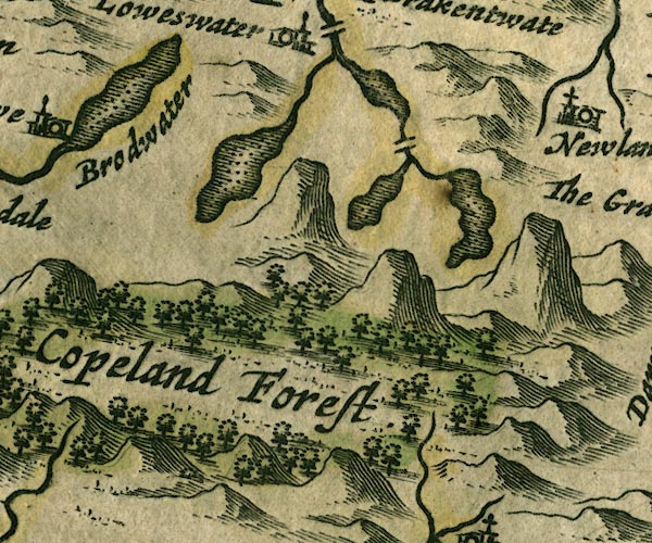
Bleaberry Tarn -- lake -- NY165154 ? ?
-- Outline with shore shaded, dotted area. probably
Buttermere Dubs -- river -- NY167166 (etc) -- Single wiggly line. Buttermere -- lake -- NY182158 -- Outline with shore shaded, dotted area. Copeland Forest -- forest -- NY10 (etc) -- 'Copeland Forest' -- Large group of trees. Crummock Water -- lake -- NY158189 -- Outline with shore shaded, dotted area. Ennerdale Water -- lake -- NY106150 -- 'Brodwater' -- Outline with shore shaded, dotted area. Loweswater -- lake -- NY125217 ? ? -- Outline with shore shaded, dotted area. Park Beck -- river -- NY15162056 -- Single wiggly line. Scale Bridge -- bridge -- NY16801659 ? -- Double line crossing the stream. | |
 JAN3NY21.jpg
 |
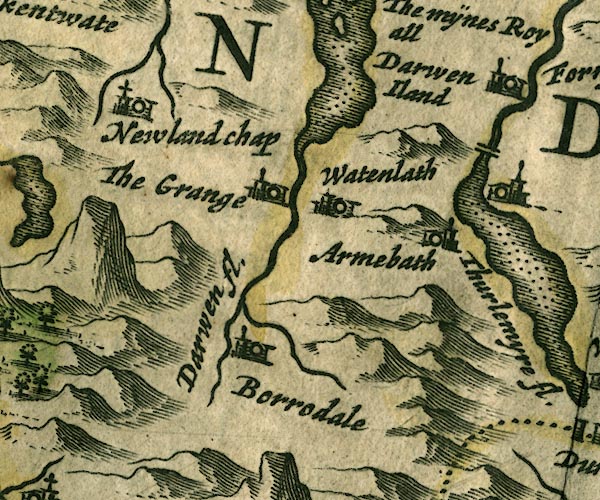
Armboth -- locality -- NY305171
-- 'Armebath' -- Buildings and tower.
Borrowdale -- locality -- valley -- NY2516 (etc) -- 'Borrodale' -- Buildings and tower. Derwent Water -- lake etc -- NY260210 ? -- Outline with shore shaded, dotted area. Derwent, River -- river etc -- NY2515 (etc) ? -- 'Darwen fl.' -- Double line with stream lines, tapering to a single line. Grange -- building/s -- NY252174 -- 'The Grange' -- Buildings and tower. Keskadale Beck -- river -- NY2119 ? -- Single wiggly line. Newlands Church -- chapel -- church -- school (ex) -- NY22981934 -- 'Newland Chap' -- Building and tower with cross. Smaithwaite Bridge -- bridge -- NY31551955 -- Double line crossing the stream; this rather than High Bridge. Stonethwaite Beck -- river -- NY2614 -- Single wiggly line. Watendlath -- building/s -- NY276163 -- 'Watenlath' -- Buildings and tower. | |
 JAN3NY31.jpg
 |
Aira Beck -- river -- NY40001974
-- Single wiggly line.
Dunmail Raise Stones -- cairn -- NY32721167 -- 'Dunbalrase stones' -- Marked by two very square pillars; at county boundary. Fornside -- building/s -- NY320206 -- 'Fornside' -- Buildings and tower. Glencoyne Beck -- river -- boundary -- county boundary -- NY38751881 ? -- 'Glenkwen fl.' -- Single wiggly line; county boundary. Glenridding Beck -- river -- NY35971603 ? -- 'Glenkroden fl.' -- Single wiggly line. Grisedale Beck -- river -- NY36451437 ? -- Single wiggly line. Grisedale Tarn -- lake -- NY348120 ? -- Outline with shore shaded, dotted area. probably Helvellyn -- hill -- NY34261508 -- 'Helvillon hill' -- Just a hillock. Legburthwaite -- building/s -- NY319193 -- Buildings and tower. Thirlmere -- lake -- NY3115 (etc) ? -- 'Thurlemyre fl.' -- Outline with shore shaded, dotted area. Wythburn -- locality -- NY322130 (etc) -- 'Wiborne' -- Buildings and tower. | |
 JAN3NY41.jpg
 |
Deepdale Hall -- building/s -- NY39561412
-- 'Depedale' -- Buildings and tower.
Goldrill Beck -- river -- NY393166 -- Single wiggly line. Hartsop Hall (?) -- building/s -- NY39861202 -- 'Harteshope hall' -- Buildings and tower. probably Heltondale -- building/s -- NY501208 -- 'Heltondale' -- Buildings and tower. Howegrain Beck -- river -- NY44321990 ? -- Single wiggly line. Patterdale -- building/s -- NY394160 -- 'Paterdale' -- Buildings and tower. Rampsgill Beck -- river -- NY4315 -- Single wiggly line. St Martin's Church -- church -- NY43421840 -- 'Markendale Chappell' -- Building and tower with cross. Thornthwaite Hall -- building/s -- NY512163 -- 'Thornehwate' -- Buildings and tower. Ullswater -- lake -- NY422202 (etc) ? -- 'Ulles fl.' -- Outline with shore shaded, dotted area; the county boundary goes down the middle. | |
 JAN3NY51.jpg
 |
Bampton Grange -- building/s -- NY521180 ?
-- 'Banton' -- Buildings and tower.
Birk Beck -- river -- NY5808 -- 'Burbeck fl.' -- Single wiggly line. Harberwain -- building/s -- NY60731504 -- 'Harberwen' -- Buildings and tower. Haweswater Beck -- river -- NY5116 -- Single wiggly line. Maulds Meaburn -- building/s -- NY624168 -- 'Malmeshorne' -- Buildings and tower. Oddendale -- building/s -- NY594134 -- 'Oddelden' -- Buildings and tower. Park -- building/s -- NY612090 -- 'Park' -- Buildings and tower. Reagill -- building/s -- NY603176 -- 'Regill' -- Buildings and tower. Rosgill -- building/s -- NY537167 -- 'Rasgill' -- Buildings and tower. Shap -- building/s etc -- NY562153 -- 'Shapp' -- Buildings and tower. Wasdale Beck -- river -- NY5608 (etc) -- 'Burbeck fl.' -- Buildings and tower. Wasdale Foot (?) -- building/s (gone?) -- NY5709 (?) -- 'Wastall foot' -- Buildings and tower. Wasdale Head -- building/s -- NY55010817 -- 'Wastall head' -- Buildings and tower. Wickerslack -- building/s -- NY608156 -- 'Wickerslack' -- Buildings and tower. | |
 JAN3NY61.jpg
 |
Beacon Hill -- hill -- beacon -- NY6309 ?
-- 'The Beacon' -- Hillock, post with ladder rungs etc.
Burrells -- building/s -- NY6818 -- 'Burrels' -- Buildings and tower. Crosby Ravensworth -- building/s -- NY622148 -- 'Crosbyerawe~swath' -- Buildings and tower. Dry Beck -- river -- NY6615 (etc) -- Single wiggly line. Drybeck -- building/s -- NY665153 -- 'Dribek' -- Buildings and tower. Dryevers -- building/s -- NY645174 -- 'Drivevers' -- Buildings and tower. Gilts -- building/s -- NY626118 ? -- 'Gilse' -- Buildings and tower. Great Asby -- building/s -- NY680131 -- 'G. Ashbÿ' -- Buildings and tower. Great Ormside -- building/s -- NY7017 -- 'Great Ormeside' -- Buildings and tower. Helm Beck -- river -- NY7015 (etc) -- Single wiggly line. Hoff Lunn -- wood -- NY661163 (etc) -- Group of tree symbols. Hoff -- building/s -- NY6717 -- 'Hoffe' -- Buildings and tower. Little Asby -- building/s -- NY698096 -- 'L. Ashby' -- Buildings and tower. Lyvennet Beck -- river -- NY6215 (etc etc) -- Double wiggly line, tapering to single. park, Crosby Ravensworth -- park -- NY6214 -- Ring of fence palings. | |
 JAN3NY71.jpg
 |
Belah, River -- river -- boundary etc -- NY7912 (etc)
?
-- 'Below fl.' -- Single wiggly line.
Bleatarn -- building/s -- NY7313 -- 'Blaterne' -- Buildings and tower. Brough Castle -- castle -- NY791141 -- 'Burgh Cast.' -- Buildings and tower with flag. Brough Sowerby -- building/s -- NY7912 -- 'Sowerbye' -- Buildings and tower. Burton -- locality -- NY71 (?) -- 'Burton' -- Buildings and tower. Crosby Garrett -- building/s -- NY7209 -- 'Crosbÿ Garret' -- Buildings and tower. Eden, River -- river etc -- NY3658 (etc) -- 'Eden flude' -- 'Eden flu.' -- 'Eden flud' -- Double line with stream lines, tapering to single line; county boundary for a short stretch. Great Musgrave -- building/s -- NY767136 ? -- 'Great Musgrave' -- Buildings and tower. Helbeck -- building/s -- NY7915 -- 'Helbeck' -- Buildings and tower. Kaber -- building/s -- NY7911 -- 'Caber' -- Buildings and tower. Kirkby Stephen -- building/s -- NY775086 -- 'Kirkby Steven' -- Buildings and towers, suggestion of a wall, notice ?fence palings; upright lowercase text; market town. Little Musgrave -- building/s -- NY759131 ? -- 'Lit. Musgrave' -- Buildings and tower. Little Ormside -- building/s -- NY708167 ? -- 'Little Ormeside' -- Buildings and tower. Scandal Beck -- river -- boundary -- NY7207 (etc) -- Double wiggly line, tapering to single. Soulby -- building/s -- NY7410 -- 'Soulbye' -- Buildings and tower. South Stainmore -- building/s -- NY841129 -- 'Stainmore' -- Buildings and tower. Swindale Beck -- river -- boundary -- NY6928 (etc) -- Single wiggly line. Warcop Old Bridge -- bridge -- NY74331507 -- Double line crossing the stream. Warcop -- building/s -- NY7415 -- 'Warcop' -- Buildings and tower. Winton -- building/s -- NY784105 -- 'Winton' -- Buildings and tower. | |
 JAN3NY81.jpg
 | ||
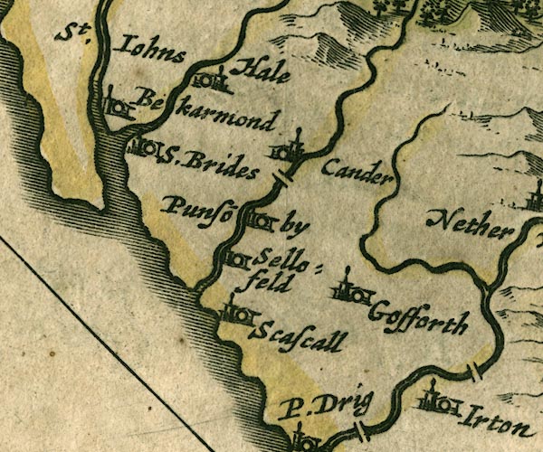 JAN3NY00.jpg
 |
Bleng, River -- river -- NY1108
-- Single wiggly line.
Calder Bridge -- bridge -- NY042059 ? -- Double line crossing the stream. Calder Bridge -- building/s -- NY041060 ? -- 'Cander' -- Buildings and tower. Calder, River -- river etc -- NY0712 (etc) ? -- Double wiggly line, tapering to single. Ehen, River -- river -- NY0515 (etc) ? -- Double wiggly line, tapering to single. Gosforth -- building/s -- NY070035 -- 'Gosforth' -- Buildings and tower. Haile -- building/s -- NY0308 -- 'Hale' -- Buildings and tower. Irton Hall -- building/s -- NY10540056 -- 'Irton' -- Buildings and tower. Kirk Beck -- river -- NY0106 (?) -- Double wiggly line, tapering to single. Ponsonby -- building/s -- NY039059 (? etc) -- 'Punso~by' -- Buildings and tower. Seascale Hall -- building/s -- NY0302 -- 'Scascall' -- Buildings and tower. Sellafield (?) -- locality -- NY0203 -- 'Sellofeld' -- Buildings and tower. St Bridget's Church -- church -- NY01480608 ? -- 'S.Brides' -- Buildings and tower. St John's Church -- church -- NY01870671 -- 'St. Iohns Bekarmond' -- Buildings and tower. | |
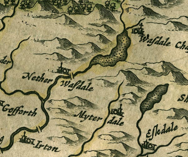 JAN3NY10.jpg
 |
Burnmoor Tarn -- lake -- NY183043 ?
-- Outline with shore shaded, dotted area.
Forest Bridge -- bridge -- NY12840375 ? ? -- Double line crossing the stream. Irt, River -- river etc -- NY1002 (etc) ? -- Double wiggly line tapering to single. Lingmell Beck -- river -- NY1908 ? -- Single wiggly line. Miterdale -- valley -- NY1501 -- 'Myterdale' -- Buildings and tower. Mosedale Beck -- river -- NY1808 -- Single wiggly line. Nether Wasdale -- building/s -- locality -- NY1204 (etc) -- 'Nether Wasdale' -- Buildings and tower. Santon Bridge -- bridge -- NY11020161 -- Double line crossing the stream. St Olaf's Church -- church -- NY18850869 -- 'Wasdale Chap' -- Building and tower with cross. Wast Water -- lake -- NY161059 -- Outline with shore shaded, dotted area. Whillan Beck -- river -- NY1803 (etc) -- Single wiggly line. | |
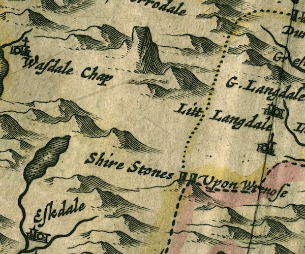 JAN3NY20.jpg
 |
Three Shire Stones -- boundary stone -- stone --
NY27720274 ?
-- 'Shire Stones Upon Wrenose' -- Two, only, square pillars
are drawn, on the county boundaries.
Wrynose Pass -- pass -- NY27700270 -- 'Wrenose' -- Implied by the label for the shire stones. | |
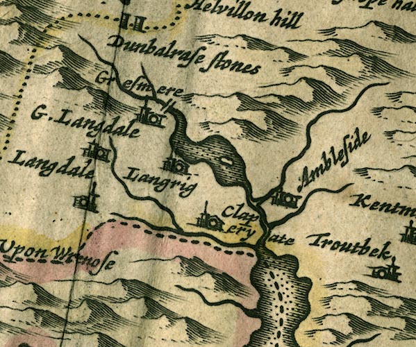 JAN3NY30.jpg
 |
Ambleside -- building/s etc -- NY376045 ?
-- 'Ambleside' -- Buildings and tower.
Blelham Beck -- river -- NY370018 -- Single wiggly line. Brathay, River -- river -- NY3503 -- Single wiggly line; county boundary. Clappersgate -- building/s -- NY366033 -- 'Claperyate' -- Buildings and tower. Easedale Beck -- river -- NY336081 -- Single wiggly line. Grasmere -- building/s -- NY336075 ? -- 'Gresmere' -- Buildings and tower. Great Langdale Beck -- river -- NY3105 -- Single wiggly line. Great Langdale -- building/s -- NY3006 (?) -- 'G. Langdale' -- Buildings and tower. Heron Island -- island -- NY356062 ? ? -- Island; assuming the lake is Rydal Water. probably Little Langdale -- building/s -- locality -- NY315034 -- 'Litt. Langdale' -- Buildings and tower. Loughrigg -- locality -- NY3405 (?) ? -- 'Langrig' -- Buildings and tower. Rothay, River -- river -- NY3308 (etct) -- Double wiggly line. Rydal Beck -- river -- NY365084 (etc) -- Single wiggly line. Rydal Water -- lake -- NY355061 -- Outline with shore shaded, dotted area; it includes Grasmere lake? probably Stock Ghyll -- river -- NY3905 -- Single wiggly line. Windermere lake -- lake -- SD392950 ? -- 'Wynander mere flud' -- Outline with shore shaded, dotted area; the county boundary drawn down the middle. | |
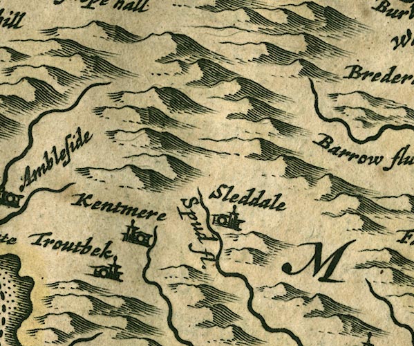 JAN3NY40.jpg
 |
Kentmere -- valley -- NY457040 (etc)
-- 'Kentmere' -- Buildings and tower.
Longsleddale -- valley -- NY4904 (etc) -- 'Sleddale' -- Buildings and tower. Sprint, River -- river etc -- NY4806 (etc) -- 'Spud fl.' -- Single wiggly line. Troutbeck -- building/s -- NY4103 -- 'Troutbek' -- Buildings and tower. | |
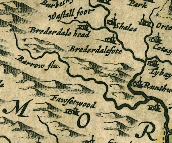 JAN3NY50.jpg
 |
Borrow Beck -- river -- NY5503
-- 'Barrow flu.' -- Single wiggly line.
Bretherdale Beck -- river -- NY5804 (etc) -- Single wiggly line. Bretherdale Foot -- building/s -- NY596043 -- 'Brederdalefote' -- Buildings and tower. Bretherdale Head -- building/s -- NY5705 -- 'Brederdale head' -- Buildings and tower. Forest Hall -- building/s -- NY54810126 ? -- 'Fawsetwood' -- Buildings and tower. Low Scales -- building/s -- NY600055 ? -- 'Shales' -- Buildings and tower. Roundthwaite -- building/s -- NY608023 -- 'Runthwate' -- Buildings and tower. | |
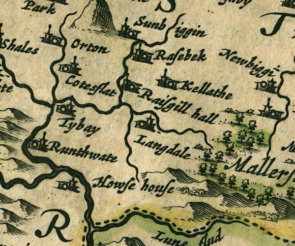 JAN3NY60.jpg
 |
Chapel Beck -- river -- NY6206 (etc)
-- Single wiggly line.
Coatflatt Hall -- building/s -- NY621059 ? -- 'Cotesflat' -- Buildings and tower. Hawse House (?) -- building/s -- house -- NY608006 -- 'Howse house' -- Buildings and tower. Kelleth -- building/s -- NY661052 -- 'Kellathe' -- Buildings and tower. Langdale Beck -- river -- NY6402 (etc) -- Single wiggly line. Longdale -- building/s -- NY644041 -- 'Langdale' -- Buildings and tower. Lune, River -- river etc -- NY6205 (etc) -- 'Lune fl.' -- Double wiggly line tapering to single. Orton -- building/s -- NY621083 -- 'Orton' -- Buildings and tower. Rais Beck -- river -- NY6407 (etc) -- Single wiggly line. Raisbeck -- building/s -- NY645075 -- 'Rasebeck' -- Buildings and tower. Raisgill Hall -- building/s -- NY635058 -- 'Raisgill hall' -- Buildings and tower. Sunbiggin -- building/s -- NY658086 -- 'Sunbiggin' -- Buildings and tower. Tebay -- building/s -- NY616045 -- 'Tybay' -- Buildings and tower. | |
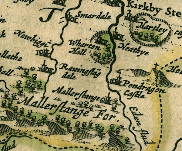 JAN3NY70.jpg
 |
Eden, River -- river etc -- NY3658 (etc)
-- 'Eden flude' -- 'Eden flu.' -- 'Eden flud' -- Double
line with stream lines, tapering to single line; county
boundary for a short stretch.
Hartley Castle -- castle -- park (?) -- NY782082 -- 'Hartley cast.' -- Ring of fence palings with trees; buildings and tower with flag. Mallerstang Forest -- forest -- NY70 (?) & SD79 (?) -- 'Mallerstange For.' -- Group of tree symbols. Mallerstang -- locality -- NY7801 (etc) -- 'Mallerstange' -- Buildings and tower; could be Outhgill. probably Nateby -- building/s -- NY7706 -- 'Neathye' -- Buildings and tower. Newbiggin-on-Lune -- building/s -- NY705051 -- 'Newbiggi~' -- Buildings and tower. Outhgill -- building/s -- NY783016 -- 'Mallerstange' -- Buildings and tower. probably Pendragon Castle -- castle -- NY78180263 -- 'Pendragon Castle' -- Buildings and tower with flag. Ravenstonedale -- building/s -- NY7204 -- 'Ravingsta~gdale' -- Buildings and tower. Smardale -- building/s -- NY739080 (etc) -- 'Smardale' -- Buildings and tower. Wharton Hall -- building/s -- park -- NY770062 -- 'Wharton Hall' -- Buildings and tower in a ring of fence palings with trees. | |
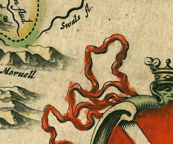
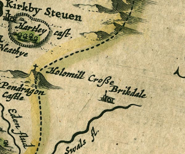 JAN3NY80.jpg
 |
Birkdale -- building/s -- NY8501
-- 'Brikdale' -- Buildings and tower.
Hollow Mill Cross -- boundary stone -- NY81180405 -- 'Holomill Crosse' -- Cross on hillock, on county boundary. Swale, River -- river -- NY80 (etc) -- 'Swals fl.' -- Buildings and tower. | |
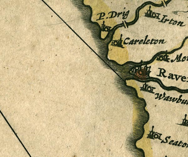 JAN3SD09.jpg
 |
Carleton Hall -- building/s -- SD082987
-- 'Careleton' -- Buildings and tower.
Drigg -- building/s -- SD0698 -- 'P. Drig' -- Buildings and tower; compare Morden 1695. probably Esk, River -- river etc -- NY2101 (etc) ? -- 'Denok fl' -- Double wiggly line; the label belongs to the lake? probably Holme Bridge -- packhorse bridge -- bridge -- SD07709872 ? ? -- Double line crossing the stream. probably Irt, River -- river etc -- NY1002 (etc) ? -- Double wiggly line tapering to single. Mite, River -- river etc -- NY1602 -- Double wiggly line tapering to single. Ravenglass -- building/s etc -- SD085964 -- 'Ravenglas' -- Buildings and towers, suggestion of a wall, notice ?fence palings; upright lowercase text; market town. Waberthwaite -- building/s -- SD104935 -- 'Wawburthwat' -- Buildings and tower. | |
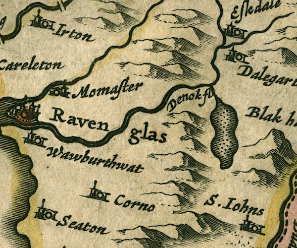 JAN3SD19.jpg
 |
Corney -- building/s -- SD115914 ?
-- 'Corno' -- Buildings and tower.
Dalegarth Hall -- building/s -- NY169001 ? -- 'Dalegarth' -- Buildings and tower. Devoke Water -- lake -- SD158969 -- 'Denok fl' -- Outline with shore shaded, dotted area; the River Esk, not the lake, is labelled. probably Esk, River -- river etc -- NY2101 (etc) ? -- 'Denok fl' -- Double wiggly line; the label belongs to the lake? probably Eskdale Green -- building/s -- NY141001 -- 'Eskdale' -- Buildings and tower. Muncaster Castle -- castle -- SD103964 ? -- 'Momaster' -- Buildings and tower. Seaton Hall -- building/s -- priory (ex) -- religious house (ex) -- SD107899 -- 'Seaton' -- Buildings and tower. | |
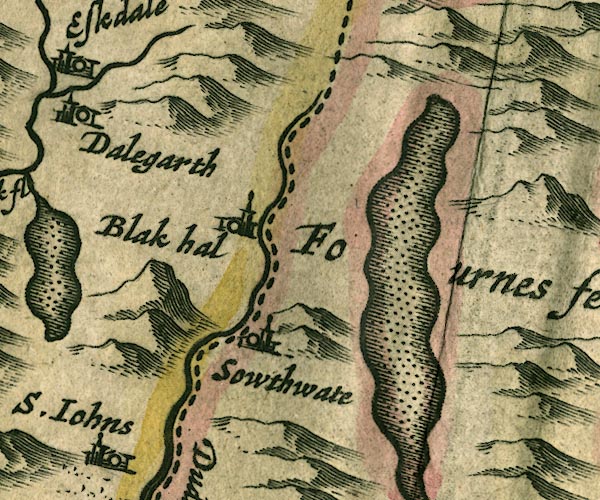 JAN3SD29.jpg
 |
Black Hall -- building/s -- NY23920120 ? ?
-- 'Blak hal' -- Buildings and tower.
Coniston Water -- lake -- SD302943 -- Outline with shore shaded, dotted area. Duddon, River -- river etc -- NY2602 (etc) -- 'Dudden flud' -- Single wiggly line; county boundary. Furness Fells -- hill -- fell -- SD3389 (etc) -- 'Fournes fells' -- Labelling the area, no symbol. Seathwaite -- building/s -- SD227960 ? -- 'Sowthwate' -- Buildings and tower. | |
 JAN3SD39.jpg
 |
Calgarth Hall -- building/s -- SD398996 ?
-- 'Cowgarth' -- Buildings and tower.
Claife -- area -- SD3798 (etc) -- 'Classe' -- Buildings and tower. Cunsey -- locality -- SD3893 -- Single wiggly line. Esthwaite Water -- lake -- SD3696 (etc) -- Outline with shore shaded, dotted area. Furness Fells -- hill -- fell -- SD3389 (etc) -- 'Fournes fells' -- Labelling the area, no symbol. Holy Trinity Church -- church -- SD417930 -- 'Wynster chap.' -- Building and tower with cross. Trout Beck -- river -- NY4104 (etc) ? -- Single wiggly line. Windermere lake -- lake -- SD392950 ? -- 'Wynander mere flud' -- Outline with shore shaded, dotted area; the county boundary drawn down the middle. Windermere -- building/s -- SD412985 -- 'Wÿnandermere' -- Buildings and tower. | |
 JAN3SD49.jpg
 |
Bowston Bridge -- bridge -- SD49869660 ?
-- Double line crossing the stream.
bridge, Burneside -- bridge -- SD50529580 ? -- Double line crossing the stream. Burneside -- building/s -- SD505955 -- 'Barnside' -- Buildings and tower. Crook -- building/s -- SD464951 -- 'Croke' -- Buildings and tower. Cunswick Hall -- building/s -- park -- SD486934 -- 'Camswik park' -- Ring of fence palings with trees. probably Gowan, River -- river -- SD4598 -- Single wiggly line. Ings -- building/s -- SD445986 -- 'Chapollon The Inges' -- Buildings and tower. Kendal -- building/s etc -- SD514926 -- 'Kendall' -- Buildings and towers, suggestion of a wall, notice ?fence palings; upright lowercase text; market town. Clonhead Park -- park -- SD4997 -- 'Colnhead park' -- Ring of fence palings. Sprint Bridge -- bridge -- SD51329602 -- Double line crossing the stream. Sprint, River -- river etc -- NY4806 (etc) -- 'Spud fl.' -- Single wiggly line. Staveley -- building/s etc -- SD470984 -- 'Stanlay' -- Buildings and tower. | |
 JAN3SD59.jpg
 |
Docker Bridge -- bridge -- SD56559630
-- Double line crossing the stream; not identified.
probably
Grayrigg Hall -- building/s -- SD57949750 -- 'Grariggehall' -- Buildings and tower. Kent, River -- river etc -- NY4506 (etc) -- Double wiggly line tapering to single. Lambrigg Beck (?) -- river -- boundary -- parish boundary -- SD5696 (etc) ? ? -- Single wiggly line. possibly Lambrigg Park -- park -- SD595942 (etc) ? ? -- Ring of fence palings with trees; or Old Park, Killington. possibly Lambrigg -- locality -- SD5895 -- 'Lanridge' -- Buildings and tower. Laverock Bridge -- packhorse bridge -- bridge (ex) -- SD53569517 ? -- Buildings and tower. Mint, River -- river -- SD5596 -- Single wiggly line. Old Park -- park -- SD6089 ? ? -- Ring of fence palings with trees; or Lambrigg Park. possibly Patton Bridge -- building/s -- SD5597 -- Double line crossing the stream. Selside Hall -- building/s -- SD5399 ? -- 'Selstedhall' -- Buildings and tower. Skelsmergh Hall Farm -- building/s -- SD531959 -- 'Sleelmere' -- Buildings and tower. -- Ring of fence palings. Whinfell -- locality -- NY5700 -- 'Whinfeld' -- Buildings and tower. | |
 JAN3SD69.jpg
 |
Carlingill Beck -- river -- boundary -- county boundary
(once) -- parish boundary -- SD6399 (etc)
-- 'Lune flud' -- Single wiggly line; county boundary.
Clough River -- river -- SD7389 (etc etc) -- Double wiggly line, tapering to single. Crook of Lune Bridge -- bridge -- SD62029631 -- Double line crossing the stream; at county boundary. Dillicar -- building/s (mostly gone) -- locality -- SD6197 -- Approximate 10Km square, plus overlaps. Firbank -- building/s -- SD626940 (etc) -- 'Firbank' -- Buildings and tower. Howgill -- SD6396 (etc) -- 'Howgill' -- Buildings and tower. Killington -- building/s -- SD6188 ? -- 'Killinton' -- Buildings and tower. Lune, River -- river etc -- NY6205 (etc) -- 'Lune fl.' -- Double wiggly line tapering to single. Sedbergh -- building/s -- SD662921 -- 'Sedber' -- Buildings and tower. | |
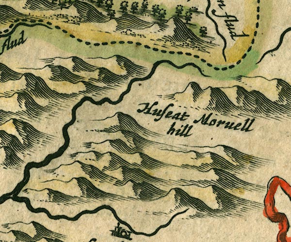 JAN3SD79.jpg
 |
Hugh Seat -- hill -- SD80919910
-- 'Huseat Morvell Hill' -- Hillock, near the county
boundary.
Rawthey, River -- river -- SD6894 (etc etc) ? -- Double wiggly line tapering to single. | |
 JAN3SD89.jpg
 | ||
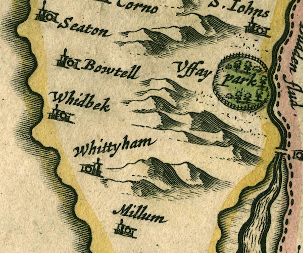 JAN3SD18.jpg
 |
Bootle -- building/s etc -- SD108883
-- 'Bowtell' -- Buildings and tower.
Millom -- building/s -- SD171801 -- 'Millum' -- Buildings and tower. Ulpha Park -- park -- SD187911 (etc) -- 'Uffay Park' -- Ring of fence palings with trees. Whicham -- building/s -- SD132825 -- 'Whittyham' -- Buildings and tower. Whitbeck -- building/s -- SD118845 -- 'Whidbek' -- Buildings and tower. | |
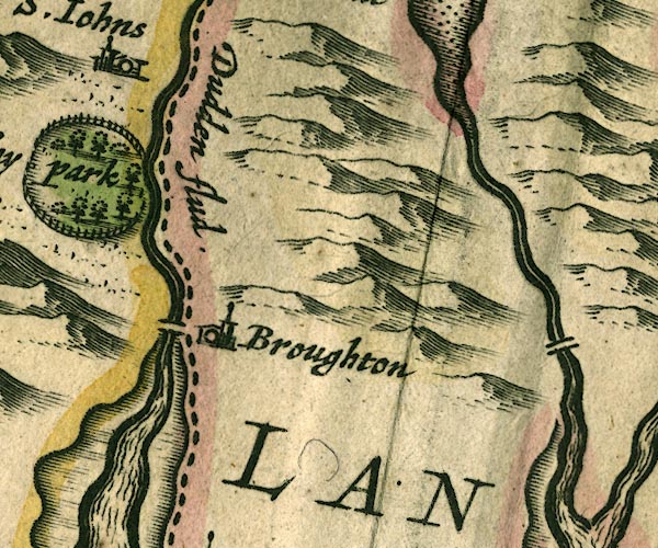 JAN3SD28.jpg
 |
Broughton in Furness -- building/s etc -- SD211876
-- 'Broughton' -- Buildings and tower.
Crake, River -- river etc -- SD2987 (etc) -- Double wiggly line. Duddon Bridge -- bridge -- SD19928818 -- Double line crossing the stream; at county boundary. Duddon Estuary -- estuary -- river estuary etc -- SD1475 (etc) Duddon, River -- river etc -- NY2602 (etc) -- 'Dudden flud' -- Single wiggly line; county boundary. St John's Church -- church -- SD19799325 -- 'S. Johns' -- Buildings and tower. | |
 JAN3SD38.jpg
 |
Leven, River -- river etc -- SD3483 (etc) ?
-- Double wiggly line with stream lines.
Newby Bridge -- building/s -- SD370865 -- 'Newe Bridge' -- Buildings and tower. Spark Bridge -- building/s -- SD306848 -- Buildings and tower. Windermere lake -- lake -- SD392950 ? -- 'Wynander mere flud' -- Outline with shore shaded, dotted area; the county boundary drawn down the middle. | |
 JAN3SD48.jpg
 |
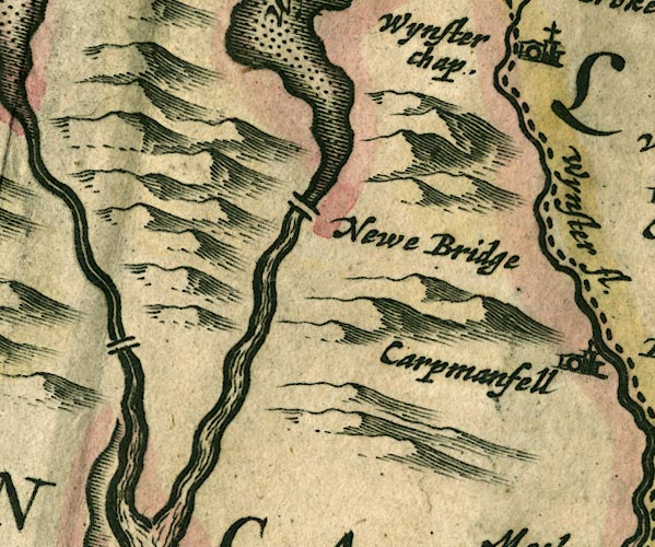
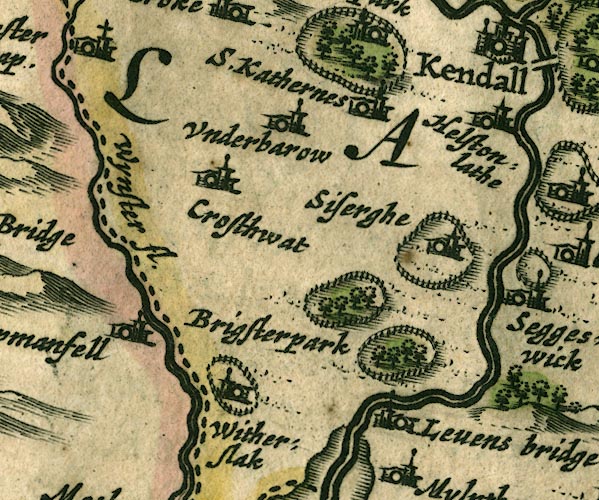
Brigsteer Park -- park -- SD4888
-- 'Brigsterpark' -- Ring of fence palings with trees.
Cartmel Fell -- building/s -- SD415880 (etc) ? -- 'Carpmanfell' -- Buildings and tower. Crosthwaite -- building/s -- SD437915 -- 'Crosthwat' -- Buildings and tower. Helsington Laithes -- building/s -- SD506907 ? -- 'Helstonlathe' -- Buildings and tower. Kent, River -- river etc -- NY4506 (etc) -- Double wiggly line tapering to single. Levens Bridge -- bridge -- SD49618522 -- '[Levens bridge]' -- No bridge symbol; the label is used for Levens Hall. Levens Hall -- building/s -- house -- garden -- SD494850 -- 'Levens bridge' -- Buildings and tower. Levens Park -- park -- SD5085 -- Ring of fence palings with trees. Sizergh Castle -- building/s -- house -- park -- SD493874 -- 'Siserghe' -- Buildings and tower in a ring of fence palings. St Catherine's Church -- church -- SD45099506 -- 'S. Kathernes' -- Buildings and tower. Underbarrow -- building/s -- SD465922 -- 'Underbarow' -- Buildings and tower. Winster, River -- river -- SD4285 (etc) -- 'Wynster fl.' -- Double wiggly line tapering to single; county boundary. Witherslack Hall -- building/s -- park -- school -- SD436861 -- 'Witherslak' -- Buildings and tower. -- Ring of fence palings. probably | |
 JAN3SD58.jpg
 |
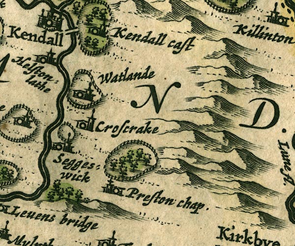
Crosscrake -- building/s -- SD524870
-- 'Croscrake' -- Buildings and tower.
Kendal Castle -- castle -- SD521924 -- 'Kendall Castle' -- Buildings and tower with flag, in a ring of fence palings with trees. Kent, River -- river etc -- NY4506 (etc) -- Double wiggly line tapering to single. Natland Park -- building/s -- SD521897 -- 'Watlande' -- Ring of fence palings. Natland -- building/s -- SD5289 -- 'Watlande' -- Buildings and tower. park, Sedgwick -- park -- SD5187 -- 'Seggeswick' -- Ring of fence palings. Preston Patrick Hall -- building/s -- park -- SD544837 ? -- Ring of fence palings with trees. Sedgwick -- building/s -- SD5187 -- 'Seggeswick' -- Buildings and tower. St Patrick's Church -- church -- SD53698351 -- 'Preston chap.' -- Building and tower with cross. Stramongate Bridge -- bridge -- SD51859297 -- Double line crossing the stream. | |
 JAN3SD68.jpg
 |
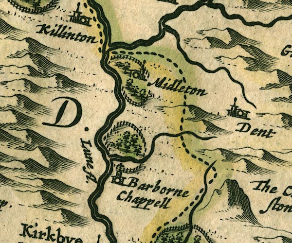
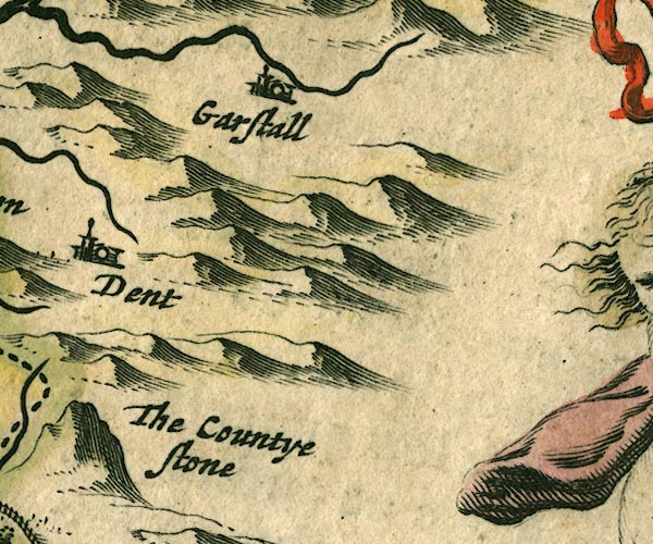
Barbon Beck -- river -- SD6482
-- Single wiggly line.
Barbon Park -- park -- SD6483 -- Ring of fence palings with trees. County Stone -- boundary stone -- stone -- county boundary mark -- SD70148274 -- 'The Countye Stone' -- Lumpy hillock, no stone drawn, by county boundary. Dent -- building/s -- SD705871 -- 'Dent' -- Buildings and tower. Garsdale -- building/s -- SD7489 ? -- 'Garstall' -- Buildings and tower. Lune, River -- river etc -- NY6205 (etc) -- 'Lune fl.' -- Double wiggly line tapering to single. Middleton Hall -- building/s -- park -- SD626875 -- 'Midleton' -- Buildings and tower in a ring of fence palings with trees. Rawthey, River -- river -- SD6894 (etc etc) ? -- Double wiggly line tapering to single. St Bartholomew's Church -- church -- SD63038246 -- 'Barborne Chappell' -- building and tower with cross | |
 JAN3SD78.jpg
 | ||
 JAN3SD17.jpg
 |
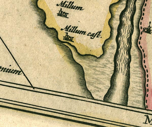
Duddon Estuary -- estuary -- river estuary etc -- SD1475
(etc)
Millom Castle -- castle -- SD171813 -- 'Millum cast.' -- Buildings and tower with flag. | |
 JAN3SD27.jpg
 |
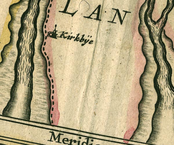
Kirkby-in-Furness -- building/s -- SD226825
-- 'Kirkbÿe' -- Buildings and tower.
| |
 JAN3SD37.jpg
 |
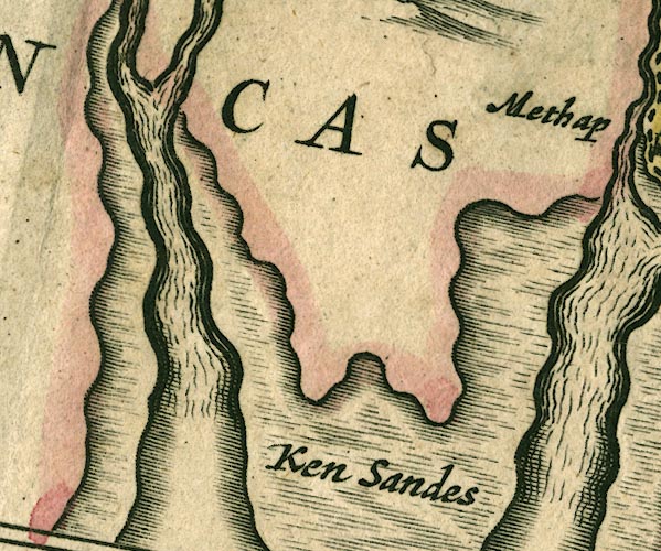
Cartmel Sands -- sands -- SD3376 (etc)
-- 'Ken Sandes' -- Foreshore drawn with moire effect.
Leven Estuary -- estuary -- river estuary -- sea area -- SD3375 (etc) | |
 JAN3SD47.jpg
 |
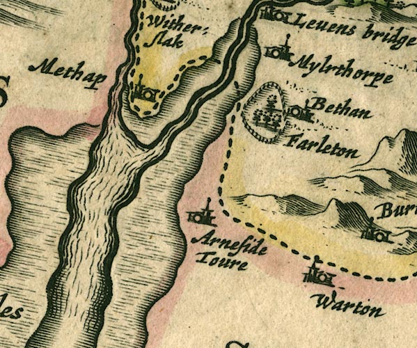
Arnside Tower -- tower -- castle -- pele -- SD458768
-- 'Arneside Toure' -- Buildings and tower.
Beetham Park -- park -- SD4978 -- 'Bethan' -- Ring of fence palings with trees. Beetham -- building/s -- SD4979 -- 'Bethan' -- Buildings and tower. Kent Estuary -- estuary -- river estuary -- sea area -- SD4377 (etc) Milnthorpe -- building/s -- SD496815 -- 'Mylrthorpe' -- Buildings and tower. Warton -- building/s -- SD5072 -- 'Warton' -- Buildings and tower. Winster, River -- river -- SD4285 (etc) -- 'Wynster fl.' -- Double wiggly line tapering to single; county boundary. | |
 JAN3SD57.jpg
 |
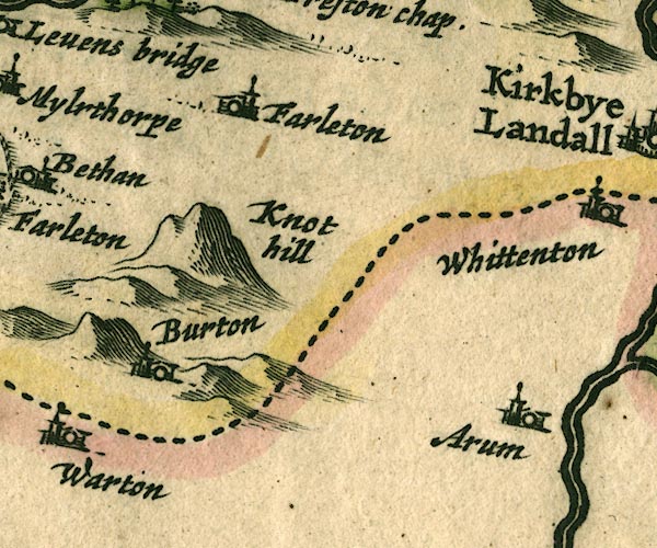
Arkholme -- building/s -- SD583722
-- 'Arum' -- Buildings and tower.
Burton-in-Kendal -- building/s -- SD531765 -- 'Burton' -- Buildings and tower. Farleton Knott -- rocks -- SD5480 ? -- 'Farleton Knot hill' -- Lumpy hillock. Farleton -- building/s -- SD535810 -- 'Farleton' -- Buildings and tower. | |
 JAN3SD67.jpg
 |
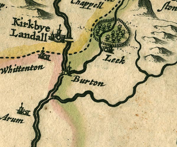
Burton in Lonsdale -- building/s -- SD652722
-- 'Burton' -- Buildings and tower.
Devil's Bridge -- bridge -- SD61557823 -- Double line crossing the stream. Fairthwaite Park House -- building/s -- park -- SD638770 -- Ring of fence palings with trees. perhaps Greta, River -- river -- SD599728 -- Double wiggly line tapering to single. Kirkby Lonsdale -- building/s -- SD6178 -- 'Kirkbye Landall' -- Buildings and towers, suggestion of a wall, notice ?fence palings; upright lowercase text; market town. Leck -- building/s -- SD643767 ? -- 'Leek' -- Buildings and tower. Lune, River -- river etc -- NY6205 (etc) -- 'Lune fl.' -- Double wiggly line tapering to single. Wenning, River -- river -- SD571683 -- Double wiggly line. Whittington -- building/s -- SD600763 -- 'Whittenton' -- Buildings and tower. | |
 Lakes Guides menu.