 Garnett 1850s-60s H
 |
 |
|
|
Places Identified
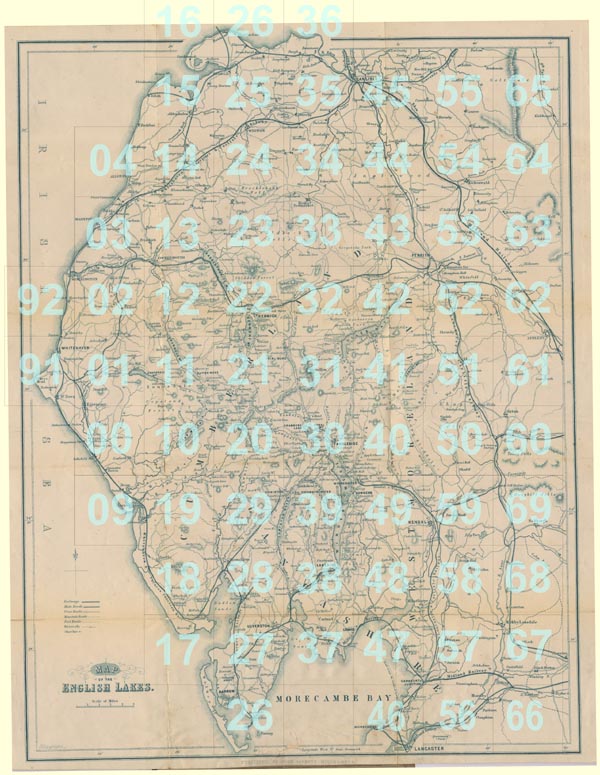
Map of the English Lakes, in Cumberland, Westmorland and Lancashire, scale about 3.5 miles to 1 inch, published by John Garnett, Windermere, Westmorland, 1850s-60s. NB: each image includes an overlap, places in the overlap are not listed. The images are roughly equivalent to ngr 10Km squares and are listed from top left to bottom right. | ||
 GAR2Sqs.jpg
 | ||
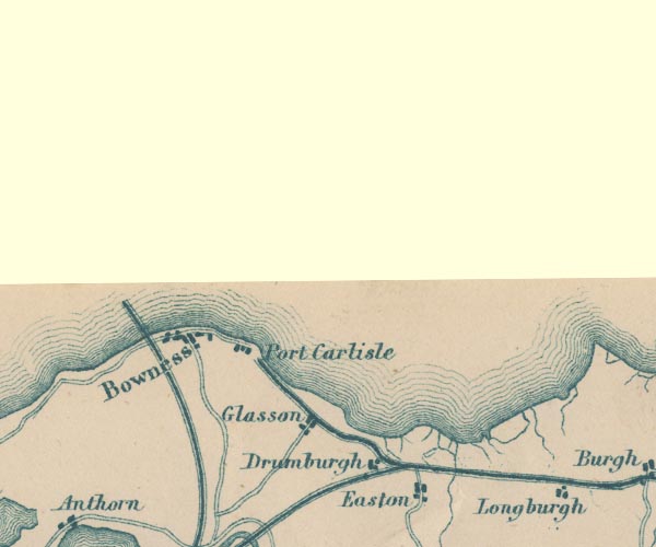 GAR2NY26.jpg
 |
Bowness-on-Solway -- building/s -- NY224628
-- blocks, settlement
Drumburgh -- building/s -- NY2659 -- 'Drumburgh' -- blocks, settlement Easton -- building/s -- NY2759 -- 'Easton' -- blocks, settlement Glasson -- building/s -- NY2560 -- 'Glasson' -- blocks, settlement Port Carlisle Dock and Railway -- railway -- triple line, light bold light, railway Port Carlisle -- building/s -- NY241622 -- 'Port Carlisle' -- blocks, settlement Solway Junction Railway -- railway etc -- triple line, light bold light, railway | |
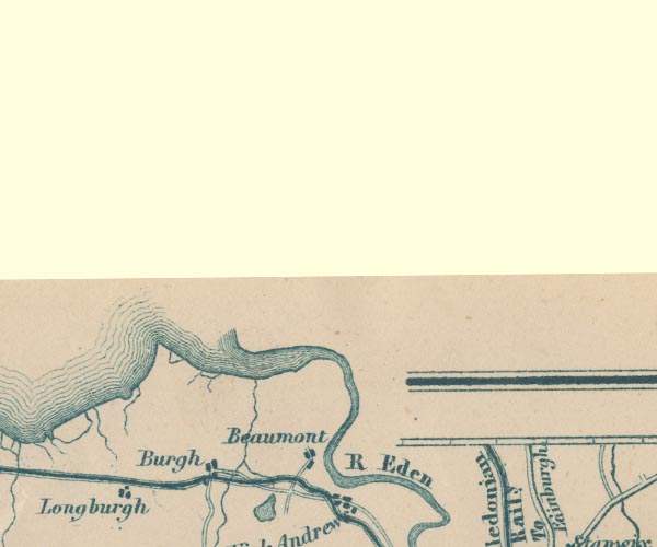 GAR2NY36.jpg
 |
Beaumont -- building/s -- NY3459
-- 'Beaumont' -- blocks, settlement
Burgh by Sands -- building/s -- NY323591 -- 'Burgh' -- blocks, settlement Eden, River -- river -- NY3658 (etc) -- 'R Eden' -- 'Riv. Eden' -- 'Eden R.' -- river, double line -- part marked as county boundary Longburgh -- building/s -- NY3058 -- blocks, settlement Port Carlisle Dock and Railway -- railway -- triple line, light bold light, railway | |
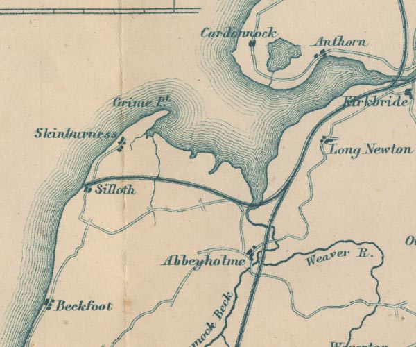 GAR2NY15.jpg
 |
Abbey Town -- building/s etc -- NY1750
-- 'Abbeyholme' -- blocks, settlement
Anthorn -- building/s -- NY1958 -- 'Anthorn' -- blocks, settlement Beckfoot -- building/s -- NY0944 -- 'Beckfoot' -- blocks, settlement Cardurnock -- building/s -- NY1758 -- 'Cardunnock' -- blocks, settlement Carlisle and Silloth Bay Railway -- railway -- triple line, light bold light, railway Grune Point -- headland -- NY1456 -- 'Grune pt.' -- headland lake, Cardurnock -- lake (drained?) -- NY179582 (etc) -- outline with shore form lines, lake or tarn Moricambe -- bay -- foreshore -- NY1656 (etc) -- bay Newton Arlosh -- building/s -- NY1955 -- 'Long Newton' -- blocks, settlement Silloth -- building/s etc -- NY1153 -- 'Silloth' -- blocks, settlement Skinburness -- building/s etc -- NY1255 -- 'Skinburness' -- blocks, settlement Solway Junction Railway -- railway etc -- triple line, light bold light, railway Waver, River -- river etc -- NY2344 (etc) -- 'Weaver R.' -- 'R. Weaver' -- wiggly line, river | |
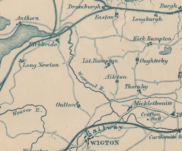 GAR2NY25.jpg
 |
Aikton -- building/s -- NY2753
-- 'Aikton' -- blocks, settlement
Crofton Hall -- building/s -- NY3049 -- 'Crofton Hall' -- block, building Kirkbampton -- building/s -- NY3056 -- 'Kirk Bampton' -- blocks, settlement Kirkbride -- building/s -- NY229568 -- 'Kirkbride' -- blocks, settlement Little Bampton -- building/s -- NY2755 -- 'Lit. Bampton' -- blocks, settlement Maryport and Carlisle Railway -- railway etc -- 'Whitehaven Maryport & Carlisle Railway' -- triple line, light bold light, railway Micklethwaite -- building/s -- NY2850 -- 'Micklethwaite' -- blocks, settlement Oughterby -- building/s -- NY2955 -- 'Oughterby' -- blocks, settlement Oulton -- building/s -- NY248507 -- 'Oulton' -- blocks, settlement Port Carlisle Dock and Railway -- railway -- triple line, light bold light, railway Solway Junction Railway -- railway etc -- triple line, light bold light, railway Thornby -- building/s -- NY2952 -- 'Thornby' -- blocks, settlement Wampool, River -- river etc -- NY2453 (etc) ? -- 'Wampool R.' -- wiggly line, river, broader at estuary | |
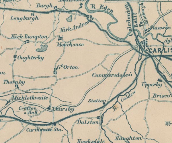 GAR2NY35.jpg
 |
Caldew, River -- river -- NY3851 (etc) ?
-- 'R. Caldew' -- 'R. Caldew' -- 'Caldew R.' -- wiggly
line, river
Caledonian Railway -- railway -- 'Caledonian Raily.' -- triple line, light bold light, railway Cummersdale -- building/s -- NY3853 -- 'Cummersdale' -- blocks, settlement Curthwaite Station -- railway station -- station -- NY326492 -- 'Curthwaite Sta.' -- dot by railway Dalston Station -- railway station -- station -- NY36955057 -- 'Station' -- dot by railway Dalston -- building/s -- NY369501 -- 'Dalston' -- blocks, settlement Eden, River -- river -- NY3658 (etc) -- 'R Eden' -- 'Riv. Eden' -- 'Eden R.' -- river, double line -- part marked as county boundary Great Orton -- building/s -- NY3254 -- 'Gt. Orton' -- blocks, settlement Kirkandrews -- locality -- NY3569 (etc) -- 'Kirkandrews' -- blocks, settlement Maryport and Carlisle Railway -- railway etc -- 'Whitehaven Maryport & Carlisle Railway' -- triple line, light bold light, railway Moorhouse -- building/s -- NY331568 -- 'Moorhouse' -- blocks, settlement probably Port Carlisle Dock and Railway -- railway -- triple line, light bold light, railway Carlisle to Jedburgh -- road -- route etc -- NY35 -- 'To Edinburgh' -- double line, bold light, major road Cockermouth to Carlisle -- road -- route -- NY13 -- double line, bold light, major road Thursby -- building/s -- NY3250 -- 'Thursby' -- blocks, settlement Thurstonfield Lough -- lake -- NY3156 -- outline with shore form lines, lake or tarn | |
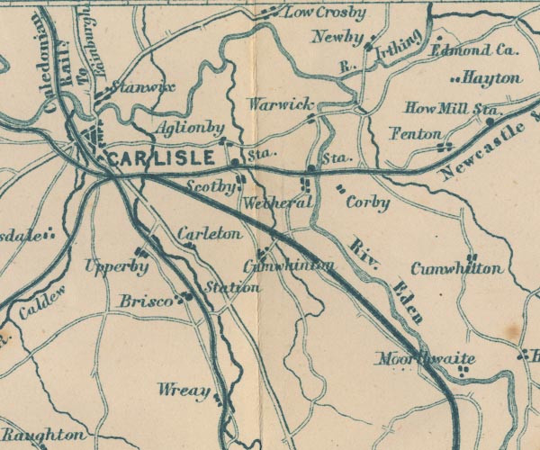 GAR2NY45.jpg
 |
Aglionby -- building/s -- NY4456
-- 'Aglionby' -- blocks, settlement
Brisco Station, St Cuthbert Without -- railway station -- NY410519 (about) -- 'Station' -- dot by railway Brisco -- building/s -- NY410519 -- 'Brisco' -- blocks, settlement Cairn Beck -- river -- NY5054 (etc) -- wiggly line, river, from Newbiggin Carleton -- building/s -- NY428528 -- 'Carleton' -- blocks, settlement Carlisle -- building/s -- roman site etc -- NY403558 -- 'CARLISLE' -- blocks, minimal street plan, city Cumwhinton -- building/s -- NY451528 -- 'Cumwhinton' -- blocks, settlement Eden, River -- river -- NY3658 (etc) -- 'R Eden' -- 'Riv. Eden' -- 'Eden R.' -- river, double line -- part marked as county boundary Edmond Castle -- castle -- NY496586 -- 'Edmond Ca.' -- block, building Fenton -- building/s -- NY502560 -- 'Fenton' -- blocks, settlement Great Corby -- building/s -- NY472543 -- 'Corby' -- blocks, settlement Irthing, River -- river -- boundary -- county boundary -- NY4758 (etc etc) -- 'R. Irthing' -- river, double line Lancaster and Carlisle Railway -- railway -- 'Lancaster & Carlisle Railway' -- 'Lancaster & Carlisle Railway' -- triple line, light bold light, railway Low Crosby -- building/s -- NY446595 -- 'Low Crosby' -- blocks, settlement Newby East -- building/s -- NY475581 -- 'Newby' -- blocks, settlement Newcastle and Carlisle Railway -- railway etc -- 'Newcastle & Carlisle Raily.' -- triple line, light bold light, railway Petteril, River -- river -- NY4935 (etc etc) -- 'R Petterill' -- 'R. Petterill' -- wiggly line, river Brampton to Carlisle -- road -- route -- NY56 -- double line, bold light, major road Penrith to Carlisle -- route -- road -- NY53 ? -- double line, bold light, major road Scotby Station -- railway station (ex) -- station (ex) -- NY43875528 -- 'Sta.' -- dot by railway Scotby -- building/s -- NY441550 -- 'Scotby' -- blocks, settlement Settle and Carlisle Railway -- railway etc -- 'Midland Railway' -- triple line, light bold light, railway Stanwix -- building/s -- locality -- NY3957 -- 'Stanwix' -- blocks, settlement Upperby -- building/s -- NY4053 ? -- 'Upperby' -- blocks, settlement Warwick -- building/s -- NY465566 -- 'Warwick' -- blocks, settlement Wetheral Station -- railway station -- station -- NY466546 -- 'Sta.' -- dot by railway Wetheral -- building/s -- NY4654 -- 'Wetheral' -- blocks, settlement Wreay -- building/s -- NY435489 ? -- 'Wreay' -- blocks, settlement | |
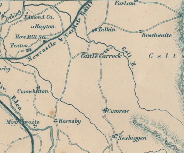 GAR2NY55.jpg
 |
Castle Carrock -- building/s -- NY5455
-- 'Castle Carrock' -- blocks, settlement
Croglin Water -- river -- NY5746 (etc) -- 'Croglin W.' -- wiggly line, river Cumrew -- building/s -- NY5450 -- 'Cumrew' -- blocks, settlement Cumwhitton -- building/s -- NY5052 -- 'Cumwhitton' -- blocks, settlement Farlam -- building/s -- NY5558 -- 'Farlam' -- blocks, settlement Forest Head -- building/s -- NY580577 -- 'Brathwaite' -- blocks, settlement possibly Gelt, River -- river -- NY5456 (etc) ? -- 'Gelt R.' -- wiggly line, river Hayton -- building/s -- NY5057 ? -- 'Hayton' -- blocks, settlement Hornsby -- building/s -- NY515501 -- 'Hornsby' -- blocks, settlement How Mill Station -- railway station (gone) -- station (gone) -- NY51005655 -- 'How Mill Sta.' -- dot by railway Moorthwaite -- building/s -- NY503503 (?) -- 'Moorthwaite' -- blocks, settlement Newbiggin -- building/s -- NY558491 -- 'Newbiggen' -- blocks, settlement Newcastle and Carlisle Railway -- railway etc -- 'Newcastle & Carlisle Raily.' -- triple line, light bold light, railway Talkin -- building/s -- NY549573 -- 'Talkin' -- blocks, settlement | |
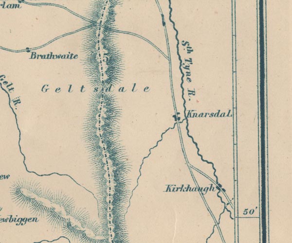 GAR2NY65.jpg
 |
Geltsdale -- area -- NY55
-- 'Geltsdale' -- area
Kirkhaugh -- building/s -- NY6949 -- 'Kirkhaugh' -- blocks, settlement Knarsdale -- building/s -- NY6754 -- 'Knarsdal' -- blocks, settlement Pennines, The -- hill -- NY55 -- hill hachuring, range of hills South Tyne, River -- river etc -- NY7441 (etc) ? -- 'Sth. Tyne R.' -- wiggly line, river | |
 GAR2NY04.jpg
 |
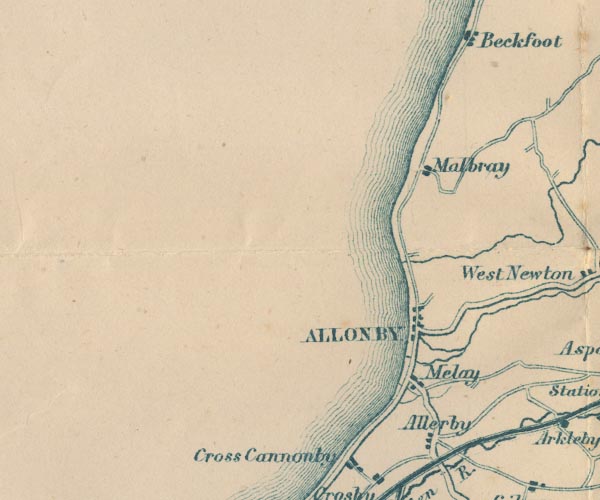
Allerby -- building/s -- NY0839
-- 'Allerby' -- blocks, settlement
Allonby -- building/s -- NY0843 -- 'ALLONBY' -- blocks, settlement Black Dub -- river -- boundary -- parish boundary -- NY0944 (etc) -- wiggly line, river, apparently joined to Holme Dub Mawbray -- building/s -- NY0846 -- 'Malbray' -- blocks, settlement Mealo -- locality -- NY0741 -- 'Melay' -- blocks, settlement | |
 GAR2NY14.jpg
 |
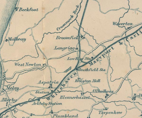
Allhallows -- locality -- NY1842
-- 'Allhallows' -- blocks, settlement
Aspatria Station -- railway station -- station -- NY144413 -- 'Sta' -- dot by railway Aspatria -- building/s etc -- NY1441 -- 'Aspatria' -- blocks, settlement Blennerhasset -- building/s -- NY1741 -- 'Blennerhasset' -- blocks, settlement Brayton Park -- park -- building/s (once) -- NY1642 -- 'Brayton Hall' -- blocks, settlement Bromfield -- building/s -- NY1746 -- 'Broomfield' -- blocks, settlement Crummock Beck -- river -- NY1846 (etc) ? ? -- 'Crummock Beck' -- wiggly line, river; Cruumock Beck is now understood to flow from Brocklebank Fell, the branch labelled to be Holme Dub Holme Dub -- river -- NY1446 -- 'Crummock Beck' -- wiggly line, river; Cruumock Beck is now understood to flow from Brocklebank Fell Langrigg -- building/s -- NY1645 -- 'Langrigg' -- blocks, settlement Low Row Station -- railway station -- station -- NY584630 -- 'Low Row Sta' -- dot by railway Maryport and Carlisle Railway -- railway etc -- 'Whitehaven Maryport & Carlisle Railway' -- triple line, light bold light, railway siding, Arkleby -- railway siding -- NY13124022 -- 'Arkleby Station' -- dot by railway Solway Junction Railway -- railway etc -- triple line, light bold light, railway Westnewton -- building/s -- NY1344 -- 'West Newton' -- blocks, settlement | |
 GAR2NY24.jpg
 |
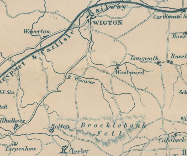
Bolton Low Houses -- building/s -- NY2344
-- 'Bolton' -- blocks, settlement
Brocklebank Fell -- hill -- NY3840 (etc etc) -- 'Brocklebank Fell' -- hill hachuring Maryport and Carlisle Railway -- railway etc -- 'Whitehaven Maryport & Carlisle Railway' -- triple line, light bold light, railway Cockermouth to Carlisle -- road -- route -- NY13 -- double line, bold light, major road Waver, River -- river etc -- NY2344 (etc) -- 'Weaver R.' -- 'R. Weaver' -- wiggly line, river Waverton -- building/s -- NY2247 ? ? -- 'Waverton' -- blocks, settlement Westward -- building/s -- NY2744 -- 'Westward' -- blocks, settlement Wigton -- building/s etc -- NY255484 -- 'WIGTON' -- blocks, settlement | |
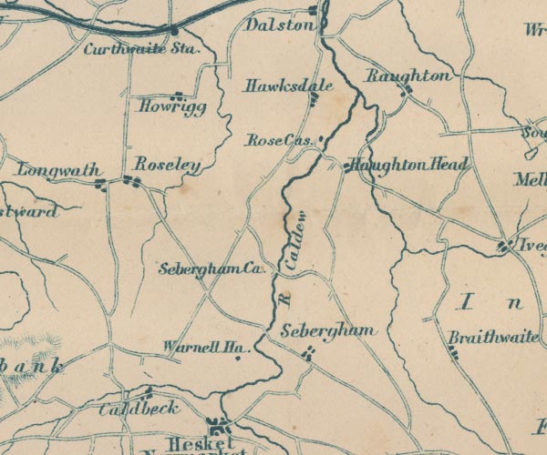 GAR2NY34.jpg
 |
Caldbeck -- building/s -- NY3239
-- 'Caldbeck' -- blocks, settlement
Caldew, River -- river -- NY3851 (etc) ? -- 'R. Caldew' -- 'R. Caldew' -- 'Caldew R.' -- wiggly line, river Hawksdale -- building/s -- NY3648 -- 'Hawksdale' -- blocks, settlement Howrigg -- building/s -- NY3247 -- 'Howrigg' -- blocks, settlement Longwath -- building/s -- NY3145 -- 'Longwath' -- blocks, settlement Raughton Head -- building/s -- NY3845 -- 'Haughton Head (sic)' -- blocks, settlement Raughton -- building/s -- NY3947 -- 'Raughton' -- blocks, settlement Rose Castle -- bishop's palace -- palace -- castle -- NY3746 -- 'Rose Cas.' -- block, building Rosley -- building/s -- NY3245 -- 'Roseley' -- blocks, settlement Sebergham Castle -- castle -- NY3343 -- 'Sebergham Ca.' -- no symbol Sebergham -- building/s -- NY357418 -- 'Sebergham' -- blocks, settlement Warnell Hall -- building/s -- NY3541 ? -- 'Warnell Ha.' -- block, building | |
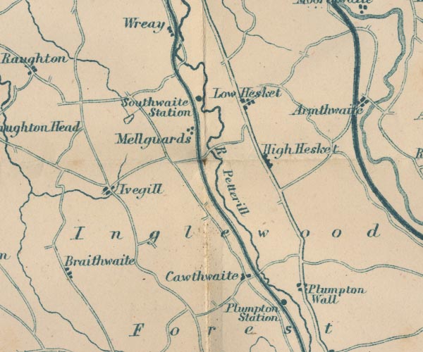 GAR2NY44.jpg
 |
Braithwaite Hall -- building/s -- NY4141
-- 'Braithwaite' -- perhaps
Calthwaite -- building/s -- NY469401 -- 'Cawthwaite' -- blocks, settlement High Hesket -- building/s -- NY476445 ? -- 'High Hesket' -- blocks, settlement Inglewood Forest -- forest -- 'Inglewood Forest' -- area Ivegill -- building/s -- NY419432 -- 'Ivegill' -- blocks, settlement lake, Monkcastle -- pit (disused) -- lake (?) -- NY42504583 -- outline, lake or tarn Lancaster and Carlisle Railway -- railway -- 'Lancaster & Carlisle Railway' -- 'Lancaster & Carlisle Railway' -- triple line, light bold light, railway Low Hesket -- building/s -- NY465463 ? -- 'Low Hesket' -- blocks, settlement Mellguards -- building/s -- NY445460 -- 'Mellguards' -- blocks, settlement Petteril, River -- river -- NY4935 (etc etc) -- 'R Petterill' -- 'R. Petterill' -- wiggly line, river Plumpton Station -- railway station -- station -- NY487370 -- 'Plumpton Station' -- dot by railway Plumpton Wall -- building/s -- NY495378 -- 'Plumpton Wall' -- blocks, settlement Penrith to Carlisle -- route -- road -- NY53 ? -- double line, bold light, major road Southwaite Station -- railway station -- station -- NY449451 -- 'Southwaite Station' -- dot by railway | |
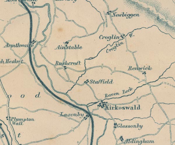 GAR2NY54.jpg
 |
Ainstable -- building/s -- NY5346
-- 'Ainstable' -- blocks, settlement
Armathwaite -- building/s -- NY504460 -- 'Armathwaite' -- blocks, settlement Croglin Water -- river -- NY5746 (etc) -- 'Croglin W.' -- wiggly line, river Croglin -- building/s -- NY5747 -- 'Croglin' -- blocks, settlement Eden, River -- river -- NY3658 (etc) -- 'R Eden' -- 'Riv. Eden' -- 'Eden R.' -- river, double line -- part marked as county boundary Glassonby -- building/s -- NY576388 -- 'Glassonby' -- blocks, settlement Kirkoswald -- building/s etc -- NY5541 -- 'Kirkoswald' -- blocks, settlement Lazonby -- building/s -- NY5439 -- 'Lazonby' -- blocks, settlement Raven Beck -- river -- NY5942 (etc) -- 'Raven Beck' -- wiggly line, river Renwick -- building/s -- NY597435 -- 'Renwick' -- blocks, settlement Ruckcroft -- building/s -- NY533442 -- 'Rushcroft' -- blocks, settlement Settle and Carlisle Railway -- railway etc -- 'Midland Railway' -- triple line, light bold light, railway Staffield -- building/s -- NY542428 -- 'Staffield' -- blocks, settlement | |
 GAR2NY64.jpg
 | ||
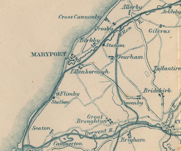 GAR2NY03.jpg
 |
Birkby -- building/s -- NY0637
-- 'Birkby' -- blocks, settlement
Brigham -- building/s -- NY0830 -- 'Brigham' -- blocks, settlement Cockermouth and Workington Railway -- railway -- triple line, light bold light, railway Crosby -- building/s -- NY0738 ? -- 'Crosby' -- blocks, settlement Crosscannonby -- 'Cross Cannonby' -- blocks, settlement Dearham Bridge Station -- railway station -- station -- NY071372 (?) -- 'Station' -- dot by railway probably Dearham -- building/s -- NY0736 -- 'Dearham' -- blocks, settlement Derwent, River -- river -- NY2515 (etc) ? -- 'Derwent R.' -- 'Derwent R.' -- 'Derwent R.' -- 'Derwent R.' -- double wiggly line ... and wiggly line, river Dovenby -- building/s -- NY0933 -- 'Dovenby' -- blocks, settlement Ellen, River -- river -- NY2436 (etc) -- 'Ellen R.' -- Ellenborough -- building/s -- NY0435 -- 'Ellenborough' -- blocks, settlement Flimby Station -- railway station -- station -- NY021338 -- 'Station' -- dot by railway Flimby -- building/s -- NY0233 ? -- 'Flimby' -- blocks, settlement Great Broughton -- building/s -- NY0731 -- 'Great Broughton' -- blocks, settlement Maryport and Carlisle Railway -- railway etc -- 'Whitehaven Maryport & Carlisle Railway' -- triple line, light bold light, railway Maryport -- building/s etc -- NY037366 -- 'MARYPORT' -- blocks, settlement Seaton -- building/s etc -- NY0130 -- 'Seaton' -- blocks, settlement Whitehaven Junction Railway -- railway -- triple line, light bold light, railway | |
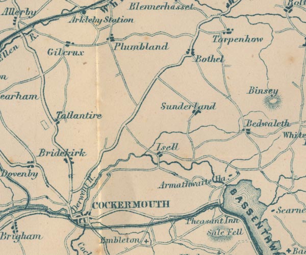 GAR2NY13.jpg
 |
Armathwaite Hall -- building/s -- hotel -- NY207325
-- 'Armathwaite Ha.' -- block, building
Bassenthwaite Lake -- lake -- NY215298 -- 'BASSENTHWAITE WR.' -- outline with shore form lines, lake or tarn Bewaldeth -- building/s -- NY2134 -- 'Bedwaleth' -- blocks, settlement Bothel -- building/s -- NY1838 -- 'Bothel' -- blocks, settlement Bridekirk -- building/s -- NY1133 -- 'Bridekirk' -- blocks, settlement Cockermouth -- building/s etc -- NY122306 -- 'COCKERMOUTH' -- blocks, settlement Cockermouth, Keswick and Penrith Railway -- railway -- triple line, light bold light, railway Dash Beck -- river -- NY2532 (etc) -- wiggly line, river Derwent, River -- river -- NY2515 (etc) ? -- 'Derwent R.' -- 'Derwent R.' -- 'Derwent R.' -- 'Derwent R.' -- double wiggly line ... and wiggly line, river Gilcrux -- building/s -- NY1138 -- 'Gilcrux' -- blocks, settlement Isel -- locality -- NY1633 -- 'Isell' -- blocks, settlement Pheasant, The -- inn -- NY19963070 -- 'Pheasant Inn' -- block, building Plumbland -- building/s -- NY1539 -- 'Plumbland' -- blocks, settlement Cockermouth to Carlisle -- road -- route -- NY13 -- double line, bold light, major road Egremont to Cockermouth -- road -- route -- NY01 -- double line, bold light, major road Keswick to Cockermouth -- road -- route -- NY22 -- double line, bold light, major road Sunderland -- building/s -- NY1735 -- 'Sunderland' -- blocks, settlement Tallentire -- building/s -- NY1035 -- 'Tallantire' -- blocks, settlement Torpenhow -- building/s -- NY2039 -- 'Torpenhow' -- blocks, settlement | |
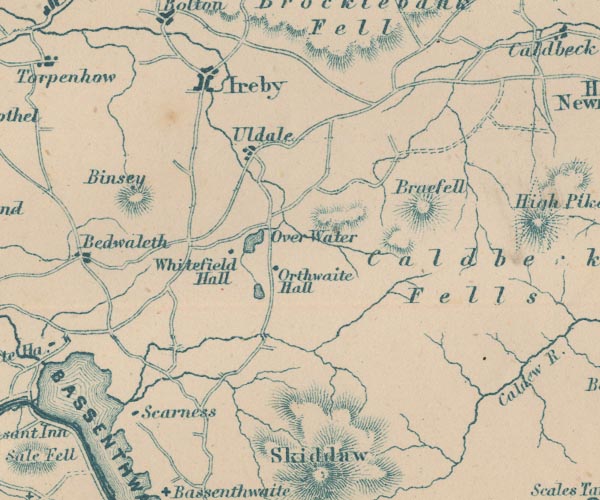 GAR2NY23.jpg
 |
Binsey -- hill -- NY2235
-- 'Binsey' -- hill hachuring
Brae Fell -- hill -- fell -- NY2835 -- 'Braefell' -- hill hachuring Caldbeck Fells -- hill -- fell -- NY3135 (etc) -- 'Caldbeck Fells' -- hill hachuring Ireby -- building/s etc -- NY238388 -- 'Ireby' -- blocks, settlement Orthwaite Hall -- building/s -- house -- NY25263418 -- 'Orthwaite Hall' -- block, building Over Water -- lake -- NY251350 -- 'Over Water' -- outline with shore form lines, lake or tarn Scar Ness -- headland -- locality -- NY213304 -- 'Scarness' -- block, building Uldale -- building/s -- NY2436 -- 'Uldale' -- blocks, settlement Whitefield House -- building/s -- NY2434 -- 'Whitefield Hall' -- block, building | |
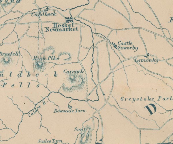 GAR2NY33.jpg
 |
Bowscale Tarn -- lake -- NY3331
-- 'Bowscale Tarn' -- outline with shore form lines, lake
or tarn
Caldew, River -- river -- NY3851 (etc) ? -- 'R. Caldew' -- 'R. Caldew' -- 'Caldew R.' -- wiggly line, river Carrock Fell -- hill -- fell -- NY34153365 -- 'Carrock' -- hill hachuring Castle Sowerby -- locality -- NY3739 (etc) -- 'Castle Sowerby' -- blocks, settlement Hesket Newmarket -- building/s etc -- NY340386 -- 'Hesket Newmarket' -- blocks, settlement High Pike -- hill -- NY319349 -- 'High Pike' -- hill hachuring | |
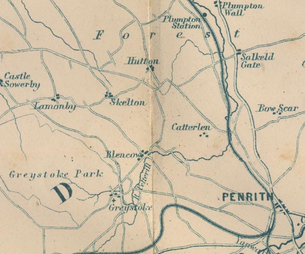 GAR2NY43.jpg
 |
Blencow -- building/s -- NY4532
-- 'Blencow' -- blocks, settlement
Catterlen -- building/s -- NY4833 -- 'Catterlen' -- blocks, settlement Cockermouth, Keswick and Penrith Railway -- railway -- triple line, light bold light, railway Greystoke Castle -- castle -- park -- NY425309 (castle) -- 'Greystoke Park' -- area Greystoke -- building/s -- NY4330 -- 'Greystoke' -- blocks, settlement, cross, a church Hutton End -- building/s -- NY449385 -- 'Hutton' -- blocks, settlement perhaps Lamonby -- building/s -- NY409358 -- 'Lamonby' -- blocks, settlement Lancaster and Carlisle Railway -- railway -- 'Lancaster & Carlisle Railway' -- 'Lancaster & Carlisle Railway' -- triple line, light bold light, railway Petteril, River -- river -- NY4935 (etc etc) -- 'R Petterill' -- 'R. Petterill' -- wiggly line, river Plumpton -- building/s -- NY497371 -- 'Salkeld Gate' -- blocks, settlement Penrith to Carlisle -- route -- road -- NY53 ? -- double line, bold light, major road Skelton -- building/s -- NY4335 -- 'Skelton' -- blocks, settlement St Andrew's Church -- church -- NY44323079 -- cross, a church | |
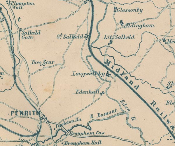 GAR2NY53.jpg
 |
Addingham -- locality -- NY574383
-- 'Aldingham' -- blocks, settlement
Bowscar Farm -- building/s -- locality -- NY514344 -- 'Bow Scar' -- blocks, settlement Briggle Beck -- river -- NY5833 (etc) -- wiggly line, river Carleton Hall -- building/s -- police HQ -- NY525292 (?) -- 'Carleton Ha.' -- block, building Cockermouth, Keswick and Penrith Railway -- railway -- triple line, light bold light, railway Eamont, River -- river -- NY469243 (from) ? ? -- 'R. Eamont' -- 'Eamont R.' -- double wiggly line, and dotted line, the county boundary Eden, River -- river -- NY3658 (etc) -- 'R Eden' -- 'Riv. Eden' -- 'Eden R.' -- river, double line -- part marked as county boundary Edenhall -- building/s -- NY565324 -- 'Edenhall' -- blocks, settlement Great Salkeld -- building/s -- NY5536 -- 'Gt. Salkeld' -- blocks, settlement Lancaster and Carlisle Railway -- railway -- 'Lancaster & Carlisle Railway' -- 'Lancaster & Carlisle Railway' -- triple line, light bold light, railway Langwathby -- building/s -- NY5633 -- 'Longwathby' -- blocks, settlement Little Salkeld -- building/s -- NY566361 -- 'Lit. Salkeld' -- blocks, settlement Penrith -- building/s etc -- NY513304 -- 'PENRITH' -- blocks, settlement Penrith to Carlisle -- route -- road -- NY53 ? -- double line, bold light, major road Shap to Penrith -- route -- road -- NY51 -- double line, bold light, major road Robberby Water -- river -- NY561359 -- wiggly line, river Settle and Carlisle Railway -- railway etc -- 'Midland Railway' -- triple line, light bold light, railway | |
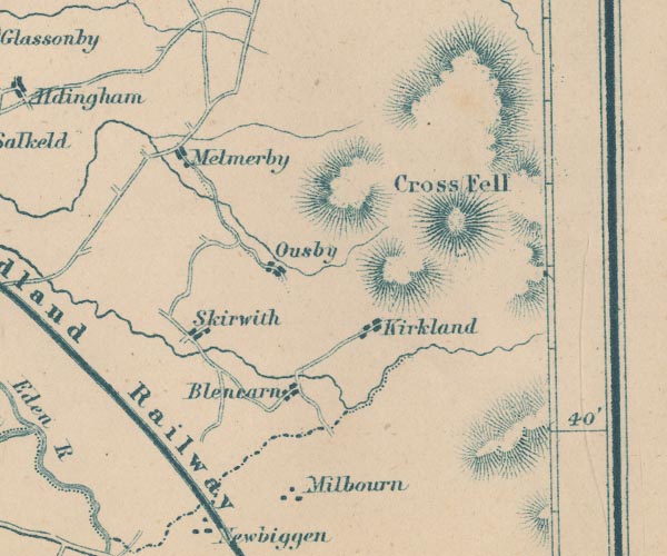 GAR2NY63.jpg
 |
Blencarn -- building/s -- NY6331
-- 'Blencarn' -- blocks, settlement
Cross Fell -- hill -- NY6834 -- 'Cross Fell' -- hill hachuring Kirkland -- building/s -- NY646325 -- 'Kirkland' -- blocks, settlement Melmerby -- building/s -- NY615373 -- 'Melmerby' -- blocks, settlement Milburn -- building/s -- NY6529 -- 'Milbourn' -- blocks, settlement Ousby -- building/s -- NY621348 -- 'Ousby' -- blocks, settlement Settle and Carlisle Railway -- railway etc -- 'Midland Railway' -- triple line, light bold light, railway Skirwith -- building/s -- NY6132 -- 'Skirwith' -- blocks, settlement | |
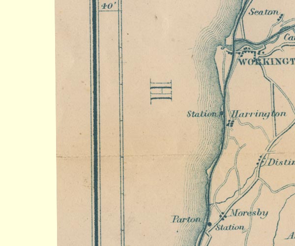 GAR2NX92.jpg
 |
Harrington Station -- railway station -- station --
NX99002537
-- 'Station' -- dot by railway
Harrington -- building/s -- NX9825 -- 'Harrington' -- blocks, settlement Lowca Beck -- river -- NX978212 -- wiggly line, river Moresby -- building/s -- NX9921 -- 'Moresby' -- blocks, settlement Port of Workington -- harbour -- NX9929 -- estuary of the Derwent Whitehaven Junction Railway -- railway -- triple line, light bold light, railway | |
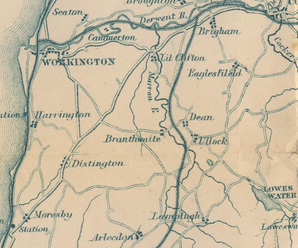 GAR2NY02.jpg
 |
Branthwaite -- building/s -- NY0524
-- 'Branthwaite' -- blocks, settlement
Camerton -- building/s -- NY0330 ? -- 'Cammerton' -- blocks, settlement Cockermouth and Workington Railway -- railway -- triple line, light bold light, railway Dean -- building/s -- NY0725 -- 'Dean' -- blocks, settlement Derwent, River -- river -- NY2515 (etc) ? -- 'Derwent R.' -- 'Derwent R.' -- 'Derwent R.' -- 'Derwent R.' -- double wiggly line ... and wiggly line, river Distington -- building/s -- NY0023 -- 'Distington' -- blocks, settlement Eaglesfield -- building/s -- NY093282 (etc) -- 'Eaglesfield' -- blocks, settlement Lamplugh -- building/s -- NY088207 -- 'Lamplugh' -- blocks, settlement Little Clifton -- building/s -- NY0529 ? -- 'Lit. Clifton' -- blocks, settlement Marron, River -- river -- NY0624 -- 'Marron R.' -- wiggly line, river Egremont to Cockermouth -- road -- route -- NY01 -- double line, bold light, major road Ullock -- building/s -- NY0723 -- 'Ullock' -- blocks, settlement Whitehaven, Cleator and Egremont Railway -- railway -- triple line, light bold light, railway Workington -- building/s etc -- NX996288 -- 'WORKINGTON' -- blocks, settlement | |
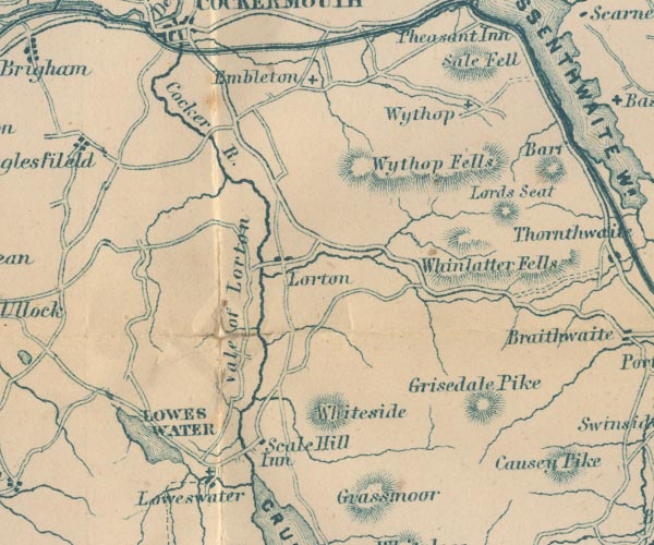 GAR2NY12.jpg
 |
Cocker, River -- river -- NY1426 ?
-- 'Cocker R.' -- wiggly line, river
Embleton -- building/s -- NY1730 -- 'Embleton' -- cross, a church Grisedale Pike -- hill -- NY19852256 (?) -- 'Grisedale Pike' -- hill hachuring High Lorton -- building/s -- NY162257 ? -- 'Lorton' -- blocks, settlement Inn, The -- building/s -- NY150216 -- 'Scale Hill Inn' -- block, building Lord's Seat -- hill -- NY204265 -- 'Lords Seat' -- hill hachuring Lorton Vale -- valley -- NY1526 -- 'Vale of Lorton' -- area Loweswater -- lake -- NY125217 -- 'LOWES WATER' -- outline with shore form lines, lake or tarn Loweswater -- building/s -- NY139208 -- 'Loweswater' -- blocks, settlement, and cross, a church Sale Fell -- hill -- fell -- NY191296 -- 'Sale Fell' -- hill hachuring St Bartholomew's Church -- church -- NY14142095 -- cross, a church St Cuthbert's Church -- church -- NY16262939 -- cross, a church Whinlatter -- hill -- NY19682490 -- 'Whinlatter Fells' -- hill hachuring roughly Whiteside -- hill -- NY17042195 -- 'Whiteside' -- hill hachuring Wythop Brows -- hill -- NY2128 (etc) -- 'Wythop Fells' -- hill hachuring probably Wythop Old Church -- church (ruin) -- chapel (ruin) -- NY19362908 -- cross, a church Wythop -- locality -- NY203284 (etc) -- 'Wythop' -- cross, a church | |
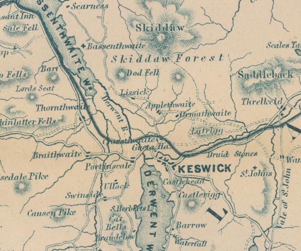 GAR2NY22.jpg
 |
Applethwaite -- building/s -- NY263257
-- 'Applethwaite' -- blocks, settlement
Barf -- hill -- NY21452674 -- 'Barf' -- hill hachuring Bassenthwaite Lake -- lake -- NY215298 -- 'BASSENTHWAITE WR.' -- outline with shore form lines, lake or tarn Bassentwhaite -- 'Bassentwhaite' -- cross, a church Castle Head -- hill -- NY269227 -- 'Castlehead' -- hill hachuring Castlerigg Stone Circle -- stone circle -- NY293236 -- 'Druid Stones' -- no symbol Castlerigg -- building/s -- NY281224 -- 'Castlerigg' -- hill hachuring Cat Bells -- hill -- NY24401986 -- 'Cat Bells' -- hill hachuring Causey Pike -- hill -- NY21872085 -- 'Causey Pike' -- hill hachuring Cockermouth, Keswick and Penrith Railway -- railway -- triple line, light bold light, railway Derwent Water -- lake etc -- NY260210 ? -- 'DERWENT WR.' -- outline with shore form lines, lake or tarn Derwent, River -- river -- NY2515 (etc) ? -- 'Derwent R.' -- 'Derwent R.' -- 'Derwent R.' -- 'Derwent R.' -- double wiggly line ... and wiggly line, river Dodd -- hill -- NY24422735 -- 'Dod Fell' -- hill hachuring probably Great Crosthwaite -- building/s etc -- NY261242 -- 'Crosthwaite' -- blocks, settlement Greta Hall -- building/s -- house -- NY264237 -- 'Greta Ha.' -- block, building Keswick -- building/s etc -- NY266234 -- 'KESWICK' -- blocks, settlement, on a minimal street plan Latrigg -- hill -- NY279247 -- 'Latrigg' -- hill hachuring Lyzzick Hall -- building/s -- NY248262 -- 'Lizzick' -- block, building perhaps Newlands Beck -- river -- NY2319 -- wiggly line, river Ormathwaite -- building/s -- NY267254 -- 'Ormathwaite' -- blocks, settlement Portinscale -- building/s -- NY251235 -- 'Portinscale' -- blocks, settlement Ambleside to Keswick -- road -- route -- NY30 -- double line, bold light, major road Keswick to Cockermouth -- road -- route -- NY22 -- double line, bold light, major road Skiddaw Forest -- forest -- NY2729 (etc) -- 'Skiddaw Forest' -- area Skiddaw -- hill -- NY260290 -- 'Skiddaw' -- hill hachuring St Bega, Bassentwhaite -- cross, a church St Herbert's Island -- island -- NY259212 -- 'St. Herberts I.' -- island Swinside -- hill -- NY24322244 -- 'Swinside' -- blocks, settlement Thornthwaite -- building/s -- NY223254 ? -- 'Thornthwaite' -- blocks, settlement Ullock -- building/s -- NY244230 -- 'Ullock' -- blocks, settlement | |
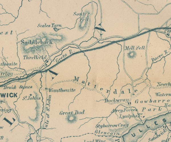 GAR2NY32.jpg
 |
Aira Beck -- river -- NY40001974
-- wiggly line, river
Aira Force -- waterfall -- NY39952048 -- 'Airey Force' -- two lines across a stream, waterfall Cockermouth, Keswick and Penrith Railway -- railway -- triple line, light bold light, railway Dockray -- building/s -- NY392216 -- 'Dockwray' -- blocks, settlement Great Dodd -- hill -- NY34192056 -- 'Great Dod' -- hill hachuring Great Mell Fell -- hill -- NY39672538 -- 'Mell Fell' -- hill hachuring Greta, River -- river -- NY2924 -- 'Greta R.' -- wiggly line, river Lyulph's Tower -- tower -- NY40412020 -- 'Lyulphs Tr.' -- block, building Matterdale Church -- church -- NY39432243 -- cross, a church Matterdale -- locality -- NY3922 (?) -- 'Matterdale' -- area Saddleback -- hill -- NY3127 (etc) -- 'Saddleback' -- hill hachuring Scales Tarn -- lake -- NY328281 -- 'Scales Tarn' -- outline with shore form lines, lake or tarn Souther Fell -- hill -- fell -- NY352287 (etc) -- 'Souter Fell' -- hill hachuring St John's Church -- church -- NY30642246 -- 'St. Johns' -- cross, a church St John's Beck -- river -- NY3123 ? -- wiggly line, river St John's in the Vale -- valley -- NY3122 (etc) -- 'Vale of St. John' -- area Stybarrow Crag -- rocks -- NY386178 -- 'Stybarrow Crag' -- hill hachuring Threlkeld -- building/s -- NY322254 -- 'Threlkeld' -- blocks, settlement Wanthwaite -- building/s -- NY318229 -- 'Wanthwaite' -- blocks, settlement | |
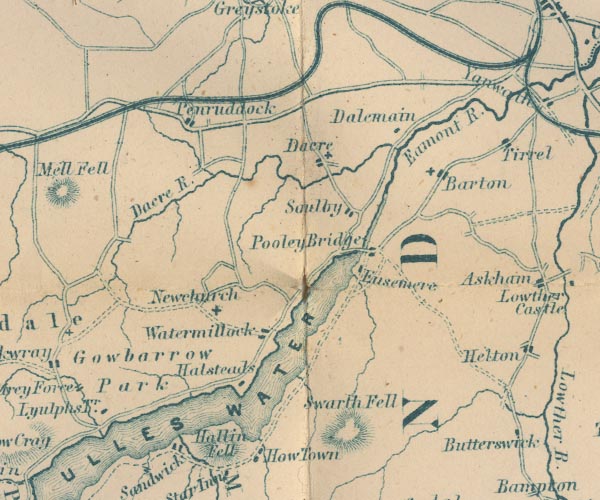 GAR2NY42.jpg
 |
All Saints Church -- church -- NY43142297
-- 'Newchurch' -- cross, a church
Barton -- building/s -- NY486264 -- 'Barton' -- blocks, settlement and a cross, a church Cockermouth, Keswick and Penrith Railway -- railway -- triple line, light bold light, railway Dacre Beck -- river -- NY4626 -- 'Dacre R.' -- wiggly line, river Dacre -- building/s -- NY459265 -- 'Dacre' -- blocks, settlement and a cross, a church Dalemain -- park -- house -- museum -- garden -- NY479269 -- 'Dalemain' -- block, building Eamont, River -- river -- NY469243 (from) ? ? -- 'R. Eamont' -- 'Eamont R.' -- double wiggly line, and dotted line, the county boundary Eusemere -- building/s -- NY46942411 -- 'Eusemere' -- block, building Gowbarrow Park -- park -- NY408212 (etc) -- 'Gowbarrow Park' -- area Hallin Fell -- hill -- fell -- NY43301982 -- 'Hallin Fell' -- hill hachuring Hallsteads -- building/s -- NY43812114 -- 'Halsteads' -- block, building Penruddock -- building/s -- NY429276 -- 'Penruddock' -- blocks, settlement Pooley Bridge -- building/s etc -- NY472244 -- 'Pooley Bridge' -- blocks, settlement Soulby -- building/s -- NY7410 -- 'Soulby' -- blocks, settlement St Andrew's Church -- church -- NY45992663 -- cross, a church St Michael's Church -- church -- NY48742637 -- cross, a church Swarth Fell -- hill -- fell -- NY451198 -- 'Swarth Fell' -- hill hachuring Ullswater -- lake -- NY422202 (etc) ? -- 'ULLES WATER' -- outline with shore form lines, lake or tarn Watermillock -- building/s -- NY445224 -- 'Watermillock' -- blocks, settlement | |
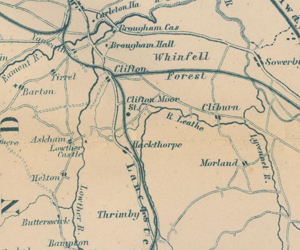 GAR2NY52.jpg
 |
Askham -- building/s -- NY513237
-- 'Askham' -- blocks, settlement
Brougham Castle -- castle -- NY537290 ? -- 'Brougham Cas' -- block, building Brougham Hall -- building/s -- NY52822839 ? -- 'Brougham Hall' -- block, building Butterwick -- building/s -- NY509196 -- 'Butterwick' -- block, building Cliburn -- building/s -- NY5824 -- 'Cliburn' -- blocks, settlement Clifton Station -- railway station -- station -- NY542262 -- 'Clifton Moor St.' -- dot by railway Clifton -- building/s -- NY534266 -- 'Clifton' -- blocks, settlement Eden Valley Railway -- railway -- triple line, light bold light, railway Hackthorpe -- building/s -- NY542232 -- 'Hackthorpe' -- blocks, settlement Helton -- building/s -- NY510220 -- 'Helton' -- blocks, settlement Lancaster and Carlisle Railway -- railway -- 'Lancaster & Carlisle Railway' -- 'Lancaster & Carlisle Railway' -- triple line, light bold light, railway Leith, River -- river -- NY5523 -- 'R Leathe' -- wiggly line, river Lowther Castle -- castle -- NY523238 -- 'Lowther Castle' -- block, building Lowther, River -- river etc -- NY5124 (etc) ? -- 'Lowther R.' -- wiggly line, river Morland -- building/s etc -- NY598225 -- 'Morland' -- blocks, settlement Shap to Penrith -- route -- road -- NY51 -- double line, bold light, major road Thrimby -- building/s -- NY5520 -- 'Thrimby' -- blocks, settlement Tirril -- building/s -- NY5026 -- 'Tirrel' -- blocks, settlement Whinfell Forest -- forest -- wood -- NY5727 (etc) -- 'Whinfell Forest' -- area Yanwath -- building/s -- NY5127 -- 'Yanwath' -- blocks, settlement | |
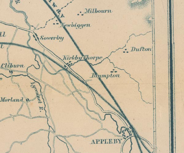 GAR2NY62.jpg
 |
Appleby-in-Westmorland -- building/s etc -- NY684204
-- 'APPLEBY' -- blocks, settlement
Brampton -- building/s -- NY6723 -- 'Brampton' -- blocks, settlement Dufton -- building/s -- NY6825 -- 'Dufton' -- blocks, settlement Eden Valley Railway -- railway -- triple line, light bold light, railway Eden, River -- river -- NY3658 (etc) -- 'R Eden' -- 'Riv. Eden' -- 'Eden R.' -- river, double line -- part marked as county boundary Kirkby Thore -- building/s -- NY638256 -- 'Kirkby Thorpe' -- blocks, settlement Lyvennet, River -- river -- NY6121 (etc) -- 'Lyvennet R.' -- wiggly line, river Newbiggin -- building/s -- NY6228 -- 'Newbiggen' -- blocks, settlement Settle and Carlisle Railway -- railway etc -- 'Midland Railway' -- triple line, light bold light, railway Temple Sowerby -- building/s -- NY6127 -- 'Sowerby' -- blocks, settlement Trout Beck -- river -- boundary -- NY6624 (etc) -- wiggly line, river | |
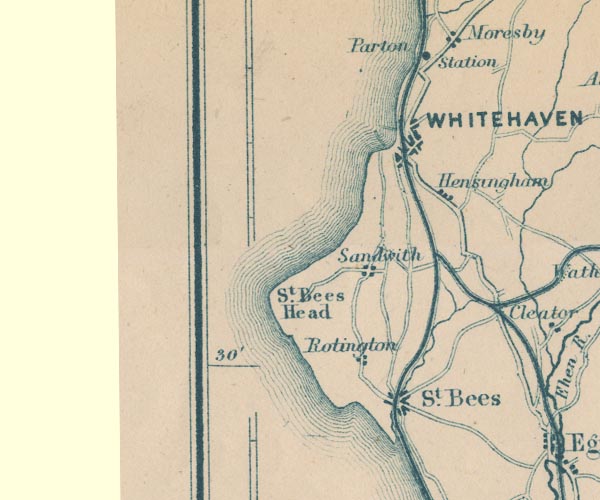 GAR2NX91.jpg
 |
Hensingham -- building/s -- NX9816
-- 'Hensingham' -- blocks, settlement
Parton Station -- railway station -- station -- NX97902062 -- 'Parton Station' -- dot by railway Pow Beck -- river -- NX9712 (etc) -- wiggly line, river Rottington -- building/s -- NX9613 -- 'Rotington' -- blocks, settlement Sandwith -- building/s -- NX9614 -- 'Sandwith' -- blocks, settlement St Bees Head -- headland -- NX940143 (etc) -- 'St. Bees Head' -- headland St Bees -- building/s -- NX971116 -- 'St. Bees' -- blocks, settlement Whitehaven and Furness Junction Railway -- railway -- 'Whitehaven & Furness Junction Raily.' -- triple line, light bold light, railway Whitehaven Junction Railway -- railway -- triple line, light bold light, railway Whitehaven -- building/s etc -- NX974182 -- 'WHITEHAVEN' -- blocks, settlement, and a minimal street plan Whitehaven, Cleator and Egremont Railway -- railway -- triple line, light bold light, railway | |
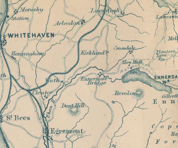 GAR2NY01.jpg
 |
Angler's Inn -- inn (gone) -- NY09481612
-- 'Inn' -- block, building
Arlecdon -- building/s -- NY0419 -- 'Arlecdon' -- blocks, settlement Cleator -- building/s -- NY0113 -- 'Cleator' -- blocks, settlement Croasdale -- building/s -- NY093174 -- 'Crossdale' -- blocks, settlement Dent -- hill -- NY041128 -- 'Dent Hill' -- hill hachuring Dub Beck -- river -- NY0318 (etc) -- wiggly line, river Egremont -- building/s etc -- NY011105 -- 'Egremont' -- blocks, settlement Ehen, River -- river -- NY0515 (etc) ? -- 'Ehen R.' -- wiggly line, river Ennerdale Bridge -- building/s -- NY069159 -- 'Ennerdale Bridge' -- blocks, settlement Ennerdale Water -- lake -- NY106150 -- 'ENNERDALE WR.' -- outline with shore form lines, lake or tarn How Hall Farm -- building/s -- NY09021635 -- 'How Hall' -- block, building Kirkland -- building/s -- NY0717 -- 'Kirkland' -- blocks, settlement Red Moss -- moss -- NY077137 -- outline with shore form lines, lake or tarn Revelin Crag -- rocks -- NY093147 -- 'Revelin' -- hill hachuring Egremont to Cockermouth -- road -- route -- NY01 -- double line, bold light, major road Wath -- locality -- NY027144 -- 'Wath' -- block, building Whitehaven, Cleator and Egremont Railway -- railway -- triple line, light bold light, railway | |
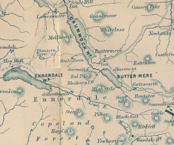 GAR2NY11.jpg
 |
Black Sail Pass -- pass -- NY191114
-- 'Black Sail' -- hill hachuring
Bleaberry Tarn -- lake -- NY165154 ? ? -- 'Bleaberry T.' -- outline with shore form lines, lake or tarn Buttermere -- lake -- NY182158 -- 'BUTTER-MERE' -- outline with shore form lines, lake or tarn Buttermere -- building/s -- locality -- NY175169 -- 'Buttermere' -- blocks, settlement, and cross, a church Copeland Forest -- forest -- NY10 (etc) -- 'Copeland Forest' -- area Crummock Water -- lake -- NY158189 -- 'CRUMMOCK WR.' -- outline with shore form lines, lake or tarn Ennerdale Water -- lake -- NY106150 -- 'ENNERDALE WR.' -- outline with shore form lines, lake or tarn Ennerdale -- valley -- NY1314 (etc) -- 'Ennerdale' -- area Fish Hotel -- inn -- NY17431694 ? -- 'Inn' -- block, building probably Floutern Tarn -- lake -- NY124170 -- 'Floutern Tarn' -- outline with shore form lines, lake or tarn Gatesgarth -- building/s -- locality -- NY19351503 -- 'Gatescarth' -- blocks, settlement Gillerthwaite -- building/s -- NY1314 -- 'Gillerthwaite' -- blocks, settlement Grasmoor -- hill -- NY17492034 -- 'Grassmoor' -- hill hachuring Hassness -- building/s -- NY18681581 -- 'Hassness' -- block, building High Stile -- hill -- NY169147 -- 'High Stile' -- hill hachuring Kirk Fell -- hill -- fell -- NY19491049 -- 'Kirkfell' -- hill hachuring Liza, River -- river -- NY1613 -- 'Liza R.' -- wiggly line, river Mellbreak -- hill -- NY145190 -- 'Melbreak' -- hill hachuring Mosedale -- valley -- NY1710 -- 'Mosdale' -- river valley, between hachuring Pillar -- hill -- NY17121211 -- 'Pillar' -- hill hachuring Red Pike -- hill -- NY165106 -- 'Red Pike' -- hill hachuring Scale Force -- waterfall -- NY150170 -- 'Scale Force' -- two lines across a stream, waterfall Scarth Gap -- pass -- NY189133 -- 'Scarf Gap' -- hill hachuring Scoat Tarn -- lake -- NY159103 -- outline with shore form lines, lake or tarn Sour Milk Gill -- river -- NY1615 -- 'Sourmilk Force' -- two lines across a stream, waterfall St James's Church -- church -- NY17611701 -- cross, a church Steeple -- hill -- NY15731167 -- 'Steeple' -- hill hachuring Whiteless Pike -- hill -- NY180189 -- 'Whiteless' -- hill hachuring | |
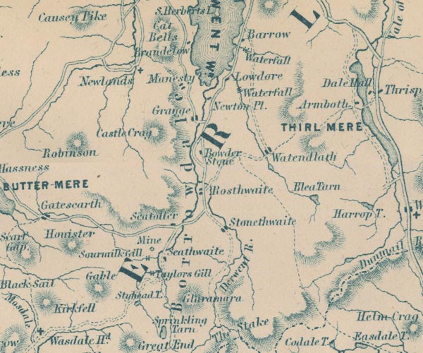 GAR2NY21.jpg
 |
Barrow Cascade -- waterfall -- NY269199
-- 'Waterfall' -- two lines across a stream, waterfall
Barrow House -- building/s -- house -- NY268200 ? -- 'Barrow' -- block, building Wad, The -- black lead mine -- mine -- plumbago mine -- adit -- NY235127 -- 'Mine' -- circle Blea Tarn -- lake -- NY291140 -- 'Blea Tarn' -- outline with shore form lines, lake or tarn Borrowdale -- locality -- valley -- NY2516 (etc) -- 'Borrowdale' -- valley, partly marked by hachures Bowder Stone -- stone -- NY25391640 -- 'Bowder Stone' -- marked by a block Castle Crag -- rocks -- NY249159 -- 'Castle Crag' -- hill hachuring Derwent Water -- lake etc -- NY260210 ? -- 'DERWENT WR.' -- outline with shore form lines, lake or tarn Derwent, River -- river -- NY2515 (etc) ? -- 'Derwent R.' -- 'Derwent R.' -- 'Derwent R.' -- 'Derwent R.' -- double wiggly line ... and wiggly line, river Glaramara -- hill -- NY245104 -- 'Glaramara' -- hill hachuring Grange -- building/s -- NY252174 -- 'Grange' -- blocks, settlement Great Gable -- hill -- NY21101034 -- 'Gable' -- hill hachuring Grisedale Tarn -- lake -- NY348120 ? -- outline, lake or tarn Honister Crag -- rocks -- NY211143 -- 'Honister' -- hill hachuring Lodore Falls -- waterfall -- NY264187 -- 'Waterfall' -- two lines across a stream, waterfall Lodore -- locality -- NY2618 -- 'Lowdore' -- block, building Manesty -- building/s -- NY25021848 -- 'Manesty' -- blocks, settlement Newlands Church -- chapel -- church -- school (ex) -- NY22981934 -- 'Newlands' -- cross, a church Newton Place -- building/s -- NY26061827 -- 'Newton Pl.' -- block, building Old Brandelhow -- building/s -- NY25002065 -- 'Brandelow' -- block, building Robinson -- hill -- NY20171687 -- 'Robinson' -- hill hachuring Rosthwaite -- building/s -- NY259149 ? -- 'Rosthwaite' -- blocks, settlement Seatoller -- building/s -- NY244137 -- 'Seatoller' -- blocks, settlement Sour Milk Gill -- river -- NY2212 -- 'Sourmilk Gill' -- two lines across a stream, waterfall Stonethwaite -- building/s -- NY262137 -- 'Stonethwaite' -- blocks, settlement Styhead Tarn -- lake -- NY221098 -- 'Styhead T.' -- outline with shore form lines, lake or tarn Taylorgill Force -- waterfall -- NY229109 -- 'Taylors Gill' -- two lines across a stream, waterfall Watendlath Tarn -- building/s -- NY275161 -- outline with shore form lines, lake or tarn Watendlath -- building/s -- NY276163 -- 'Watendlath' -- blocks, settlement | |
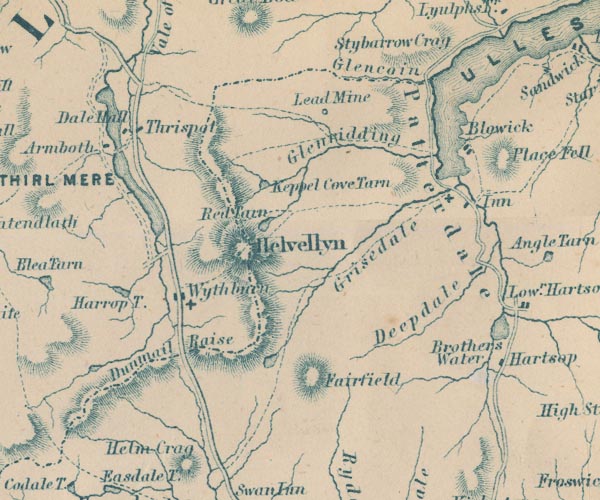 GAR2NY31.jpg
 |
Armboth House -- building/s -- house -- NY305172
-- 'Armboth' -- block, building
Blowick -- building/s -- NY39481738 -- 'Blowick' -- blocks, settlement Brothers Water -- lake -- NY402127 ? -- 'Brothers Water' -- outline with shore form lines, lake or tarn Dalehead Hall -- building/s -- NY31301751 -- 'Dale Hall' -- block, building Deepdale -- valley -- NY3913 -- 'Deepdale' -- river valley Dunmail Raise -- hill -- pass -- NY327117 -- 'Dunmail Raise' -- pass between hachures Fairfield -- hill -- NY35871176 -- 'Fairfield' -- hill hachuring Glencoyne Beck -- river -- boundary -- county boundary -- NY38751881 ? -- wiggly line, river; and county boundary Glencoyne -- valley -- NY3718 (etc) ? -- 'Glencoin' -- river valley Glenridding Beck -- river -- NY35971603 ? -- wiggly line, river Glenridding -- valley -- locality -- NY3717 (etc) -- 'Glenridding' -- river valley Greenside Lead Mine -- lead mine -- silver mine -- mine -- NY365174 -- 'Lead Mine' -- circle Grisedale Beck -- river -- NY36451437 ? -- wiggly line, river Grisedale -- valley -- NY3715 (etc) -- 'Grisedale' -- river valley Harrop Tarn -- lake -- NY311136 -- 'Harrop T.' -- outline with shore form lines, lake or tarn Helvellyn -- hill -- NY34261508 -- 'Helvellyn' -- hill hachuring Keppelcove Tarn -- lake (gone) -- NY346165 -- 'Keppel Cove Tarn' -- outline with shore form lines, lake or tarn Patterdale Hotel -- inn -- NY39561589 ? -- 'Inn' -- block, building Patterdale -- building/s -- NY394160 -- 'Patterdale' -- area Red Tarn -- lake -- NY347152 -- 'Red Tarn' -- outline with shore form lines, lake or tarn Ambleside to Keswick -- road -- route -- NY30 -- double line, bold light, major road St Patrick's Church -- church -- NY39291611 -- cross, a church Thirlmere -- lake -- NY3115 (etc) ? -- 'THIRL MERE' -- outline with shore form lines, lake or tarn Thirlspot -- building/s -- NY317177 -- 'Thirlspot' -- blocks, settlement Ullswater -- lake -- NY422202 (etc) ? -- 'ULLES WATER' -- outline with shore form lines, lake or tarn Wyth Burn -- river -- NY3112 -- wiggly line, river Wythburn Chapel -- church -- chapel -- NY32431358 -- cross, a church Wythburn -- locality -- NY322130 (etc) -- 'Wythburn' -- blocks, settlement, and a cross, a church | |
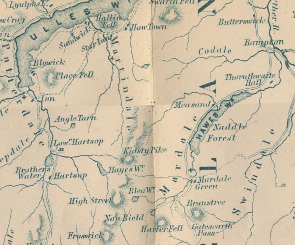 GAR2NY41.jpg
 |
Angle Tarn -- lake -- NY417143
-- 'Angle Tarn' -- outline with shore form lines, lake or
tarn
Blea Water -- lake -- NY448107 -- 'Blea Wr.' -- outline with shore form lines, lake or tarn Branstree -- hill -- NY47820993 -- 'Branstree' -- hill hachuring Cawdale -- valley -- NY482178 (etc) -- 'Codale' -- river valley Hartsop -- building/s -- NY408131 ? ? -- 'Lowr. Hartsop' -- blocks, settlement Hawes Water -- lake -- reservoir -- NY4713 (etc) -- 'HAWES WR.' -- outline with shore form lines, lake or tarn Hayeswater -- lake -- NY431121 ? -- 'Hayes Wr.' -- outline with shore form lines, lake or tarn High Street -- hill etc -- NY441111 (etc) -- 'High Street' -- hill hachuring Holy Trinity Church -- church (flooded) -- NY475117 -- cross, a church Howtown -- building/s -- NY443195 ? -- 'How Town' -- blocks, settlement Kidsty Pike -- hill -- NY44731260 -- 'Kidsty Pike' -- hill hachuring Kirkstonefoot -- locality -- NY403118 -- 'Hartsop' -- block, building perhaps lake, Fusedale -- lake (?) -- NY4517 (?) -- outline with shore form lines, lake or tarn Mardale Green -- building/s -- locality -- NY478117 (etc) -- 'Mardale Green' -- blocks, settlement, and a cross, a church Mardale -- valley -- building/s -- NY473117 (etc) -- 'Mardale' -- area Martindale -- locality -- NY4318 -- 'Martindale' -- area, river valley Measand -- locality -- NY4815 -- 'Measand' -- block, building Naddle Forest -- forest -- NY495145 (etc) ? -- 'Naddle Forest' -- area Nan Bield Pass -- pass -- NY452096 -- 'Nan Bield' -- pass between hachures Place Fell -- hill -- NY40561696 -- 'Place Fell' -- hill hachuring Sandwick -- building/s -- NY42351982 -- 'Sandwicks' -- block, building Small Water -- lake -- NY454100 -- outline with shore form lines, lake or tarn Star Inn -- inn -- NY43371902 (about) -- 'Star Inn' -- block, building | |
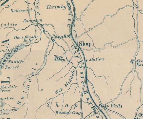 GAR2NY51.jpg
 |
Bampton -- building/s -- NY521180
-- 'Bampton' -- no symbol
Cawdale Beck -- river -- NY4817 -- wiggly line, river Lancaster and Carlisle Railway -- railway -- 'Lancaster & Carlisle Railway' -- 'Lancaster & Carlisle Railway' -- triple line, light bold light, railway Kendal to Shap -- route -- road -- SD59 -- double line, bold light, major road Shap to Penrith -- route -- road -- NY51 -- double line, bold light, major road Rosgill -- building/s -- NY537167 -- 'Rosgill' -- blocks, settlement Shap Abbey -- abbey -- religious house -- NY548153 -- 'Shap Abbey' -- block, building Shap Station -- railway station -- station -- NY5615 -- 'Station' -- dot by railway Shap Wells Hotel -- inn -- NY578095 -- 'Shap Wells' -- no symbol Shap -- building/s etc -- NY562153 -- 'Shap' -- blocks, settlement Sleddale Beck -- river -- NY5109 -- wiggly line, river Swindale Beck -- river -- NY535164 -- wiggly line, river Swindale -- valley -- NY5113 (etc) -- 'Swindale' -- area, river valley Thornthwaite Hall -- building/s -- NY512163 -- 'Thornthwaite Hall' -- block, building Wet Sleddale -- valley -- NY5411 (etc) -- 'Wet Sleddale' -- river valley | |
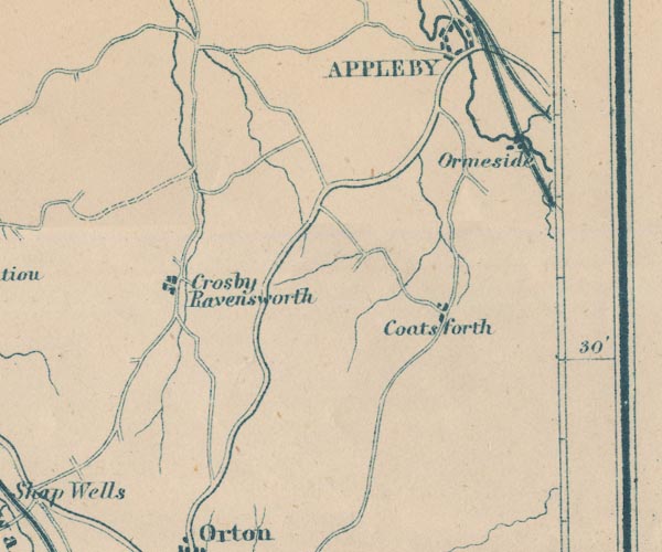 GAR2NY61.jpg
 |
Coatsforth -- locality -- township -- NY695124 (etc,
roughly)
-- 'Coatsforth' -- blocks, settlement
Crosby Ravensworth -- building/s -- NY622148 -- 'Crosby Ravensworth' -- blocks, settlement Eden Valley Railway -- railway -- triple line, light bold light, railway Great Ormside -- building/s -- NY7017 -- 'Ormeside' -- blocks, settlement Settle and Carlisle Railway -- railway etc -- 'Midland Railway' -- triple line, light bold light, railway | |
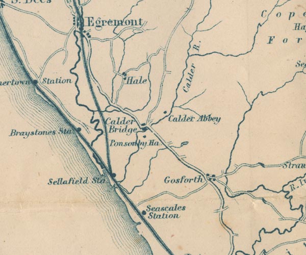 GAR2NY00.jpg
 |
Braystones Station -- railway station -- station --
NY00090599
-- 'Braystones Sta' -- dot by railway
Calder Abbey -- abbey -- religious house -- NY05200647 -- 'Calder Abbey' -- block, building Calder Bridge -- building/s -- NY041060 ? -- 'Calder Bridge' -- blocks, settlement Calder, River -- river etc -- NY0712 (etc) ? -- 'Calder R.' -- wiggly line, river Egremont and Sellafield branch railway -- railway -- triple line, light bold light, railway Gosforth -- building/s -- NY070035 -- 'Gosforth' -- blocks, settlement Hale -- building/s -- NY00 -- 'Hale' -- blocks, settlement lake, Ponsonby -- lake (?) -- marsh (?) -- NY055048 -- outline with shore form lines, lake or tarn Ponsonby Old Hall -- building/s -- NY056050 -- 'Ponsonby Hall' -- block, building Seascale Station -- railway station -- station -- NY03700108 -- 'Seascales Station' -- dot by railway Sellafield Station -- railway station -- station -- NY021034 -- 'Sellafield Sta' -- dot by railway Whitehaven and Furness Junction Railway -- railway -- 'Whitehaven & Furness Junction Raily.' -- triple line, light bold light, railway | |
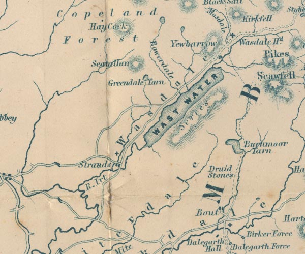 GAR2NY10.jpg
 |
Bleng, River -- river -- NY1108
-- wiggly line, river
Boot -- building/s -- NY176010 -- 'Bout' -- blocks, settlement Bowderdale -- valley -- NY1607 (etc) -- 'Bowerdale' -- river valley Burnmoor Stone Circles -- stone circle -- NY171027 (circle A) -- 'Druid Stones' -- no symbol Burnmoor Tarn -- lake -- NY183043 ? -- 'Burnmoor Tarn' -- outline with shore form lines, lake or tarn Greendale Tarn -- lake -- NY147074 -- 'Greendale Tarn' -- outline with shore form lines, lake or tarn Haycock -- hill -- NY14471071 -- 'Hay Cock' -- hill hachuring Irt, River -- river etc -- NY1002 (etc) ? -- 'R. Irt' -- wiggly line, river Low Tarn -- lake -- NY161092 -- outline with shore form lines, lake or tarn Nether Wasdale -- building/s -- locality -- NY1204 (etc) -- 'Strands' -- cross, a church Screes, The -- scree -- NY1504 -- 'Screes' -- hill hachuring Seatallan -- hill -- NY13960841 -- 'Seatallan' -- hill hachuring St Catherine's Church -- church -- NY17580025 -- cross, a church St Michael and All Angels Church -- church -- NY125041 -- cross, a church St Olaf's Church -- church -- NY18850869 -- cross, a church Wasdale Head -- building/s -- NY186088 -- 'Wasdale Hd.' -- cross, a church Wasdale -- valley -- NY1606 (etc etc) -- 'Wasdale' -- area Wast Water -- lake -- NY161059 -- 'WAST WATER' -- outline with shore form lines, lake or tarn Whillan Beck -- river -- NY1803 (etc) -- wiggly line, river Yewbarrow -- hill -- NY173085 -- 'Yewbarrow' -- hill hachuring | |
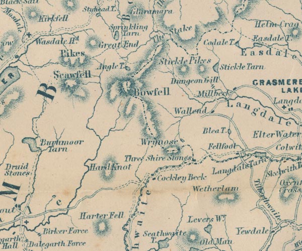 GAR2NY20.jpg
 |
Angle Tarn -- lake -- NY244076
-- 'Angle T.' -- outline with shore form lines, lake or
tarn
Blea Tarn -- lake -- NY292043 -- 'Blea T.' -- outline with shore form lines, lake or tarn Bow Fell -- hill -- fell -- NY24460645 -- 'Bowfell' -- hill hachuring Cockley Beck -- building/s -- NY247016 -- 'Cockley Beck' -- block, building Codale Tarn -- lake -- NY296088 -- 'Coldale T.' -- outline with shore form lines, lake or tarn Dungeon Ghyll Force -- waterfall -- NY290065 -- 'Dungeon Gill' -- two lines across a stream, waterfall Fell Foot -- building/s -- inn (ex) -- NY29890319 -- 'Fellfoot' -- block, building Great End -- hill -- NY225084 -- 'Great End' -- hill hachuring Hard Knott -- hill -- NY23180237 -- 'Hard Knot' -- hill hachuring Harter Fell -- hill -- SD21849971 -- 'Harter Fell' -- hill hachuring Langdale Pikes -- hill -- NY2707 -- 'Stickle Pikes' -- hill hachuring Millbeck -- locality -- NY295066 -- 'Millbeck' -- block, building Red Tarn -- lake -- NY268037 -- outline with shore form lines, lake or tarn Sca Fell -- hill -- NY20680651 (?) -- 'Pikes / Scawfell' -- hill hachuring Scafell Pike -- hill -- NY21550722 -- 'Pikes / Scawfell' -- hill hachuring Sprinkling Tarn -- lake -- NY228091 -- 'Sprinkliing Tarn' -- outline with shore form lines, lake or tarn Stake Pass -- pass -- NY26530869 (pile of stones) -- 'The Stake' -- pass, between hachures Stickle Tarn -- lake -- NY287076 -- 'Stickle Tarn' -- outline with shore form lines, lake or tarn Three Shire Stones -- boundary stone -- stone -- county boundary mark -- NY27720274 ? -- 'Three Shire Stones' -- block; at meet of county boundaries Wall End -- building/s -- NY28300553 -- 'Wallend' -- block, building Wetherlam -- hill -- NY28780109 (?) -- 'Wetherlam' -- hill hachuring Wrynose Fell -- hill -- fell -- NY2704 -- 'Wrynose' -- hill hachuring | |
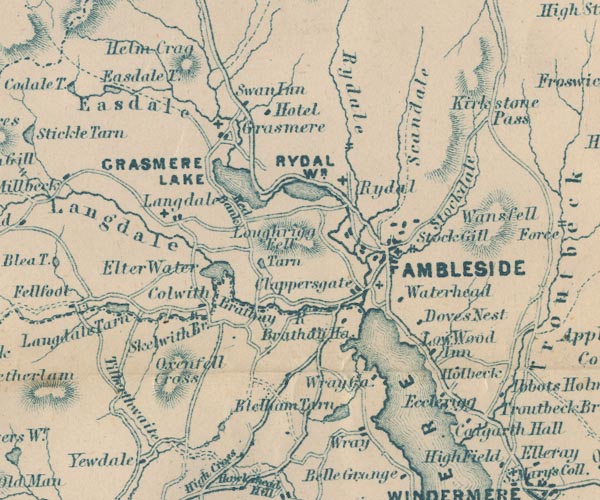 GAR2NY30.jpg
 |
Ambleside -- building/s etc -- NY376045 ?
-- 'AMBLESIDE' -- blocks, settlement, and two crosses, the
old and new churches
Blelham Tarn -- lake -- NY365004 -- 'Blelham Tarn' -- outline with shore form lines, lake or tarn Brathay Hall -- building/s -- park -- NY36660312 -- 'Brathay Ha.' -- block, building Brathay, River -- river -- NY3503 -- 'Brathay R.' -- wiggly line, river; and county boundary Buckstones Jump -- waterfall -- NY36690776 (?) -- two lines across a stream, waterfall Calgarth Hall -- building/s -- SD398996 ? -- 'Calgarth Hall' -- block, building Chapel Stile -- building/s -- NY317054 -- 'Langdale' -- blocks, settlement, and a cross, a church Clappersgate -- building/s -- NY366033 -- 'Clappersgate' -- blocks, settlement Colwith -- building/s -- NY330031 -- 'Colwith' -- bdg Dove Nest -- building/s -- NY38410255 -- 'Doves Nest' -- block, building Easedale Tarn -- lake -- NY307087 (etc) -- 'Easedale T.' -- outline with shore form lines, lake or tarn Easedale -- valley -- NY3208 -- 'Easedale' -- river valley Ecclerigg House -- building/s -- NY38820124 -- 'Ecclerigg' -- block, building Elter Water -- lake -- NY333041 -- 'Elter Water' -- outline with shore form lines, lake or tarn Grasmere Lake -- 'GRASMERE LAKE' -- outline with shore form lines, lake or tarn Grasmere -- building/s -- NY336075 ? -- 'Grasmere' -- blocks, settlement, and a cross, a church Great Langdale -- valley -- NY3006 (etc) -- 'Langdale' -- river valley Helm Crag -- hill -- NY32670930 -- 'Helm Crag' -- hill hachuring High Wray -- building/s -- SD372999 -- 'Wray' -- blocks, settlement Holbeck Ghyll -- building/s -- NY392023 -- 'Holbeck' -- block, building Holy Trinity Church -- church -- NY32090547 -- cross, a church inn, Grasmere -- inn -- NY34310846 -- 'Hotel' -- block, building Kirkstone Pass -- pass -- NY401080 -- 'Kirkstone Pass' -- pass, partly indicated by hachuires, and roads Little Langdale Tarn -- lake -- NY309032 -- 'Langdale Tarn' -- outline with shore form lines, lake or tarn Loughrigg Fell -- hill -- fell -- NY3405 -- 'Loughrigg Fell' -- hill hachuring Loughrigg Tarn -- lake -- NY344043 -- 'Tarn' -- lak Low Wood Hotel -- inn -- NY38560207 -- 'Low Wood Inn' -- block, building Oxen Fell -- hill -- fell -- NY325016 (roughly ?) -- 'Oxenfell Cross' -- hill hachuring possibly Red Bank -- hill (?) -- NY339058 -- 'Red Bank' -- stretch of road Ambleside to Keswick -- road -- route -- NY30 -- double line, bold light, major road Windermere to Ambleside -- road -- route -- SD49 -- double line, bold light, major road Rothay, River -- river -- NY3308 (etct) -- wiggly line, river Rydal Beck -- river -- NY365084 (etc) -- wiggly line, river Rydal Fell -- hill -- fell -- valley -- NY3609 -- 'Rydale' -- river valley Rydal Water -- lake -- NY355061 -- 'RYDAL WR.' -- outline with shore form lines, lake or tarn Rydal -- building/s -- NY364062 -- 'Rydal' -- cross, a church Scandale -- valley -- NY3707 (etc) -- 'Scandale' -- river valley Skelwith Bridge bridge -- bridge -- NY34430337 -- 'Skelwith Br.' -- road crosses stream St Anne's Church -- church (ex) -- building/s -- NY37750467 -- notice two crosses, the old and new churches St Mary's Church -- church -- NY37400436 -- notice two crosses, the old and new churches St Mary, Rydal, Lakes -- cross, a church St Oswald's Church -- church -- NY33730735 -- cross, a church Stock Gill -- 'Stock Gill' -- two lines across a stream, waterfall Stockdale -- valley -- NY3939 (etc) -- 'Stockdale' -- river valley (Stock Beck) Swan Hotel -- inn (hotel) -- NY339083 -- 'Swan Inn' -- block, building Tilberthwaite -- locality -- NY308012 (etc) -- 'Tilberthwaite' -- area Waterhead -- building/s -- NY375034 -- 'Waterhead' -- block, building Windermere lake -- lake -- SD392950 ? -- 'WINDER MERE' -- outline with shore form lines, lake or tarn Wray Castle -- castle -- NY37490103 -- 'Wray Ca.' -- block, building | |
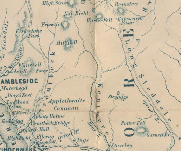 GAR2NY40.jpg
 |
Applethwaite Common -- common -- NY4202
-- 'Applethwaite Common' -- area
Froswick -- hill -- NY43520852 -- 'Froswick' -- hill hachuring Gatescarth Pass -- pass -- cirque (at head) -- NY47390927 -- 'Gatescarth Pass' -- pass between hachures Harter Fell -- hill -- fell -- NY459093 -- 'Harter Fell' -- hill hachuring Ibbotsholme -- building/s (? still?) -- NY40260057 -- 'Abbots Holme' -- block, building probably Ill Bell -- hill -- NY43650774 -- 'Hill Bell' -- hill hachuring Kent, River -- river etc -- NY4506 (etc) -- 'Kent R.' -- 'R. Kent' -- wiggly line, river Kentmere -- valley -- NY457040 (etc) -- 'Kentmere' -- river valley Longsleddale -- valley -- NY4904 (etc) -- 'Long Sleddale' -- river valley Potter Fell -- hill -- fell -- SD5099 & SD5199 -- 'Potter Fell' -- hill hachuring Skeggles Water -- lake -- NY479034 -- 'Skeggles Wr.' -- outline with shore form lines, lake or tarn Sprint, River -- river etc -- NY4806 (etc) -- 'Sprint R.' -- wiggly line, river Trout Beck -- river -- NY4104 (etc) ? -- wiggly line, river Troutbeck Bridge -- bridge -- NY40310035 -- 'Troutbeck Bridge' -- no symbol, road crosses stream Troutbeck -- building/s -- locality -- valley -- NY4103 -- 'Troutbeck' -- river valley waterfall, Troutbeck -- waterfall -- NY420055 (bout) -- 'Force' -- two lines across a stream, waterfall | |
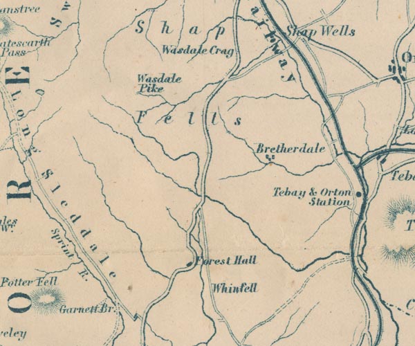 GAR2NY50.jpg
 |
Borrow Beck -- river -- NY5503
-- wiggly line, river
Bretherdale -- valley -- locality -- NY5705 (etc) -- 'Bretherdale' -- blocks, settlement Forest Hall -- building/s -- NY54810126 ? -- 'Forest Hall' -- block, building Garnett Bridge -- bridge -- SD52369927 ? -- 'Garnett Br.' -- road crosses stream Lancaster and Carlisle Railway -- railway -- 'Lancaster & Carlisle Railway' -- 'Lancaster & Carlisle Railway' -- triple line, light bold light, railway Kendal to Shap -- route -- road -- SD59 -- double line, bold light, major road Shap Fells -- hill -- fell -- NY5309 -- 'Shap Fells' -- area Wasdale Crag -- rocks -- NY558084 -- 'Wasdale Crag' -- no symbol Wasdale Pike -- hill -- NY53610846 -- 'Wasdale Pike' -- no symbol Whinfell -- locality -- NY5700 -- 'Whinfell' -- no symbol | |
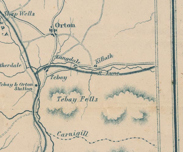 GAR2NY60.jpg
 |
Carlin Gill -- valley -- SD6399 (etc)
-- 'Carnigill' -- labelled beside the county boundary
Kelleth -- building/s -- NY661052 -- 'Killath' -- blocks, settlement Lancaster and Carlisle Railway -- railway -- 'Lancaster & Carlisle Railway' -- 'Lancaster & Carlisle Railway' -- triple line, light bold light, railway Longdale -- building/s -- NY644041 -- 'Langdale' -- blocks, settlement probably Lune, River -- river etc -- NY6205 (etc) -- 'R. Lune' -- 'R. Lune' -- 'R. Lune' -- wiggly line, river -- double wiggly line Orton -- building/s etc -- NY621083 -- 'Orton' -- blocks, settlement South Durham and Lancashire Union Railway -- railway etc -- triple line, light bold light, railway Tebay Fell -- hill -- fell -- NY6202 (etc) -- 'Tebay Fells' -- hill hachuring Tebay Station -- railway station -- station -- NY6104 (?) -- 'Tebay & Orton Station' -- dot by railway Tebay -- building/s -- NY616045 -- 'Tebay' -- blocks, settlement | |
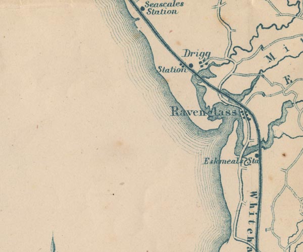 GAR2SD09.jpg
 |
Drigg Station -- railway station -- station --
SD06329890
-- 'Station' -- dot by railway
Drigg -- building/s -- SD0698 -- 'Drigg' -- blocks, settlement Esk Estuary (?) -- estuary -- river estuary -- SD0896 -- area Esk, River -- river -- NY2101 (etc) ? -- 'R. Esk' -- wiggly line, river, broadening into the estuary Irt, River -- river etc -- NY1002 (etc) ? -- 'R. Irt' -- wiggly line, river Ravenglass -- building/s etc -- SD085964 -- 'Ravenglass' -- blocks, settlement Whitehaven and Furness Junction Railway -- railway -- 'Whitehaven & Furness Junction Raily.' -- triple line, light bold light, railway | |
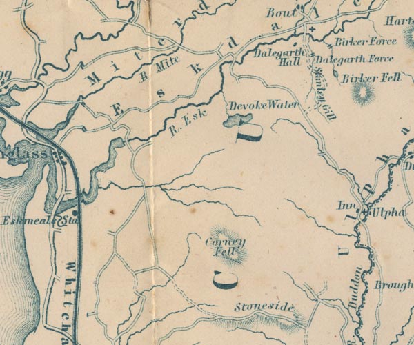 GAR2SD19.jpg
 |
Birker Force -- waterfall -- SD18759993 (?)
-- 'Birker Force' -- two lines across a stream, waterfall
Corney Fell -- hill -- fell -- SD1391 -- 'Corney Fell' -- hill hachuring Dalegarth Hall -- building/s -- NY169001 ? -- 'Dalegarth Hall' -- block, building Devoke Water -- lake -- SD158969 -- 'Devoke Water' -- outline with shore form lines, lake or tarn Esk, River -- river -- NY2101 (etc) ? -- 'R. Esk' -- wiggly line, river, broadening into the estuary Eskdale -- valley -- locality -- NY1802 (etc) -- 'Eskdale' -- river valley Eskmeals Station -- railway station -- station -- SD0893 (?) -- 'Eskmeals Sta' -- dot by railway Low Birker Tarn -- lake -- SD19029949 -- outline with shore form lines, lake or tarn Mite, River -- river etc -- NY1602 -- 'R. Mite' -- wiggly line, river Miterdale -- valley -- NY1501 -- 'Miterdale' -- river valley Stanley Force -- waterfall -- SD17429948 (etc) -- 'Dalegarth Force' -- two lines across a stream, waterfall Stanley Gill -- river -- SD1799 (etc) -- 'Stanley Gill' -- wiggly line, river Whitehaven and Furness Junction Railway -- railway -- 'Whitehaven & Furness Junction Raily.' -- triple line, light bold light, railway | |
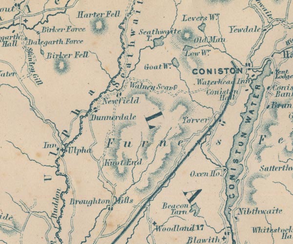 GAR2SD29.jpg
 |
Beacon Tarn -- lake -- SD273900
-- 'Beacon Tarn' -- outline with shore form lines, lake or
tarn
Birker Fell -- hill -- fell -- SD173975 (etc) -- 'Birker Fell' -- hill hachuring Blind Tarn -- lake -- SD262967 -- outline with shore form lines, lake or tarn probably Broughton Mills -- building/s -- SD222905 -- 'Broughton Mills' -- blocks, settlement Coniston Hall -- building/s -- SD30449634 -- 'Coniston Hall' -- block, building Coniston Railway -- railway -- triple line, light bold light, railway Coniston Water -- lake -- SD302943 -- 'CONISTON WATER' -- outline with shore form lines, lake or tarn Duddon, River -- river -- NY2602 (etc) -- 'R. Duddon' -- wiggly line, river, broadening at its foot; and county boundary Dunnerdale -- valley -- SD2093 (etc) -- 'Ulpha' -- area, river valley Furness Fells -- hill -- fell -- SD3389 (etc) -- 'Furness Fells' -- area, hill hachuring Goat's Water -- lake -- SD266976 -- 'Goat Wr.' -- outline with shore form lines, lake or tarn Hall Dunnerdale -- building/s -- SD214954 -- 'Dunnerdale' -- blocks, settlement High Nibthwaite -- building/s -- SD293897 -- 'Nibthwaite' -- block, building Plough -- inn (gone) -- SD1993 -- 'Inn' -- block, building Knott End -- hill -- SD224916 -- 'Knot End' -- hill hachuring Levers Water -- lake -- SD279992 -- 'Levers Wr.' -- outline with shore form lines, lake or tarn Low Water -- lake -- SD274982 -- 'Low Wr.' -- outline with shore form lines, lake or tarn Newfield -- locality -- SD227959 (etc) -- 'Newfield' -- blocks, settlement Old Man of Coniston, The -- hill -- SD27239782 -- 'Old Man' -- hill hachuring Oxen House -- building/s -- SD290921 -- 'Oxen Ho.' -- block, building Seathwaite Fells -- hill -- fell -- SD2597 -- 'Seathwaite' -- area, river valley Seathwaite Tarn -- lake -- SD253988 -- 'Seathwaite T.' -- outline with shore form lines, lake or tarn St John's Church -- church -- SD19799325 -- cross, a church Torver -- building/s -- SD283941 -- 'Torver' -- blocks, settlement Ulpha -- building/s -- SD197932 (etc) -- 'Ulpha' -- cross, a church Walna Scar -- hill -- SD256962 (etc) -- 'Walney Scar' -- no symbol | |
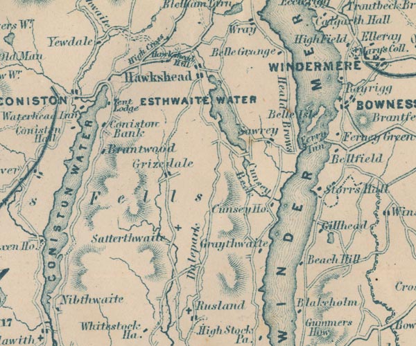 GAR2SD39.jpg
 |
All Saints Church -- church -- SD33879263
-- cross, a church
Beech Hill Farm -- building/s -- SD388919 ? -- 'Beach Hill' -- block, building Belle Grange -- building/s -- SD387989 ? -- 'Belle Grange' -- block, building Belle Isle -- island -- SD393967 ? -- 'Belle Isle' -- island Blake Holme -- building/s -- SD38468985 -- 'Blakeholm' -- block, building Bowness-on-Windermere -- building/s etc -- SD403969 ? ? -- 'BOWNESS' -- set, and a cross, a church Brantwood -- museum -- house -- garden -- SD31259584 -- 'Brantwood' -- block, building Coniston Water -- lake -- SD302943 -- 'CONISTON WATER' -- outline with shore form lines, lake or tarn Coniston -- building/s etc -- SD302978 -- 'CONISTON' -- blocks, settlement Cunsey Beck -- river -- boundary -- parish boundary -- SD3694 -- 'Cunsey Beck' -- wiggly line, river Dale Park -- park -- SD3592 (etc) -- 'Dalepark' -- area Esthwaite Water -- lake -- SD3696 (etc) -- 'ESTHWAITE WATER' -- outline with shore form lines, lake or tarn Far Sawrey -- building/s -- SD378954 -- 'Sawrey' -- blocks, settlement Ferney Green -- building/s -- SD405960 -- 'Ferney Green' -- block, building Ferry House, The -- inn -- building/s -- SD39049565 -- 'Ferry Inn' -- no symbol Furness Fells -- hill -- fell -- SD3389 (etc) -- 'Furness Fells' -- area, hill hachuring Ghyll Head Reservoir -- reservoir -- tarn (once) -- SD397922 (etc) -- outline with shore form lines, lake or tarn Ghyll Head -- building/s -- SD393927 -- 'Gillhead' -- block, building Graythwaite Hall -- building/s -- SD371913 -- 'Graythwaite' -- block, building probably Grizedale -- building/s -- SD335943 -- 'Grizedale' -- blocks, settlement Hawkshead Old Hall -- building/s -- SD3498 -- 'Hawkshead Hall' -- blocks, settlement Hawkshead -- building/s etc -- SD351980 -- 'Hawkshead' -- blocks, settlement Heald, The -- area -- SD384979 (etc) -- 'Heald Brows' -- area High Bank Ground -- building/s -- SD31599703 -- 'Coniston Bank' -- block, building possibly High Cross -- SD33219862 -- 'High Cross' -- area, or a road High Yewdale -- building/s -- SD31489973 -- 'Yewdale' -- block, building probably Highfield -- building/s -- SD40549923 -- 'High Field' -- block, building Low Bank Ground -- building/s -- SD31599694 -- 'Coniston Bank' -- block, building possibly Low Cunsey Farm -- building/s -- SD37949325 -- 'Cunsey Ho.' -- block, building Out Dubs Tarn -- lake -- SD367948 -- outline with shore form lines, lake or tarn Satterthwaite -- building/s -- SD338923 -- 'Satterthwaite' -- cross, a church St Martin's Church -- church -- SD40259688 -- cross, a church Storrs Hall -- building/s -- house -- SD392941 -- 'Storrs Hall' -- block, building Tent Lodge -- building/s etc -- SD317974 -- 'Tent Lodge' -- block, building Waterhead Inn -- inn -- SD3197 (?) ? -- 'Waterhead Inn' -- block, building Windermere Ferry (?) -- ferry -- SD39109569 & SD39579581 -- 'Ferry' -- dotted line across lake Windermere lake -- lake -- SD392950 ? -- 'WINDER MERE' -- outline with shore form lines, lake or tarn | |
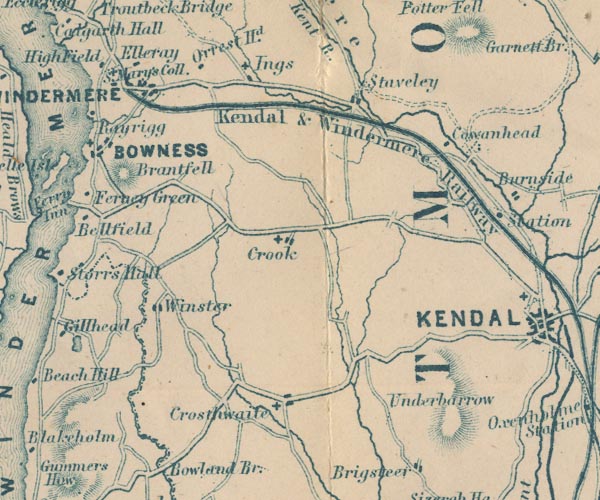 GAR2SD49.jpg
 |
Brant Fell -- hill -- SD409961
-- 'Brantfell' -- hill hachuring
Cowan Head -- building/s -- SD492973 -- 'Cowanhead' -- block, building Crook -- building/s -- SD464951 -- 'Crook' -- blocks, settlement, and a cross, a church Crosthwaite -- building/s -- SD437915 -- 'Crosthwaite' -- blocks, settlement, and a cross, a church Elleray -- building/s -- school -- SD411989 -- 'Elleray' -- block, building Holy Trinity Church -- church -- SD417930 -- cross, a church Ings -- building/s -- SD445986 -- 'Ings' -- block, building, and a cross, a church Kendal and Windermere Railway -- railway -- 'Kendal & Windermere Railway' -- triple line, light bold light, railway Orrest Head -- building/s -- SD41569870 -- 'Orrest Hd.' -- block, building Rayrigg Hall -- building/s -- SD40289811 -- 'Rayrigg' -- blocks, settlement Kendal to Windermere -- road -- route -- SD59 St Anne's Church -- church -- SD44599863 -- cross, a church St Catherine's Church -- church -- SD45099506 -- cross, a church St Mary's Church -- church -- SD44599113 -- cross, a church St Mary's Church -- church -- SD41009872 -- cross, a church St Mary's College -- school -- SD41009859 -- 'S. Mary's Coll.' -- no sepearte symbol Staveley -- building/s etc -- SD470984 -- 'Staveley' -- blocks, settlement Underbarrow -- building/s -- SD465922 -- 'Underbarrow' -- no symbol, or hill hachures for the scar? Windermere -- building/s etc -- SD412985 -- 'WINDERMERE' -- blocks, settlement, and a cross, a church Winster -- building/s -- SD418935 -- 'Winster' -- blocks, settlement, and a cross, a church | |
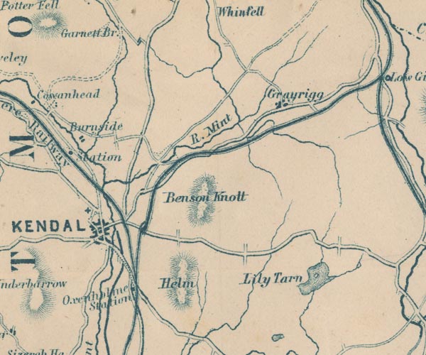 GAR2SD59.jpg
 |
Benson Knott -- hill -- SD5494
-- 'Benson Knott' -- hill hachuring
Burneside Station -- railway station -- station -- SD50249580 -- 'Station' -- dot by railway Burneside -- building/s -- SD505955 -- 'Burneside' -- blocks, settlement Grayrigg -- building/s -- SD578972 -- 'Grayrigg' -- blocks, settlement Helm, The -- hill -- SD53378956 -- 'Helm' -- hill hachuring Kendal and Windermere Railway -- railway -- 'Kendal & Windermere Railway' -- triple line, light bold light, railway Kendal -- building/s etc -- SD514926 -- 'KENDAL' -- blocks, settlement, on a minimal street plan Lancaster and Carlisle Railway -- railway -- 'Lancaster & Carlisle Railway' -- 'Lancaster & Carlisle Railway' -- triple line, light bold light, railway Lancaster Canal -- canal etc -- SD58 (etc) -- bold line Lily Mere -- lake -- SD604915 -- 'Lily Tarn' -- outline with shore form lines, lake or tarn Mint, River -- river -- SD5596 -- 'R. Mint' -- wiggly line, river Oxenholme Station -- railway station -- station -- railway junction -- junction -- SD532902 -- 'Oxenholme Station' -- dot by railway Kendal to Shap -- route -- road -- SD59 -- double line, bold light, major road Kendal to Windermere -- road -- route -- SD59 Lancaster to Kendal -- route -- road etc -- SD46 -- double line, bold light, major road Sprint, River -- river etc -- NY4806 (etc) -- 'Sprint R.' -- wiggly line, river | |
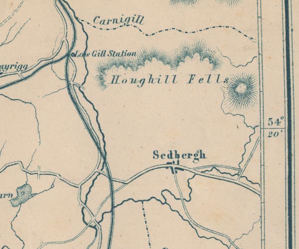 GAR2SD69.jpg
 |
Dee, River -- river -- SD7186 (etc etc) ?
-- wiggly line, river
Howgill Fells -- hill -- SD6699 (and lots more) -- 'Houghill Fells' -- hill hachuring Lancaster and Carlisle Railway -- railway -- 'Lancaster & Carlisle Railway' -- 'Lancaster & Carlisle Railway' -- triple line, light bold light, railway Low Gill and Ingleton branch railway (?) -- railway etc -- triple line, light bold light, railway Low Gill Station -- railway station -- station -- SD6297 (?) -- 'Low Gill Station' -- dot by railway Lune, River -- river etc -- NY6205 (etc) -- 'R. Lune' -- 'R. Lune' -- 'R. Lune' -- wiggly line, river -- double wiggly line Rawthey, River -- river -- SD6894 (etc etc) ? -- wiggly line, river Sedbergh -- building/s etc -- SD662921 -- 'Sedbergh' -- blocks, settlement | |
 GAR2SD18.jpg
 |
Annas, River -- river -- SD0887 (etc)
-- wiggly line, river
Black Beck -- river -- SD1886 -- wiggly line, river Black Combe -- hill -- SD135855 (summit) -- 'Black Comb' -- hill hachuring Bootle -- building/s etc -- SD108883 -- 'Bootle' -- blocks, settlement Millom Castle -- castle -- SD171813 -- 'Millom' -- blocks, settlement probably Silecroft Station -- railway station -- station -- level crossing -- SD13108196 -- 'Silecroft Station' -- dot by railway St Mary's Church -- church -- SD13498268 -- cross, a church Stoneside Hill -- hill -- SD145892 -- 'Stoneside' -- hill hachuring Underhill Station -- railway station (gone) -- SD18608281 -- 'Under Hill Station' -- dot by railway Whicham -- building/s -- SD132825 -- 'Whicham' -- blocks, settlement, and a cross, a church Whitbeck -- building/s -- SD118845 -- 'Whitbeck' -- blocks, settlement Whitehaven and Furness Junction Railway -- railway -- 'Whitehaven & Furness Junction Raily.' -- triple line, light bold light, railway | |
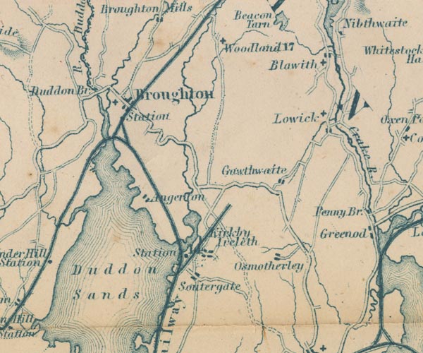 GAR2SD28.jpg
 |
Angerton -- building/s -- SD2184
-- 'Angerton' -- blocks, settlement
Blawith -- building/s -- SD288883 -- 'Blawith' -- blocks, settlement, and a cross, a church Broughton in Furness Station -- railway station -- station -- SD2187 -- 'Station' -- no dot, triangular junction with Coniston Triple line, light bold light, railway shown. Broughton in Furness -- building/s etc -- SD211876 -- 'Broughton' -- blocks, settlement, and a cross, a church church, Blawith -- church -- SD288883 (?) -- cross, a church Coniston Railway -- railway -- triple line, light bold light, railway Duddon Bridge -- bridge -- SD19928818 -- 'Duddon Br.' -- road crosses stream Duddon Sands -- foreshore etc -- SD2081 (etc) -- 'Duddon Sands' -- area in Duddon Estuary Duddon, River -- river -- NY2602 (etc) -- 'R. Duddon' -- wiggly line, river, broadening at its foot; and county boundary Furness Railway -- railway etc -- 'Furness Railway' -- 'Furness Railway' -- triple line, light bold light, railway; note branch at Kirkby Ireleth Gawthwaite -- building/s -- SD271848 -- 'Gawthwaite' -- blocks, settlement Kikrby Ireleth -- 'Kikrby Ireleth' -- blocks, settlement Kirkby Pool -- river -- SD2386 (etc) -- wiggly line, river Kirkby Station -- railway station -- station -- SD22698251 -- 'Sta' -- dot by railway Lickle, River -- river etc -- SD2190 (etc) -- wiggly line, river Lowick -- locality -- building/s -- SD290860 (etc) -- 'Lowick' -- blocks, settlement, and a cross, a church Osmotherley -- locality -- SD2780 -- 'Osmotherley' -- blocks, settlement Soutergate -- building/s -- SD2281 -- 'Soutergate' -- blocks, settlement St John's Church -- church -- SD24728910 -- cross, a church St Luke's Church -- church -- SD28988606 -- cross, a church St Mary's Church -- church -- SD20938737 -- cross, a church Whitehaven and Furness Junction Railway -- railway -- 'Whitehaven & Furness Junction Raily.' -- triple line, light bold light, railway Woodland -- building/s -- SD247890 -- 'Woodland' -- cross, a church | |
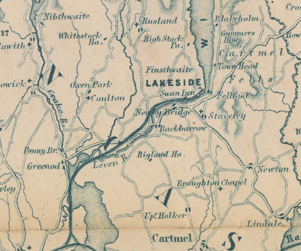 GAR2SD38.jpg
 |
Backbarrow -- building/s -- SD357847
-- 'Backbarrow' -- blocks, settlement
Beck Side -- building/s -- SD373804 -- 'Upr. Holker' -- blocks, settlement just possibly Bigland Hall -- building/s -- SD35458314 -- 'Bigland Ho.' -- block, building Cartmel Fell -- building/s -- locality -- SD415880 (etc) ? -- 'Cartmel Fells' -- area Colton -- building/s -- SD316860 -- 'Coulton' -- cross, a church Crake, River -- river etc -- SD2987 (etc) -- 'Crake R.' -- wiggly line, river Fell Foot -- park -- building/s -- SD3887 (etc) -- 'Fellfoot' -- blocks, settlement Finsthwaite -- building/s -- SD368878 -- 'Finsthwaite' -- no symbol Greenodd -- building/s -- SD313825 -- 'Greenod' -- blocks, settlement Gummer's How -- hill -- SD39048848 -- 'Gummers How' -- hill hachuring High Stott Park -- building/s -- SD372885 ? -- 'High Stock Pa.' -- block, building Holy Trinity Church -- church -- SD31838604 -- cross, a church Lakeside branch railway -- railway -- triple line, light bold light, railway Lakeside -- building/s -- SD378873 -- 'LAKESIDE' -- block, building Leven, River -- river etc -- SD3483 (etc) ? -- 'Leven R.' -- double wiggly line, and estuary Newby Bridge -- bridge -- SD36918636 ? -- 'Newby Bridge' -- road crosses stream Oxen Park -- building/s -- SD320871 -- 'Oxen Park' -- block, building Penny Bridge -- building/s -- SD309828 -- 'Penny Br.' -- block, building Rusland Pool -- river -- SD3487 (etc) -- wiggly line, river Rusland -- building/s -- SD339888 -- 'Rusland' -- blocks, settlement, and a cross, a church St Mary's Church -- church -- SD37928593 -- cross, a church St Paul, Rusland, Colton -- cross, a church St Peter's Church -- church -- SD38718179 -- 'Broughton Chapel' -- cross, a church Staveley-in-Cartmel -- building/s -- SD379861 -- 'Staveley' -- blocks, settlement, and a cross, a church Swan Hotel -- inn -- SD36948637 -- 'Swan Inn' -- block, building Town Head -- building/s -- SD38388772 -- 'Town Head' -- block, building Whitestock Hall -- building/s -- SD329888 -- 'Whitestock Ha.' -- block, building Windermere lake -- lake -- SD392950 ? -- 'WINDER MERE' -- outline with shore form lines, lake or tarn | |
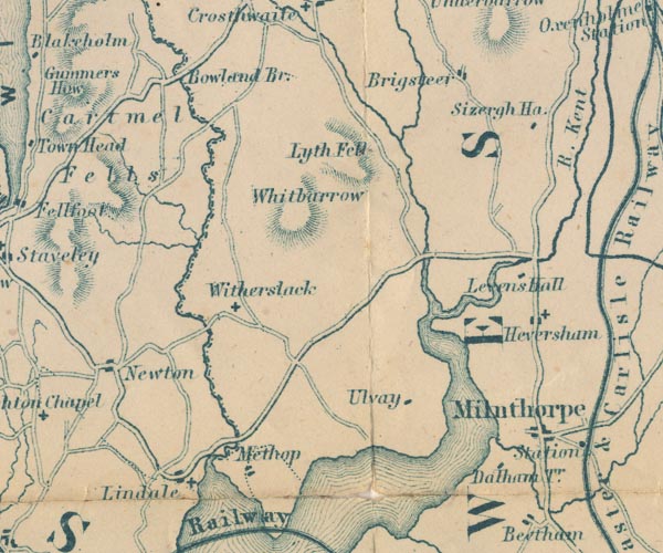 GAR2SD48.jpg
 |
Bowland Bridge -- bridge -- boundary stone --
SD41718955
-- 'Bowland Br.' -- road crosses stream
Brigsteer -- building/s -- SD480895 -- 'Brigsteer' -- blocks, settlement Dallam Tower -- building/s -- park -- SD490810 -- 'Dalham Tr.' -- block, building Gilpin, River -- river etc -- SD4490 (etc) -- wiggly line, river Heversham -- building/s -- SD497833 -- 'Heversham' -- blocks, settlement, and a cross, a church High Newton -- building/s -- SD400828 -- 'Newton' -- blocks, settlement Levens Hall -- building/s -- house -- garden -- SD494850 -- 'Levens Hall' -- block, building Lindale -- building/s -- SD415805 -- 'Lindale' -- blocks, settlement, and a cross, a church Lyth Fell -- hill -- fell -- SD441894 (etc) -- 'Lyth Fell' -- hill hachuring Meathop -- building/s -- SD4380 -- 'Methop' -- blocks, settlement Milnthorpe -- building/s etc -- SD496815 -- 'Milnthorpe' -- blocks, settlement Pool, River -- river -- SD4690 (etc) -- wiggly line, river Lancaster to Kendal -- route -- road etc -- SD46 -- double line, bold light, major road Sizergh Castle -- building/s -- house -- park -- SD493874 -- 'Sizergh Ha.' -- block, building St Paul's Church -- church -- SD41418039 -- cross, a church St Paul's Church -- church -- SD43168418 -- cross, a church St Peter's Church -- church -- SD49598338 -- cross, a church Ulpha -- building/s -- SD452813 -- 'Ulvay' -- block, building presumably Whitbarrow -- hill -- SD4486 (etc) -- 'Whitbarrow' -- hill hachuring Winster, River -- river -- SD4285 (etc) -- wiggly line, river, and county boundary Witherslack -- building/s -- SD4383 -- 'Witherslack' -- cross, a church | |
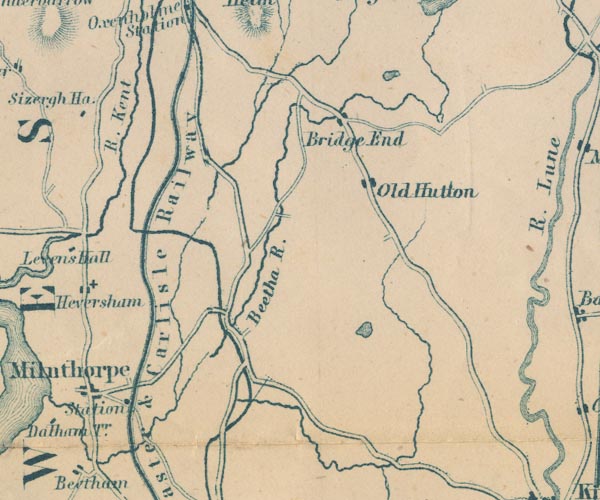 GAR2SD58.jpg
 |
Bela, River -- river -- SD5079 (etc)
-- 'Beetha R.' -- wiggly line, river
Eskrigg Tarn -- lake -- SD576889 -- outline with shore form lines, lake or tarn probably Kent, River -- river etc -- NY4506 (etc) -- 'Kent R.' -- 'R. Kent' -- wiggly line, river Lancaster and Carlisle Railway -- railway -- 'Lancaster & Carlisle Railway' -- 'Lancaster & Carlisle Railway' -- triple line, light bold light, railway Lancaster Canal -- canal etc -- SD58 (etc) -- bold line Lupton Beck -- river -- SD5780 (etc) -- wiggly line, river Middleshaw -- building/s -- SD555891 -- 'Bridge End' -- blocks, settlement possibly Milnthorpe Station -- railway station -- station -- SD5181 -- 'Station' -- dot by railway Old Hutton -- building/s -- SD558886 -- 'Old Hutton' -- blocks, settlement Peasey Beck -- river -- SD5486 (etc) -- wiggly line, river Tarnhouse Tarn -- lake -- SD571833 -- outline with shore form lines, lake or tarn probably | |
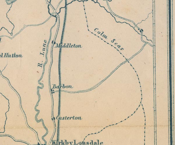 GAR2SD68.jpg
 |
Barbon -- building/s -- SD6282
-- 'Barbon' -- blocks, settlement
Casterton -- building/s -- SD6279 -- 'Casterton' -- blocks, settlement Low Gill and Ingleton branch railway (?) -- railway etc -- triple line, light bold light, railway Lune, River -- river etc -- NY6205 (etc) -- 'R. Lune' -- 'R. Lune' -- 'R. Lune' -- wiggly line, river -- double wiggly line Middleton Fell -- hill -- fell -- SD6586 (etc) -- 'Colm Scar' -- labelled along the county boundary Middleton -- area -- SD6486 (etc) -- 'Middleton' -- blocks, settlement | |
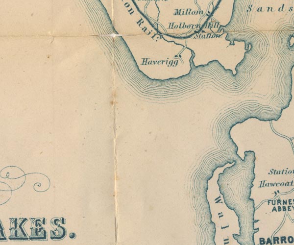 GAR2SD17.jpg
 |
Haverigg -- building/s -- SD158787
-- 'Haverigg' -- blocks, settlement
Holborn Hill -- locality -- SD170803 (etc) -- 'Holborn Hill' -- block, building Millom Station -- railway station -- station -- SD17218019 -- 'Station' -- dot by railway Walney Island -- island -- SD1767 ? -- 'Walney Id.' -- island | |
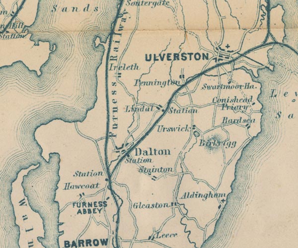 GAR2SD27.jpg
 |
Aldingham -- building/s -- SD2871
-- 'Aldingham' -- blocks, settlement
Bardsea -- building/s -- SD3074 -- 'Bardsea' -- blocks, settlement Birkrigg -- building/s -- SD277745 -- 'Birkrigg' -- hill hachuring Conishead Priory -- building/s -- religious house -- temple -- garden -- SD304757 ? -- 'Conishead Priory' -- block, building Dalton Station -- railway station -- station -- SD23127380 -- 'Station' -- dot by railway Dalton-in-Furness -- building/s etc -- SD227738 -- 'Dalton' -- blocks, settlement Duddon Estuary -- estuary -- river estuary etc -- SD1475 (etc) -- area Dunnerholme -- peninsula -- building/s -- SD212797 -- peninsula in Duddon Estuary Furness Abbey -- abbey -- religious house -- SD218717 -- 'FURNESS ABBEY' -- block, building Furness Railway -- railway etc -- 'Furness Railway' -- 'Furness Railway' -- triple line, light bold light, railway; note branch at Kirkby Ireleth Gleaston -- building/s -- SD255707 -- 'Gleaston' -- blocks, settlement Great Urswick -- building/s -- SD2674 -- 'Urswick' -- blocks, settlement Hawcoat -- building/s -- SD207720 (etc) ? -- 'Hawcoat' -- blocks, settlement Ireleth -- building/s -- SD2177 -- 'Ireleth' -- blocks, settlement Lindal in Furness -- building/s -- SD2475 -- 'Lindal' -- blocks, settlement Lindal Station -- railway station -- station -- SD2575 -- 'Station' -- dot by railway Pennington -- building/s -- SD2677 -- 'Pennington' -- blocks, settlement St Mary and Holy Trinity Church -- church -- SD28887865 -- cross, a church Swarthmoor Hall -- building/s -- house -- museum -- meeting house -- quaker meeting -- SD281772 -- 'Swarthmoor Ha.' -- block, building Ulverston -- building/s etc -- SD289783 -- 'ULVERSTON' -- blocks, settlement, and a cross, a church, on a minimal street plan Ulverstone and Lancaster Railway -- railway etc -- 'Midland Railway' -- triple line, light bold light, railway -- note the triangular juntion with the Lakside branch; the route across Leven Sands is interesting Urswick Tarn -- lake -- SD270744 -- outline with shore form lines, lake or tarn | |
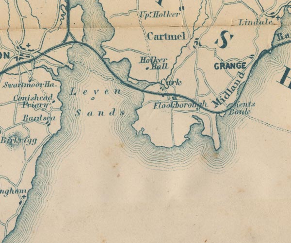 GAR2SD37.jpg
 |
Cark -- building/s -- SD363765
-- 'Cark' -- blocks, settlement
Cartmel -- building/s etc -- SD382786 -- 'Cartmel' -- blocks, settlement Eea, River -- river -- SD3778 (etc) -- wiggly line, river Flookburgh -- building/s -- SD3675 -- 'Flookborough' -- blocks, settlement Holker Hall -- building/s -- house -- park -- garden -- SD359774 -- 'Holker Hall' -- block, building Kent's Bank -- building/s -- SD397762 (etc) -- 'Kents Bank' -- no symbol Leven Estuary -- estuary -- river estuary -- sea area -- SD3375 (etc) -- area sands road, Leven Sands -- sands road -- route -- SD37 -- double dotted line Ulverston Canal -- canal -- SD29397852 & SD31317768 -- bold line Ulverston Sands -- sands -- SD3074 (etc) -- 'Leven Sands' -- area in the estuary Ulverstone and Lancaster Railway -- railway etc -- 'Midland Railway' -- triple line, light bold light, railway -- note the triangular juntion with the Lakside branch; the route across Leven Sands is interesting | |
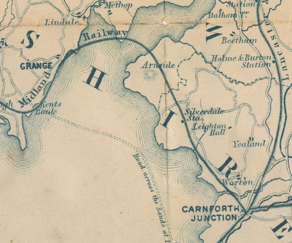 GAR2SD47.jpg
 |
Arnside -- building/s -- SD456787
-- 'Arnside' -- no symbol
Beetham -- building/s -- SD4979 -- 'Beetham' -- blocks, settlement Carnforth Station -- railway station -- station -- SD496707 -- 'CARNFORTH JUNCTION' -- dot by railway Kent Estuary -- estuary -- river estuary -- sea area -- SD4377 (etc) -- area Leighton Beck -- river -- boundary -- county boundary -- SD4977 (etc) -- wiggly line, river, and county boundary Leighton Hall -- building/s -- SD494744 -- 'Leighton Hall' -- block, building sands road, Lancaster Sands -- sands road -- route -- SD47 -- 'Road across the Sands at Low Water' -- double dotted line to Kents Bank -- from Hest Bank Silverdale Station -- railway station -- station -- SD476752 -- 'Silverdale Sta.' -- dot by railway Ulverstone and Lancaster Railway -- railway etc -- 'Midland Railway' -- triple line, light bold light, railway -- note the triangular juntion with the Lakside branch; the route across Leven Sands is interesting Warton -- building/s -- SD5072 -- 'Warton' -- blocks, settlement | |
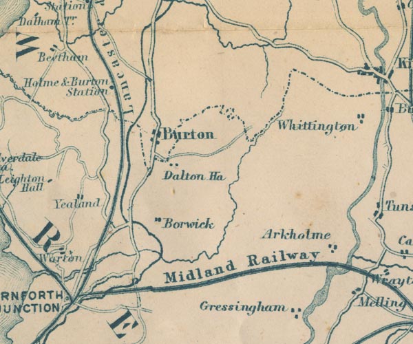 GAR2SD57.jpg
 |
Arkholme -- building/s -- SD583722
-- 'Arkholme' -- blocks, settlement
Borwick -- building/s -- SD5273 -- 'Borwick' -- blocks, settlement Burton and Holme Station -- railway station -- station -- SD52157728 -- 'Holme & Burton Station' -- dot by railway Burton-in-Kendal -- building/s etc -- SD531765 -- 'Burton' -- blocks, settlement Dalton Hall -- building/s -- SD537757 -- 'Dalton Ha.' -- block, building Furness and Midland Joint Railway -- railway -- 'Midland Railway' -- triple line, light bold light, railway Lancaster and Carlisle Railway -- railway -- 'Lancaster & Carlisle Railway' -- 'Lancaster & Carlisle Railway' -- triple line, light bold light, railway Lancaster Canal -- canal etc -- SD58 (etc) -- bold line Lancaster to Kendal -- route -- road etc -- SD46 -- double line, bold light, major road Yealand Conyer -- building/s -- SD5074 -- 'Yealand' -- blocks, settlement possibly Yealand Redmayne -- building/s -- SD502756 -- 'Yealand' -- blocks, settlement possibly | |
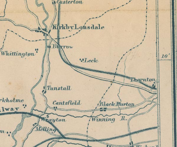 GAR2SD67.jpg
 |
Burton in Lonsdale -- building/s -- SD652722
-- 'Black Burton' -- blocks, settlement
Cantsfield -- building/s -- SD620728 -- 'Cantsfield' -- blocks, settlement Furness and Midland Joint Railway -- railway -- 'Midland Railway' -- triple line, light bold light, railway Greta, River -- river -- SD599728 -- 'Winning R.' -- wiggly line, river Kirkby Lonsdale -- building/s etc -- SD6178 -- 'Kirkby Lonsdale' -- blocks, settlement, on a minimal street plan Leck -- building/s -- SD643767 ? -- 'Leck' -- blocks, settlement Low Gill and Ingleton branch railway (?) -- railway etc -- triple line, light bold light, railway Lune, River -- river etc -- NY6205 (etc) -- 'R. Lune' -- 'R. Lune' -- 'R. Lune' -- wiggly line, river -- double wiggly line Melling -- building/s -- SD598712 -- 'Melling' -- blocks, settlement Over Burrow -- building/s -- SD615758 -- 'Burrow' -- blocks, settlement probably Thornton in Lonsdale -- building/s -- SD685736 -- 'Thornton' -- blocks, settlement Tunstall -- building/s -- SD608735 -- 'Tunstall' -- blocks, settlement Whittington -- building/s -- SD600763 -- 'Whittington' -- blocks, settlement Wrayton -- building/s -- SD611722 -- 'Wrayton' -- blocks, settlement | |
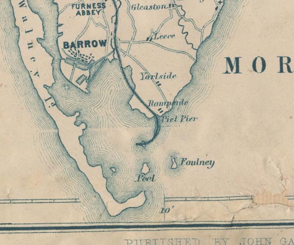 GAR2SD26.jpg
 |
Barrow Docks -- dock -- harbour -- SD2068 (etc)
-- drawn in outline
Barrow Island -- island -- SD2068 -- area Barrow-in-Furness -- building/s etc -- SD198689 -- 'BARROW' -- blocks, settlement Foulney Island -- island -- SD2463 -- 'Foulney' -- island Furness Railway -- railway etc -- 'Furness Railway' -- 'Furness Railway' -- triple line, light bold light, railway; note branch at Kirkby Ireleth Leece -- building/s -- SD2469 -- 'Leece' -- blocks, settlement Piel Channel -- river -- channel -- SD2264 (etc) -- area Piel Island -- island -- SD2363 -- 'Peel' -- island Piel Pier -- pier (gone) -- railway station (? gone) -- SD22766499 (?) & SD23066499 (?) -- 'Piel Pier' -- no symbol; causeway for railway Rampside -- building/s -- SD2466 -- 'Rampside' -- blocks, settlement Roa Island -- island -- SD2364 -- island Walney Channel -- river -- channel -- SD1967 (etc) -- area Yarlside -- building/s -- SD224697 (etc) -- 'Yarlside' -- blocks, settlement | |
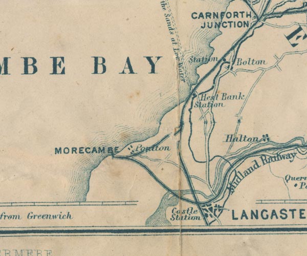 GAR2SD46.jpg
 |
Bolton-le-Sands Station -- railway station (gone) --
SD47986825
-- 'Station' -- dot by railway
Bolton-le-Sands -- building/s etc -- SD4766 -- 'Bolton' -- blocks, settlement Hest Bank Station -- railway station (gone) -- SD47866657 -- 'Hest Bank Station' -- dot by railway Lancaster and Carlisle Railway -- railway -- 'Lancaster & Carlisle Railway' -- 'Lancaster & Carlisle Railway' -- triple line, light bold light, railway Lancaster Canal -- canal etc -- SD58 (etc) -- bold line Lancaster Castle Station -- railway station -- station -- SD472616 -- 'Castle Station' -- no symbol Lune, River -- river etc -- NY6205 (etc) -- 'R. Lune' -- 'R. Lune' -- 'R. Lune' -- wiggly line, river -- double wiggly line Morecambe Bay -- bay -- SD36 (etc) ? -- 'MORECAMBE BAY' -- 'MORECAMBE BAY' -- area Morecambe Harbour and Railway -- railway -- SD46 -- triple line, light bold light, railway North Western Railway -- railway etc -- 'Midland Railway' -- triple line, light bold light, railway Lancaster to Kendal -- route -- road etc -- SD46 -- double line, bold light, major road sands road, Lancaster Sands -- sands road -- route -- SD47 -- 'Road across the Sands at Low Water' -- double dotted line to Kents Bank -- from Hest Bank | |
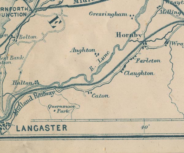 GAR2SD56.jpg
 |
Aughton -- building/s -- SD550672
-- 'Aughton' -- blocks, settlement
Claughton -- building/s -- SD566666 -- 'Claughton' -- blocks, settlement Farleton, Lancsahire -- 'Farleton' -- blocks, settlement Gressingham -- building/s -- SD572699 -- 'Gressingham' -- blocks, settlement Hornby -- building/s -- SD5868 -- 'Hornby' -- blocks, settlement Lune, River -- river etc -- NY6205 (etc) -- 'R. Lune' -- 'R. Lune' -- 'R. Lune' -- wiggly line, river -- double wiggly line North Western Railway -- railway etc -- 'Midland Railway' -- triple line, light bold light, railway Quernmore Park -- locality -- park (once) -- SD516635 (etc) -- 'Quernmoor Park' -- block, building | |
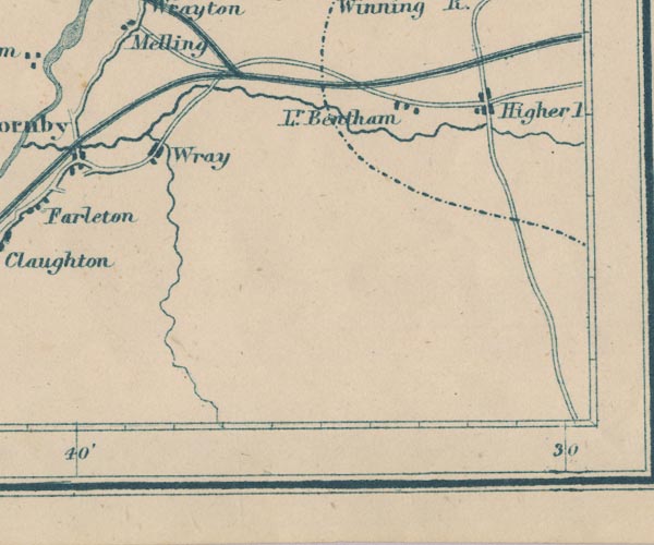 GAR2SD66.jpg
 |
High Bentham -- building/s -- SD667693
-- 'Higher [ ]' -- blocks, settlement
Low Bentham -- building/s -- SD650694 -- 'Lr. Bentham' -- blocks, settlement North Western Railway -- railway etc -- 'Midland Railway' -- triple line, light bold light, railway Wray -- building/s -- SD602676 -- 'Wray' -- blocks, settlement | |
 Lakes Guides menu.