 Ford 1839 map
 |
 |
|
|
Places Identified
Map, uncoloured engraving, Map of the Lake District of Cumberland, Westmoreland and Lancashire, scale about 3.5 miles to 1 inch, published by Charles Thurnham, Carlisle, and by R Groombridge, 5 Paternoster Row, London, 3rd edn 1843. NB: each image includes an overlap, places in the overlap are not listed. The images are roughly equivalent to ngr 10Km squares and are listed from top left to bottom right. | ||
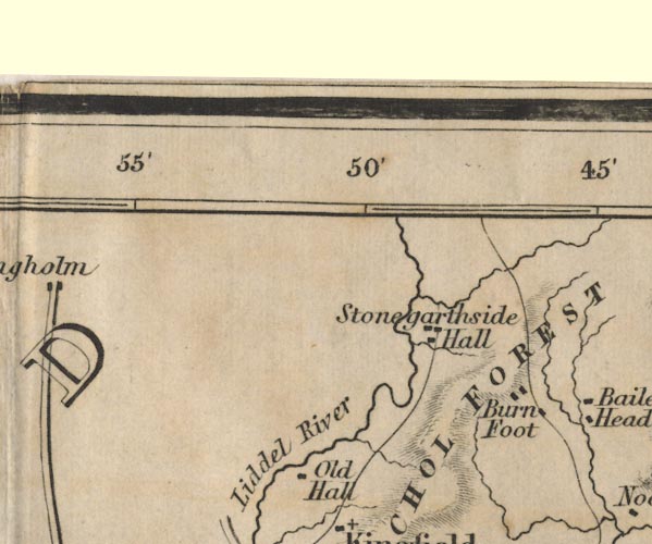 FD02NY48.jpg
 |
Burn Foot
-- 'Burn Foot'
Liddel River -- 'Liddel River' Nichol Forest -- 'NICHOL FOREST' -- Area. Old Hall -- 'Old Hall' Stonegarthside Hall -- 'Stonegarthside Hall' | |
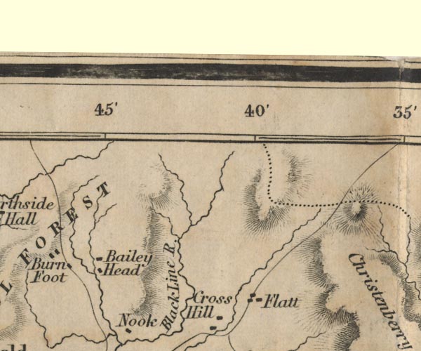 FD02NY58.jpg
 |
Bailey Head
-- 'Bailey Head'
Black Line River -- 'Black Line R.' Cross Hill -- 'Cross Hill' Flatt -- 'Flatt' | |
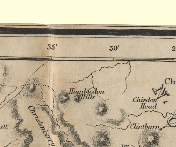 FD02NY68.jpg
 |
Hambledon Hills
-- 'Hambledon Hills'
| |
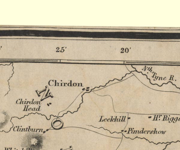 FD02NY78.jpg
 |
Chirdon
-- 'Chirdon'
Chirdon Head -- 'Chirdon Head' Clintburn -- 'Clintburn' Higher Riggs ? -- 'Hr. Riggs' Leekhill -- 'Leekhill' North Tyne River -- 'Nth. Tyne R.' Pimdershow ? -- 'Pimdershow' | |
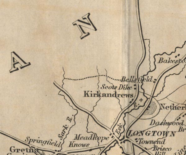 FD02NY37.jpg
 |
Bellsfield
-- 'Bellsfield'
Esk River -- 'Esk R.' Kirkandrews -- 'Kirkandrews' Meadhope -- 'Meadhope' Netherby -- 'Netherby' -- Park and buildings. road, Carlisle to Jedburgh (FD02inc) Sark River -- 'Sark R.' Scots Dike -- 'Scots Dike' -- Building/s. | |
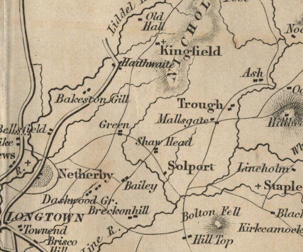 FD02NY47.jpg
 |
Bailey
-- 'Bailey'
Bakeston Gill -- Bakeston Gill -- Settlement or river? Bolton Fell -- 'Bolton Fell' -- Hill hachuring. Breckonhill ? -- 'Breckonhill' Dashwood Green ? -- 'Dashwood Gr.' Green -- 'Green' Haithwaite -- 'Haithwaite' Kingfield -- 'Kingfield' Mallsgate -- 'Mallsgate' Shaw Head -- 'Shaw Head' Solport -- 'Solport' Trough -- 'Trough' | |
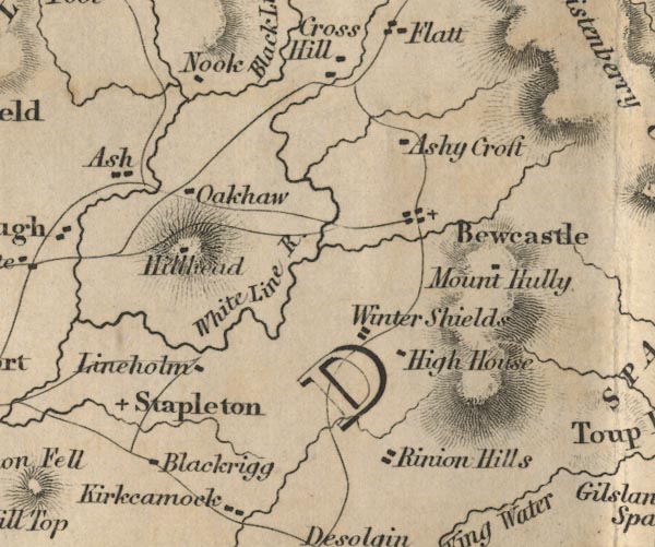 FD02NY57.jpg
 |
Ash
-- 'Ash'
Ashy Croft -- 'Ashy Croft' Bewcastle -- 'Bewcastle' Blackrigg -- 'Blackrigg' High House -- 'High House' Lineholm -- 'Lineholm' Mount Hully -- 'Mount Hully' Nook -- 'Nook' Oakhaw -- 'Oakhaw' Rinion Hills -- 'Rinion Hills' Hillhead ? -- 'Hillhead' -- Building on a hill. Stapleton -- 'Stapleton' White Line River -- 'White Line R.' Winter Shields -- 'Winter Shields' | |
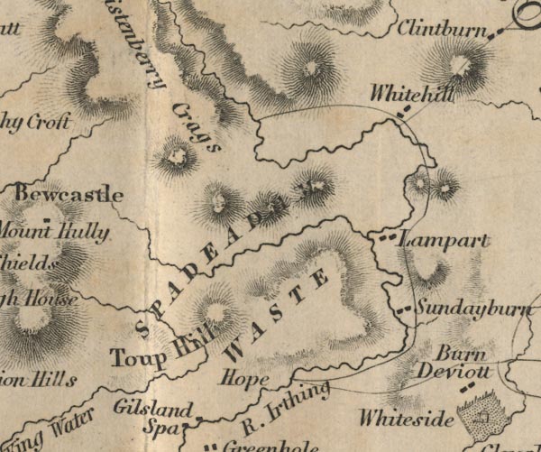 FD02NY67.jpg
 |
Christenberry Crags
-- 'Christenberry Crags' -- Hill hachuring.
Hope -- 'Hope' -- No symbol. Lampart -- 'Lampart' Spadeadam Waste -- 'SPADEADAM WASTE' -- Area. Sundayburn -- 'Sundayburn' Toup Hill ? -- 'Toup Hill' -- Hill hachuring. Whitehill -- 'Whitehill' | |
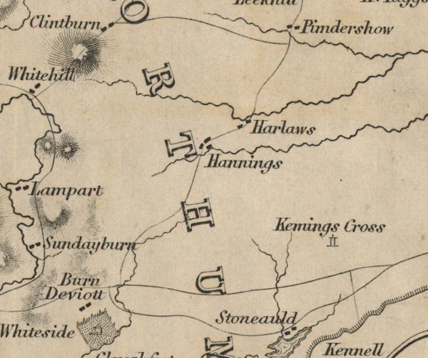 FD02NY77.jpg
 |
Barn Deviott ?
-- 'Barn Deviott'
Kemings Cross ? -- 'Kemings Cross' -- Tower symbol. Hannings -- 'Hannings' Harlaws -- 'Harlaws' | |
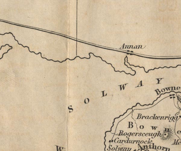 FD02NY16.jpg
 |
Annan
-- 'Annan'
| |
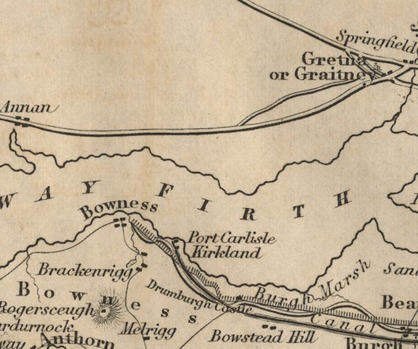 FD02NY26.jpg
 |
Bowness ?
-- 'Bowness' -- Area.
Bowness -- 'Bowness' Brackenrigg -- 'Brackenrigg' Burgh Marsh -- 'Burgh Marsh' -- Area. Carlisle Canal (FD02inc) Drumburgh Castle -- 'Drumburgh Castle' Hadrian's Wall (FD02inc) -- 'Hadrian's Wall' Kirkland -- 'Kirkland' Port Carlisle -- 'Port Carlisle' Rogersceugh -- 'Rogersceugh' Solway Firth -- 'SOLWAY FIRTH' | |
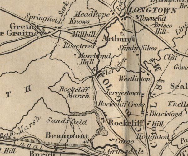 FD02NY36.jpg
 |
Arthuret
-- 'Arthuret'
Beaumont -- 'Beaumont' Blackford -- 'Blackford' Brisco Hill -- 'Brisco Hill' Cargo -- 'Cargo' Floriston ? -- 'Floriston' Gretna -- 'Gretna or Graitney' Hill -- 'Hill' Jerriestown -- 'Jerriestown' Knows -- 'Knows' -- Area? Longtown -- 'Longtown' Millhill -- 'Millhill' Mossband Hall -- 'Mossband Hall' Sandsfield ? -- 'Sandsfield' park, Kingmoor (FD02inc) -- Park near Rockcliff. road, Carlisle to Gretna (FD02inc) -- 'C to G 10 Ms.' road, Carlisle to Jedburgh (FD02inc) road, Carlisle to Langholm (FD02inc) -- 'C to L 8 1/2 Ms.' -- Distance from Carlisle to Longtown. Rockcliff Cross -- 'Rockcliff Cross' Rockcliff Marsh -- 'Rockcliff Marsh' -- Area. Rockcliff -- 'Rockcliff' Rosetrees -- 'Rosetrees' Sandy Sikes -- 'Sandy Sikes' Springfield -- 'Springfield' Townend -- 'Townend' Westlinton -- 'Westlinton' | |
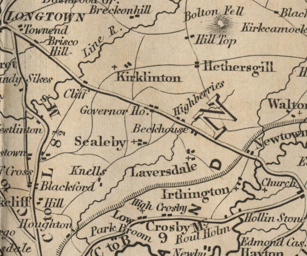 FD02NY46.jpg
 |
Beckhouse
-- 'Beckhouse'
Cliff -- 'Cliff' High Crosby -- 'High Crosby' Hadrian's Wall (FD02inc) Hethersgill -- 'Hethersgill' Highberries -- 'Highberries' Hollin Stone -- 'Hollin Stone' Governor House ? -- 'Governor House' Irthington -- 'Irthington' Kirklinton -- 'Kirklinton' Knells -- 'Knells' Laversdale -- 'Laversdale' Hill Top -- 'Hill Top' Low Crosby -- 'Low Crosby' Line River -- 'Line R.' Newtown -- 'Newtown' road, Brampton to Carlisle (FD02inc) -- 'C to B 9 Ms.' Roul Holm -- 'Roul Holm' Scaleby -- 'Scaleby' | |
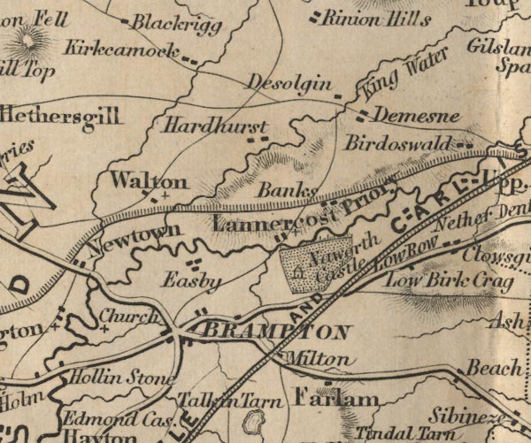 FD02NY56.jpg
 |
Banks
-- 'Banks'
Low Birk Crag ? -- 'Low Birk Crag' -- Hill hachuring. Brampton -- 'Brampton' Desolgin -- 'Desolgin' Farlam -- 'Farlam' Easby ? -- 'Easby' Hadrian's Wall (FD02inc) Hardhurst -- 'Hardhurst' King Water -- 'King Water' Kirkcamock -- 'Kirkcamock' Lannercost Priory -- 'Lannercost Priory' Milton -- 'Milton' Naworth Castle -- 'Naworth Castle' -- Building and park. Newcastle and Carlisle Railway -- 'NEWCASTLE AND CARLISLE RAILWAY' road, Brampton to Carlisle (FD02inc) -- 'C to B 9 Ms.' road, Haltwhistle to Brampton (FD02inc) Demesne ? -- 'Demesne' Walton -- 'Walton' | |
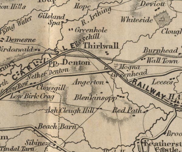 FD02NY66.jpg
 |
Ash Cleugh Hill
-- 'Ash Cleugh Hill'
Birdoswald -- 'Birdoswald' Blenkinsopp -- 'Blenkinsopp' Clowsgill -- 'Clowsgill' Gilsland Spa -- 'Gilsland Spa' Greenhead -- 'Greenhead' Greenhole -- 'Greenhole' Hadrian's Wall (FD02inc) Irthing, River -- 'R. Irthing' Nether Denton -- 'Nether Denton' Angerton -- 'Angerton' Newcastle and Carlisle Railway Red Path -- 'Red Path' Beach Barn -- 'Beach Barn' road, Haltwhistle to Brampton (FD02inc) Mogna -- 'Mogna' -- Symbol for a fort. Rosehill -- 'Rosehill' Thirlwall -- 'Thirlwall' Upper Denton -- 'Upp. Denton' Wall Town -- 'Wall Town' | |
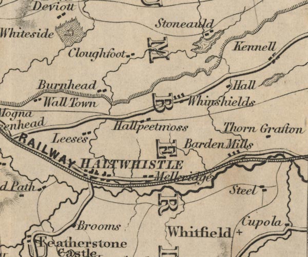 FD02NY76.jpg
 |
Barden Mills
-- 'Barden Mills'
Brooms -- 'Brooms' Broomlee Lough, Northumberland (FD02inc) -- Outline with form lines.. Burnhead -- 'Burnhead' Cloughfoot -- 'Cloughfoot' Greenlee Lough, Northumberland (FD02inc) -- Outline with form lines, near Stoneauld. Hadrian's Wall (FD02inc) Hallpeetmoss -- 'Hallpeetmoss' Haltwhistle -- 'HALTWHISTLE' Leeses -- 'Leeses' Melkridge -- 'Melkridge' Newcastle and Carlisle Railway road, Haltwhistle to Brampton (FD02inc) Stoneauld -- 'Stoneauld' Whiteside -- 'Whiteside' Whinshields -- 'Whinshields' | |
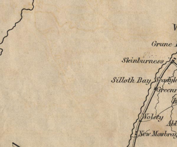 FD02NY05.jpg
 |
Silloth Bay
-- 'Silloth Bay' -- Sea area.
Wolsty -- 'Wolsty' | |
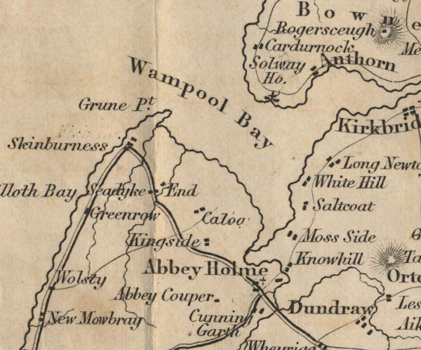 FD02NY15.jpg
 |
Abbey Couper
-- 'Abbey Couper'
Abbey Holme ? -- 'Abbey Holme' Anthorn -- 'Anthorn' Caloo -- 'Caloo' Cardurnock -- 'Cardurnock' Cunning Garth -- 'Cunning Garth' Greenrow -- 'Greenrow' Grune Point -- 'Grune Pt.' Kingside -- 'Kingside' Knowhill -- 'Knowhill' Wampool Bay -- 'Wampool Bay' -- Sea area. Moss Side -- 'Moss Side' Long Newton -- 'Long Newton' Saltcoat -- 'Saltcoat' Seadyke End -- 'Seadyke End' Skinburness -- 'Skinburness' Solway House -- 'Solway Ho.' | |
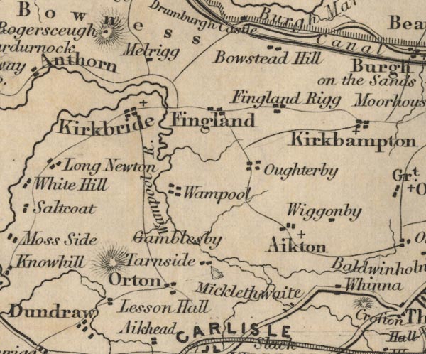 FD02NY25.jpg
 |
Aikton
-- 'Aikton'
Bowstead Hill -- 'Bowstead Hill' Carlisle Canal (FD02inc) Fingland Rigg -- 'Fingland Rigg' Fingland -- 'Fingland' Gamblesby -- 'Gamblesby' Kirkbride -- 'Kirkbride' Lesson Hall -- 'Lesson Hall' Whinna -- 'Whinna' Martin Tarn, Woodside (FD02inc) -- Tarn. Micklethwaite -- 'Micklethwaite' Melrigg -- 'Melrigg' Oughterby -- 'Oughterby' Orton -- 'Orton' Tarnside -- 'Tarnside' Wampool -- 'Wampool' Wampool River -- 'Wampool R.' Wiggonby -- 'Wiggonby' | |
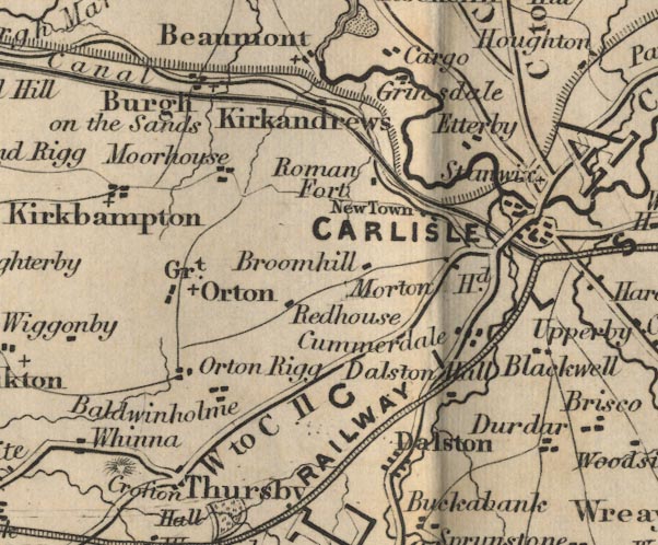 FD02NY35.jpg
 |
Baldwinholme
-- 'Baldwinholme'
Blackwell -- 'Blackwell' Broomhill -- 'Broomhill' Burgh on the Sands -- 'Burgh on the Sands' Carlisle Canal (FD02inc) Carlisle -- 'CARLISLE' Cummerdale -- 'Cummerdale' Dalston Hall -- 'Dalston Hall' Dalston -- 'Dalston' Etterby -- 'Etterby' Great Orton -- 'Grt. Orton' Grinsdale -- 'Grinsdale' Hadrian's Wall (FD02inc) Kirkandrews -- 'Kirkandrews' Kirkbampton -- 'Kirkbampton' Maryport and Carlisle Railway Moorhouse -- 'Moorhouse' Morton Head -- 'Morton Hd.' New Town -- 'New Town' Orton Rigg -- 'Orton Rigg' Redhouse -- 'Redhouse' road, Carlisle to Gretna (FD02inc) -- 'C to G 10 Ms.' road, Carlisle to Jedburgh (FD02inc) road, Carlisle to Langholm (FD02inc) -- 'C to L 8 1/2 Ms.' -- Distance from Carlisle to Longtown. road, Cockermouth to Carlisle (FD02inc) -- 'C to W 16 Ms.' -- 'W to C 11' road, Keswick to Carlisle (FD02inc) -- 'K to C 27 Ms.' -- 'K to C 27 Ms.' roman fort, Newton (FD02inc) -- 'Roman Fort' Stanwix -- 'Stanwix' Thursby -- 'Thursby' | |
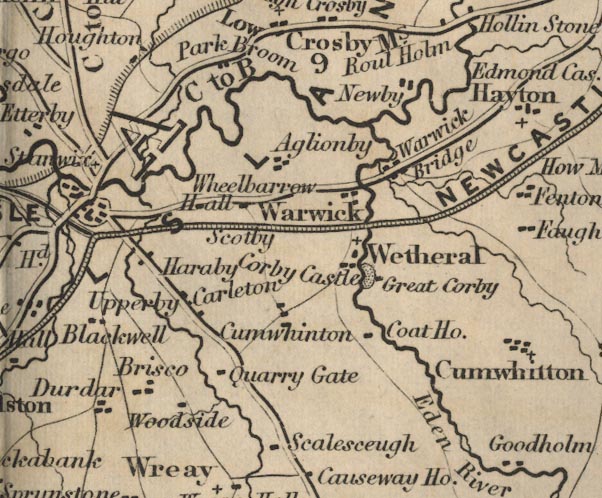 FD02NY45.jpg
 |
Aglionby
-- 'Aglionby'
Brisco -- 'Brisco' Carleton -- 'Carleton' Corby Castle -- 'Corby Castle' -- Building and park. Coat House -- 'Coat Ho.' Cumwhinton -- 'Cumwhinton' Durdar -- 'Durdar' Eden River -- 'Eden R.' Great Corby -- 'Great Corby' Haraby -- 'Haraby' Newby ? -- 'Newby' Newcastle and Carlisle Railway Park Broom -- 'Park Broom' Quarry Gate -- 'Quarry Gate' road, Brampton to Carlisle (FD02inc) -- 'C to B 9 Ms.' road, Carlisle to Alston (FD02inc) -- 'C to A 32 Ms.' road, Penrith to Carlisle (FD02inc) -- 'P to C 18 Ms.' Scalesceugh -- 'Scalesceugh' Scotby -- 'Scotby' Upperby -- 'Upperby' Warwick Bridge -- 'Warwick Bridge' Warwick -- 'Warwick' Wetheral -- 'Wetheral' Wheelbarrow Hall -- 'Wheelbarrow Hall' Woodside -- 'Woodside' | |
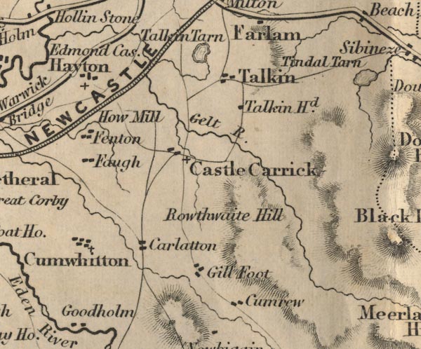 FD02NY55.jpg
 |
Carlatton
-- 'Carlatton'
Castle Carrick -- 'Castle Carrick' Cumrew -- 'Cumrew' Cumwhitton -- 'Cumwhitton' Edmond Castle -- 'Edmond Castle' Faugh -- 'Faugh' Fenton -- 'Fenton' Gelt River -- 'Gelt R.' Gill Foot -- 'Gill Foot' Hayton -- 'Hayton' How Mill -- 'How Mill' Newcastle and Carlisle Railway Rowthwaite Hill ? -- 'Rowthwaite Hill' -- Hill hachuring. Talkin Tarn -- 'Talkin Tarn' -- Outline with form lines. Talkin -- 'Talkin' Talkin Head -- 'Talkin Hd.' | |
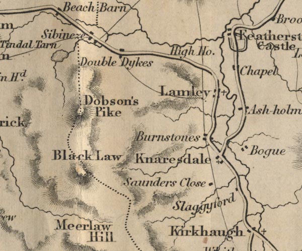 FD02NY65.jpg
 |
Ash Holm
-- 'Ash holm'
Bogue -- 'Bogue' Burnstones -- 'Burnstones' Dobson's Pike ? -- 'Dobson's Pike' -- Hill hachuring, on the county border. Featherstone Castle -- 'Featherstone Castle' -- 'Chapel' -- Buildings and park, to the south is:-. -- The castle had a chapel in the grouunds, to the SE. Black Law -- 'Black Law' -- Hill hachuring, on the county border. High House -- 'High Ho.' Knaresdale -- 'Knaresdale' Lamley -- 'Lamley' Double Dykes -- 'Double Dykes' Saunders Close -- 'Saunders Close' Sibeneze -- 'Sibeneze' Slaggyford -- 'Slaggyford' Tindal Tarn -- 'Tindal Tarn' | |
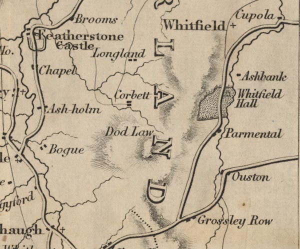 FD02NY75.jpg
 |
Ashbank
-- 'Ashbank'
Corbett -- 'Corbett' Grossley Row -- 'Grossley Row' Dod Law ? -- 'Dod Law' -- Hill hachuring. Longland -- 'Longland' Ouston -- 'Ouston' Parmental -- 'Parmental' Whitfield Hall -- 'Whitfield Hall' -- Building and park. Whitfield -- 'Whitfield' | |
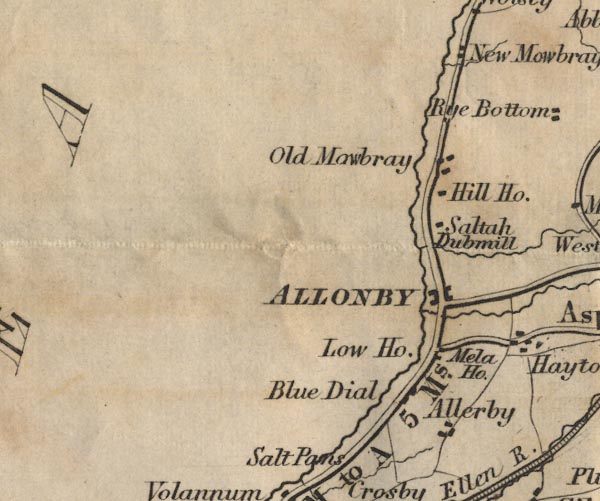 FD02NY04.jpg
 |
Allerby
-- 'Allerby'
Allonby -- 'ALLONBY' Blue Dial -- 'Blue Dial' Dubmill -- 'Dubmill' Low House -- 'Low Ho.' Hill House -- 'Hill Ho.' Old Mawbray ? -- 'Old Mawbray' Mela House -- 'Mela Ho.' New Mawbray -- 'New Mawbray' road, Allonby to Wigton (FD02inc) -- 'A to W 12 Ms.' road, Maryport to Allonby (FD02inc) -- 'M to A 5 Ms.' Saltah -- 'Saltah' | |
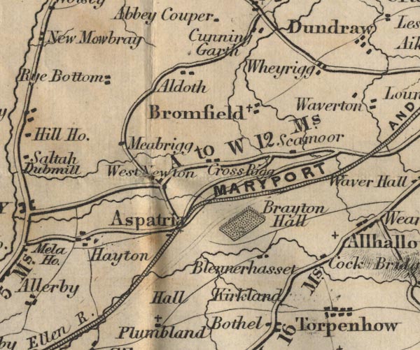 FD02NY14.jpg
 |
Aldoth
-- 'Aldoth'
Arkleby Hall, Plumbland (FD02inc) ? -- 'Hall' -- No symbol. Aspatria -- 'Aspatria' Blennerhasset -- 'Blennerhasset' Brayton Hall -- 'Brayton Hall' -- Park. Bromfield -- 'Bromfield' Cock Bridge -- 'Cock Bridge' -- Building. Cross Rigg -- 'Cross Rigg' Hayton -- 'Hayton' Kirkland ? -- 'Kirkland' Maryport and Carlisle Railway -- 'MARYPORT AND CARLISLE RAILWAY' Meabrigg ? -- 'Meabrigg' road, Allonby to Wigton (FD02inc) -- 'A to W 12 Ms.' road, Cockermouth to Carlisle (FD02inc) -- 'C to W 16 Ms.' -- 'W to C 11' Rye Bottom -- 'Rye Bottom' Scamoor -- 'Scamoor' Torpenhow -- 'Torpenhow' West Newton -- 'West Newton' Wheyrigg -- 'Wheyrigg' | |
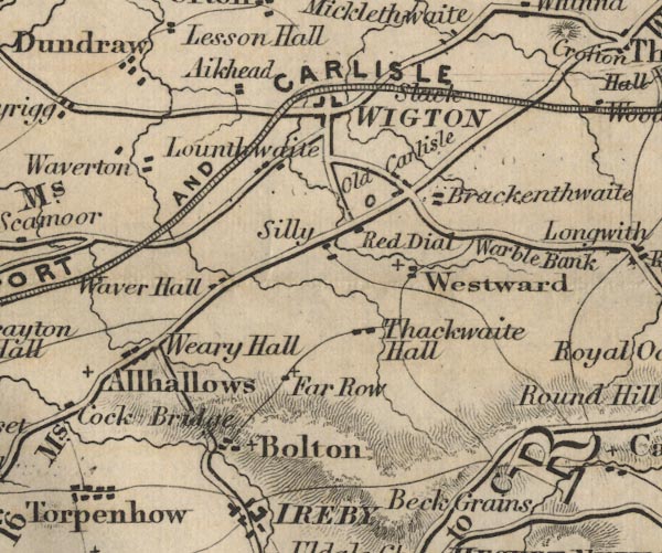 FD02NY24.jpg
 |
Aikhead
-- 'Aikhead'
Allhallows -- 'Allhallows' Bolton -- 'Bolton' Brackenthwaite -- 'Brackenthwaite' Dundraw -- 'Dundraw' Far Row -- 'Far Row' Lounthwaite ? -- 'Lounthwaite' Maryport and Carlisle Railway Old Carlisle -- 'Old Carlisle' Red Dial -- 'Red Dial' road, Allonby to Wigton (FD02inc) -- 'A to W 12 Ms.' road, Cockermouth to Carlisle (FD02inc) -- 'C to W 16 Ms.' -- 'W to C 11' road, Keswick to Wigton (FD02inc) -- 'K to W 22 Ms.' road, Penrith to Wigton (FD02inc) -- 'W to P 21 Ms.' Silly -- 'Silly' Slack -- 'Slack' Thackthwaite Hall -- 'Thackthwaite Hall' Warble Bank -- 'Warble Bank' -- No symbol. Waver Hall ? -- 'Waver Hall' Weary Hall -- 'Weary Hall' Westward -- 'Westward' Wigton -- 'WIGTON' | |
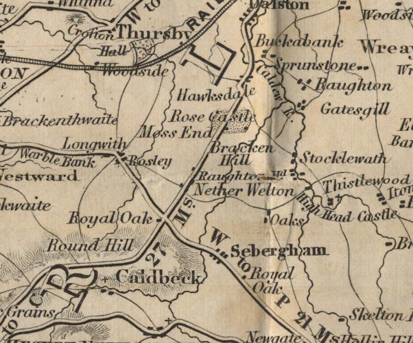 FD02NY34.jpg
 |
Bracken Hill
-- 'Bracken Hill'
Buckabank -- 'Buckabank' Caldbeck -- 'Caldbeck' Calder River -- 'Calder R.' Crofton Hall -- 'Crofton Hall' -- Building and park. Gatesgill -- 'Gatesgill' Hawksdale -- 'Hawksdale' High Head Castle -- 'High Head Ca.' Longwith -- 'Longwith' Maryport and Carlisle Railway Moss End -- 'Moss End' Nether Welton -- 'Nether Welton' Oaks -- 'Oaks' Raughton Head -- 'Raughton Hd.' Raughton -- 'Raughton' road, Keswick to Carlisle (FD02inc) -- 'K to C 27 Ms.' -- 'K to C 27 Ms.' road, Penrith to Wigton (FD02inc) -- 'W to P 21 Ms.' Rose Castle -- 'Rose Castle' -- Building and park. Rosley -- 'Rosley' Round Hill -- 'Round Hill' -- Hill hachuring. Royal Oak -- 'Royal Oak' Royal Oak -- 'Royal Oak' Sebergham -- 'Sebergham' Stocklewath -- 'Stocklewath' Thistlewood -- 'Thistlewood' Woodside -- 'Woodside' | |
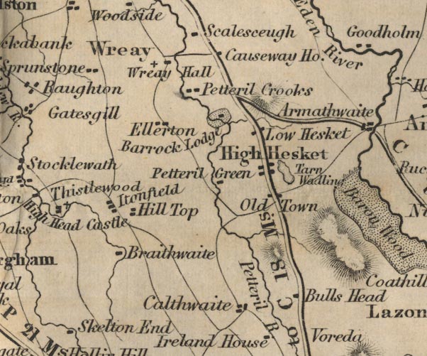 FD02NY44.jpg
 |
Barrock Lodge
-- 'Barrock Lodge' -- Building and park.
Braithwaite ? -- 'Braithwaite' Bulls Head -- 'Bulls Head' Calthwaite -- 'Calthwaite' Causeway House -- 'Causeway Ho.' Ellerton ? -- 'Ellerton' High Hesket -- 'High Hesket' Hill Top -- 'Hill Top' Itonfield -- 'Itonfield' Low Hesket -- 'Low Hesket' Old Town -- 'Old Town' Petteril Crooks -- 'Petteril Crooks' Petteril Green -- 'Petteril Green' Petteril River -- 'Petteril R.' road, Carlisle to Alston (FD02inc) -- 'C to A 32 Ms.' road, Penrith to Carlisle (FD02inc) -- 'P to C 18 Ms.' Sprunstone -- 'Sprunstone' Tarn Wadling -- 'Tarn Wadling' -- Outline with form lines. Wreay Hall -- 'Wreay Hall' Wreay -- 'Wreay' | |
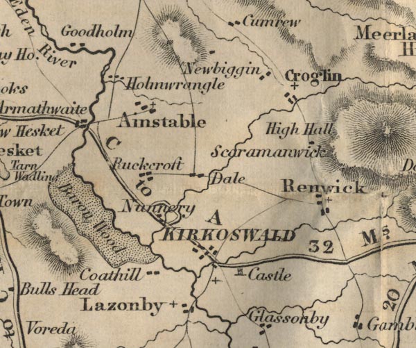 FD02NY54.jpg
 |
Ainstable
-- 'Ainstable'
Armathwaite -- 'Armathwaite' Barou Wood -- 'Barou Wood' -- Shown as a park. Coathill -- 'Coathill' High Hall -- 'High Hall' Croglin -- 'Croglin' Dale ? -- 'Dale' Holmwrangle -- 'Holmwrangle' Kirkoswald Castle, Kirkoswald (FD02inc) -- 'Castle' Kirkoswald -- 'KIRKOSWALD' Lazonby -- 'Lazonby' Goodholm -- 'Goodholm' Newbiggin -- 'Newbiggin' Nunnery -- 'Nunnery' Renwick -- 'Renwick' road, Carlisle to Alston (FD02inc) -- 'C to A 32 Ms.' Puckcroft -- 'Puckcroft' Scaramanwick -- 'Scaramanwick' | |
 FD02NY64.jpg
 |
Ameshaugh
-- 'Ameshaugh'
Meerlaw Hill ? -- 'Meerlaw Hill' -- Hill hachuring. Daffenside Beacon -- 'Daffenside Beacon' -- Tower symbol. Hartside Cross -- 'Hartside Cross' -- Cross symbol. Kirkhaugh -- 'Kirkhaugh' road, Carlisle to Alston (FD02inc) -- 'C to A 32 Ms.' road, Penrith to Alston (FD02inc) -- 'P to A 20 Ms.' Shaw House -- 'Shaw Ho.' Thackmoor Fell ? -- 'Thackmoor Fell' -- Hill hachuring. Whitley -- 'Whitley' -- Symbol for a ? | |
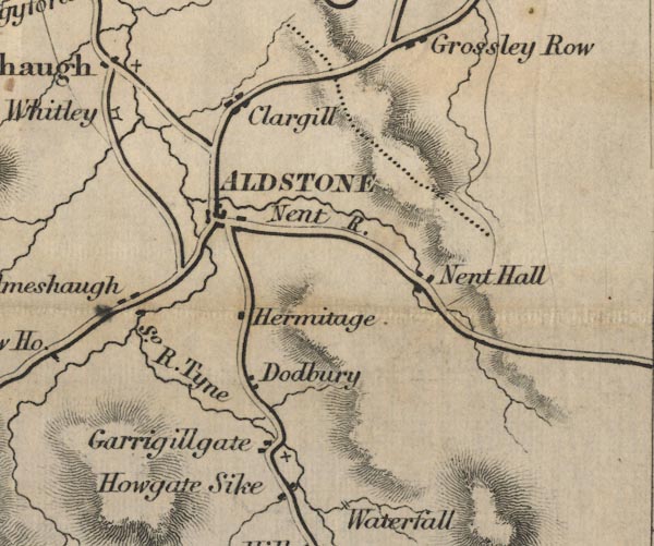 FD02NY74.jpg
 |
Aldstone
-- 'Aldstone'
Clargill -- 'Clargill' Dodbury -- 'Dodbury' Garrigillgate -- 'Garrigillgate' Hermitage -- 'Hermitage' Howgate Sike -- 'Howgate Sike' Nent Hall -- 'Nent Hall' road, Carlisle to Alston (FD02inc) -- 'C to A 32 Ms.' road, Penrith to Alston (FD02inc) -- 'P to A 20 Ms.' South River Tyne -- 'So. R. Tyne' | |
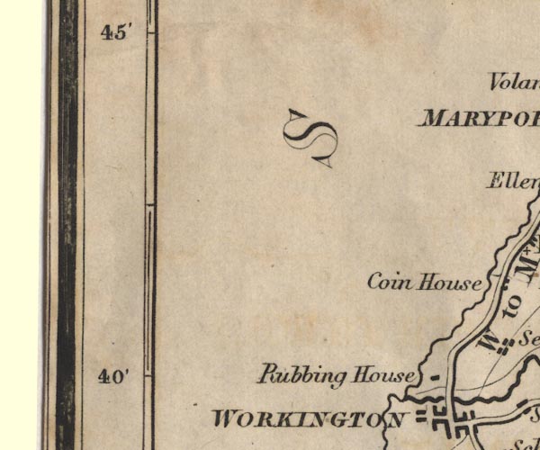 FD02NX93.jpg
 |
Irish Sea
-- 'IRISH SEA'
Rubbing House -- 'Rubbing House' | |
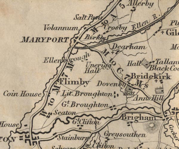 FD02NY03.jpg
 |
Birkby
-- 'Birkby'
Brigham -- 'Brigham' Coin House -- 'Coin House' Crosby -- 'Crosby' Dearham -- 'Dearham' Dovenby Hall, Dovenby (FD02inc) -- 'Hall' -- Building and park. Dovenby -- 'Dovenby' Ellen River -- 'Ellen R.' Ellenborough -- 'Ellenborough' Unerigg Hall -- 'Unerigg Hall' Flimby -- 'Flimby' Great Broughton -- 'Gt. Broughton' Great Clifton -- 'Gt. Clifton' hall, Tallentire (FD02inc) -- 'Hall' -- Building and park, near Tallentire. Little Broughton -- 'Lit. Broughton' Maryport and Carlisle Railway Maryport -- 'MARYPORT' road, Cockermouth to Maryport (FD02inc) -- 'M to C 7 1/2 Ms.' road, Cockermouth to Whitehaven (FD02inc) -- 'W to C 14 Ms.' road, Maryport to Allonby (FD02inc) -- 'M to A 5 Ms.' road, Workington to Maryport (FD02inc) -- 'W to M 7 Ms.' Volannum ? -- 'Volannum' salt pans, Crosscanonby (FD02inc) -- 'Salt Pans' Seaton -- 'Seaton' | |
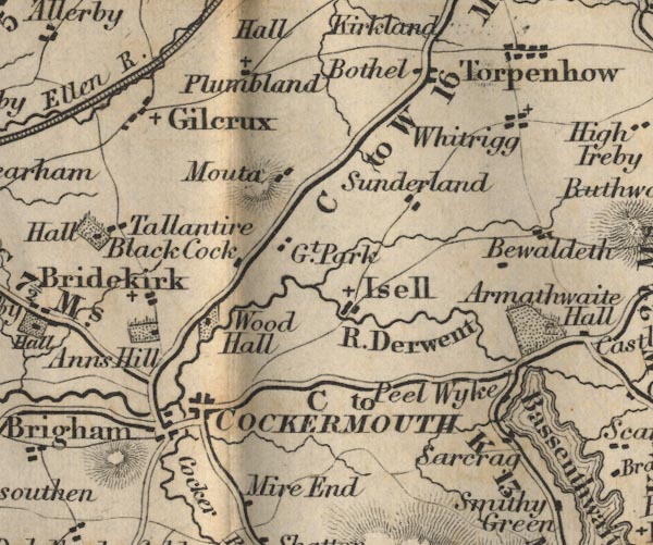 FD02NY13.jpg
 |
Anns Hill
-- 'Anns Hill' -- Building and park.
Bewaldeth -- 'Bewaldeth' Black Cock -- 'Black Cock' Bothel -- 'Bothel' Bridekirk -- 'Bridekirk' Cockermouth -- 'COCKERMOUTH' Derwent, River -- 'R. Derwent' Peel Wyke -- 'Peel Wyke' Gilcrux -- 'Gilcrux' Great Park ? -- 'Gt. Park' Isell -- 'Isell' Mouta -- 'Mouta' Sarcrag -- 'Sarcrag' Plumbland -- 'Plumbland' road, Cockermouth to Carlisle (FD02inc) -- 'C to W 16 Ms.' -- 'W to C 11' road, Cockermouth to Maryport (FD02inc) -- 'M to C 7 1/2 Ms.' road, Cockermouth to Whitehaven (FD02inc) -- 'W to C 14 Ms.' road, Keswick to Cockermouth (FD02inc) -- 'C to K 12 Ms.' -- 'C to K 13 Ms.' -- Two routes shown, by Bassenthwaite and over Whinlatter Pass. Sunderland -- 'Sunderland' Tallentire -- 'Tallentire' Whitrigg -- 'Whitrigg' Wood Hall -- 'Wood Hall' -- Building and park. | |
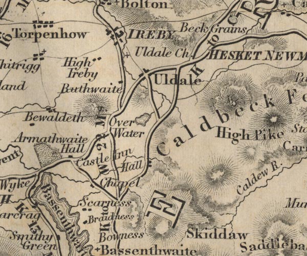 FD02NY23.jpg
 |
Armathwaite Hall
-- 'Armathwaite Hall' -- Building and park.
Bassenthwaite Water -- 'Bassenthwaite Wr.' -- Outline with form lines. Beck Grains -- 'Beck Grains' Bradness -- 'Bradness' Caldbeck Fells -- 'Caldbeck Fells' -- Hill hachuring. Castle Inn ? -- 'Castle Inn' chapel, Bassenthwaite (FD02inc) -- 'Chapel' High Ireby -- 'High Ireby' Ireby -- 'IREBY' Orthwaite Hall, Ireby (FD02inc) ? -- 'Hall' Over Water -- 'Over Water' -- Outline with form lines. road, Keswick to Carlisle (FD02inc) -- 'K to C 27 Ms.' -- 'K to C 27 Ms.' road, Keswick to Wigton (FD02inc) -- 'K to W 22 Ms.' Buthwaite -- 'Buthwaite' Scarness -- 'Scarness' Skiddaw -- 'Skiddaw' -- Hill hachuring. Uldale Chapel -- 'Uldale Ch.' | |
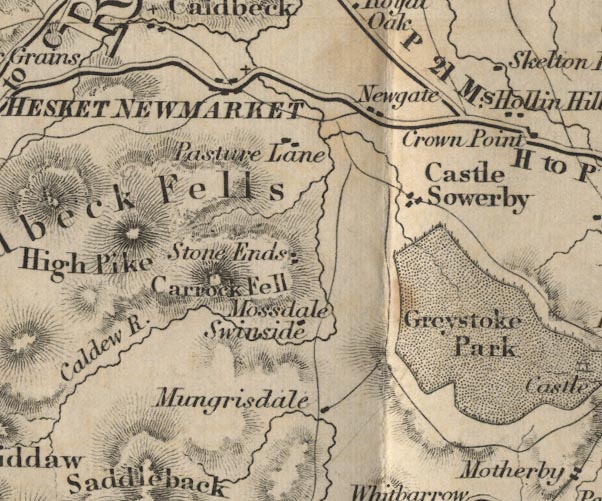 FD02NY33.jpg
 |
Caldbeck Fells
-- 'Caldbeck Fells' -- Hill hachuring.
Caldew River -- 'Caldew R.' Carrock Fell -- 'Carrock Fell' -- Hill hachuring. Castle Sowerby -- 'Castle Sowerby' Greystoke Park -- 'Greystoke Park' Hesket Newmarket -- 'HESKET NEWMARKET' High Pike -- 'High Pike' -- Hill hachuring. Mossdale -- 'Mossdale' Mungrisdale -- 'Mungrisdale' Newgate -- 'Newgate' Pasture Lane -- 'Pasture Lane' road, Penrith to Hesket Newmarket (FD02inc) -- 'H to P 13 Ms.' road, Penrith to Wigton (FD02inc) -- 'W to P 21 Ms.' Skelton End ? -- 'Skelton End' Stone Ends -- 'Stone Ends' Swinside -- 'Swinside' | |
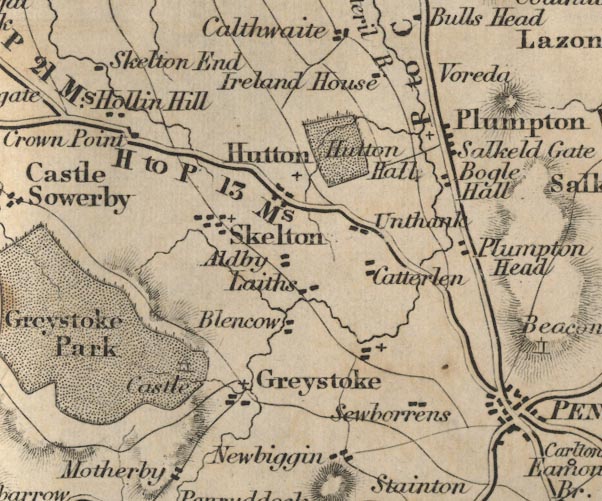 FD02NY43.jpg
 |
Aldby
-- 'Aldby'
Blencow -- 'Blencow' Bogle Hall -- 'Bogle Hall' Ireland House ? -- 'Ireland House' Catterlen -- 'Catterlen' Crown Point -- 'Crown Point' Greystoke Park -- 'Castle' -- In Greystoke Park. Greystoke -- 'Greystoke' Hollin Hill -- 'Hollin Hill' Hutton ? -- 'Hutton' Hutton Hall -- 'Hutton Hall' -- Building and park. Laiths -- 'Laiths' Plumpton Head -- 'Plumpton Head' Plumpton Wall -- 'Plumpton Wall' Salkeld Gate -- 'Salkeld Gate' road, Penrith to Carlisle (FD02inc) -- 'P to C 18 Ms.' road, Penrith to Hesket Newmarket (FD02inc) -- 'H to P 13 Ms.' road, Penrith to Wigton (FD02inc) -- 'W to P 21 Ms.' Voreda -- 'Voreda' Sewborrens -- 'Sewborrens' Skelton -- 'Skelton' Unthank -- 'Unthank' | |
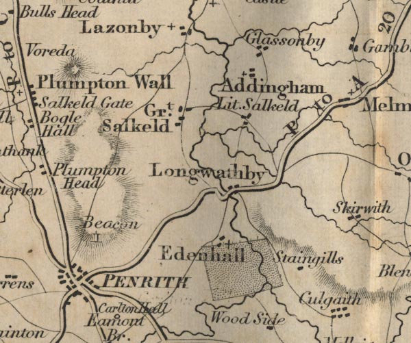 FD02NY53.jpg
 |
Addingham
-- 'Addingham'
Edenhall -- 'Edenhall' Glassonby -- 'Glassonby' Great Salkeld -- 'Gt. Salkeld' Longwathby -- 'Longwathby' Little Salkeld -- 'Lit. Salkeld' Penrith Beacon, Penrith (FD02inc) -- 'Beacon' -- Tower, on the hill N of Penrith. Penrith -- 'PENRITH' road, Penrith to Alston (FD02inc) -- 'P to A 20 Ms.' road, Penrith to Appleby (FD02inc) -- 'P to B 20 Ms.' -- Distance to Brough. road, Penrith to Keswick (FD02inc) -- 'K to P 18 Ms.' road, Penrith to Wigton (FD02inc) -- 'W to P 21 Ms.' road, Shap to Penrith (FD02inc) -- 'S to P 11 Ms.' Staingills -- 'Staingills' | |
 FD02NY63.jpg
 |
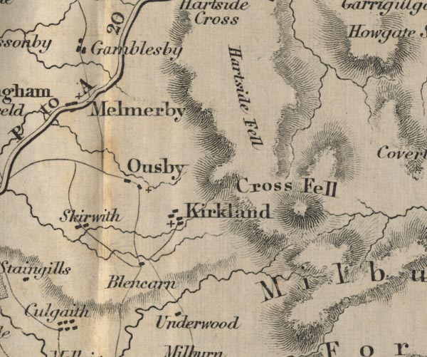
Blencarn
-- 'Blencarn'
Cross Fell -- 'Cross Fell' -- Hill hachuring. Gamblesby -- 'Gamblesby' Kirkland -- 'Kirkland' Hartside Fell -- 'Hartside Fell' -- Hill hachuring. Melmerby -- 'Melmerby' Ousby -- 'Ousby' road, Penrith to Alston (FD02inc) -- 'P to A 20 Ms.' Skirwith -- 'Skirwith' Underwood -- 'Underwood' | |
 FD02NY73.jpg
 |
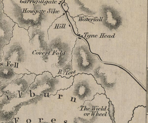
Ashgill Force, Alston Moor (FD02inc)
-- 'Waterfall' -- 2 lines across stream.
Covert Fold -- 'Covert Fold' -- Hill hachuring. Wield, The ? -- 'The Wield or Wheel' -- Outline with form lines / hill hachuring ? Hill -- 'Hill' Milburn Forest -- 'Milburn Forest' -- Area. Tees, River -- 'R. Tees' Tyne Head -- 'Tyne Head' | |
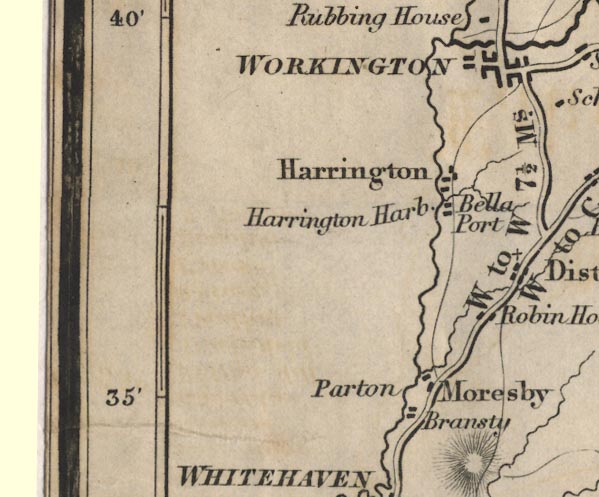 FD02NX92.jpg
 |
Bransty
-- 'Bransty'
Bella Port -- 'Bella Port' -- 'Harrington Harb.' Harrington -- 'Harrington' Moresby -- 'Moresby' Parton -- 'Parton' road, Cockermouth to Whitehaven (FD02inc) -- 'W to C 14 Ms.' road, Whitehaven to Workington (FD02inc) -- 'W to W 7 1/2 Ms.' road, Workington to Maryport (FD02inc) -- 'W to M 7 Ms.' Robin Hood -- 'Robin Hood' Workington -- 'WORKINGTON' | |
 FD02NY02.jpg
 |
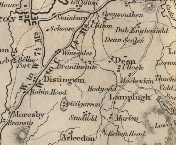
Branthwaite
-- 'Branthwaite'
Dean -- 'Dean' Dean Scales -- 'Dean Scales' Distington -- 'Distington' Dub -- 'Dub' Englesfield -- 'Englesfield' Gilgarron -- 'Gilgarron' -- Buildings and park. Greysouthen -- 'Greysouthen' Hodyoad -- 'Hodyoad' Lamplugh -- 'Lamplugh' Clifton -- 'Clifton' Mockerkin -- 'Mockerkin' Murton -- 'Murton' road, Cockermouth to Whitehaven (FD02inc) -- 'W to C 14 Ms.' road, Whitehaven to Workington (FD02inc) -- 'W to W 7 1/2 Ms.' Schoose -- 'Schoose' Stainbury -- 'Stainbury' Studfold -- 'Studfold' Ullock -- 'Ullock' Winscales -- 'Winscales' | |
 FD02NY12.jpg
 |
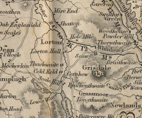
Brackenthwaite
-- 'Brackenthwaite'
Calder River -- 'Calder R.' Causey Pike -- 'Causey Pike' -- Hill hachuring. Cold Keld -- 'Cold Keld' Cornhow -- 'Cornhow' Grassmoor -- 'Grassmoor' -- Hill hachuring. Grisdale Pike -- 'Grisdale Pike' -- Hill hachuring. Lorton ? -- 'Lorton' Hole Mile -- 'Hole Mile' Mire End -- 'Mire End' Longthwaite -- 'Longthwaite' Lorton Hall -- 'Lorton Hall' Lowes Water -- 'Lowes Wr.' -- Outline with form lines. Lowes Water -- 'Lowes Water' Powder Hill ? -- 'Powder Hill' -- Hill hachuring. road, Keswick to Cockermouth (FD02inc) -- 'C to K 12 Ms.' -- 'C to K 13 Ms.' -- Two routes shown, by Bassenthwaite and over Whinlatter Pass. Scale Hill -- 'Scale Hill' Scawgill -- 'Scawgill' Shatton ? -- 'Shatton' Thackthwaite -- 'Thackthwaite' Whinlatter -- 'Whinlatter' -- Pass, hill hachuring. | |
 FD02NY22.jpg
 |
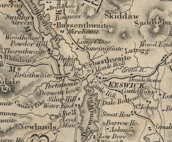
Barrow House
-- 'Barrow Ho.'
Bassenthwaite Water -- 'Bassenthwaite Wr.' -- Outline with from lines. Bowness ? -- 'Bowness' Scoat How -- 'Scoat How' Braithwaite -- 'Braithwaite' Brandlehow Mine, Above Derwent (FD02inc) ? -- 'Lead Mine' Druid Stones -- 'Druid Stones' Castle Hill ? -- 'Castle Hill' -- 'Castle Rigg' Cat Bell -- 'Cat Bell' -- No hachures. Dale Bottom -- 'Dale Bottom' Dancing Gate -- 'Dancing Gate' Water End -- 'Water End' Derwent Lodge -- 'Derwent Lo.' Derwent Water -- 'Derwent Water' -- Outline with form lines. Crossthwaite -- 'Crossthwaite' Greta River -- 'Greta R.' Jenkin Hill -- 'Jenkin Hill' Keswick -- 'KESWICK' Latrigg -- 'Latrigg' -- No hachures. Long Close -- 'Long Close' Mirehouse -- 'Mirehouse' Monk Hall -- 'Monk Hall' Portinscale -- 'Portinscale' Pow House -- 'Pow Ho.' road, Ambleside to Keswick (FD02inc) -- 'K to A 17 Ms.' road, Keswick to Carlisle (FD02inc) -- 'K to C 27 Ms.' -- 'K to C 27 Ms.' road, Keswick to Cockermouth (FD02inc) -- 'C to K 12 Ms.' -- 'C to K 13 Ms.' -- Two routes shown, by Bassenthwaite and over Whinlatter Pass. road, Keswick to Wigton (FD02inc) -- 'K to W 22 Ms.' road, Penrith to Keswick (FD02inc) -- 'K to P 18 Ms.' Silver Hill -- 'Silver Hill' Smithy Green -- 'Smithy Green' Bassenthwaite -- 'Bassenthwaite' -- Labelling the church by the lake. Thornthwaite -- 'Thornthwaite' Woodhouse -- 'Woodhouse' | |
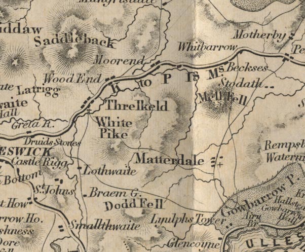 FD02NY32.jpg
 |
Beckses
-- 'Beckses'
Braem Green (?) -- 'Braem G.' Dodd Fell -- 'Dodd Fell' -- Hill hachuring. Mell Fell -- 'Mell Fell' -- Hill hachuring. Moorend -- 'Moorend' Lothwaite -- 'Lothwaite' Lyulph's Tower -- 'Lyulph's Tower' Matterdale -- 'Matterdale' road, Penrith to Keswick (FD02inc) -- 'K to P 18 Ms.' Saddleback -- 'Saddleback' -- Hill hachuring. Smallthwaite -- 'Smallthwaite' St John's -- 'St. John's' -- Labelling buildings. Threlkeld -- 'Threlkeld' Whitbarrow -- 'Whitbarrow' -- Hill hachuring. White Pike -- 'White Pike' -- Hill hachuring. Wood End -- 'Wood End' | |
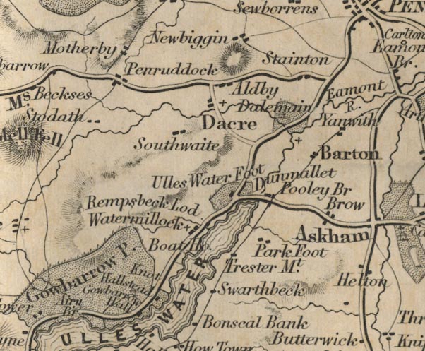 FD02NY42.jpg
 |
Airy Bridge
-- 'Airy Br' -- Road crosses stream.
Aldby -- 'Aldby' Barton -- 'Barton' boat house, Martindale (FD02inc) ? -- 'Boat Ho.' -- Near Watermillock. Trester Mount (?) ? -- 'Trester Mt.' Dacre -- 'Dacre' Dalemain -- 'Dalemain' -- Building and park. Dunmallet -- 'Dunmallet' -- No symbol. Eamont River -- 'Eamont R.' Gowbarrow Hall -- 'Gowbarrow Hall' -- Building; park labelled as well. Gowbarrow Park -- 'Gowbarrow Park' -- Park; also building, labelled separately. Hallstead -- 'Hallstead' Brow ? -- 'Brow' Knot -- 'Knot' Brow ? -- 'Brow' Motherby -- 'Motherby' Newbiggin -- 'Newbiggin' Park Foot -- 'Park Foot' Penruddock -- 'Penruddock' Pooley Bridge -- 'Pooley Bridge' Rampsbeck Lodge -- 'Rampsbeck Lod.' road, Patterdale to Penrith (FD02inc) road, Penrith to Keswick (FD02inc) -- 'K to P 18 Ms.' Southwaite -- 'Southwaite' Stainton -- 'Stainton' Stoddah -- 'Stoddah' Swarthbeck -- 'Swarthbeck' Ulles Water -- 'ULLES WATER' -- Outline with form lines. -- 'ULLES WATER' -- Outline with form lines. Ulles Water Foot -- 'Ulles Water Foot' -- Building and park. Watermillock -- 'Watermillock' Yanwath -- 'Yanwath' | |
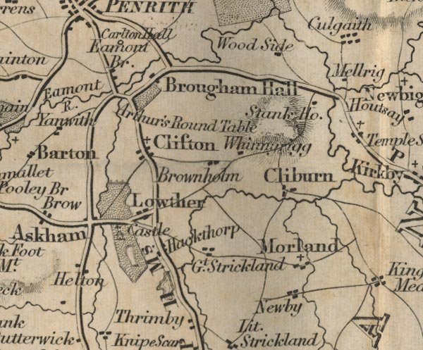 FD02NY52.jpg
 |
Arthur's Round Table
-- 'Arthur's Round Table'
Stank House ? -- 'Stank Ho.' Askham -- 'Askham' Brownholm -- 'Brownholm' Cliburn -- 'Cliburn' Clifton -- 'Clifton' Culgaith -- 'Culgaith' Eamont Bridge -- 'Eamont Br.' Great Strickland -- 'Gt. Strickland' Hackthorp -- 'Hackthorp' Helton -- 'Helton' Lowther Castle, Lowther (FD02inc) -- 'Castle' -- Building and park. Lowther -- 'Lowther' Mellrig -- 'Mellrig' Morland -- 'Morland' Newby -- 'Newby' road, Penrith to Appleby (FD02inc) -- 'P to B 20 Ms.' -- Distance to Brough. road, Shap to Penrith (FD02inc) -- 'S to P 11 Ms.' Whinnarigg -- 'Whinnarigg' Wood Side -- 'Wood Side' | |
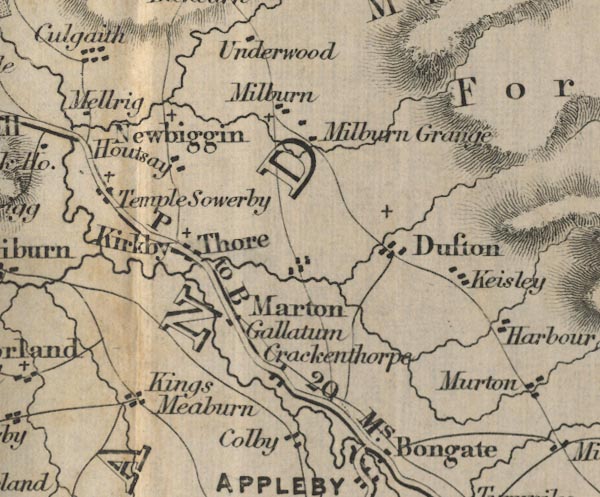 FD02NY62.jpg
 |
Colby
-- 'Colby'
Crackenthorpe -- 'Crackenthorpe' Dufton -- 'Dufton' Houtsay -- 'Houtsay' Keisley -- 'Keisley' Kings Meaburn -- 'Kings Meaburn' Kirkby Thore -- 'Kirkby Thore' Marton -- 'Marton' Milburn Grange -- 'Milburn Grange' Milburn -- 'Milburn' Newbiggin -- 'Newbiggin' road, Penrith to Appleby (FD02inc) -- 'P to B 20 Ms.' -- Distance to Brough. Gallatum -- 'Gallatum' Temple Sowerby -- 'Temple Sowerby' | |
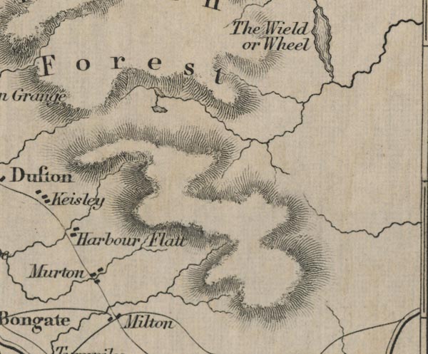 FD02NY72.jpg
 |
Harbour Flat
-- 'Harbour Flat'
Milton -- 'Milton' Milburn Forest -- 'Milburn Forest' -- Area. Murton -- 'Murton' | |
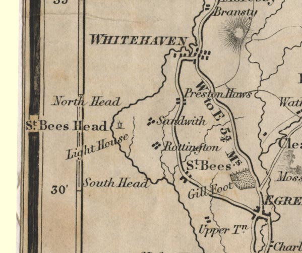 FD02NX91.jpg
 |
Upper Town
-- 'Upper Tn.'
Gill Foot ? -- 'Gill Foot' -- Building and park. North Head -- 'North Head' -- Headland. Preston Haws -- 'Preston Haws' road, Cockermouth to Whitehaven (FD02inc) -- 'W to C 14 Ms.' road, Egremont to Whitehaven (FD02inc) -- 'W to E 5 3/4 Ms.' road, Whitehaven to Workington (FD02inc) -- 'W to W 7 1/2 Ms.' Rottington -- 'Rottington' Sandwith -- 'Sandwith' South Head -- 'South Head' -- Headland. St Bees Head -- 'St. Bees Head' -- Headland. St Bees Lighthouse, St Bees Head (FD02inc) -- 'Light House' -- Tower symbol, on St Bees Head. St Bees -- 'St. Bees' Whitehaven -- 'WHITEHAVEN' | |
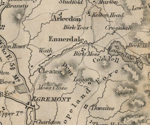 FD02NY01.jpg
 |
Arlecdon
-- 'Arlecdon'
Cleator -- 'Cleator' Cold Fell -- 'Cold Fell' -- Hill hachuring. Copeland Forest -- 'Copeland Forest' -- Area. Crossdale -- 'Crossdale' Dent -- 'Dent' -- Hill hachuring. Egremont -- 'EGREMONT' Ennerdale -- 'Ennerdale' Ennerdale Water -- 'Ennerdale Wr.' -- Outline with form lines. Kellon Head -- 'Kellon Head' Lagget -- 'Lagget' Moss Close -- 'Moss Close' road, Egremont to Ravenglass (FD02inc) -- 'E to R 13 Ms.' Birk Toes -- 'Birk Toes' Thwaites -- 'Thwaites' Wath -- 'Wath' | |
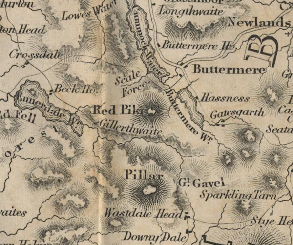 FD02NY11.jpg
 |
Beck House
-- 'Beck Ho.'
Buttermere House ? -- 'Buttermere Ho.' Buttermere Water -- 'Buttermere Wr.' -- Outline with form lines. Buttermere -- 'Buttermere' Crummock Water -- 'Crummock Water' -- Outline with form lines. Ennerdale Water -- 'Ennerdale Wr.' -- Outline with form lines. Gatesgarth -- 'Gatesgarth' Gillerthwaite -- 'Gillerthwaite' Great Gavel -- 'Gt. Gavel' -- Hill hachuring. Hassness -- 'Hassness' Pillar -- 'Pillar' -- Hill hachuring. Red Pike -- 'Red Pike' -- Hill hachuring. Scale Force -- 'Scale Force' Wastdale Head -- 'Wastdale Head' | |
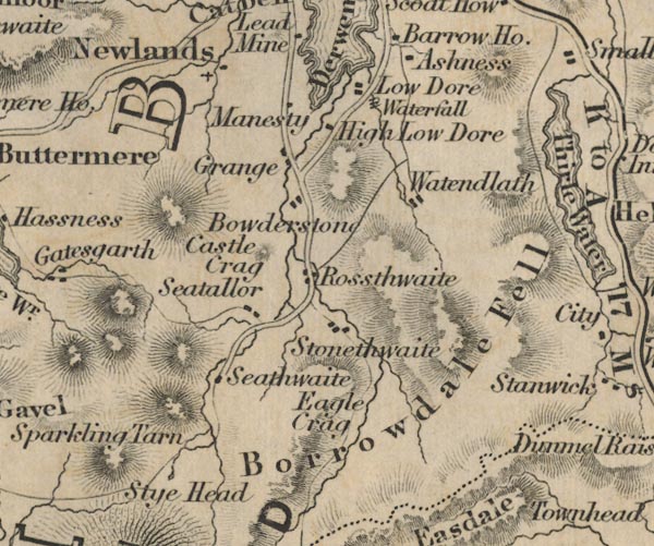 FD02NY21.jpg
 |
Ashness
-- 'Ashness'
Borrowdale Fell -- 'Borrowdale Fell' -- Hill hachuring. Bowderstone -- 'Bowderstone' Castle Crag -- 'Castle Crag' -- Hill hachuring. Eagle Crag -- 'Eagle Crag' -- Hill hachuring. Grange -- 'Grange' High Low Dore -- 'High Low Dore' Lodore Falls, Borrowdale (FD02inc) -- 'Waterfall' -- Lines cross stream? at 'Low Dore'. Low Dore -- 'Low Dore' Manesty -- 'Manesty' Newlands -- 'Newlands' Rossthwaite -- 'Rossthwaite' Seathwaite -- 'Seathwaite' Seatallor -- 'Seatallor' Sprinkling Tarn -- 'Sprinkling Tarn' -- Outline? Stonethwaite -- 'Stonethwaite' Sty Head -- 'Sty Head' -- Between hill hachures. Watendlath Tarn, Borrowdale (FD02inc) -- Outline. Watendlath -- 'Watendlath' | |
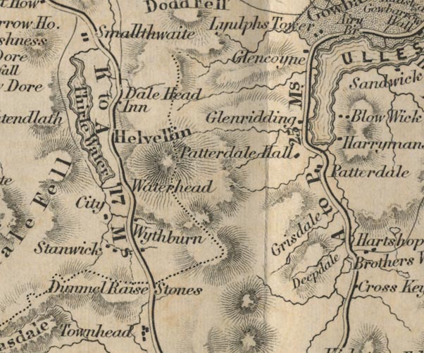 FD02NY31.jpg
 |
Blow Wick
-- 'Blow Wick'
Brothers Water -- 'Brothers Water' -- Outline. City -- 'City' Deepdale -- 'Deepdale' -- Between hill hachures. Dunmail Raise Stones -- 'Dunmail Raise Stones' -- No symbol, at county border. Glencoyne -- 'Glencoyne' Glenridding -- 'Glenridding' Grisedale Tarn, Patterdale (FD02inc) -- Outline. Grisdale -- 'Grisdale' -- Between hill hachures. Harrymans -- 'Harrymans' Helvellin -- 'Helvellin' -- Hill hachuring. Dale Head Inn -- 'Dale Head Inn' Patterdale Hall -- 'Patterdale Hall' Patterdale -- 'Patterdale' road, Ambleside to Keswick (FD02inc) -- 'K to A 17 Ms.' road, Kirkstone to Patterdale (FD02inc) -- 'A to P 25 Ms.' -- Distance from Ambleside to Penrith. road, Patterdale to Penrith (FD02inc) Stanwick -- 'Stanwick' Thirle Water -- 'Thirle Water' -- Outline with form lines. Ulles Water -- Outline with form lines. Wythburn ? -- 'Wythburn' -- 'Waterhead' | |
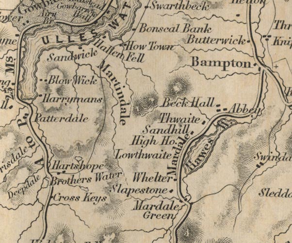 FD02NY41.jpg
 |
Angle Tarn, Martindale (FD02inc)
-- Outline.
Beck Hall -- 'Beck Hall' Bonscal Bank -- 'Bonscal Bank' Cross Keys -- 'Cross Keys' Hallen Fell -- 'Hallen Fell' Hartshope -- 'Hartshope' Hawes Water -- 'Hawes W.' -- Outline with form lines. Hayeswater, Patterdale (FD02inc) -- Outline. High House -- 'High Ho.' How Town -- 'How Town' Lowthwaite -- 'Lowthwaite' Mardale Green -- 'Mardale Green' -- 'Mardale' -- Settlement area. Martindale -- 'Martindale' -- Alongside beck, between hill hachures. road, Mardale to Bampton (FD02inc) Sandhill -- 'Sandhill' Sandwick -- 'Sandwick' Slapestone -- 'Slapestone' Thwaite -- 'Thwaite' track, Gatescarth to Mardale (FD02inc) -- Road. Ulles Water -- 'ULLES WATER' -- Outline with form lines. Whelter -- 'Whelter' | |
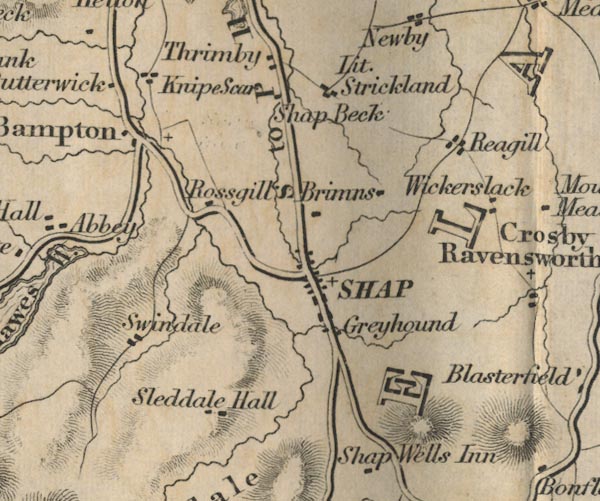 FD02NY51.jpg
 |
Bampton
-- 'Bampton'
Brimns -- 'Brimns' Butterwick -- 'Butterwick' Greyhound -- 'Greyhound' Knipe Scar -- 'Knipe Scar' -- Label by building/s, or the scar? Little Strickland -- 'Lit. Strickland' Reagill -- 'Reagill' road, Kendal to Shap (FD02inc) -- 'K to S 16 Ms.' road, Mardale to Bampton (FD02inc) road, Shap to Penrith (FD02inc) -- 'S to P 11 Ms.' Rossgill -- 'Rossgill' Shap Abbey, Shap Rural (FD02inc) -- 'Abbey' Shap -- 'SHAP' Shap Beck -- 'Shap Beck' -- Building/s? Sleddale Hall -- 'Sleddale Hall' Swindale -- 'Swindale' Thrimby -- 'Thrimby' Wickerslack -- 'Wickerslack' | |
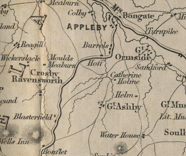 FD02NY61.jpg
 |
Appleby
-- 'APPLEBY'
Blasterfield -- 'Blasterfield' Bongate -- 'Bongate' Catherine Holme -- 'Catherine Holme' Crosby Ravensworth -- 'Crosby Ravensworth' Great Ashby -- 'Gt. Ashby' Great Ormside -- 'Gt. Ormside' Helm -- 'Helm' Moulds Meaburn -- 'Moulds Meaburn' road, Appleby to Bowes (FD02inc) toll gate, Warcop (FD02inc) -- 'Turnpike' -- By the road to Brough. Water House -- 'Water House' | |
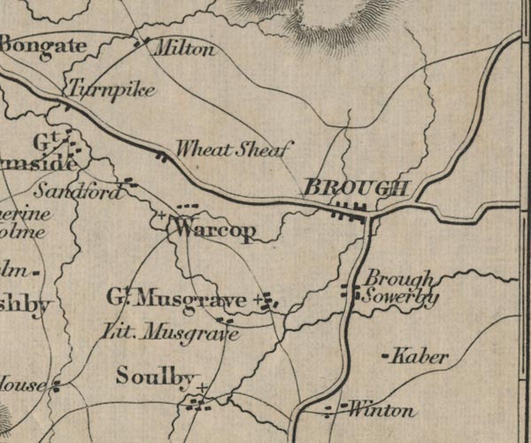 FD02NY71.jpg
 |
Brough Sowerby
-- 'Brough Sowerby'
Brough -- 'BROUGH' Great Musgrave -- 'Gt. Musgrave' Kaber -- 'Kaber' Little Musgrave -- 'Lit. Musgrave' road, Appleby to Bowes (FD02inc) Sandford -- 'Sandford' Warcop -- 'Warcop' Wheat Sheaf -- 'Wheat Sheaf' | |
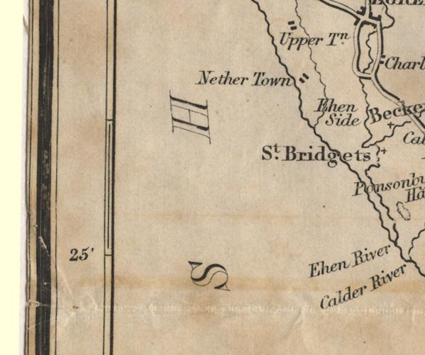 FD02NX90.jpg
 |
Irish Sea
-- 'IRISH SEA'
Nether Town -- 'Nether Town' | |
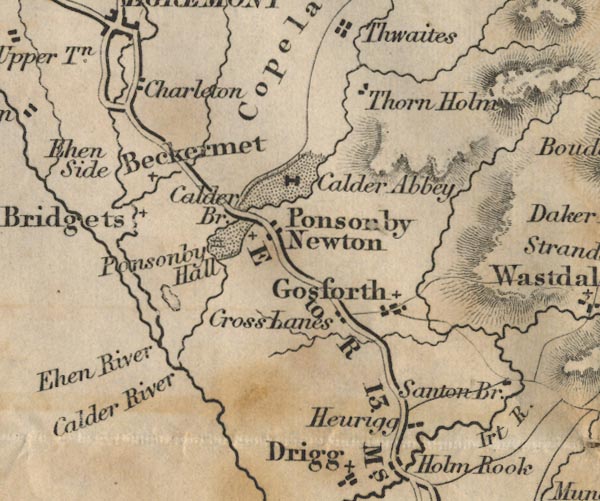 FD02NY00.jpg
 |
Beckermet
-- 'Beckermet'
Calder Abbey -- 'Calder Abbey' -- Building symbol and park. Calder Bridge -- 'Calder Bridge' -- Road crosses stream. Calder River -- 'Calder River' Charleton -- 'Charleton' Cross Lands -- 'Cross Lands' Ehen River -- 'Ehen River' Ehen Side -- 'Ehen Side' -- No symbol. Gosforth -- 'Gosforth' Heurigg -- 'Heurigg' Irt River -- 'Irt R.' Ponsonby Hall -- 'Ponsonby Hall' -- Building and park. Ponsonby Newton -- 'Ponsonby Newton' road, Egremont to Ravenglass (FD02inc) -- 'E to R 13 Ms.' Sellafield Tarn, St Bridget Beckermet (FD02inc) -- Outline. St Bridgets -- 'St. Bridgets' Thorn Holm -- 'Thorn Holm' | |
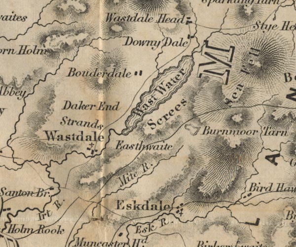 FD02NY10.jpg
 |
Eskdale
-- 'Eskdale'
Bouderdale -- 'Bouderdale' Burnmoor Tarn -- 'Burnmoor Tarn' -- Outline with form lines. Downy Dale -- 'Downy Dale' Easthwaite -- 'Easthwaite' -- No symbol, area? Mite River -- 'Mite R.' Wastdale -- 'Wastdale' Santon Bridge -- 'Santon Bridge' Sea Fell -- 'Sea Fell' -- Hill hachuring. Screes -- 'Screes' -- Hill hachuring. Strands -- 'Strands' Daker End -- 'Daker End' -- No symbol, area? Wast Water -- 'Wast Water' -- Outline with form lines. | |
 FD02NY20.jpg
 |
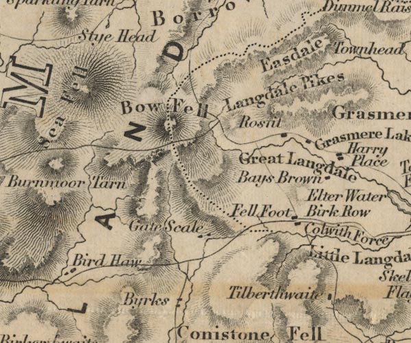
Bays Brown
-- 'Bays Brown'
Bird Haw -- 'Bird Haw' Byrks -- 'Byrks' Bow Fell -- 'Bow Fell' -- Hill hachuring. Copeland -- 'COPELAND' -- Area. Easdale -- 'Easdale' -- Between hill hachures. Fell Foot -- 'Fell Foot' Gate Scale -- 'Gate Scale' Great Langdale -- 'Great Langdale' -- Area, beside beck. Harry Place -- 'Harry Place' Birk Row -- 'Birk Row' Langdale Pikes -- 'Langdale Pikes' -- Hill hachuring. Rossett, Lakes (FD02inc) -- 'Ros[ ]it' Tilberthwaite -- 'Tilberthwaite' | |
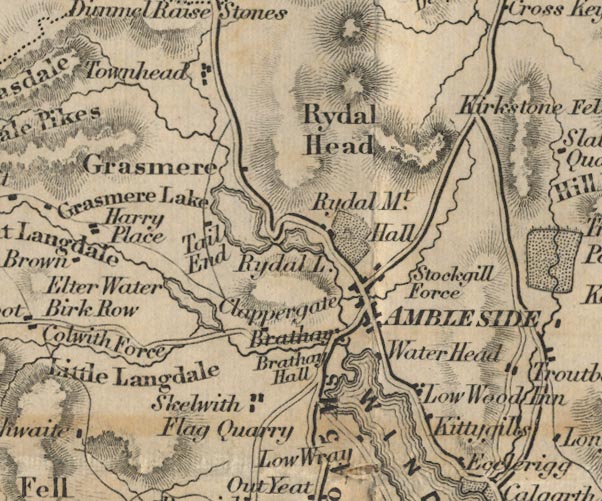 FD02NY30.jpg
 |
Ambleside
-- 'AMBLESIDE'
Brathay Hall -- 'Brathay Hall' Brathay Quarries, Skelwith (FD02inc) ? -- 'Flag Quarry' -- At Skelwith. Brathay -- 'Brathay' Clappergate -- 'Clappergate' Colwith Force -- 'Colwith Force' Tail End -- 'Tail End' Elter Water -- 'Elter Water' -- Outline with form lines. Grasmere Lake -- 'Grasmere Lake' -- Outline with form lines. Grasmere -- 'Grasmere' Kittygills -- 'Kittygills' Little Langdale -- 'Little Langdale' -- Area. Low Wood Inn -- 'Low Wood Inn' Low Wray -- 'Low Wray' road, Ambleside to Hawkshead (FD02inc) -- 'H to A 5 Ms.' road, Ambleside to Keswick (FD02inc) -- 'K to A 17 Ms.' road, Ambleside to Kirkstone (FD02inc) road, Kirkstone to Patterdale (FD02inc) -- 'A to P 25 Ms.' -- Distance from Ambleside to Penrith. road, Windermere to Ambleside (FD02inc) -- 'A to K 13 1/2 Ms.' -- Distance Kendal to Ambleside; the old road ignores Windermere, which didn't much exist. Rydal Hall, Rydal (FD02inc) -- 'Hall' -- Building and park. Rydal Head -- 'Rydal Head' -- Hill hachuring. Rydal Mount -- 'Rydal Mt.' Rydal Lake -- 'Rydal L.' -- Outline with form lines. Skelwith -- 'Skelwith' Stockgill Force -- 'Stockgill Force' Townhead -- 'Townhead' Water Head -- 'Water Head' Tower Wood -- Outline with from lines. | |
 FD02NY40.jpg
 |
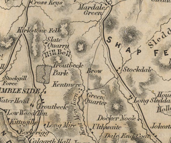
Docker Nook
-- 'Docker Nook'
Green Quarter -- 'Green Quarter' Brow ? -- 'Brow' Hill Bell -- 'Hill Bell' -- Hill hachuring. Kent Mere Tarn -- 'Kent Mere Tarn' -- Outline with form lines. Long Mire -- 'Long Mire' Long Sleddale -- 'Long Sleddale' quarry, Kentmere (3) (FD02inc) ? -- 'Slate Quarry' Kirkstone Fell ? -- 'Kirkstone Fell' -- Hill hachuring. road, Garnett Bridge to Sadgill (FD02inc) -- Road. Shap Fells -- 'SHAP FELLS' -- Hill hachuring. Stockdale -- 'Stockdale' track, Gatescarth to Mardale (FD02inc) -- Road. track, Sadgill to Gatesgarth (FD02inc) -- Road. Troutbeck Park -- 'Troutbeck Park' -- Park. Troutbeck -- 'Troutbeck' -- Dispersed settlement. Ulthwaite -- 'Ulthwaite' | |
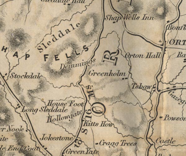 FD02NY50.jpg
 |
Demmings
-- 'Demmings'
Greenholm -- 'Greenholm' House Foot -- 'House Foot' Hollowgate -- 'Hollowgate' Kitts How -- 'Kitts How' Jokestone -- 'Jokestone' road, Kendal to Shap (FD02inc) -- 'K to S 16 Ms.' Shap Fells -- 'SHAP FELLS' -- Hill hachuring. Shap Wells Inn -- 'Shap Wells Inn' Sleddale -- 'Sleddale' -- Between hill hachures. | |
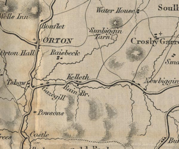 FD02NY60.jpg
 |
Bonflet ?
-- 'Bonflet'
Gazegill -- 'Gazegill' Kelleth -- 'Kelleth' Newbiggin -- 'Newbiggin' Orton Hall -- 'Orton Hall' Orton -- 'ORTON' Powsons -- 'Powsons' Raisbeck -- 'Raisbeck' Rain Bridge -- 'Rain Br.' -- Road across stream. Sunbiggin Tarn -- 'Sunbiggin Tarn' -- Outline. Tebaw -- 'Tebaw' | |
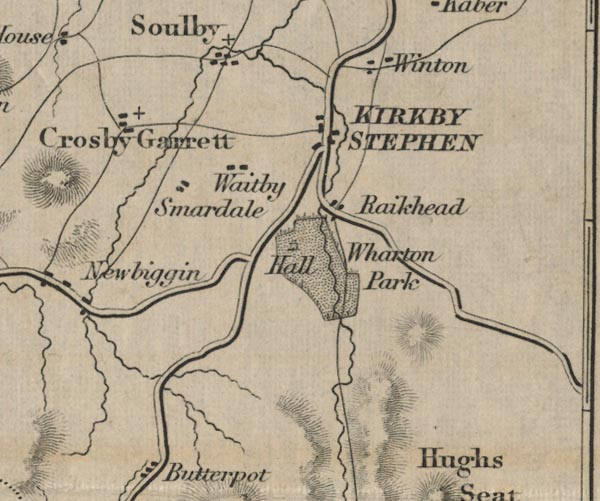 FD02NY70.jpg
 |
Crosby Garrett
-- 'Crosby Garrett'
Kirkby Stephen -- 'KIRKBY STEPHEN' Raikhead -- 'Raikhead' Smardale -- 'Smardale' Soulby -- 'Soulby' Waitby -- 'Waitby' Wharton Park -- 'Wharton Park / Hall' -- Building and park. Winton -- 'Winton' | |
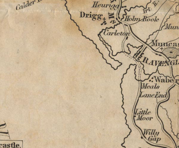 FD02SD09.jpg
 |
Carleton ?
-- 'Carleton'
Drigg -- 'Drigg' Meals ? -- 'Meals' Holm Rook -- 'Holm Rook' Lane End -- 'Lane End' Little Moor -- 'Little Moor' Ravenglass -- 'RAVENGLASS' road, Egremont to Ravenglass (FD02inc) -- 'E to R 13 Ms.' road, Ravenglass to Broughton (FD02inc) -- 'R to B 11 Ms.' | |
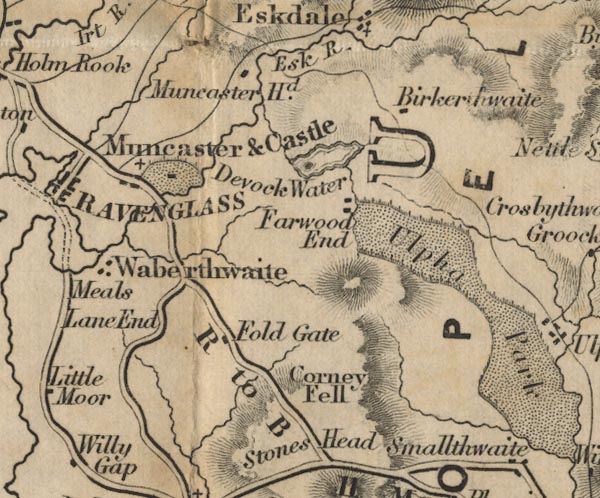 FD02SD19.jpg
 |
Birkerthwaite
-- 'Birkerthwaite'
Copeland -- 'COPELAND' -- Area. Corney Fell -- 'Corney Fell' -- Hill hachuring. Devock Water -- 'Devock Water' -- Outline with form lines. Esk River -- 'Esk R.' Fold Gate -- 'Fold Gate' Waberthwaite -- 'Waberthwaite' Muncaster Castle -- 'Muncaster & Castle' -- Building and park. Muncaster Head -- 'Muncaster Hd.' Muncaster -- 'Muncaster & Castle' road, Ravenglass to Broughton (FD02inc) -- 'R to B 11 Ms.' Stones Head -- 'Stones Head' -- No symbol, or hill hachuring. Ulpha Park -- 'Ulpha Park' -- Park. Farwood End -- 'Farwood End' | |
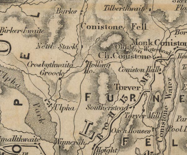 FD02SD29.jpg
 |
Conistone Fell
-- 'Conistone Fell' -- Hill hachuring.
Crosbythwaite Crook ? -- 'Crosbythwaite Crook' Furness Fells -- 'FURNESS FELLS' -- Hill hachuring. Holling House -- 'Holling Ho.' Nettle Stack -- 'Nettle Stack' Old Man -- 'Old Man' -- Hill hachuring. Oxen Houses -- 'Oxen Houses' road, Hawkshead to Broughton (FD02inc) -- 'B to H 13 Ms.' Southerstead -- 'Southerstead' Torver Mill -- 'Torver Mill' Torver -- 'Torver' Ulpha Park -- 'Ulpha Park' -- Park. Ulpha -- 'Ulpha' | |
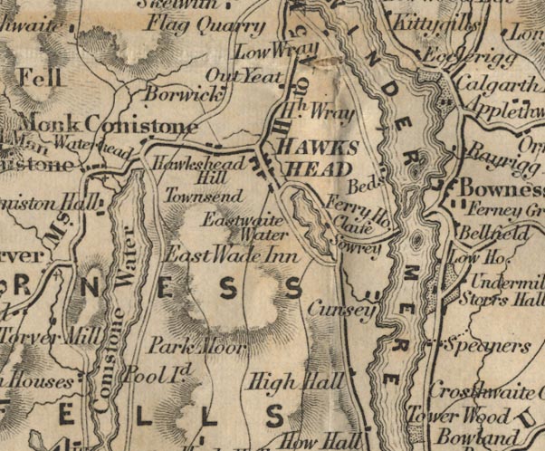 FD02SD39.jpg
 |
Borwick ?
-- 'Borwick'
Bowness -- 'Bowness' Calgarth Hall -- 'Calgarth Hall' -- Building and park. Claife -- 'Claife' Conistone Water -- 'Conistone Water' -- Outline with form lines. Church Conistone -- 'Ch. Conistone' Cunsey -- 'Cunsey' East Wade Inn -- 'East Wade Inn' Ecclerigg ? -- 'Ecclerigg' Eastwaite Water -- 'Eastwaite Water' -- Outline with form lines. Sowrey -- 'Sowrey' Ferry House -- 'Ferry Ho.' Speaners -- 'Speaners' High Hall -- 'High Hall' Hawkshead Hill -- 'Hawkshead Hill' Hawkshead -- 'HAWKSHEAD' High Wray -- 'Hh. Wray' Townsend ? -- 'Townsend' Monk Conistone -- 'Monk Conistone' Sowrey -- 'Sowrey' Out Yeat -- 'Out Yeat' Park Moor -- 'Park Moor' -- Area. Pool Island -- 'Pool Id.' road, Ambleside to Hawkshead (FD02inc) -- 'H to A 5 Ms.' road, Hawkshead to Broughton (FD02inc) -- 'B to H 13 Ms.' Beds -- 'Beds' Storrs Hall -- 'Storrs Hall' -- Building and park. Waterhead -- 'Waterhead' Winder Mere -- 'WINDER MERE' -- Outline with form lines. | |
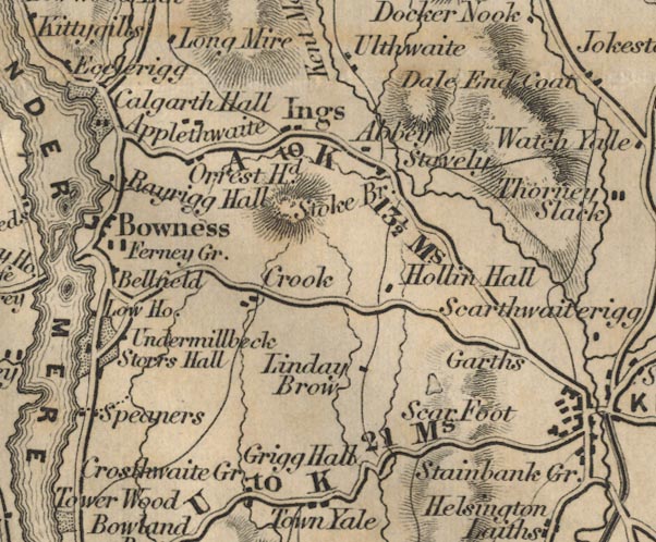 FD02SD49.jpg
 |
Abbey ?
-- 'Abbey'
Applethwaite -- 'Applethwaite' Bellfield -- 'Bellfield' Crook -- 'Crook' Crosthwaite Green -- 'Crosthwaite Gr.' Cunswick Tarn, Underbarrow and Bradleyfield (FD02inc) ? -- Outline. Ferney Green -- 'Ferney Gr.' Grigg Hall -- 'Grigg Hall' Hollin Hall -- 'Hollin Hall' Ings -- 'Ings' Linday Brow -- 'Linday Brow' Orrest Head -- 'Orrest Hd.' -- Hill hachuring. Rayrigg Hall -- 'Rayrigg Hall' road, Kendal to Ulverston (FD02inc) -- 'U to K 21 Ms.' road, Kendal to Windermere (FD02inc) -- 'A to K 13 1/2 Ms.' -- Distance Kendal to Ambleside; the old road ignores Windermere, which didn't much exist. road, Windermere to Ambleside (FD02inc) -- 'A to K 13 1/2 Ms.' -- Distance Kendal to Ambleside; the old road ignores Windermere, which didn't much exist. Scar Foot -- 'Scar Foot' Stavely -- 'Stavely' Stoke Bridge -- 'Stoke Br.' -- Road across stream? Undermillbeck -- 'Undermillbeck' | |
 FD02SD59.jpg
 |
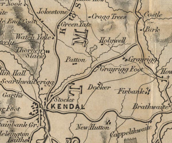
Cragg Trees
-- 'Cragg Trees'
Dale End Coat -- 'Dale End Coat' Docker -- 'Docker' Green Yate -- 'Green Yate' Grayrigg Foot -- 'Grayrigg Foot' Grayrigg -- 'Grayrigg' Park ? -- 'Park' Holywell -- 'Holywell' Kendal -- 'KENDAL' Lancaster Canal (FD02inc) Park ? -- 'Park' New Hutton -- 'New Hutton' Patton ? -- 'Patton' road, A6 to Garnett Bridge (FD02inc) -- Road. road, Garnett Bridge to Sadgill (FD02inc) -- Road. road, Kendal to Shap (FD02inc) -- 'K to S 16 Ms.' road, Kendal to Ulverston (FD02inc) -- 'U to K 21 Ms.' road, Kendal to Windermere (FD02inc) -- 'A to K 13 1/2 Ms.' -- Distance Kendal to Ambleside; the old road ignores Windermere, which didn't much exist. road, Lancaster to Kendal (FD02inc) -- 'B to K 11 Ms.' -- 'L to B 11 Ms.' -- Distance to then from Burton. roman fort, Low Borrow Bridge (FD02inc) -- 'Castle' Stocks -- 'Stocks' Scarthwaiterigg -- 'Scarthwaiterigg' Stainbank Green -- 'Stainbank Gr.' Thorney Slack -- 'Thorney Slack' Watch Yale -- 'Watch Yale' | |
 FD02SD69.jpg
 |
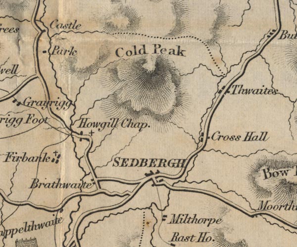
Brathwaite
-- 'Brathwaite'
Cold Peak ? -- 'Cold Peak' -- Hill hachuring. Cappelthwaite -- 'Cappelthwaite' Thwaites -- 'Thwaites' Cross Hall -- 'Cross Hall' Firbank -- 'Firbank' Howgill Chapel -- 'Howgill Chap.' Milthorpe -- 'Milthorpe' Sedbergh -- 'SEDBERGH' | |
 FD02SD79.jpg
 |
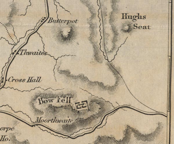
Bow Fell
-- 'Bow Fell' -- Hill hachuring.
Butterpot -- 'Butterpot' Hugh Seat -- 'Hugh Seat' -- Hill hachuring. Moorthwaite -- 'Moorthwaite' | |
 FD02SD08.jpg
 |
Highton ?
-- 'Highton'
Willy Gap -- 'Willy Gap' | |
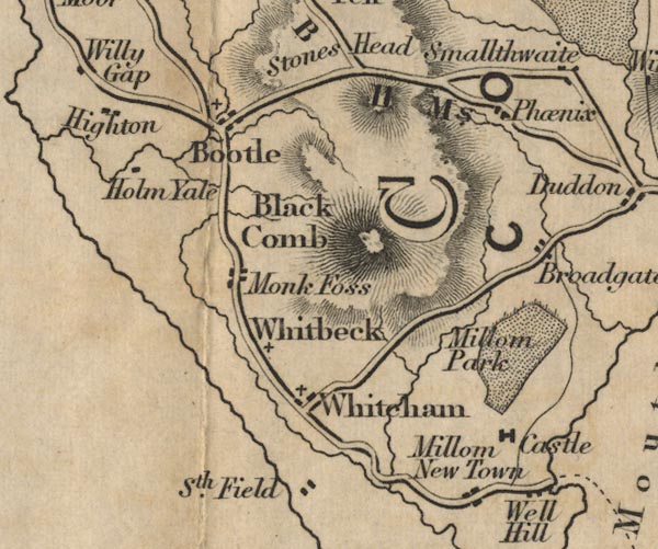 FD02SD18.jpg
 |
Black Comb
-- 'Black Comb' -- Hill hachuring.
Bootle -- 'Bootle' Broadgate -- 'Broadgate' Copeland -- 'COPELAND' -- Area. Phoenix -- 'Phoenix' Holm Yale -- 'Holm Yale' Millom Castle, Millom (FD02inc) -- 'Castle' Millom Park -- 'Millom Park' -- Park. Millom New Town -- 'Millom New Town' Monk Foss -- 'Monk Foss' road, Ravenglass to Broughton (FD02inc) -- 'R to B 11 Ms.' South Field -- 'Sth. Field' Well Hill -- 'Well Hill' Whitcham -- 'Whitcham' Whitbeck -- 'Whitbeck' | |
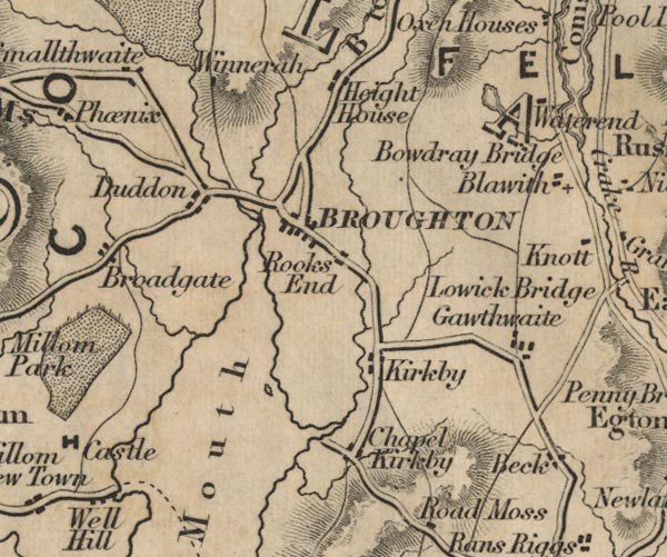 FD02SD28.jpg
 |
Beacon Tarn, Blawith and Subberthwaite (FD02inc)
-- Outline with form lines.
Chapel Kirkby -- 'Chapel Kirkby' Blawith -- 'Blawith' Bowdray Bridge -- 'Bowdray Bridge' Beck -- 'Beck' Broughton -- 'BROUGHTON' Duddon -- 'Duddon' Duddon Mouth -- 'Duddon Mouth' Gawthwaite -- 'Gawthwaite' Height House -- 'Height House' Waterend ? -- 'Waterend' Winnerah -- 'Winnerah' Kirkby -- 'Kirkby' Levers Water, Coniston (FD02inc) -- Outline with form lines. Waterend ? -- 'Waterend' Winnerah -- 'Winnerah' road, Hawkshead to Broughton (FD02inc) -- 'B to H 13 Ms.' road, Ravenglass to Broughton (FD02inc) -- 'R to B 11 Ms.' Smallthwaite -- 'Smallthwaite' Rooks End ? -- 'Rooks End' | |
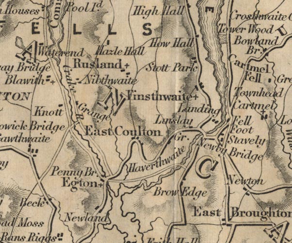 FD02SD38.jpg
 |
East Coulton
-- 'East Coulton'
Conistone Water Crake River -- 'Crake R.' Fell Foot -- 'Fell Foot' Finsthwaite -- 'Finsthwaite' Furness Fells -- 'FURNESS FELLS' -- Hill hachuring. How Hall -- 'How Hall' Knott -- 'Knott' Egton ? -- 'Egton' Haverthwaite -- 'Haverthwaite' Hazle Hall -- 'Hazle Hall' Brow Edge -- 'Brow Edge' Stott Park -- 'Stott Park' Landing How, Colton (FD02inc) ? -- 'Landing' Linslay Green ? -- 'Linslay Gr.' Nibthwaite ? -- 'Nibthwaite' Lowick Bridge -- 'Lowick Bridge' -- Road across stream. Newby Bridge -- 'Newby Bridge' -- Road across stream. Newland -- 'Newland' Grange ? -- 'Grange' Penny Bridge -- 'Penny Bridge' road, Kendal to Ulverston (FD02inc) -- 'U to K 21 Ms.' Rusland -- 'Rusland' Stavely -- 'Stavely' Townhead -- 'Townhead' -- Located where? Tower Wood -- 'Tower Wood' -- Park. | |
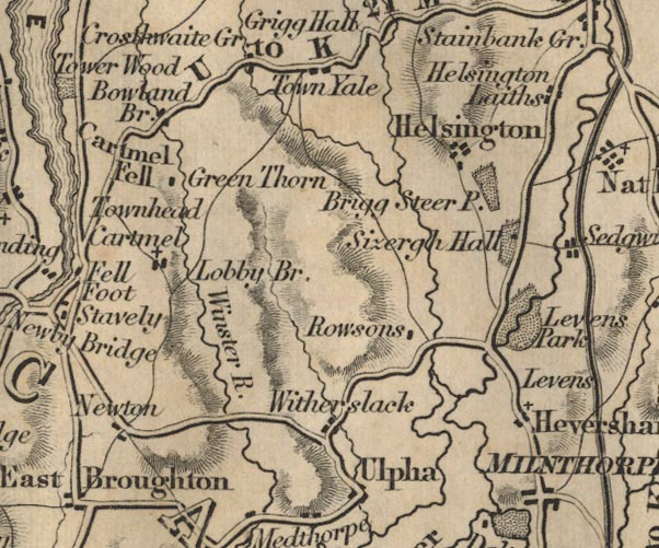 FD02SD48.jpg
 |
Bowland Bridge
-- 'Bowland Br'
Brigg Steer Park -- 'Brigg Steer P.' -- Park. Cartmel Fell -- 'Cartmel Fell' Cartmel -- 'Cartmel' Green Thorn -- 'Green Thorn' Helsington ? -- 'Helsington' -- 'Helsington Laithes' Heversham -- 'Heversham' Newton -- 'Newton' Levens Park -- 'Levens Park' -- Park. Levens -- 'Levens' Lobby Bridge -- 'Lobby Br.' -- Road across stream. Milnthorpe -- 'MILNTHORPE' Rowsons -- 'Rowsons' road, Kendal to Ulverston (FD02inc) -- 'U to K 21 Ms.' Sizergh Hall -- 'Sizergh Hall' -- Building and park. Town Yale -- 'Town Yale' Ulpha -- 'Ulpha' Winster River -- 'Winster R.' Witherslack -- 'Witherslack' | |
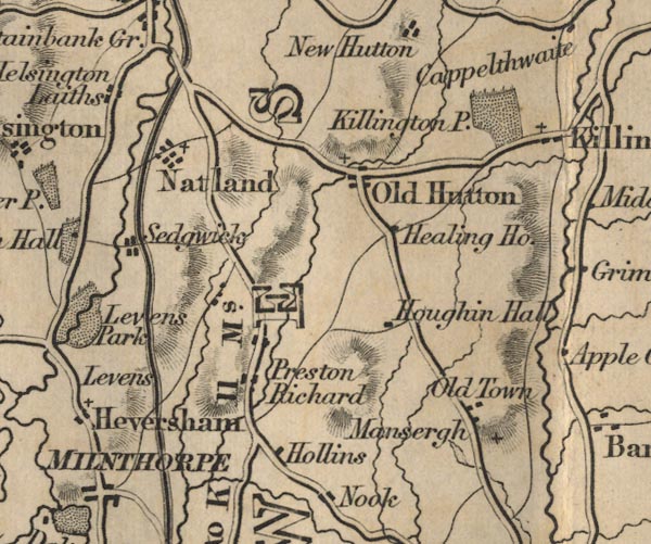 FD02SD58.jpg
 |
Preston Richard ?
-- 'Preston Richard'
Houghin Hall -- 'Houghin Hall' Healing House -- 'Healing Ho.' Hollins -- 'Hollins' Killington Park -- 'Killington P.' -- Park. Lancaster Canal (FD02inc) Mansergh -- 'Mansergh' Natland -- 'Natland' Old Hutton -- 'Old Hutton' Old Town -- 'Old Town' road, Lancaster to Kendal (FD02inc) -- 'B to K 11 Ms.' -- 'L to B 11 Ms.' -- Distance to then from Burton. Sedgwick -- 'Sedgwick' | |
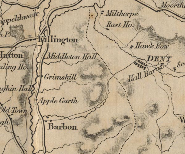 FD02SD68.jpg
 |
Apple Garth
-- 'Apple Garth'
Barbon -- 'Barbon' Dent -- 'DENT' Grimshill -- 'Grimshill' Hawk Row ? -- 'Hawk Row' Killington -- 'Killington' Middleton Hall -- 'Middleton Hall' Rast House -- 'Rast Ho.' | |
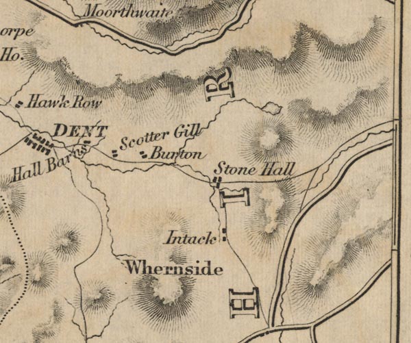 FD02SD78.jpg
 |
Intack
-- 'Intack'
Burton ? -- 'Burton' Hall Barns -- 'Hall Barns' Scotter Gill -- 'Scotter Gill' Stone Hall ? -- 'Stone Hall' Whernside -- 'Whernside' -- Hill hachuring. | |
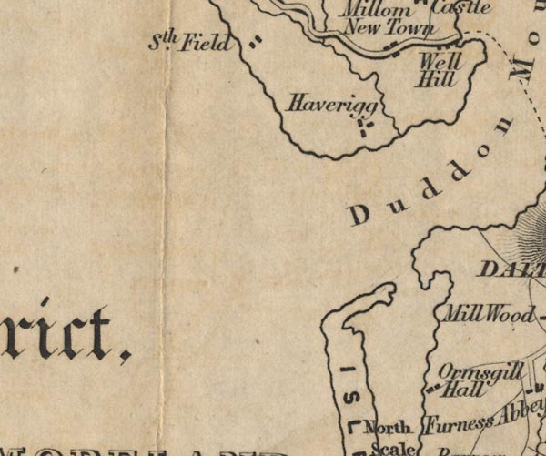 FD02SD17.jpg
 |
Haverigg
-- 'Haverigg'
Isle of Walney Ormsgill Hall -- 'Ormsgill Hall' | |
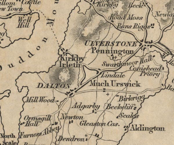 FD02SD27.jpg
 |
Aldingham
-- 'Aldingham'
Beckcliff ? -- 'Beckcliff' Birkrigg -- 'Birkrigg' Dalton -- 'DALTON' Duddon Mouth -- 'Duddon Mouth' Furness Abbey -- 'Furness Abbey' Gleaston Castle -- 'Gleaston Cas.' Much Urswick ? -- 'Much Urswick' Kirkby Ireleth -- 'Kirkby Ireleth' Lindale -- 'Lindale' Mill Wood -- 'Mill Wood' Newton -- 'Newton' Pennington -- 'Pennington' Road Moss -- 'Road Moss' road, Kendal to Ulverston (FD02inc) -- 'U to K 21 Ms.' sands road, Duddon Sands (FD02inc) -- Dotted line from Kirkby Ireleth to road to Millom. Scales -- 'Scales' Adgarby -- 'Adgarby' Ulverstone -- 'ULVERSTONE' | |
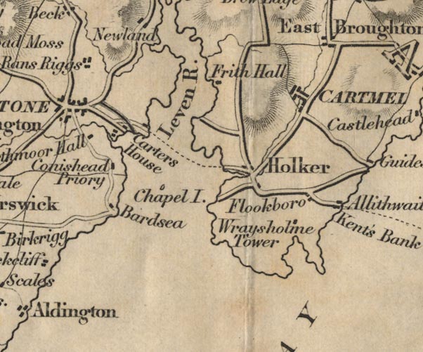 FD02SD37.jpg
 |
Allithwaite
-- 'Allithwaite'
Bardsea -- 'Bardsea' Carters House -- 'Carters House' Cartmel -- 'CARTMEL' Chapel Island -- 'Chapel I.' -- Island. Conishead Prior -- 'Conishead Prior' East Broughton -- 'East Broughton' Flookboro -- 'Flookboro' Frith Hall -- 'Frith Hall' Holker -- 'Holker' Kent's Bank -- 'Kent's Bank' Leven River -- 'Leven R.' Rans Riggs -- 'Rans Riggs' Morecambe Bay -- 'MORECAMBE BAY' road, Kendal to Ulverston (FD02inc) -- 'U to K 21 Ms.' sands road, Leven Sands (FD02inc) -- From near Holker to the Carters House below Ulverston. Swarthmoor Hall -- 'Swarthmoor Hall' Ulverston Canal (FD02inc) Wraysholme Tower -- 'Wraysholme Tower' | |
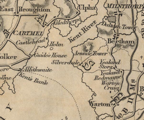 FD02SD47.jpg
 |
Arnside Tower
-- 'Arnside Tower'
Beetham -- 'Beetham' Castlehead -- 'Castlehead' Daltam Tower -- 'Daltam Tower' -- Building and park. Guide's House -- 'Guide's House' Holm -- 'Holm' -- Island. Kent River -- 'Kent River' -- 'Kent River' Medthorpe -- 'Medthorpe' Morecambe Bay -- 'MORECAMBE BAY' sands road, Lancaster Sands (FD02inc) -- 'from Hest Bank to Kent's Bank' Silverdale -- 'Silverdale' Warton Craig -- 'Warton Craig' Warton -- 'Warton' Yealand Redmayne -- 'Yealand Redmayne' Yealand Stors -- 'Yealand Stors' | |
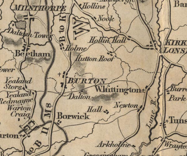 FD02SD57.jpg
 |
Borwick
-- 'Borwick'
Burton -- 'BURTON' Docker Hall, Lancashire (FD02inc) ? -- 'Hall' Hollin Hall -- 'Hollin Hall' Holme -- 'Holme' Hutton Roof -- 'Hutton Roof' Kirkby Lonsdale -- 'KIRKBY LONSDALE' Lancaster Canal (FD02inc) Lune River -- 'Lune R.' Newton -- 'Newton' Nook -- 'Nook' road, Lancaster to Kendal (FD02inc) -- 'B to K 11 Ms.' -- 'L to B 11 Ms.' -- Distance to then from Burton. Whittington -- 'Whittington' | |
 FD02SD67.jpg
 |
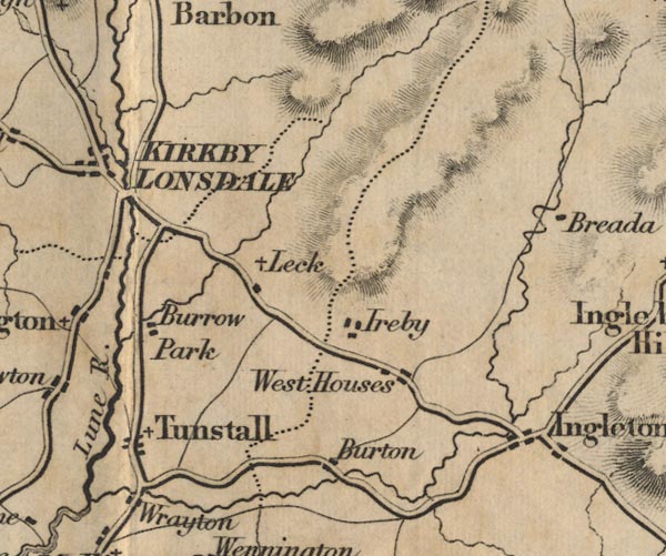
Burrow Park
-- 'Burrow Park'
Burton -- 'Burton' Angleton -- 'Angleton' Ireby -- 'Ireby' Leck -- 'Leck' Tunstall -- 'Tunstall' West Houses -- 'West Houses' Wrayton -- 'Wrayton' | |
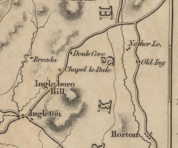 FD02SD77.jpg
 |
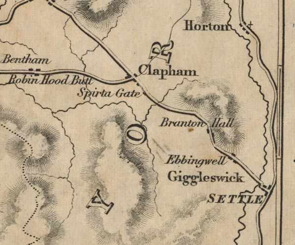
Breada
-- 'Breada'
Branton Hall ? -- 'Branton Hall' Chapel le Dale -- 'Chapel le Dale' Clapham -- 'Clapham' Giggleswick -- 'Giggleswick' Douk Cove ? -- 'Douk Cove' Horton -- 'Horton' Ingleboro Hill -- 'Ingleboro Hill' -- Hill hachuring. Nether Lodge -- 'Nether Lo.' Old Ing -- 'Old Ing' Spirta Gate -- 'Spirta Gate' Settle -- 'SETTLE' Ebbingwell -- 'Ebbingwell' | |
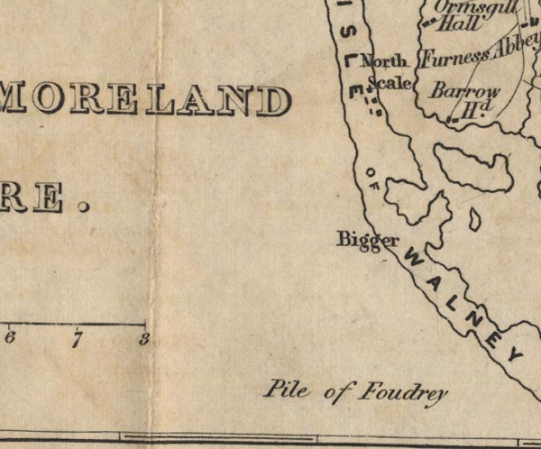 FD02SD16.jpg
 |
Barrow Head
-- 'Barrow Hd.'
Bigger -- 'Bigger' Isle of Walney -- 'ISLE OF WALNEY' North Scale -- 'North Scale' Pile of Foudry -- 'Pile of Foudry' -- The label lying about in the sea, near no feature. | |
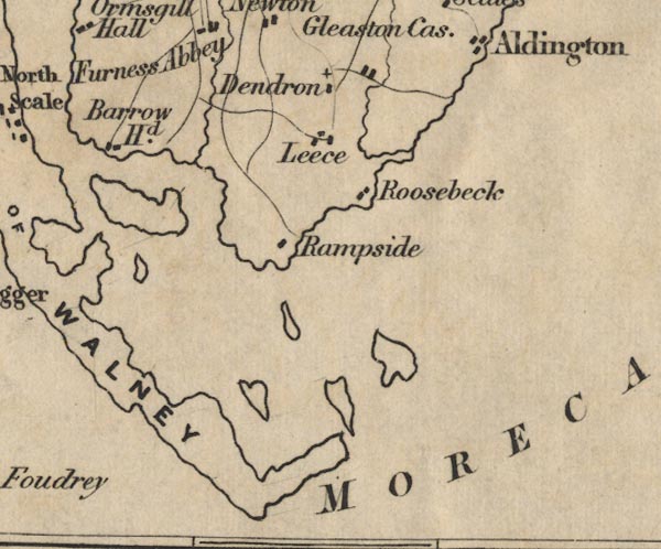 FD02SD26.jpg
 |
Dendron
-- 'Dendron'
Isle of Walney Leece -- 'Leece' Morecambe Bay -- 'MORECAMBE BAY' Rampside -- 'Rampside' Roosebeck -- 'Roosebeck' | |
 FD02SD36.jpg
 |
Morecambe Bay
-- 'MORECAMBE BAY'
| |
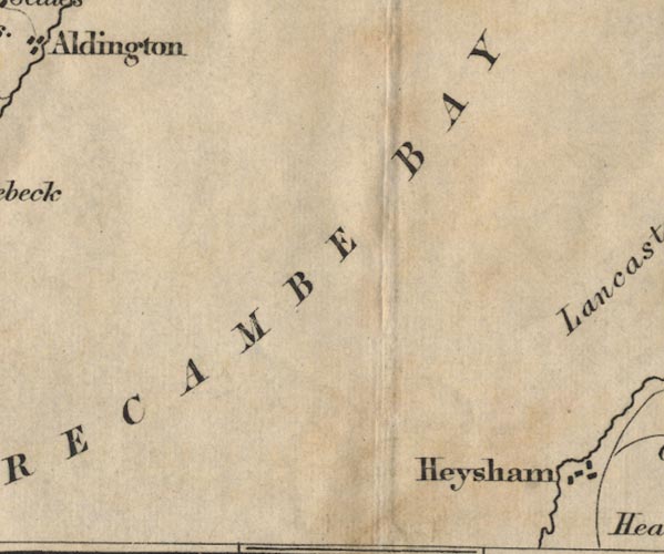
 FD02SD46.jpg
 |
Bolton by the Sands
-- 'Bolton by the Sands'
Bulk -- 'Bulk' Carnforth -- 'Carnforth' Halton -- 'Halton' Heaton -- 'Heaton' Hest Bank -- 'Hest Bank' Heysham -- 'Heysham' Keer River -- 'Keer R.' Lancaster Canal (FD02inc) Lancaster Sands -- 'Lancaster Sands' Lancaster -- 'LANCASTER' Nether Kellet -- 'Nether Kellet' Oxcliff -- 'Oxcliff' Poulton -- 'Poulton' road, Lancaster to Kendal (FD02inc) -- 'B to K 11 Ms.' -- 'L to B 11 Ms.' -- Distance to then from Burton. sands road, Lancaster Sands (FD02inc) -- 'from Hest Bank to Kent's Bank' Slyne -- 'Slyne' Thwaite End -- 'Thwaite End' | |
 FD02SD56.jpg
 |
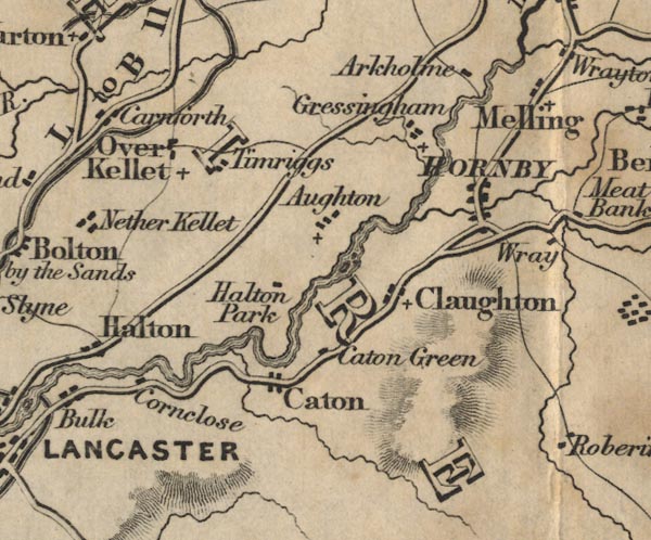
Arkholme
-- 'Arkholme'
Aughton -- 'Aughton' Caton Green -- 'Caton Green' Caton -- 'Caton' Claughton -- 'Claughton' Cornclose -- 'Cornclose' Gressingham -- 'Gressingham' Halton Park -- 'Halton Park' Hornby -- 'HORNBY' Lancaster Canal (FD02inc) Melling -- 'Melling' Over Kellet -- 'Over Kellet' road, Lancaster to Kendal (FD02inc) -- 'B to K 11 Ms.' -- 'L to B 11 Ms.' -- Distance to then from Burton. | |
 FD02SD66.jpg
 |
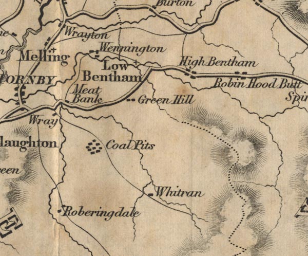
Robin Hood Butt ?
-- 'Robin Hood Butt'
coal mine, Wray with Bolton (FD02inc) -- 'Coal Pits' Green Hill ? -- 'Green Hill' High Bentham -- 'High Bentham' Low Bentham -- 'Low Bentham' Meat Bank -- 'Meat Bank' Roberingdale -- 'Roberingdale' Wennington -- 'Wennington' Whitran ? -- 'Whitran' Wray -- 'Wray' | |
 FD02SD76.jpg
 | ||
 Lakes Guides menu.