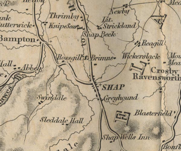
 Ford 1839 map NY51


|

|
|
|
gazetteer links places may or may not be labelled on the map |
||

|
-- Bampton -- "Bampton" |
|
|
|
-- Brinns Farm -- "Brimns" |
|
|
|
-- Butterwick -- "Butterwick" |
|
|
|
-- Greyhound Hotel -- "Greyhound" |
|
|
|
-- Knipe Scar -- "Knipe Scar" |
|
|
|
-- Little Strickland -- "Lit. Strickland" |
|
|
|
-- Reagill -- "Reagill" |
|
|
|
-- Kendal to Shap -- "K to S 16 Ms." |
|
|
|
-- Mardale to Bampton |
|
|
|
-- Shap to Penrith -- "S to P 11 Ms." |
|
|
|
-- Rosgill -- "Rossgill" |
|
|
|
-- Shap Abbey -- "Abbey" |
|
|
|
-- Shap -- "SHAP" |
|
|
|
-- Shapbeck -- "Shap Beck" |
|
|
|
-- Sleddale Hall -- "Sleddale Hall" |
|
|
|
-- Swindale -- "Swindale" |
|
|
|
-- Thrimby -- "Thrimby" |
|
|
|
-- Wickerslack -- "Wickerslack" |
|
|
civil parishes The area roughly includes parts of parishes:- Newby Shap Little Strickland Sleagill Bampton Shap Rural Longsleddale Crosby Ravensworth Thrimby Lowther |
||
|
|
||
|
|
Lakes Guides menu. | |