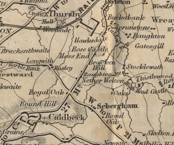
 Ford 1839 map NY34


|

|
|
|
gazetteer links places may or may not be labelled on the map |
||

|
-- Breconhill -- "Bracken Hill" |
|
|
|
-- Buckabank -- "Buckabank" |
|
|
|
-- Caldbeck -- "Caldbeck" |
|
|
|
-- Calder, River -- "Calder River" -- "Calder
R." -- "Calder R." |
|
|
|
-- Crofton Hall -- "Crofton Hall" |
|
|
|
-- Gaitsgill -- "Gatesgill" |
|
|
|
-- Hawksdale -- "Hawksdale" |
|
|
|
-- High Head Castle -- "High Head Ca." |
|
|
|
-- Longwath -- "Longwith" |
|
|
|
-- Maryport and Carlisle Railway -- "MARYPORT AND CARLISLE
RAILWAY" |
|
|
|
-- Moss End -- "Moss End" |
|
|
|
-- Nether Welton -- "Nether Welton" |
|
|
|
-- Oaks -- "Oaks" |
|
|
|
-- Raughton Head -- "Raughton Hd." |
|
|
|
-- Raughton -- "Raughton" |
|
|
|
-- Keswick to Carlisle -- "K to C 27 Ms." -- "K to
C 27 Ms." |
|
|
|
-- Penrith to Wigton -- "W to P 21 Ms." |
|
|
|
-- Rose Castle -- "Rose Castle" |
|
|
|
-- Rosley -- "Rosley" |
|
|
|
-- Roundhill -- "Round Hill" |
|
|
|
-- Royal Oak -- "Royal Oak" |
|
|
|
-- Royal Oak -- "Royal Oak" |
|
|
|
-- Sebergham -- "Sebergham" |
|
|
|
-- Stockdalewath -- "Stocklewath" |
|
|
|
-- Thistlewood -- "Thistlewood" |
|
|
|
-- West Woodside -- "Woodside" |
|
|
civil parishes The area roughly includes parts of parishes:- Thursby Dalston St Cuthbert Without Caldbeck Westward Castle Sowerby Skelton Sebergham |
||
|
|
||
|
|
Lakes Guides menu. | |