 Burghley 1590
 |
 |
|
|
Places Identified
Facsimile map, A Platt of the Opposete Border of Scotland to ye West Marches of England, parts of Cumberland and Scotland including the Dabatable Land, from a manuscript drawn for William Cecil, Lord Burghley, about 1590, published by R B Armstrong, 1897. NB: each image includes an overlap, places in the overlap are not listed. The images are roughly equivalent to ngr 10Km squares and are listed from top left to bottom right. | ||
|
All places in Cumberland have been identified, but only
places immediately across the border in Scotland have been
attempted. The Old Cumbria Gazetteer aims for Cumbria!
| ||
 M048NT40.jpg
 |
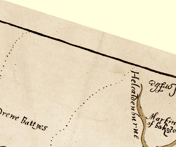
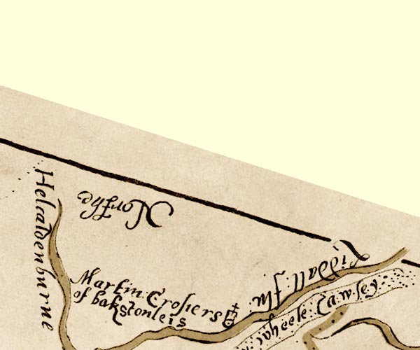
Caddroun Burn -- river -- NY5898 (etc)
-- 'Helcaldenburne' -- river
| |
 M048NT50.jpg
 |
Backstonelees (?) -- locality -- NY9860 (?)
-- 'Martin Crosiers of bakstonleis' -- circle, tower, cross
Liddel Water -- river -- boundary -- national boundary -- county boundary -- NY4377 (etc) -- 'Liddall flu' -- river Wheel Causeway -- track -- NY6098 (etc) -- 'y wheele Cawsey' -- track | |
 M048NY19.jpg
 |
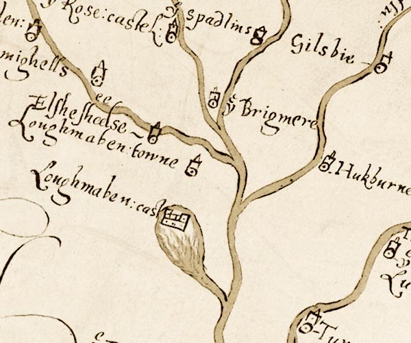
Lochmaben Castle -- castle -- NY0981
-- 'Loughmaben: cast' -- walls, two towers
| |
 M048NY49.jpg
 |
Clints, The -- locality -- NY5391
-- 'ye Clints' -- circle, tower, cross
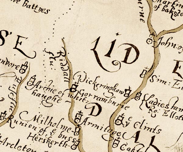
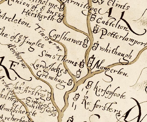
Gorrenberry -- building/s -- NY46959712 -- 'Gorramburie' -- circle, tower, cross Hermitage Castle -- castle -- NY49619605 -- 'Armitage' -- circle, tower, cross Hermitage Cottage -- building/s -- NY50769545 -- 'Milholme' -- circle, tower perhaps Hermitage Water -- river -- NY4896 (etc) -- 'Riddall flu' -- river Larriston -- building/s -- NY5494 -- 'Ladiestaine Ro: Ellotts' -- circle, tower Pickeringhaw (?) -- locality -- NY5494 (?) -- 'Pickeringhaw' -- circle, tower Prickinghaugh (?) -- locality -- NY5191 (guess) -- 'Pickeringhaw' -- circle, tower, cross? Riccarton Tower -- tower -- NY54409582 -- 'Sim Ellotts' -- circle, tower perhaps | |
 M048NY59.jpg
 |
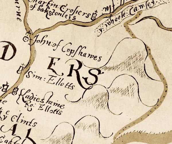
Hudshouse Tower -- tower (site) -- NY57469777
-- 'John of Copshawes' -- circle, tower perhaps
| |
 M048NY69.jpg
 |
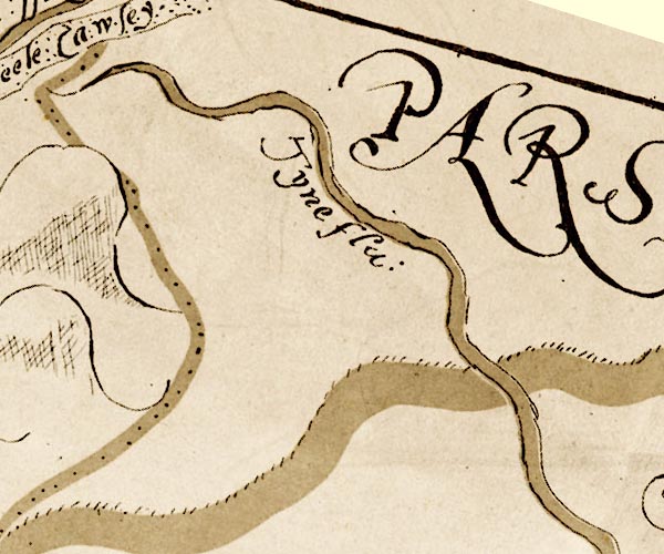
North Tyne, River -- river -- NY8383 (etc etc)
-- 'Tyne flu:' -- river
| |
 M048NY38.jpg
 |
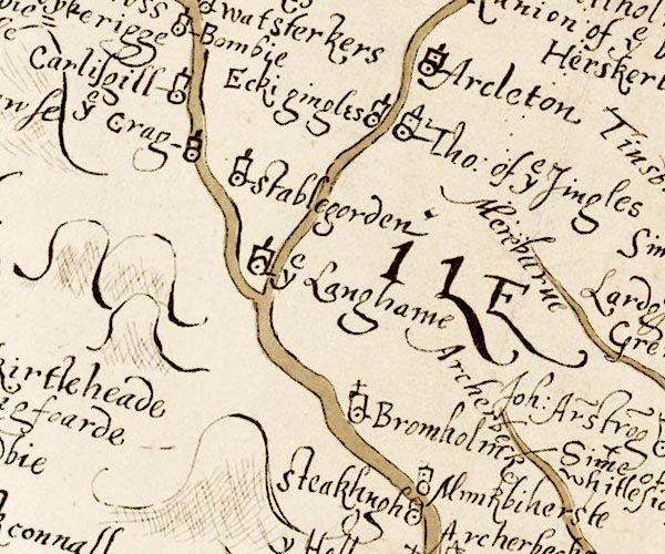
Archer Beck -- river -- NY4178 (etc)
-- 'Archer beck' -- river
Broomholm -- building/s -- NY3781 -- 'Bromholm' -- circle, tower, cross Langholm -- building/s -- NY364848 -- 'ye Langhame' -- circle, tower Muir Burn -- river -- NY4581 (etc) -- 'Mereburne' -- river Nether Mumbie -- building/s -- NY379797 -- 'M[un]kbiherste' -- circle, tower probably | |
 M048NY48.jpg
 |
Greena Tower -- tower (site) -- NY46168076
-- 'Grenehag' -- circle, tower
Hartsgarth -- building/s -- NY494926 -- 'Herskerth' -- circle, tower, cross Kershopefoot -- building/s -- NY475829 (?) ? -- 'kirsopfoote' -- circle, tower Laird Jocks, Scotland -- locality -- NY4783 (guess) -- 'Lard[g] Jockes' -- circle, tower Mangerton Tower -- building/s (remains) -- NY479853 -- 'Mangerton' -- circle, tower Muirburnhead -- building/s (site) -- NY44468180 -- 'Joh. Ar~stro~g' -- circle, tower perhaps Newcastleton -- building/s -- NY483875 (etc) -- 'Copshaws' -- circle, tower Old Castleton -- building/s -- NY51309007 -- 'Castelton' -- circle, tower, cross Pouterlampert -- building/s (site) -- NY513884 (about) -- 'Potterlamport' -- circle, tower, cross Sims Thoms, Scotland -- locality -- NY4785 (guess) -- 'Sims Thoms' -- circle, tower Stonegarthside Hall -- building/s -- NY48038186 ? -- 'Ro. forsters' -- circle, tower probably Tinnis Burn -- river -- NY4683 (etc) -- 'Tinsburne' -- river Whithaugh -- building's -- locality -- NY489880 -- 'whithaugh' -- circle, tower | |
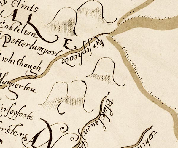 M048NY58.jpg
 |
Black Lyne -- river -- NY5075
-- 'Blak. leven flu.' -- river
Kershopehead -- building/s -- NY544863 -- 'kirsopheade' -- written along the Kershope Burn | |
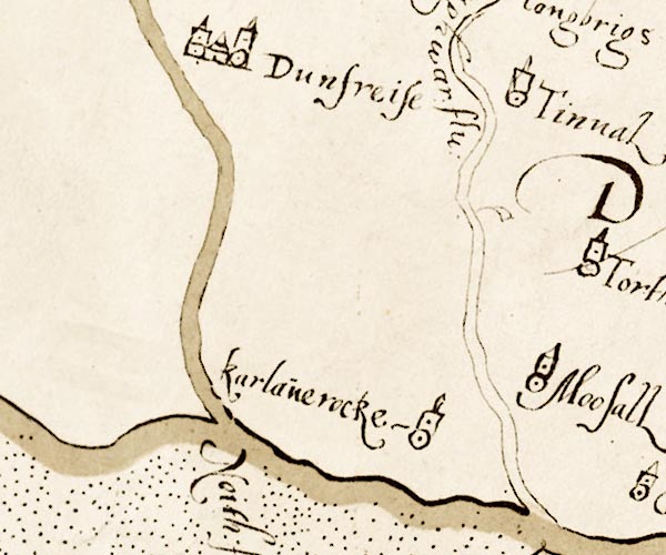 M048NY07.jpg
 |
Dumfries -- building/s -- NX9675
-- 'Dunfreise' -- circle, 2 or 3 towers
Nith, River -- river -- NX9675 (etc) -- 'Neith flu' -- river | |
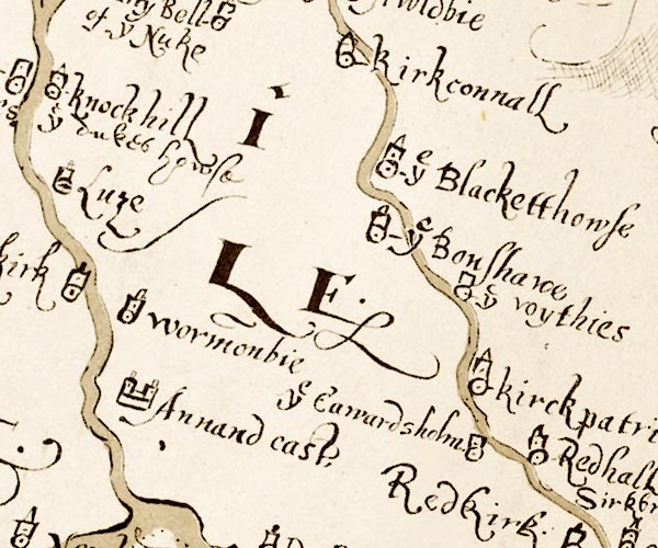 M048NY27.jpg
 |
Annan Castle -- castle -- NY192666
-- 'Annand cast.' -- walls, two towers
Calvertsholm -- locality -- NY282690 -- 'ye Eawardsholm' -- circle, tower Kirkpatrick-Fleming -- building/s -- NY2770 -- 'Kirckpatrik' -- circle, tower | |
 M048NY37.jpg
 |
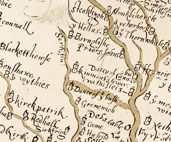
Barnglies -- building/s -- NY328776
-- 'Barnglishe' -- circle, tower
Canonbie -- building/s -- NY392764Canonbie -- building/s -- NY392764 -- 'Davy of Cano~bu' -- W of the Esk Coom -- building/s (site) -- NY337723 (roughly) -- 'Coome' -- circle, tower, cross; marked E of Sark Davie of the Bush, Kirkandrews -- locality -- NY3672 (guess) -- 'Davie of ye bush' -- circle, tower Debatable Land -- area -- NY37 -- 'Debatable Lande' Greenwrae -- building/s -- NY32647294 -- 'Grenewich' -- circle, tower possibly Hollows -- building/s -- NY383782 -- 'y Hollas' -- circle, tower Priorslynn -- building/s -- NY394759 -- 'Priors Johns' -- circle, tower, cross probably Redhall -- building/s -- NY28966938 -- 'Redhall' -- circle, tower Steakhugh (?) -- locality -- NY372804 (?) -- 'Steakhugh' -- circle, tower Tower of Sark -- building/s -- tower -- NY334750 -- 'Kinmonts tower' -- circle, tower Woodhouselees -- building/s -- NY394749 -- 'withisleis' -- circle, tower probably | |
 M048NY47.jpg
 |
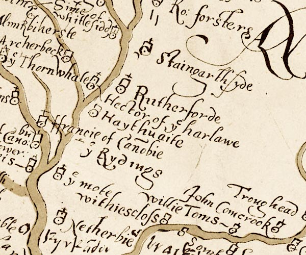
Archerbeck -- building/s -- locality -- NY41627792
-- 'Archerbeck' -- circle, tower
Canonbie -- building/s -- NY392764Canonbie -- building/s -- NY392764 -- 'ffrancie of Cano~bie' -- circle, tower, cross Cumcrook -- building/s -- NY50317499Cumcrook -- building/s -- NY50317499 -- 'John Comcrook' -- circle, tower; across the river from Cumcrook possibly Haithwaite -- building/s -- NY443773 ? -- 'Haythuaite' -- circle, tower Harelaw -- building/s -- NY4378 -- 'Hector of ye harlawe' -- circle, tower, cross Highmoat -- building/s -- NY39687372 -- 'ye mote' -- circle, tower, cross Netherby -- building/s -- park -- NY39667161 -- 'Netherbie' -- circle, tower, cross Riddings -- building/s -- NY407750 -- 'ye Rydings' -- circle, tower Rutherford (?) -- locality -- NY4478 (guess) -- 'Rutherforde' -- circle, tower, cross Stonegarthside -- locality -- NY480817 (?) -- 'Staingarthsyde' -- circle, tower, cross Thorniewhats -- building/s -- NY389784 -- 'ye Thornwhale' -- circle, tower Whiteclose -- building/s -- NY467709 -- 'withiescloss' -- circle, tower Whitlawside -- building/s -- NY44468005 -- 'Sime of whitlesid[ ]' -- circle, tower Willie Toms, Solport -- locality -- NY4975 -- 'Willie Toms' -- circle, tower | |
 M048NY57.jpg
 |
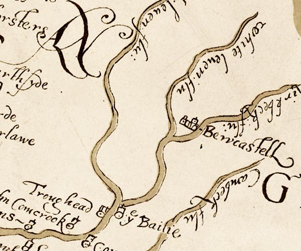
Bailey -- locality -- NY5179
-- 'ye Bailie' -- circle, tower, cross
Bew Castle -- castle -- NY56567468 -- 'Bewcastell' -- circle, buildings or walls, tower Cam Beck -- river -- NY5469 (etc) -- 'Cambeck flu' -- river Trough Head -- building/s -- NY479751 -- 'Troughead' -- circle, tower White Lyne -- river -- NY4973 (etc) -- 'white leven flu' -- river | |
 M048NY67.jpg
 |
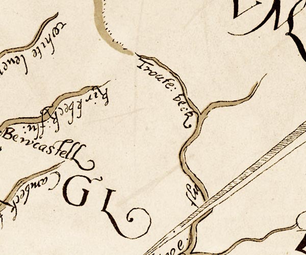
Gair Burn -- river -- boundary -- NY6278 (etc) ?
-- 'Troute beck' -- river
Kirk Beck -- river -- NY5774 (etc) -- 'kirkbeck flu' -- river | |
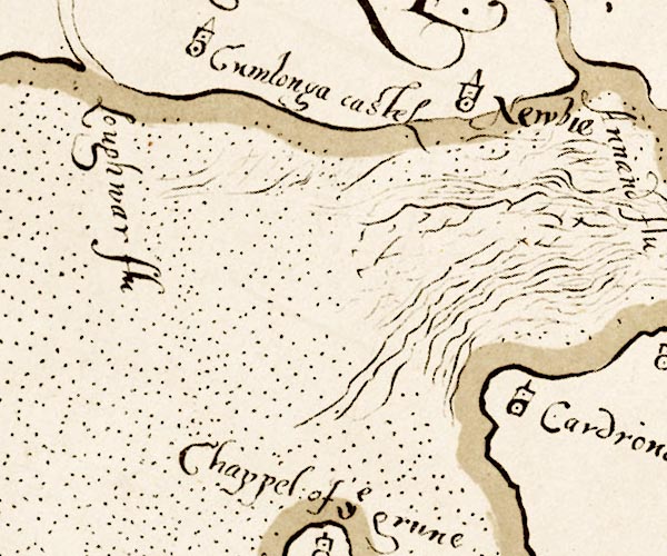 M048NY16.jpg
 |
Comlongon Castle -- castle -- NY0769
-- 'Cumlonga castel' -- circle, tower
Lochar Water -- river -- NY0566 -- 'Loughwar flu' -- river Newbie Mains -- building/s -- NY173646 -- 'Newbie' -- circle, tower | |
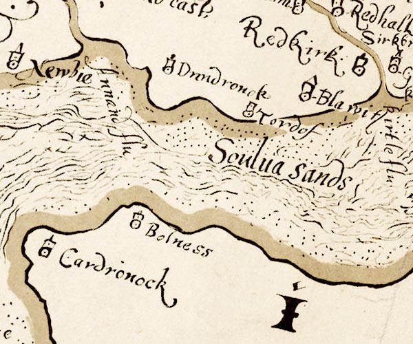 M048NY26.jpg
 |
Annan, River -- river -- NY1865 (etc)
-- 'Annand flu' -- river
Blaatwood -- building/s (site) -- NY279660 (about) -- 'Blawit' -- circle, tower perhaps Bowness-on-Solway -- building/s -- NY224628 -- 'Bolness' -- circle, tower Cardurnock -- building/s -- locality -- NY1758 -- 'Cardronock' -- circle, tower Dornock -- building/s -- NY231660 -- 'Dundronok' -- circle, tower Solway Firth -- estuary -- river estuary -- sea area -- NY16 (etc) ? -- 'Soulua Sands' -- wavy lines Torduff -- locality -- NY257646 -- 'Tordof' -- circle, tower | |
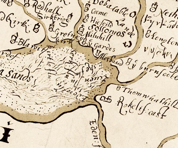 M048NY36.jpg
 |
Burnfoot -- building/s -- NY3666
-- 'ye burnfoote' -- circle, tower
Esk, River -- river -- boundary -- county boundary etc -- NY3666 (etc) -- 'Eske flu.' -- river Gretna Green -- building/s -- NY319680 -- 'Gretney kirk' -- circle, tower Guards Farm -- building/s -- NY33196674 -- 'ye Gardes' -- circle, tower Kirtle Water -- river -- NY2968 (etc etc) -- 'kirtle flu' -- river Lyne, River -- river etc -- NY3765 (etc) -- 'Leven flu' -- river Mill Hill -- building/s -- NY340679 -- 'Milnhill' -- circle, tower, cross Moss Side -- building/s -- NY343708 -- 'Hiefeild' -- circle, tower perhaps Mossbandhall -- building/s -- NY34406547 -- 'Mosband' -- circle, tower Redkirk -- building/s -- NY300659 -- 'Redkirk' -- circle, tower Rockcliffe Castle -- castle (site) -- NY35356194 (?) -- 'Rokelif. cast' -- perhaps circle, tower Rosetrees -- building/s (gone) -- NY355667 -- '[rosetere]' -- marked by a dot in brackets Sark, River -- river -- boundary -- national boundary -- county boundary -- NY3372 (etc) -- 'Serk flu.' -- river Sarkbridge -- building/s -- NY32266686 -- 'Sirkbrig' -- circle, tower Solway Moss -- moss -- peat moss -- NY3469 (etc) -- 'Sollomos' -- Todhills -- building/s -- NY3663 ? -- 'Thomwhathill' -- circle, tower | |
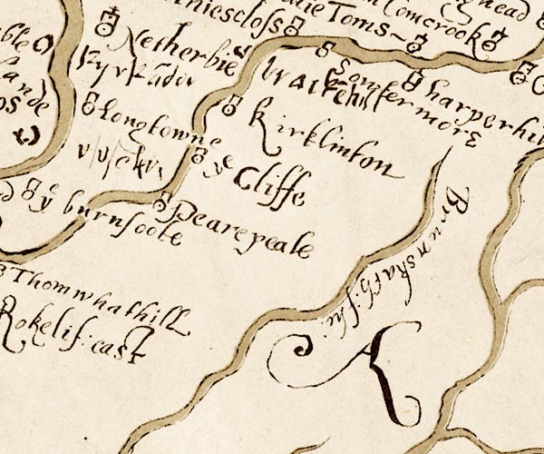 M048NY46.jpg
 |
Brackenhill Tower -- tower -- NY445694 ? ?
-- 'bracke~hill' -- symbol not clear
Brunstock Beck -- river -- NY4261 -- 'Brunskath flu' -- river Cliff -- locality -- NY4166 -- 'ye Cliffe' -- circle, tower Harperhill -- building/s -- NY501716 -- 'harperhill' -- circle, tower Kirkandrews Tower -- building/s -- NY38877190 -- 'Kyrka~der' -- circle Kirklinton -- building/s -- NY432670 -- 'kirklinton' -- circle, tower Longtown -- building/s etc -- NY381686 -- 'Longtowne' -- circle, tower Pearepeal, Kirklinton Middle -- locality -- NY4065 (guess) -- 'Pearepeale' -- circle, tower Soutermoor -- building/s -- NY48817111 -- 'Sowtermore' -- circle, tower | |
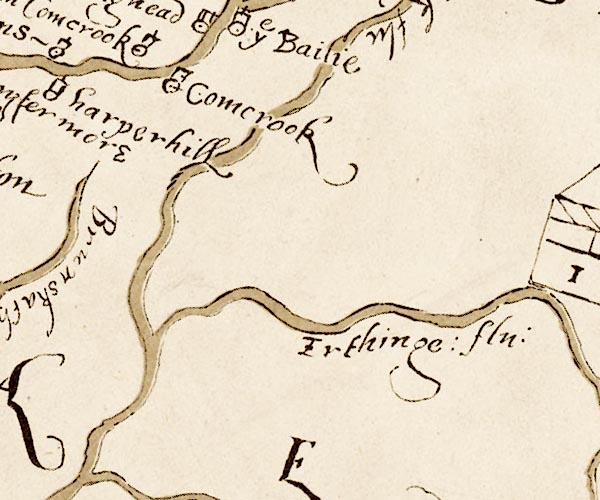 M048NY56.jpg
 |
Cumcrook -- building/s -- NY50317499Cumcrook --
building/s -- NY50317499
-- 'Comcrook' -- circle, tower possibly
Irthing, River -- river -- boundary -- county boundary -- NY4758 (etc etc) -- 'Irthinge flu' -- river | |
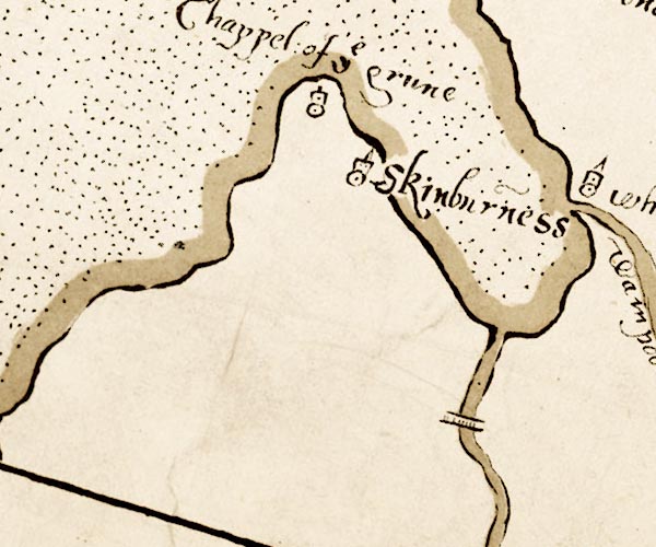 M048NY15.jpg
 |
Chapel of the Grune -- chapel (gone) -- church (gone) --
NY13605644 (approx)
-- 'Chappel of ye grune' -- circle, tower
New Bridge -- bridge -- NY18385143 -- '' -- bridge over the Waver Skinburness -- building/s etc -- NY125560 -- 'Skinburness' -- circle, tower Waver, River -- river etc -- NY1751 (etc) -- '' -- river | |
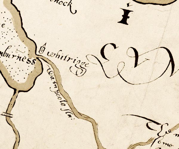 M048NY25.jpg
 |
Wampool, River -- river etc -- NY1757 (etc) ?
-- 'Wampoole flu.' -- river
Whitrigg -- building/s -- NY2257 -- 'whitrigge' -- circle, tower | |
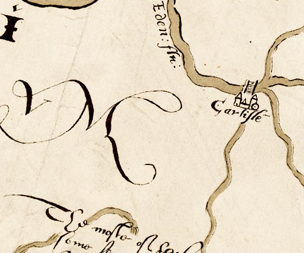 M048NY35.jpg
 |
Carlisle -- building/s etc -- NY403558
-- 'Carlisle' -- circle, buildings or walls, two towers
Eden Bridge -- bridge -- NY40075656 -- '' -- bridge over the Eden at Carlisle Eden, River -- river -- NY3658 (etc) -- 'Eden flu' -- river | |
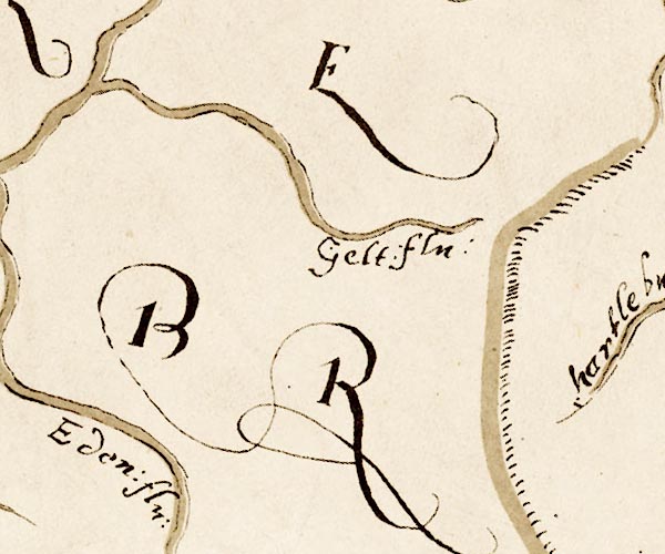 M048NY55.jpg
 |
Gelt, River -- river -- NY5456 (etc) ?
-- 'Gelt flu' -- river
| |
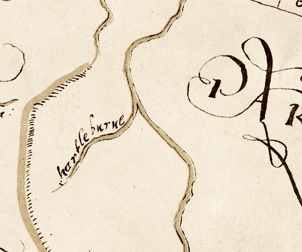 M048NY65.jpg
 |
Hartley Burn -- river -- NY6760
-- 'hartleburne' -- river
| |
 M048NY24.jpg
 |
bridge, Woodside -- bridge -- NY279499
-- '' -- bridge over the Wampool
| |
 M048NY64.jpg
 |
South Tyne, River -- river etc -- NY7441 (etc) ?
-- 'S. Tyne flu.' -- river
| |
 Lakes Guides menu.