 Debatable Land

|

|
|
|
|
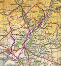
Debatable Land An area on the England Scotland border between Esk and Sark was for a long while in neither one kingdom or the other; which river was the border? It was threap, disputed, land lying in the West March, about 4 miles wide and 12 miles long, called the Debatable Land perhaps from the 15th century. Neither kingdom would admit the other had responsibilty there, and so could not hold the other responsible for what went on in the area. The land was no-mans land, home to rogues; Lord Wharton described it as a most strong ground for offenders to be relieved inAlthough it was cleaned out now and then it was the home of several families of border raiders, amongst whom, the Armstrongs and the Grahams. When the wars between England and Scotland in the 1540s, the Rough Wooing, were ended, the Treaty of Norham signed, it was thought to resolve this problem area. The English suggested they should take it all. The Scots proposed a division so that ilk realme might ken their awin part and puniss the inhabitants thereofAs a preliminary it was agreed to clear out the area once more. Lord Maxwell, the scottish march warden, devastated it in 1551, leaving not one building standing. In 1552 commissioners met to divide the land in two: Douglas of Drumlanrigg leading the Scots; Lord Wharton leading the English; the french ambassador acting umpire. The new frontier was a trench dug from Esk to Sark, with stones set up bearing the arms of England and of Scotland. It didn't stop the raiding, but the march wardens each now knew where their writ ran. |
|||
|
Ridpath |
|||
|
George Ridpath comments on the Debatable Land,
p.573:-
Early in the following year [1552], it was agreed between the court of England and the French ambassador residing there, that an effectual remedy should be applied to a perpetual source of contention between the English and Scots; which arose from a small tract of ground, commonly called the Debatable land†, situated between the rivers Esk and Sark, on the extremity of the western border. As no authority was exercised in that tract by the kings of either nation, it naturally became a place of refuge for the most abandoned criminals after their expulsion or flight from their own country. From thence they made their plundering inroads into the countries adjacent on either side, and thither they retired with their booty; and often by fear or favour induced the neighbouring inhabitants to be partakers of their crimes. It was first proposed, that, agreeably to an article in the treaty of Norham, that district should be wholly evacuated and laid waste; but it was afterwards thought better to make a division of it between the kingdoms. For this purpose, after some scruples and delays, commissioners appointed by each of the powers, met on the spot, and agreed on a line to be marked by a ditch and marchstones; the ground of one side thenceforth to belong to England, and that on the other to Scotland ‡. † Terra contentiosa. ‡ The ratification of this division was given by the governor of Scotland at Jedburgh, Nov. 9. |
|||
|
William Camden, and Richard Gough |
|||
|
The Debatable Land is described in the 1789 edition of
Camden's Britannia. This is in Gough's 'Additions' and is
referenced to Burn, p.xvi:-
Page 199:- ... The Debateable ground was a tract of land claimed by both kingdoms, which was the occasion of infinite troubles and vexations. The boundary of it in an old roll is thus described: "Beginning at the foot of the White Scyrke running into the sea, and so up the said water of Scyrke till it come to a place called Pyngilburne foot running into the said water of Scyrke and up the Pyngilburne till it come to Pyngilburne Know, from thence to the Righeads, from the Righeads to the Monke Rilande Burne, and from thence down to Har- Page 200:- "[Har]venburne till it fall in Eske and through Eske to the foot of Terras, and go up Terras to the foot of Reygill and up the Reygill to the Tophous and so to the standing stone and to the Mearburne head, and down Mearburne to it fall in Lyddal at the Rutterford, and down Lyddal to it fall in Eske and down Eske to it fall into the sea." It was in length eight computed miles of the country and in breadth four miles. ... Identifying the way points in this description is not always easy. |
|||
|
White Scyrke;
Scyrke |
River Sark
Sark foot - NY32426631 about the end of the more recent Scots Dike - NY33257402 Sark Bridge - NY33257526 junction with the Pingle Sike - NY32307769 It is not clear where the Pingle ends and the Sark begins. The Black Sark is a tributary to the Sark at NY333692; Blaeu calls the Sark the White Sark. |
||
| Pyngilburne |
Pingle Sike
foot, into the Sark - NY32307769 runs towards - NY31967896 |
||
| Pyngilburne Knowe |
unidentified
|
||
| Righeads |
unidentified
|
||
| Monke Riland Burne |
unidentified
|
||
| Harvenburne |
Irvine Burn
runs from - NY35118217, through NY35227981 foot of burn, into the Esk - NY37408035 The boundary is possibly just the latter stretch of river. |
||
| Terras |
Tarras Water
Tarrasfoot, into the Esk - NY37528070 |
||
| Reygill |
Raegill Burn
foot of Raegill, into the Tarras - NY39208272 head of Raegill about - NY411842 |
||
| Tophus |
uncertain, probably
The Haunches - NY4285, on the side of Tinnis Hill |
||
| standing stone |
standing stones
at - NY43048387 |
||
| Meaburnehead |
Muirburnhead
about - NY450823 |
||
| Meaburn |
Muir Burn
foot of the Muir Burn, into the Liddel - NY45327966 |
||
| Rutterford |
Ruterford on Blaeu's map of Lidisdail
about - NY449795 |
||
| Lyddal |
Liddel Water
foot of Liddel, into the Esk - NY39447386 |
||
| Eske |
Esk, River
bend near Liddel Strength - NY402743 - notice the mismatch of the current national boundary and the present river course, the river has moved end of Scots Dike - NY38847316 by Sarkfoot Point - NY32456595 |
||
These identifications are made with the limited resources
of our own library: modern 1:25000 maps; OS County Series
sheets; reproduction of Blaeu's atlas; etc etc.
 |
|||
|
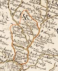
Burghley 1590 Lord Burghley had a Plott of the Opposete Border of Scotland to ye West Marches of England, on which we have drawn the likely boundary of the Debatable Land:-
 |
|||
|
Clarke 1787 There is a briefer description of the extent of the Debatable Land in James Clarke's description of the Lakes, 1787:- Preface page x:- ... There still remains to mention another trifle, which was a nursery to the disorders, and an inexhaustible source of contention: this was the debateable ground; of which I shall relate nothing but what the order for its settlement in the days of Edward VI. authorises. Its length could not exceed 5 miles, extending from Esk to Sark at Dimmisdale Syke-foot, and thence to Kirk-ling: yet this was only the boundary of the kingdoms then made; for the real boundary was never known before, with certainty, in this piece of ground, on account of the immemorial disorders which had prevailed there, and even the antiquity of its being debateable was too remote for the longest-lived tradition. It is said that this trifling piece of ground, from the most striking circumstances, had given birth to prodigious, and, if we respect the causes, astonishing commotions between the two kingdoms; being the sink and receptacle of proscribed wretches, who acknowledged neither King, obeyed the laws of neither country, and feared no punishment: ... |
|||
|
References Camden, William & Gough, Richard (ed): 1789: Britannia: (London) Clarke, James: 1787: Survey of the Lakes of Cumberland, Westmorland and Lancashire: (Penrith, Cumberland, and London) Fraser, George MacDonald: 1971: Steel Bonnets; the story of the Anglo-Scottish Border Reivers: Barrie and Jenkins:: ISBN 0 00 217261 5 |
|||
|
|
|||
 Lakes Guides menu.