

 next page
Further adverts appear at the end of the book.


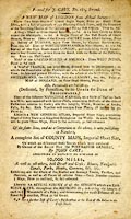
Printed for J. CARY, No. 181, Strand.
Including:-
A NEW MAP of LONDON ...
... Survey of DURHAM, upon Four Sheets, by Captain ARMSTRONG ... Ditto of NORTHUMBERLAND, in Nine Sheets ...
Survey of the High Roads of LONDON ...
MAP of the UNITED STATES of AMERICA: Ditto WEST INDIES ...
A MAP of FRANCE ... with the whole of the NETHERLANDS, SWITZERLAND, and GRISSONS, Part of GERMANY, &c. ...
MAP of HOLLAND ...
Plans of the different NAVIGABLE CANALS, on a Scale of Half an Inch to a Mile ...
... a NEW GENERAL ATLAS ...
A complete Set of COUNTY MAPS ...
... An Actual Survey of all the STREETS which are CARRIAGE WAYS, throughout the METROPOLIS ...

 Cary's New Itinerary 1802,
advertisements