| source data:- |
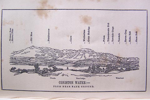
Print, engraving, outline view of mountains, Coniston Water from near Bank Ground,
drawn by Mr Binns, Halifax, engraved by Mr Jewitt, Headington, Oxfordshire, published
by Jonathan Otley, Keswick, Cumberland et al, 1849.
 click to enlarge click to enlarge
O80E05.jpg
Opposite p.8 of A Descriptive Guide of the English Lakes, by Jonathan Otley, 8th edition,
1849.
printed at bottom:- "CONISTON WATER: - / FROM NEAR BANK GROUND."
printed at top:- "Walney Scar / Brown Pike / Old Man / Buckbarrow / Carrs / Wetherlam / Great Oukrigg
/ Prism / Tilberthwaite Fell / Yewdale Crags / Yewdale / Raven Crag / Holm Fell /
Oxen Fell"
printed at bottom:- "Church. Tent Lodge. Waterhead."
Looking NW; 100 degree view, WbyS to N.
item:- Armitt Library : A1180.6
Image © see bottom of page
|
 Lakes Guides menu.
