 Wallis 1812

|

|
|

|
back to object record | |
| Map Features | ||
|
|
||
|
title
plain cartouche map maker publisher |
Printed in a plain title cartouche, lower right:-
WESTMORELAND Engrav'd by J. Wallis. Printed at the bottom:- London, Publish'd by S. A. Oddy, 1812. |
|
|
|
||
| table of symbols |
Printed lower left is an:-
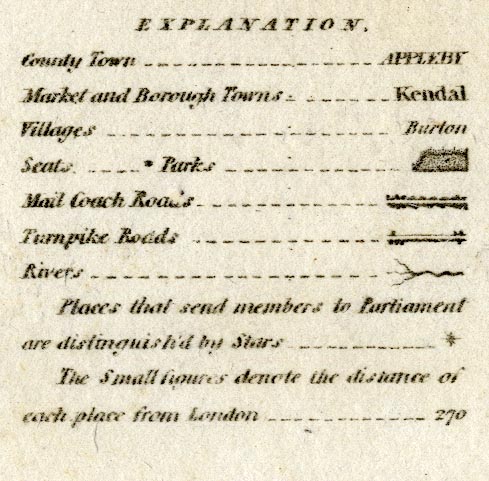
EXPLANATION County Town ... APPLEBY [italic block caps] Market and Borough Towns ... Kendal [upright lowercase] Villages ... Barton [italic lowercase] Seats ... [block] Parks ... [outline of fence palings, pecked interior] Mail Coach Roads ... [double line with dots on both sides] Turnpike Roads ... [double line, light bold, blocks for villages] Rivers ... [tapering wiggly lines] Places that send members to Parliament are distinguished by Stars ... [star] The Small figures denote the distance of each place from London ... 270 |
|
|
|
||
|
orientation
compass rose up is N |
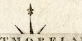
Printed under the title cartouche lower right is a compass rose; no circle, star points for cardinal and half cardinal directions, North marked by a fleur de lys spear point. The map is printed with North at the top of the sheet. |
|
|
|
||
|
scale line
scale |
Printed upper right is a:-
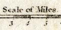
Scale of Miles chequered and labelled in miles. The 8 miles = 33.4 mm gives a scale 1 to 385472. The map scale is about:- 1 to 390000 6 miles to 1 inch |
|
|
|
||
| lat and long scales |
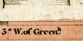
Printed in the map borders are scales of latitude and longitude for a rectangular projection; chequered and labelled at 10 minutes intervals of longitude, 5 minute intervals of latitude. The bottom longitude scale is labelled:- W. of Greenh. Reading from the scales the longitude, Kendal = 2d 44m W approximately. This agrees pretty well with the true figure 2d 44.8m W. The map includes from 1d 49m to 3d 32m W, from 53d 55m to 54d18m N; all of Westmorland and some space around. |
|
|
|
||
|
sea area
sea plain |
A tiny area of sea, in the Kent Estuary, is plain.
|
|
|
|
||
|
coast line
coast shaded |
The coast line in the Kent Estuary is shaded for emphasis. |
|
|
|
||
|
rivers
bridges |
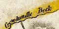
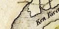
Rivers are drawn by a wiggly line tapering upstream. Some rivers are labelled, eg:- Ken River Eden R. Crowdundle Beck Winster Water A waterfall might be labelled, eg:- 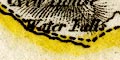
Water Falls on the southern boundary near Rother Bridge. and:- C[al ]en Snout on the border with Durham and Yorkshire. Bridges are not particularly marked but are implied where a road crosses and interrupts a stream. Few are labelled, but see:- Bowley Br. [Pooley Bridge] Rother Br. [Rawthey Bridge] |
|
|
|
||
| lakes |
Lakes are drawn in outline with the shore line shaded. Some lakes are labelled:- Broader Water [Brothers Water] Elter Water Grasmere Water Hays Water Skeggles Water Ulles Water Winander Mere Other lakes might be recognized, eg:- Angle Tarn, Martindale Cow Green Reservoir [now] decoy pond, Lowther (?) Easedale Tarn Hawes Water Loughrigg Tarn Rydal Water Sunbiggin Tarn |
|
|
|
||
| forests |
Woodland is not indicated but a forest might be labelled,
eg:-
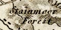
Stainmoor Forest Lune Forest |
|
|
|
||
|
relief
hill hachuring |
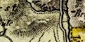
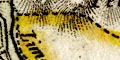
Some relief is indicated by hill hachuring, shaded to the east. With a bit of imagination the overall shape of the hills of the central Lakes, and the Pennines, can be seen, and the Eden Valley and low parts of the south of the county. Some hills are labelled, eg:- Helvelyn Loughrigg Fell Dow Crags [border with Yorkshire] Round Hill [border with Yorkshire] A valley might be labelled, eg:- Borrowdale [up from Low Borrow Bridge] |
|
|
|
||
| parks |
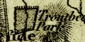
Parks are drawn by an outline of fence palings, the interior pecked. They might be labelled, eg:- Killington Park or attached to a great house, eg:- Rydal Hall |
|
|
|
||
| county |
The county boundary is a dotted line, emphasised by tints on the outside. The colours have faded, no longer clearly distinguishing the adjacent counties. The boundary line is not continued alongside a boundary feature. It is not clear what part of Windermere is included in the county. Ullswater is divided much as it was later. Adjacent counties are labelled, eg:- LANCASHIRE DURHAM A number of features are drawn on the county boundary. Notice particularly the:- 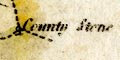
County Stone at the boundary of Lancashire, Yorkshire and Westmorland. Little is shown outwith the county except Sedbergh and the road from Kirkby Lonsdale to Kirkby Stephen, and Penrith on the road north. |
|
|
|
||
|
wards
table of wards |
Ward boundaries are a fine dotted line. The four wards areas should be labelled by numbers referring to a table of wards printed upper left;- WARDS. 1 East Ward 2 West Ward 3 Kendale ... 4 Lonsdale ... but I haven't found the numbers yet. The four areas are tinted, the colours faded. |
|
|
|
||
| settlements |
Settlements are marked by blocks, differentiated by style
of labelling.
|
|
|
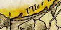
towns
distances from London electoral data |
blocks, perhaps on a minimal street plan; labelled in
upright lowercase text, eg:-
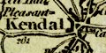
Kendal / 262 Ambleside / 275 The de jure county town is labelled in italic block caps:- 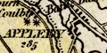
APPLEBY / 285 and has two stars attached for the members it sends to Parliament. Towns are listed, see:- |
|
|
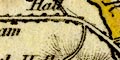
villages
hamlets |
block or blocks or a circle and tower; labelled in italic
lowercase text, eg:-
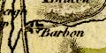
Barbon [blocks] Natland [blocks] 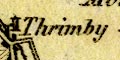
Thrimby [circle, tower] A chapel might be labelled by a circle, and might be labelled:- Chapel [nr Burneside] |
|
| castles |
A castle might be marked by a double circle, labelled,
eg:-
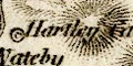
Hartley Castle Maiden Castle Castle [by Brough]*COMMENT3 or just labelled, eg:- Pendragon Cas. |
|
| houses |
As explained on the table of symbols 'seats' are marked
by a block, and might be labelled, eg:-
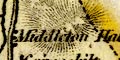
Middleton Hall |
|
|
|
||
| roads |
A network of roads is drawn by double lines. More
important roads are distinguished as explained in the table
of symbols:-
Mail Coach Roads ... [double line with dots on both sides] 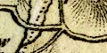
Turnpike Roads ... [double line, light bold] The destination of roads at the county boundary is given for many roads, eg:- fr. Egremont fr. Keswick to Richmond The road near Bowland Bridge labelled:- to Kendal is not so helpful. |
|
|
|
||
| miscellaneous | ||
|
|
||
| stones |
On the border, on the road from Ambleside towards Keswick
is:-
Dunmel raise Stones An array of nine blocks is labelled:- 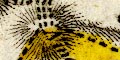
Nine Standards On the east side of the Mallerstang valley is:- Ladys Pillar |
|
|
|
||
|
religious houses
abbeys |
Some abbeys are marked by a patriarchal cross,
labelled:-
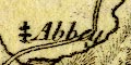
Abbey [N end of Hawes Water] or unlabelled, for example by the road where Shap should be shown. |
|
|
|
||
| beacons |
Some beacons are marked by a tower, labelled, eg:-
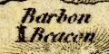
Barbon Beacon |
|
|
|
||
|
mines
coal mines |
Labelled on the south of Stainmoor is:-
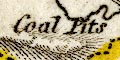
Coal Pits |
|
Lakes Guides menu.