 Westmerland

|

|
|
|
map type:- Simons 1635 |
|
|
|
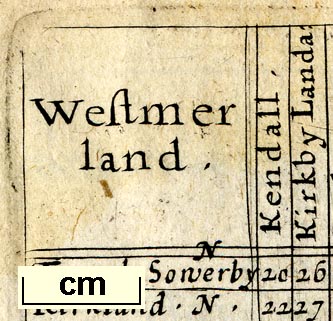
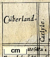
Table of distances and map of Westmerland, scale about 45
miles to 1 inch, and of Cumberland, scale about 41 miles to
1 inch, engraved by Jacob van Langeren, published by Mathew
Simmons, London, 1635-36.
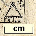
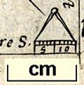
Published in 'A DIRECTION FOR the English TRAVILLER. By which he Shal be inabled to Coast about all England and Wales. And also to know how farre any Market or noteable Towne in any Shire lyeth one from an other, and Whether the same be East, West, North, or South from ye Shire Towne As also the distance betweene London and any other Shire or great towne: with the scituation thereof East, West, North, or South from London. By the help also of this worke one may know (in What Parish, Village, or Mansion house soeuer he be in) What Shires, he is to passe thorough & which way he is to trauell, till he come to his Journies End. Infelix cuius nullis Sapientia prodest. Are to be Sold by Mathew Sim~ons at the Golden Lion in Ducke laine, Ao 1635. Jacob van Langeren sculp.' 1635. The map has only initial letters to label towns. There is a frontispiece which includes a circular map of England and Wales engraved by Kip, preface 'To the gentle Reader', a note on 'The use of all the insueing Tables', plates which have a triangular table of distances, copied from Norden's of 1625, and a thumbnail map about 1 1/4 x 1 1/4 ins, plain reverse; the map derives from the playing card maps of 1590; book size is 4 1/4 x 4 3/8 ins. Published in an edition 1636. Published by John Garrett, at the south entrance of the Royal Exchange, London, 1650. In the 1636 edition the table has a line of figures added along the diagonal of the table; the distance of each town from London. There is an introductory table of stages of the principal main roads in England and Wales whose stages match those in 16th century tables, eg the Chronicle of Yeres, 1541. Published in an altered edition 1643, see Jenner 1643. |
||

|
Jenner 1643 | |
|
||
|
||
| references:- |
Simmons, Mathew: 1635: Direction for the English Traviller:
(London) Fordham, H G, Sir: 1924: Roadbooks and Itineraries of Great Britain, 1570-1850: (Cambridge) Box, E G: 1931: Hampshire in Early Maps and Road Books; ProcHFC: 12: pp.221-35 Keuning, J: 1956: Van Langeren Family, The: Imago Mundi: 13: pp.101-09 |
|
| sources:- |
Chubb 1927 (XLIV) Curwen 1918 Skelton 1970 Box Collection Armitt Library |
|
| items seen (illustrated items in bold):- | ||
|
|
Armitt Library : ALMC2008.14.97 -- table of distances -- Westmerland -- Direction for the English Traviller | |
|
|
private collection (50_11) -- table of distances -- Cumberland -- Direction for the English Traviller | |
|
|
private collection (50_22) -- table of distances -- Lancashire -- Direction for the English Traviller | |
|
|
private collection (50_39) -- table of distances -- Westmerland -- Direction for the English Traviller | |