 England and Wales with the Canals, Navigable Rivers,
Railroads
England and Wales with the Canals, Navigable Rivers,
Railroads

|

|
|
|
map type:- Unknown 1840s |
|
|
|
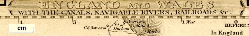
Railway and canal map, England and Wales with the Canals,
Navigable Rivers, Railroads &c, scale about 43 miles to 1
inch, published 1840s?.
The railways shown are - Newcastle and Carlisle Railway, open 1836; Maryport and Carlisle Railway, open 1840-45. The Lancaster Canal is shown. |
||
| map feature:- | plain cartouche & compass rose & up is N & scale line & lat and long scales (trapezoidal projection?) & sea plain & coast form lines & rivers (mostly estuaries only) & county & settlements & railways & canals | |
| inscription:- |
printed shaded cartouche, upper centre
ENGLAND AND WALES / WITH THE CANALS, NAVIGABLE RIVERS, RAILRODS, &c. |
|
| wxh, sheet:- | 21x25.5cm | |
| wxh, map:- | 200x252mm (?) | |
| scale line:- | 70 miles = 41.0 mm | |
| scale:- | 1 to 2700000 ? (1 to 2747660 from scale line) | |
|
||
| sources:- |
JandMN Collection |
|
| items seen (illustrated items in bold):- | ||

|
JandMN (438) -- railway map -- England and Wales with the Canals, Navigable Rivers, Railroads | |
|
|
Skipton Museum : 1 -- handkerchief -- Railways in Great Britain | |