 Unknown 1552

|

|
|
|
map type:- Unknown 1552 |
|
|
|
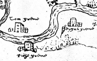
Map, The Debatable Land, Cumberland and Scotland, with
lines of proposed divisions, 1552; published by Cumberland
and Westmorland Antiquarian and Archaeological Society,
Kendal, Westmorland, 1914.
Reproduced with an article about the Debatable Land by T H B Graham. |
||
|
(exmaple private collection (230))
|
||
| inscription:- |
printed alongside a proposed partition
[The English commiss. offer] |
|
| inscription:- |
printed alongside a proposed partition
[The accord wt ye ff. ambassador, linea stellata] |
|
| inscription:- |
printed alongside a proposed partition
[The Scottes offerr] |
|
| inscription:- |
printed alongside a proposed partition
[This is the last and fynal lyne of the parcon concluded xxiiij Septembris 1552] |
|
| wxh, map (reproduction):- | 188x247mm | |
|
||
| references:- |
Graham, T H B: 1914: Debatable Land, The; part 2: Trans
CWAAS: 2nd series vol.14: pp.132-157; opp p.133 |
|
| sources:- |
National Archives (S P Scotland Edw VI vol.5 no.70) private collection |
|
| items seen (illustrated items in bold):- | ||

|
private collection (230) -- map | |