 Archaeological Map of Lancashire

|

|
|
|
map type:- Society of Antiquaries 1896 |
|
|
|
An Archaeological Map of Lancashire, authored by William
Harrison, drawn by Stanford, London, published by the
Society of Antiquaries of London, London, 1896.
Folded and tipped in at the end of An Archaeological Survey of Lancashire, by William Harrison. Drawn on an Ordnance Survey base map. |
||
|
(example private collection (200_1))
|
||
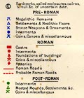
| map feature:- | folded (3x3) & table of symbols & up is N & scale line & lat and long scales & lat and long grid & sea plain & coast form lines & rivers & lakes & parks & county & settlements & roads & canals & railways & archaeology & roman roads & roman forts & | |
| inscription:- |
printed lower left
ARCHAEOLOGICAL MAP OF LANCASHIRE |
|
| inscription:- |
printed bottom left, right
Prepared by permission, from the Ordnance Map. / London. Stanford's Geogl. Estabt. |
|
| wxh, sheet:- | 49.5x64cm | |
| wxh, map:- | 456x564mm | |
| inscription:- |
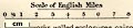
printed with scale line
Scale of English Miles |
|
| scale line:- | 8 miles = 51.1 mm | |
|
||
|
||
| sources:- |
private collection |
|
| items seen (illustrated items in bold):- | ||

|
private collection (200_1) -- map -- Archaeological Map of Lancashire | |