 Map of the Black Lead Mines in Cumberland

|

|
|
|
map type:- Smith 1751 |
|
|
|
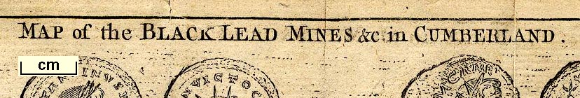
Map of the Black Lead Mines in Cumberland, and area,
scale about 2 miles to 1 inch, by George Smith, published in
the Gentleman's Magazine, 1751.
The map was published in June 1751 to accompany an article by GS, in the issue for February 1751, vol.21 opposite p.51. The map includes Cockermouth, Keswick, Borrowdale etc, south to Seathwaite. |
||
|
(map example Armitt Library : item 1)
|
||
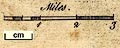
| map feature:- | compass rose (minimal) & up is W & scale line & rivers & lakes & relief & hillocks & woods & trees & settlements & roads | |
| scale line:- | 3 miles = 40.6 mm | |
| scale:- | 1 to 120000 ? (1 to 118917 from scale line) | |
| wxh, sheet:- | 25.5x21cm (approx) | |
| wxh, map:- | 241x196mm | |
|
||
| sources:- |
Armitt Library JandMN Collection Wordsworth Trust Collection Carlisle Library Maps Kendal Library Maps |
|
| items seen (illustrated items in bold):- | ||

|
Armitt Library : Gents Mag 1751.1 -- map -- Map of the Black Lead Mines in Cumberland | |
|
|
Carlisle Library : Map 50 -- map -- Map of the Black Lead Mines in Cumberland | |
|
|
Dove Cottage : Lowther.50 -- map -- Map of the Black Lead Mines in Cumberland | |
|
|
JandMN (114) -- map -- Map of the Black Lead Mines in Cumberland | |
|
|
Kendal Library : Map 133 -- map -- Map of the Black Lead Mines in Cumberland | |