 Seller 1694

|

|
|
|
map type:- Seller 1694 |
|
|
|
Maps, Westmorland, scale about 8 miles to 1 inch, and
Cumberland, scale about 12 miles to 1 inch, by John Seller,
1694, and in an edition of 1787; published 1694-1787.
Published in 'Anglia Contracta. or A Description of the Kingdom of England & Principality of Wales in Several new Mapps of all the Countyes therein Contained By John Seller Hydrographer to The King.' 1694? The atlas has an illustrated title page etc, seven general maps of the country, and pages of text for the whole and for each county; the atlas size is 3 3/4 x 5 7/8 ins. The map is said to be a crude reduction from Speed's map; plain on reverse, not numbered. The map is published unchanged in 1696, 1697, 1701, 1703. Published in 'The History of England. ... With exact Maps of each County, By John Seller, Hydrographer to His Majesty. London, Printed by Job and John How, for John Gwillim, against Crossby-Square, in Bishopgate-street, 1696.' Probably published in 'The History of England ... Together with a particular Description of the Rarities In the several Counties of England and Wales. By John Seller, Hydrographer to His Majesty. London, Printed by Job and John How, and are Sold by H. Newman, at the Grasshopper in the Poultry, 1697.' Published in 'Camden's Britannia Abridgd'd: with Improvements, and Continuations, to this present Time ... The whole Carefully Perform'd, and Illustrated with above Sixty Maps Exactly Engraven. London, Printed by J.B. for Joseph Wild, at the Elephant at Charing Cross. 1701.' The 1701 atlas size is 3 3/4 x 6 3/4 ins. Published in 'The History of England: ... With the Maps of all the Counties and Islands belonging to England, being in all about Seventy Copper Cutts; with a Table of Contents. By John Seller, Hydrographer to Her Majesty. The Third Edition. London: Printed for J. Marshall, at the Bible in Grace-Church street, 1703.' The 1703 atlas size is 3 1/2 x 6 1/4 ins. Published in another edition 'Camden's Britannia Abridgd'd ... London: printed for Isaac Cleave next to Serjeants-Inn in Chancery-Lane. 1711.' Published in 'Supplement To The Antiquities Of England And Wales. ... By Francis Grose, Esqr., F.A.S. London, Printed for S. Hooper, No.212, facing Bloomsbury-Square, High Holborn, 1787.' The map in the 1787 reprint has a new title but is otherwise little changed; Seller's name is gone; the atlas size is 9 x 12 3/4 ins; the map is printed at the top of a page with descriptive text below and on the reverse, describing the county and listing antiquities worthy of notice. The maps are sometimes found in the 4 main volumes rather than in the 2nd supplement, they are peripheral to the work. Published in further editions by S Hooper about 1788, 1789, 1792, and Hooper and Wigstead about 1797. Published in an edition by John Stockdale, 1809. |
||
|
(map example JandMN (7))
|
||
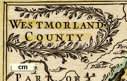
| map feature:- | title cartouche & plain cartouche & labelled borders & up is N & scale line & sea plain & coast shaded & rivers & lakes & relief & hillocks & county & settlements & roads | |
| inscription:- |
printed title cartouche, upper left
WESTMORLAND |
|
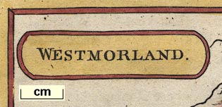
| inscription:- |
printed heading of descriptive text, below map
WESTMORELAND |
|
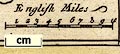
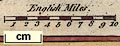
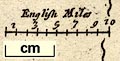
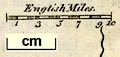
| scale line:- | 10 miles = 30.9 mm | |
| scale:- | 1 to 520000 ? (1 to 520823 from scale line) | |
| wxh, sheet:- | 22x27.5cm | |
| wxh, plate:- | 145x121mm | |
| wxh, map:- | 143x120mm | |
|
||
|
||
|
||
|
||
| references:- |
Seller, John: 1694: Anglia Contracta & Description of the
Kingdom of England and Principality of Wales: (London) Seller, John: 1696: History of England: Gwillim, John (London) Seller, John: 1697: History of England: Newman, H (London) Camden, William & Seller, John (ed): 1701: Camden's Britannia Abridgd'd: Wild, Joseph (London) Seller, John: 1703: History of England ...: Marshall, J (London) Camden, William & Seller, John (ed): 1711: Camden's Britannia Abridgd'd: Cleave, Isaac (London) Grose, Francis: 1787 & 1788 (?) & 1789 (?): Supplement to the Antiquities of England and Wales (2nd supplement) & Antiquities of England and Wales, Supplement to: Hooper, S (London) Grose, Francis: 1797 (?): Supplement to the Antiquities of England and Wales & Antiquities of England and Wales, Supplement to: Hooper, Mary & Wigstead, William (London) Grose, Francis: 1809: Supplement to the Antiquities of England and Wales & Antiquities of England and Wales, Supplement to: Stockdale, John (London) |
|
| sources:- |
Chubb 1927 (CXVIII) Skelton 1970 Hodson 1984 JandMN Collection Wordsworth Trust Collection Armitt Library Carlisle Library Maps Kendal Library Maps |
|
| items seen (illustrated items in bold):- | ||

|
Armitt Library : ALMC2008.14.34 -- map -- Westmorland | |
|
|
Armitt Library : ALMC2008.14.35 -- map -- Westmorland | |
|
|
Armitt Library : ALMC2008.14.36 -- map -- Westmorland | |
|
|
Carlisle Library : Map 18 -- map -- Cumberland | |
|
|
Carlisle Library : Map 19 -- map -- Cumberland | |
|
|
Carlisle Library : Map 63 -- map -- Westmorland | |
|
|
Carlisle Library : Map 64 -- map -- Westmorland | |
|
|
Carlisle Library : Map 138 -- map -- Cumberland | |
|
|
Dove Cottage : 2007.38.87 -- map -- Westmorland | |
|
|
Dove Cottage : 2007.38.88 -- map -- Westmorland | |
|
|
Dove Cottage : 2007.38.89 -- map -- Cumberland | |
|
|
Dove Cottage : 2007.38.90 -- map -- Westmorland | |
|
|
Dove Cottage : 2007.38.91 -- map -- Westmorland | |
|
|
Dove Cottage : 2007.38.92 -- map -- Cumberland | |
|
|
Dove Cottage : 2007.38.98 -- map -- Cumberland | |
|
|
JandMN (7) -- map -- Westmorland | |
|
|
JandMN (111) -- map -- Cumberland | |
|
|
Kendal Library : Map 18 -- map -- Westmorland | |
|
|
Kendal Library : Map 19 -- map -- Westmorland | |
|
|
Kendal Library : Map 46 -- map -- Westmorland | |