 Paterson's British Itinerary

|

|
|
|
map type:- Paterson 1785 |
|
|
|
Road book, Paterson's British Itinerary, road strip maps
and itineraries with sections in Westmorland, Cumberland
etc, scales about 2.5-3 miles to 1 inch, by Capt Daniel
Paterson, London, 1785; published 1785-1807.
Published in 'Paterson's BRITISH ITINERARY Being A new and accurate Delineation and Description of the Direct and Principal Cross ROADS. of Great Britain IN TWO VOLUMES By CAPTN. DANIEL PATERSON, Assistant to the Quarter Master General of HIS MAJESTY'S FORCE. ... L O N D O N printed for and Sold by the Proprietor CARINGTON BOWLES, At his Map and Print-Warehouse, No.69 St. Paul's Church Yard. ... Published as the Act directs, 3 Jan. 1785. The first edition has an overall map 'A New and GENERAL VIEW of the DIRECT ROADS OF ENGLAND & WALES as described in PATERSON'S British Itinerary'. The strip maps are printed on both sides of the paper; each single page has 2 strips of road on one side of the sheet, numbered separately. Volume 1 pagination starts 1and2 on recto, 3and4 on verso, the highest number on the sheet is 4n, for n=1 to ... Volume 2 pagination starts with 1and2 on a verso page, the highest number on a sheet is 4n-2, for n=1 to ...; the strip maps are less basic than earlier strip maps; they are strips out of more normal topographic maps. Roads 'of Lesser Note, OR BRANCHES FROM THE GREATER, Are described in LETTER-PRESS to prevent the swelling of the Work to too great a Size.' The strip maps and text inineraries which describe roads through Westmorland, Cumberland, etc in the 1785 edition are listed below (note that Paterson's page numbering is not strightforward). vol.1 itinerary pp.225-226 - Northern Circuit, Summer Assizes And in vol.2:- maps 33/34, 35/36, 37/38 - from SW, through Greta Bridge, Durham; Brough, Appleby, Westmorland; Penrith, Carlisle, Longtown, Cumberland; Scotland towards Edinburgh maps 67/68, 69/70 - from Kirkby Lonsdale, through Kendal, Ambleside, Westmorland; Keswick, Cockermouth to Whitehaven, Cumberland. maps 99/100, 101/102, 103,104 - from the south, through LancasterCarnforth, Lancashire; Burton, Kendal, Shap, Westmorland; to Penrith, Cumberland. cross roads maps 5/6, 7/8 - from the east, Northumberland; through Brampton, Carlisle, Cockermouth to Workington, Cumberland. itineraries p.145 - Ulverston to Dalton; Ravenglass to Ulverston or to Cartmel and Burton; from Lancaster to Whitehaven; ... itineraries p.146 - Penrith to Holme Abbey; Penrith to Hesket; Kendal to Ireby; Kendal to Brough; Kendal to Appleby; ... itineraries p.147 - Carlisle to Brampton; Penrith to Brampton; ... itineraries p.153 - Askrig to Kirkby Steven; Old INge to sedbergh; Ingleton to Sedbergh; Askrig to Dent; Redmire to sedbergh; ... itineraries p.155 - Aldston or Alston Moor to West Aukland; ... cross roads itineraries p.47 - Carlisle to Cockermouth; ... cross roads itineraries p.48 - Carlisle to Keswick; Carlisle to Holm Abby; Carlisle to Bowness; Carlisle to Allonby; ? to Cockmerouth. cross roads itineraries p.64 - Kendal to Hawkshead; ... cross roads itineraries p.80 - Penrith to Whitehaven by Keswick; and by Ouse Bridge; ... cross roads itineraries p.83 - Richmond to Kendal by Sedbergh; and by Ingleton; ... cross roads itineraries p.94 - Kendal to Ilkley; ... cross roads itineraries p.111 - Berwick to Carlisle; ... cross roads itineraries p.112 - Carlisle to Port Patrick; ... cross roads itineraries p.115 - Glasgow to Carlisle; ... Published in another edition '... Printed for the Proprietors BOWLES & CARVER, London' 1793. There were editions in 1796, 1803, 1807. The maps were copied, re-engraved with differences, for a road book published by Tinsley 1877. |
||

|
Tinsley 1877 | |
| inscription:- |
Printed for the Proprietor CARINGTON BOWLES, London, 3 Jan. 1785. 1785 edition |
|
| inscription:- |
PATERSON'S (VOL. I.) ITINERARY, page headers, vol.1 verso |
|
| inscription:- |
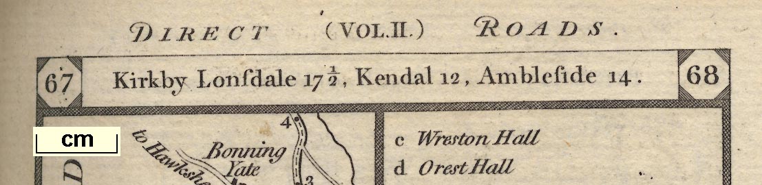
DIRECT (VOL. I.) ROADS. page headers, vol.1 recto |
|
| inscription:- |
PATERSON'S (VOL. II.) ITINERARY, page headers, vol.2 verso |
|
| inscription:- |
CROSS (VOL. II.) ROADS. page headers, vol.2 recto |
|
| inscription:- |
Printed for the Proprietors BOWLES & CARVER, London 1793 edition |
|
| references:- |
Paterson, Daniel: 1785: Paterson's British Itinerary:
Bowles, Carington (London) Paterson, Daniel: 1793: Paterson's British Itinerary: Bowles and Carver (London) |
|
| sources:- |
WILTM Collection private collection HMCMS Map Collection Fordham 1924 Armitt Library |
|
| items seen (illustrated items in bold):- | ||
|
|
Armitt Library : ALMC2008.14.115 -- strip map (pl.99-102) -- London to Carlisle by Coventry and Warrington | |
|
|
Armitt Library : ALMC2008.14.116 -- strip map (pl.67-70) -- Kirkby Lonsdale to Whitehaven | |
|
|
Hampshire Museums : FA2000.36 -- descriptive text -- Paterson's British Itinerary | |
|
|
private collection (19) -- road map -- Paterson's British Itinerary | |
|
|
private collection (19_0) -- road map -- Direct Roads of England and Wales | |
|
|
private collection (19_33) -- strip map (pl.33/34) -- London to Edinburgh by Carlisle | |
|
|
private collection (19_35) -- strip map (pl.35/36) -- London to Edinburgh by Carlisle | |
|
|
private collection (19_37) -- strip map (pl.37/38) -- London to Edinburgh by Carlisle | |
|
|
private collection (19_67) -- strip map (pl.67/68) -- London to Skipton etc, continued to Kendal etc | |
|
|
private collection (19_69) -- strip map (pl.69/70) -- London to Skipton etc, continued to Kendal etc | |
|
|
private collection (19_99) -- strip map (pl.99/100) -- London to Carlisle by Coventry and Warrington | |
|
|
private collection (19_101) -- strip map (pl.101/102) -- London to Carlisle by Coventry and Warrington | |
|
|
private collection (19_103) -- strip map (pl.103/104) -- London to Carlisle by Coventry and Warrington -- London to ... Manchester etc | |
|
|
private collection (19_C5) -- strip map (cross pl.5/6) -- Newcastle to Carlisle and Whitehaven | |
|
|
private collection (19_C7) -- strip map (cross pl.7/8) -- Newcastle to Carlisle and Whitehaven -- Hull to York | |