 Types of Farm in the Northern Regions

|

|
|
|
map type:- Ministry of Agriculture 1971 |
|
|
|
Map, Types of Farm in the Northern Regions, scale about 4
miles to 1 inch, 1968 data, published by the Ministry of
Agriculture, Fisheries and Food, 1971.
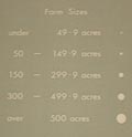
Circular symbols are plotted for each farm? size and colour showing size and type. |
||
|
(example Carlisle Library : ZA650)
|
||
| map feature:- | table of symbols & up is N & scale line & county & land use | |
| inscription:- |
printed upper right
Types of Farm / in the / Northern Regions |
|
| inscription:- |
printed lower right
The type of farm has been determined according to the method described in / FARM CLASSIFICATION IN ENGLAND AND WALES 1963. (H.M.S.O. 1965) / ... |
|
| inscription:- |
printed lower left
Compiled and drawn by the cartographic staff of the Northern region / Agricultural Development and Advisory Service, Ministry of Agriculture, / Fisheries and Food, Newcastle. / Based on parish statistics derived from the June 1968 Agricultural Census. |
|
| inscription:- |
printed lower left
... 1971. Ministry of Agriculture, Fisheries and Food |
|
| wxh, sheet:- | 118x84cm | |
| wxh, map:- | 1111x774mm | |
| inscription:- |
printed with scale line
MILES |
|
| scale line:- | 25+5 miles = 190.3 | |
| scale:- | 1 to 250000 ? (1 to 253706 from scale line) | |

|
||
|
||
| sources:- |
Carlisle Library Maps |
|
| items seen (illustrated items in bold):- | ||

|
Carlisle Library : Map 286 -- map -- Types of Farm in the Northern Regions | |