 New Map of Westmorland

|

|
|
|
map type:- Lodge 1788-90 |
|
|
|
Maps, New Map of Westmorland, scale about 4.5 miles to 1
inch, by John Lodge, London, published by R Butters et al,
1790; published 1790-95, and A Map of Cumberland, scale
about 6 miles to 1 inch, by John Lodge, published by J
Murray, London, 1788; published 1788-95.
Published, in 'The Political Magazine and Parliamentary, Naval, Military, and Literary Journal ... London: Printed for R. Butters, No.79, Fleet Street.' 1790. The journal size is 5 x 7 1/2 ins; there was a map of England in the issue for 30 Nov 1785. The maps were reprinted 1795, the imprints removed. |
||
|
(example Armitt Library : ALMC2008.14.64)
|
||
| map feature:- | table of symbols & compass rose & up is N & scale line & lat and long scales (rectangular projection) & lat and long grid (minimal) & sea plain & coast shaded & rivers & lakes & relief & hillocks & woods & trees & forests & parks & county & settlements & roads | |
| inscription:- |
printed lower right
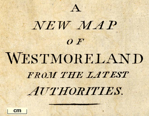
A / NEW MAP / OF / WESTMORELAND / FROM THE LATEST / AUTHORITIES. |
|
| inscription:- |
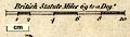
printed above scale line
Brtish Statute Miles 69 to a Dege. |
|
| wxh, sheet:- | 36x30.5cm | |
| wxh, plate:- | 333x275mm | |
| wxh, map:- | 318x257mm | |
| scale line:- | 10 miles = 53.0 mm | |
| scale:- | 1 to 300000 ? (1 to 303650 from scale line wrongly assuming a statute mile) | |
| longitude, Kendal:- | 2d 51m W | |
|
||
|
||
| references:- |
: 1788 (29 February): Political Magazine, The: (London) : 1790 (30 September): Political Magazine, The: (London) |
|
| sources:- |
Chubb 1927 (CCXLIX) Armitt Library |
|
| items seen (illustrated items in bold):- | ||

|
Armitt Library : ALMC2008.14.64 -- map -- New Map of Westmoreland | |