 Westmoreland

|

|
|
|
map type:- Johnson 1847 |
|
|
|
Maps, Westmoreland, scale about 6 miles to 1 inch, and
Cumberland? engraved by Lizars, Edinburgh, published by
Thomas Johnson, Manchester, 1847.
Published in 'Johnson's Atlas of England: with all the Railways containing forty two Separate Maps of the Counties and Islands. Manchester published by Thos. Johnson, 1847. Lizars sc.' The map has a badge of Kendal; the atlas has a title page, contents list, and coarse lithograph maps; its size is 8 1/8 x 10 1/2 ins. BUT there are no railways. |
||
|
(example Armitt Library : ALMC2008.14.44)
|
||
| map feature:- | title cartouche & vignettes & decorative border & north point & up is N & scale line & lat and long scales (rectangular projection?) & sea shaded (?) & coast line & rivers & lakes & relief & hill hachuring & forests & parks & county & wards & settlements & roads | |
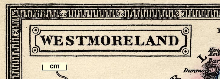
| inscription:- |
printed title cartouche, upper left
WESTMORELAND |
|
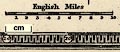
| inscription:- |
printed above scale line
English Miles |
|
| wxh, sheet:- | 28x21.6cm | |
| wxh, map:- | 229x165mm | |
| scale line:- | 10 miles = 42.5 mm | |
| scale:- | 1 to 380000 ? (1 to 378669 from scale line assuming a statute mile) | |
| longitude, Kendal:- | 2d 49m W (?) | |
|
||
| references:- |
Johnson, Thomas: 1847: Johnson's Atlas of England:
(Manchester) |
|
| sources:- |
Chubb 1927 (DXXIII) Armitt Library |
|
| items seen (illustrated items in bold):- | ||

|
Armitt Library : ALMC2008.14.44 -- map -- Westmoreland | |