 Irish Sea

|

|
|
|
map type:- Collins 1693 |
|
|
|
Chart, of the Irish Sea, including the coast of Cumbria -
Lancashire and Cumberland, scale about 6.5 miles to 1 inch,
by Captain Greenvile Collins, published 1693; published up
to 1753 at least.
Published in 'GREAT-BRITAIN'S COASTING PILOT. In Two PARTS. Being a NEW and EXACT Survey of the Sea-Coast OF ENGLAND and SCOTLAND From the RIVER of Thames to the Westward and Northward, WITH THE ISLANDS of SCILLY, And from thence to CARLISLE. Likewise the Islands of ORKNEY and SHETLAND. DESCRIBING All the Harbours, Rivers, Bays, Roads, Rocks, Sands, Buoys, Beacons, Sea-Marks, Depths of Water, Latitude, Bearings and Distances from Place to any Place, and how to Harbour a Ship in the same with Safety. With Directions for Coming into the CHANNEL between ENGLAND and FRANCE. By Captain GREENVILE COLLINS, Hydrographer in Ordinary to the KING'S most excellent MAJESTY. LONDON: Printed for W. and J. MOUNT and T. PAGE, on Tower-Hill. M,DCC,LIII.' ie 1753. Published, perhaps, by Mount and Page, London, 1785? |
||
|
(example Carlisle Library (97))
|
||
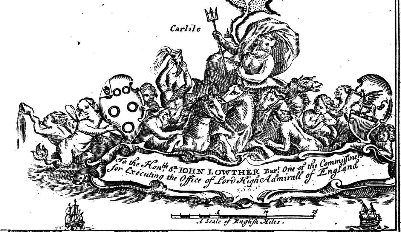
| map feature:- | dedication & coat of arms & compass rose & up is W & rhumb lines & scale line & latitude scale & sea plain & galleons & depth soundings & anchorages & coast shaded (inland) & foreshore sands & sandbanks & coast views & county & settlements (few) | |
| inscription:- |
printed dedication, scroll cartouche, lower right
To the Honble. SR. JOHN LOWTHER Bart. On of the Commissioners / for Executing the Office of Lord High Admiral of England decorated with Neptune, horses, coat of arms, etc |
|
| inscription:- |
printed with scale line
A Scale of English Miles |
|
| wxh, sheet:- | 62.5x52.5cm | |
| wxh, plate:- | 573x456mm (?) | |
| wxh, map:- | 557x441mm | |
| scale line:- | 15 miles = 60.3 mm | |
| scale:- | 1 to 400000 ? (from scale line, assuming a statute mile) | |
|
||
| references:- |
Collins, Greenvile: 1693 & 1753: Great Britain's Coasting
Pilot: Mount, W and J & Page, T (London) |
|
| sources:- |
Hydrographic Office Carlisle Library Maps |
|
| items seen (illustrated items in bold):- | ||

|
Carlisle Library : Map 251 -- chart -- Irish Sea | |