 New Map of England and Wales

|

|
|
|
map type:- Cary 1798 map 1 |
|
|
|
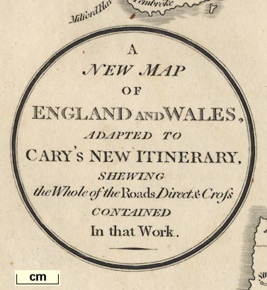
Road map, uncoloured engraving, A New Map of England and
Wales, scale about 20 miles to 1 inch, by John Cary,
published by G and J Cary, 86 St James's Street, London,
11th edn 1828.
The map is an index map for Cary's New Itinerary, 11th edn, 1828, having route references printed by roads on the map. It shows the principal roads of the country graded as Direct, Mail, or Cross roads. The map seems to be printed on two pieces of paper which are tipped in to face each other at the end of the preface. (I have not found out what map/s exist in the first, 1798, and other editions of the itinerary.) |
||
|
(example map private collection (20_1))
|
||
| map feature:- | folded (printed in sections, leaving margins within the map for the folds) & oval cartouche & up is N & scale line & sea plain & coast shaded & county & table of data (counties) & settlements & roads & post roads | |
| inscription:- |
printed title cartouche, lower left
A / NEW MAP / OF / ENGLAND AND WALES, / ADAPTED TO / CARY'S NEW ININERARY, / SHEWING / the Whole of the Rods, Direct & Cross / CONTAINED / In that Work. |
|
| inscription:- |
printed bottom centre
London : Published by G. & J. Cary No.86 St. James's Street. |
|
| inscription:- |
printed
REFERENCES / ... / 35 Lancashire / 36 Yorkshire / 37 Westmoreland / 38 Cumberland / 39 Durham / 40 Northumberland table of counties |
|
| wxh, sheet:- | 42.5x53cm | |
| wxh, map:- | 41x50.5cm (?) | |
| scale line:- | 50 miles = 62.6 mm | |
| scale:- | 1 to 1300000 ? (1 to 1285419 from scale line) | |
|
||
|
||
| sources:- |
David Webb Collection |
|
| items seen (illustrated items in bold):- | ||

|
Hampshire Museums : B1990.1795.1 -- road map -- Map of England and Wales | |
| see:- | Hampshire Museums : B1990.1795.2 -- road map -- New Map of the Cross Roads | |
|
|
private collection (20_1) -- road map -- New Map of England and Wales | |