 Lake District (?)

|

|
|
|
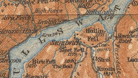
map type:- Baedeker 1927 map 2 |
|
|
|
Map, The Lake District, now Cumbria, scale about 3 miles
to 1 inch, by Wagner and Debes, Leipzig, Germany, 1927?
based on the Ordnance Survey.
Tipped in to support the Lake District section in Baedeker's Great Britain, 8th edn 1927. Shows the central Lake District only. There are a general map of England and Wales and an index map, in the same guide book. |
||
|
(map example JandMN (68_3)
|
||
| map feature:- | up is N & scale lines & rivers & lakes & relief & hill hachuring & hill shading & spot heights & county & settlements & roads & railways | |
| inscription:- |
printed bottom left and right
Wagner & Debes' Geogl. Estabt. Leipzig / Based on the Ordnance Survey by permission |
|
| wxh, map:- | 201x185mm | |
| scale line:- | 6 miles = 50.3 mm | |
| scale:- | 1 to 190000 ? (1 to 191969 from scale line) | |
| sources:- |
JandMN Collection |
|
| items seen (illustrated items in bold):- | ||

|
JandMN (68_3) -- map -- Lake District | |