 Stukeley 1723

|

|
|

|
back to object record | |
| William Stukeley | ||
|
William Stukeley was born 1687. He was an antiquary and
author, and became Secretary to the Society of Antiquaries
which he shared in founding. He died 1765.
|
||
|
The roman place names on the map, and their interpretation
as contemporary places by William Stukeley in 1723, must not
be regarded as 'truth'. More reliable authority is in River
and Smith (see references), who believe that Stukeley, for
place name interpretation, was:-
|
||
|
... an inventive romantic who represents a step backwards
from the place reached by Camden, Horsley and others. ...
|
||
|
... alas, was an enthusiastic victim of the spurious De Situ
Britanniae of 'Richard of Gloucester'; he [Stukeley] was a
prime propagator of this fiction, and by his authority in
his otherwise valuable book served to establish the text as
part of the canon of our toponymy. ...
|
||
|
So: beware using place names from this map!
|
||
|
In most of his place labels Stukeley gives a latin version
in italic lowercase, with an English version in upright
lowercase beneath it.
|
||
| Antonine Itineraries | ||
|
The
|
||
Itinerarium Provinciarum Antonini Augusti |
||
|
are a collection of 225 route descriptions for the roman
empire; from the middle east to the west of Portugal and
Wales, from north Africa to Scotland. Each itinerary is a
list of place names with the distances from stage to stage.
It is not clear who Antonini Augusti was. The itineraries
are not all of one date. The routes in Britain have elements
from the time of Trajan, 98-117, to Diocletian, 284-305;
overall the data collection seesm to be in the 3rd century,
say from AD214-284.
|
||
| MAP FEATURES | ||
|
|
||
|
title cartouche
picture frame cartouche |
Printed upper right is a rectangular cartouche whose
exact picture frame style is found on the Hampshire map from
Moll's 1724 atlas:-
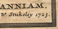
Ingratiam Itinerantium / Curiosorum, ANTONINI / Aug. ITINERARIUM per / BRITANNIAM. / tentavit W. Stukeley 1723. roughly translated as:- In gratitude to curious travellers, the Itineraries through Britain of Antonini Aug., attempted by William Stukeley, 1723. The map is a plot of the Antonine Itineraries on an outline of England and Wales. |
|
|
|
||
|
orientation
up is N |
There is no compass rose; the map is printed with north
at the top of the page.
|
|
|
|
||
|
lat and long
lat and long scales scale |
The borders have scales of latitude and longitude with
the meridians clearly converging up the page. The prime
meridian, 0 degrees Longitude, passes through London. There
are marks and labelling at 1 degree intervals. The map
covers 2 degrees E to 6 1/4 degrees W, 50 degrees to 55 1/2
degrees N; all of England and Wales, the edges of France,
Scotland and Ireland.
5 degrees latitude = 227.5 mm gives a scale 1 to 2446557; the map scale is about:- 1 to 2400000 39 miles to 1 inch |
|
|
|
||
|
scale line
scale |
A scale of
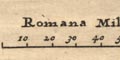
Romana Milliari is printed upper left, marked and labelled at 10 miles intervals. The 80 roman miles = 52.4 mm giving a scale about:- 39 roman miles to 1 inch. A better estimate of scale can be made from town positions, comparing known town-town distances, using DISTAB.exe. The map scale is about:- 1 to 3500000 55 miles to 1 inch The map maker's miles are a:- roman mile = 1.41 statute miles |
|
|
|
||
|
sea area
sea plain |
The sea areas are plain. Some sea areas are labelled,
eg:-
OCEANUS BRITANNICUS for the English Channel. It is possible to recognise sea areas, eg:- Solway Firth Morecambe Bay |
|
|
|
||
|
coast line
coast shaded harbours antiquities |
The coast line is shaded for emphasis. The coast line is
also tinted; pale green-blue around England and Wales, pale
green around France, pink for Scotland and Ireland, and the
Isle of Man.
Some headlands are noticed, eg:- Dumnoniorum Prom. / Start Pt. where there is a roman place name. Hampshire's harbours are not noticed. Elsewhere some are labelled, eg:- Dubris Portus / Dover Portus Madurni / Aldrington The latter is an example of misinterpretation by Stukeley. It is likely to be Portus Ardaoni thought to be the roman fort at Portchester, Hampshire. |
|
|
|
||
|
rivers
antiquities |
Rivers are shown by a wiggly line. Hampshire has the
Stour and Avon, Test, Itchin, and perhaps the Rother. Rivers
are not labelled, but see:-
Tamesis Fl. Sabrina AEstarium at these great river mouths. It is possible to recognise:- River Eden - past Carlisle and Brough. River Caldew - by Carlisle and Old Carlisle River Lune - from near Orton to the coast River Derwent ? - from Derwent water? to the coast River Eamont? from Ullswater? to the Eden. |
|
|
|
||
| lakes |
Some lakes are drawn in outline. It is possible to guess
at the identity of some, perhaps:-
Windermere? Derwent Water? Ullswater? |
|
|
|
||
|
antiquities
tribal areas |
Ancient british tribal areas are not generally noticed.
Three areas are labelled, at the edges of roman
influence:-
CORINAVII DUMNONII in the far south west, and:- OTODINI in the scottish borderlands. |
|
|
|
||
|
settlements
antiquities |
Settlements are positioned by a circle and most have a
pair of towers to indicate a town. Less significant places
have no, or smaller, towers. Only settlements along the
itineraries are marked; labelled in Latin and English as
noted above.
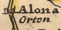
Alona / Orton The place name interpretations MUST be read in conjunction with a more recent authority, eg Rivet and Smith. |
|
|
|
||
|
antiquities
roman sites roman roads |
The itineraries are drawn as roads by double lines,
tinted yellow. Each road is labelled, if you look carefully,
with its number, eg:-
ITER X. and might be named, eg:- VIA ICENIANA / Ikening Street 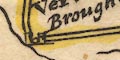
Four of the itineraries are relavant to Cumbria. From the south east, through Ebchester, Overborow, Orton, Overborough, Castlesteds to Caervoran on Hadrian's Wall. From the south east through Bowes, Brough, Whitley castle, to Caervoran on Hadrian's Wall. From Boulness through Old Carlile to Caervoran on Hadrian's Wall. From Caervoran to the north. |
|
|
|
||
|
antiquities
roman wall |
Hadrian's Wall is drawn as a wall with ?milecastles or
forts, 15 of them across the country from Bowness to the
east coast.
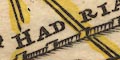
HADRIANI VALLUM |
|
| Cumbrian Places | ||
|
The roman placenames given on the map do not accord with the
best understanding of today (see Rivet and Smith 1979); the
map is interesting as a demonstration of early 18th century
research, but not useful as a reference source in the 21st.
The places on the map in the Cumbrian area are:-
|
||

|
||
|
|
||
| Voreda |
Stukeley:-
Plotted roughly as the roman fort at Birdoswald on Hadrian's Wall; interpreted as Caer Voran. Rivet and Smith 1979:- The name Voreda belongs to the roman fort at Old Penrith, Plumpton Wall, Cumberland. |
|
|
|
||
| Lugubalum |
Stukeley:-
Plotted at Carlisle; named Carlile. Rivet and Smith 1979:- Luguvalium, the roman town of Carlisle. |
|
|
|
||
| Glanoventa |
Stukeley:-
Plotted perhaps as the roman fort at Old Penrith, Plumpton Wall, Cumberland. Rivet and Smith 1979:- This name belongs to the roman fort at Ravenglass, Muncaster, Cumberland. |
|
|
|
||
| Castra Explorata |
Stukeley:-
Plotted roughly at the roman fort at Old Carlisle, Cumberland; interpreted as Old Carlile. Rivet and Smith 1979:- This name belongs to the roman fort at Netherby, Cumberland. |
|
|
|
||
| Galava |
Stukeley:-
Plotted roughly at the roman fort at Brougham, Westmorland; interpreted as Overborough. Rivet and Smith 1979:- This name belongs to the roman fort at Ambleside, Westmorland. |
|
|
|
||
| Verteris |
Stukeley:-
Plotted as the roman fort at Brough Castle, Westmorland, and interpreted as Brough. Rivet and Smith 1979:- The roman fort at Brough Castle, Westmorland. |
|
|
|
||
| Alona |
Stukeley:-
Plotted roughly at the roman fort at Watercrook, Westmorland; interpreted as Orton. Rivet and Smith 1979:- Probably Alauna, the roman fort at Watercrook, Westmorland. |
|
|
|
||
| Galagum |
Stukeley:-
Plotted roughly at the roman fort at Overborough, Lancashire. Rivet and Smith 1979:- This is probably the roman fort, Calacum, at Overborough, Lancashire. |
|
|
|
||
| Brennetonacis Veteranorum |
Stukeley:-
Plotted roughly at the roman fort at Ribchester, Lancashire; interpreted as Ebchester. Rivet and Smith 1979:- The roman fort, Bremetonacum Veteranorum, at Ribchester, Lancashire. |
|
| References | ||
Rivet, A L F & Smith, Colin: 1981: Place-Names of Roman Britain: Batsford:: ISBN 0 7134 2077 4 |
||
Lakes Guides menu.