 Pigot 1835

|

|
|

|
back to object record | |
| MAP FEATURES | ||
|
Note that places shown on the map outwith Westmorland are
mostly ignored.
|
||
|
|
||
|
title cartouche
plain cartouche engraver |
Printed in a plain cartouche in the upper border:-
WESTMORELAND. Pigot & Slater, Engravers, Manchr. |
|
|
|
||
| table of symbols |
Printed lower right is an:-
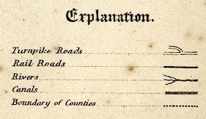
Explanation. Turnpike Roads [double line] Rail Roads [solid bold line] Rivers [tapering wiggly line] Canals [triple line, light bold light] Boundary of Counties [dotted line] |
|
|
|
||
|
orientation
north point up is N |
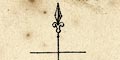
Printed upper left is a north point; N-S line, E-W cross line, North marked by a spear point. The map is printed with North at the top. |
|
|
|
||
|
scale line
scale |
Printed above scale line, which is in a cartouche in the
lower border, is:-
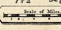
Scale of Miles. The 10 miles = 25.9 mm gives a scale 1 to 621368 assuming a statute mile. The map scale is about 1 to 620000 10 miles to 1 inch |
|
|
|
||
| lat and long scales |
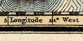
Printed in the map borders are scale of latitude and longitude for a rectangular, or perhaps trapezoidal, projection; chequered in minutes, labelled at 5 minutes intervals. There are a couple of curious errors: the top longitude scale has 30 minutes between 2d 35m and 3d 0m, partly hidden by the title cartouche; and the 3 degree meridian is labelled 11 or II degrees. Reading from the scales the longitude, Kendal = 2d 55m W The value from Greenwich is 2d 44.8d W, suggesting a prime meridian for the map 10m E of Greenwich. This seems unlikely and is better explained as a mapping error. |
|
|
|
||
| sea plain |
The sea area is plain, though covered by the coast form
lines.
|
|
|
|
||
|
coast line
coast form lines |
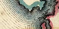
The coast line is emphasized by graduated form lines, and by a blue tint. Foreshore sands are not drawn, but might be labelled, eg:- Leven Sands Duddon Mouth & Sands |
|
|
|
||
|
rivers
bridges |
Rivers are drawn by a tapering wiggly line. A few rivers
are labelled, eg:-
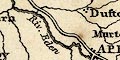
Riv. Eden River Ken Lune River The label might be in the river estuary. Bridges are not specially noticed but may be inferred where a road crosses and interrupts a stream. |
|
|
|
||
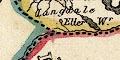
| lakes |
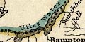
Lakes are drawn in outline with shore form lines, tinted blue. The following lakes are labelled:- Eller Wr. Grasmere Lake Hawes Water Ulles Water Winander Mere Other lakes might be recognized, eg:- Angle Tarn (perhaps) Brothers Water Codale Tarn (perhaps) Easedale Tarn (?) Hayes Water Kentmere tarn Rydal Water (included in Grasmere lake) Skeggles Water |
|
|
|
||
| relief |
No relief is indicated by cartographic symbols, but a few
hill and valley areas are labelled, eg:-
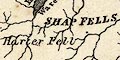
SHAP FELLS Crow Brow (Ancrow Brow?) Borrow Dale |
|
|
|
||
| forests |
Forests are not marked but might be labelled, eg:-
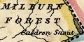
MILBURN FOREST Martindale Forest |
|
|
|
||
| county |
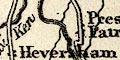
The county boundary is a bold dotted line, emphasized by a tint on the inside of the county and each adjacent county: Westmorland yellow, Lancashire pink, Cumberland green, Durham green, Yorkshire blue. Adjacent counties are labelled, eg:- LANCASHIRE CUMBERLAND Some larger places and roads are marked outwith the county for the sake of continuity. |
|
|
|
||
| settlements |
Settlements are marked by a few blocks, differentiated by
style of labelling.
|
|
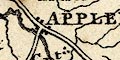
| towns |
group of blocks; labelled in upright block caps, eg:-
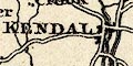
APPLEBY AMBLESIDE ORTON The towns shown are listed:- |
|
|
villages
hamlets |
blocks; labelled in upright lowercase text, eg:-
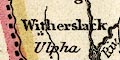
Witherslack Shap |
|
|
Other map features are labelled in italic lowercase
text.
|
||
|
|
||
| roads |
A network of roads is drawn by double line. Some of the roads have one line a little bolder, but the table of symbols does not note this feature, it just gives turnpike roads as double lines without the emphasis. The more important roads seem to be:- from the south, Lancashire; through Burton, Kendal, Shap, Westmorland; to Penrith, Cumberland. from Kendal through Ambleside, Westmorland; to Keswick, Cumberland. from the east, Yorkshire; through Brough and Appleby, Westmorland; to Penrith, Cumberland. |
|
|
|
||
| canals |
The Lancaster Canal is drawn by a triple line, light bold light, from the south, into Kendal. |
|
|
|
||
| railways |
Railways are included in the table of symbols, which
presumably applies to all maps in the series. This county
had no railways in 1835.
|
|
Lakes Guides menu.