 Philip 1900s

|

|
|

|
back to object record | |
| MAP FEATURES | ||
|
Only the Cumbria area of the map is studied.
|
||
|
|
||
|
title
map maker |
Printed upper right:-
ENGLAND AND WALES Printed at the bottom, left and right:- George Philip & Son, Ltd. / The London Geographical Institute |
|
|
|
||
|
orientation
up is N |
The map is printed with North at the top.
|
|
|
|
||
|
scale line
scale |
The map has a scale of:-
English Miles, 69.15 - One Degree chequered in miles to 10 then in 10s, labelled at 10s. The 50 miles = 72 mm, approximately, giving a scale 1 to 1117600, The map scale is about:- 1 to 1100000 18 miles to 1 inch There is also a scale of:- Kilometres, III.3 - One Degree |
|
|
|
||
| table of symbols |
There is a minimal table of symbols:-
Heights in feet Railways thus [double line chequered] Submarine cables [dotted line, labelled] Sub. Cable Steamer Routes [dotted line] (Distances in Nautical Miles) |
|
|
|
||
|
lat and long scales
lat and long grid |
Printed in the map borders are scale of latitude and
longitude; chequered at 10 minute intervals, labelled at
degrees. The bottom scale is labelled:-
Longitude West of Greenwich / Longitude East of Greenwich A graticule is printed over the map at 1 degree intervals. The prime meridian, in the sea south of Newhaven, is labelled:- Meridian of Greenwich |
|
|
|
||
|
sea area
sea tinted |
The sea area is printed blue. Some sea areas are
labelled, eg:-
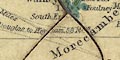
Morecambe Bay IRISH SEA Solway Firth |
|
|
|
||
|
coast line
coast tinted headlands |
The coast line is emphasized by a blue tint on the sea side - similar to the way a county boundary is treated. A headland might be noticed, eg:- St. Bees Hd. |
|
|
|
||
|
rivers
bridges |
Rivers are drawn by a wiggly line tapering upstream. Some
rivers are labelled, eg:-
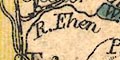
R. Ehen R. Eden Bridges are implied where a road crosses and interrupts a stream. |
|
|
|
||
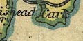
| lakes |
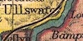
Lakes are drawn in outline, tinted blue. Some lakes are labelled:- Bassenthwaite Wr. Buttermere Coniston L. Crummock Wr. Ennerdale Wr. Hawes Wr. Lowes Wr. Ullswater Wast Wr. Windermere L. Others might be recognized, eg:- Thirlmere |
|
|
|
||
|
relief
hill hachuring spot heights |
Some relief is indicated by hill hachuring. Some hills
are labelled by name, usually with a spot height, eg:-
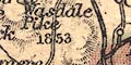
Wasdale Pike / 1853 Skiddaw / 3054 High Street Black Law 2052 [no name] |
|
|
|
||
| county |
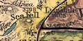
County boundaries are a dotted line tinted on the inner side with a bold, then a pale wash; Westmorland pink, Cumberland yellow, Lancashire green, Yorkshire pink, Northumberland orange, Durham green. And, remember, the sea is blue. Five colours have been used, one more than needed: nevertheless, adjacent counties Westmorland and Yorkshire are the same colour. The jigsaw is cut into county pieces, Westmorland and Cumberland are each one piece; and so is Lancashire, Morecambe Bay being included to hold the separate areas together. |
|
|
|
||
| settlements |
Settlements are marked by a circle, differentiated by
style of labelling.
|
|
| cities |
circle, slightly larger; labelled in upright lowercase
text, also a little larger, eg:-
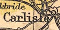
Carlisle |
|
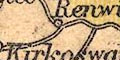
| towns |
circle; labelled in upright lowercase text, eg:-
K[e]ndal Penrith Ulverston |
|
|
villages
hamlets |
circle; labelled in italic lowercase text, eg:-
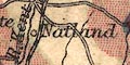
Natland Ulpha Morland |
|
|
|
||
| roads |
A network of roads is drawn by double lines. The sands roads are not shown. |
|
|
|
||
| railways |
Railways are drawn by a double line with a chequer infill. Stations are not marked particularly. The following railways are shown in Cumbria (roughly):- |
|
| Maryport and Carlisle Railway |
opened 1845
from Maryport, through Aspatria, Wigton, to Carlisle, Cumberland. |
|
| Lancaster and Carlisle Railway |
opened 1846
from Lancaster, through Carnforth, Lancashire; near Kendal, Westmorland; then Penrith to Carlisle, Cumberland. |
|
| Kendal and Windermere Railway |
opened 1846
from the Lancaster and Carlisle Railway, through Kendal, to Windermere, Westmorland. |
|
| Cockermouth and Workington Railway |
opened 1847
from Cockermouth to Workington, Cumberland. |
|
| Whitehaven Junction Railway |
opened 1847
from Whitehaven, through Workington, to Maryport, Cumberland. |
|
| Caledonian Railway |
opened 1850
from Carlisle, Cumberland; to Gretna and beyond, Scotland. |
|
| Ulverstone and Lancaster Railway |
opened after 1851
from Ulverston, through Cartmel, to Carnforth and Lancaster, Lancashire. |
|
| Newcastle and Carlisle Railway |
opened 1852
from the east through Haltwhistle, Northumberland; near Bampton, to Carlisle, Cumberland. |
|
| Port Carlisle Dock and Railway |
opened 1854
from Carlisle, to Port Carlisle, Cumberland. |
|
| Whitehaven, Cleator and Egremont Railway |
opened 1856-57
from Whitehaven, to Egremont, and a route through Cleator, Cumberland. |
|
| Carlisle and Silloth Bay Railway |
opened 1857
branch off the Port Carlisle Dock and Railway, to Silloth, Cumberland. |
|
|
North Western Railway
Low Gill and Ingleton branch railway |
opened 1859?
from the south, Lancashire; near Kirkby Lonsdale, to the Lancaster and Carlisle Railway, Westmorland. |
|
| Coniston Railway |
opened 1859-60
from Broughton to Coniston, Lancashire. |
|
| South Durham and Lancashire Union Railway |
opened 1861
from Tebay, through Kirkby Stephen, Westmorland; east into Yorkshire and Durham. |
|
| Border Union Railway |
opened 1861
from Carlisle, through Longtown, Cumberland; into Scotland. |
|
| Eden Valley Railway |
opened 1862
from Kirkby Stephen or Brough, through Appleby, to the Lancaster and Carlisle Railway at Clifton, Westmorland. |
|
| Cockermouth, Keswick and Penrith Railway |
opened 1864-65
from Cockermouth, through Keswick, to Penrith, Cumberland. |
|
| Furness Railway |
opened 1867
from Broughton, to Piel Pier, Lancashire; branch through Dalton to Ulverston, Lancashire; branch to Barrow, Lancashire. |
|
| Derwent branch railway |
opened 1867
joining the Maryport and Carlisle Railway and the Cockermouth to Workington Railway, Cumberland. |
|
| Lakeside branch railway |
opened 1869
from Plumpton to Windermere lake, Lancashire. |
|
| Egremont and Sellafield branch railway |
opened 1869
from Egremont to Sellafield, Cumberland. |
|
| Solway Junction Railway |
opened 1869-70
from Aspatria to Port Carlisle, Cumberland, across the Solway into Scotland. |
|
| Ravenglass and Eskdale Railway |
opened 1875-76
from Ravenglass up Eskdale, Cumberland. |
|
| Settle and Carlisle Railway |
opened 1876
from Settle, Yorkshire; through Kirkby Stephen, Appleby, Westmorland; to Carlisle, Cumberland. |
|
| Arnside to Hincaster branch railway |
opened 1876
Lancashire; Westmorland. |
|
| Cleator and Workington Junction Railway |
opened 1879
in the area of Cleator, Cumberland. |
|
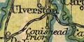
| Conishead Priory branch railway |
opened 1883
from Ulverston to Conishead, Lancashire. |
|
|
|
||
| shipping routes |
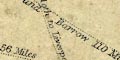
Shipping routes are drawn by a dotted line across the sea, labelled with destinations and distance:- Douglas to Silloth 59 Silloth to Liverpool 110 Miles Whitehaven to Liverpool 85 Miles Douglas to Whitehaven 4[ ] Miles Belfast to Fleetwood and Barrow 110 Miles |
|
|
|
||
| miscellaneous | ||
|
|
||
| telegraphs |
A dotted line marks the cable from St Bees to the Point
of Ayre, Isle of Man:-
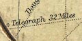
Submarine Telegraph 32 Miles |
|
Lakes Guides menu.