 Mogg 1822 map

|

|
|

|
back to object record | |
| MAP FEATURES | ||
|
Remember that the map is of the Lakes, and does not included
the whole of the counties that it shows.
|
||
|
|
||
| title |
Printed right centre:-
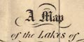
A Map of the Lakes of CUMBERLAND, Westmorland, and LANCASHIRE. |
|
|
|
||
|
orientation
north point up is E |
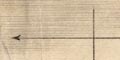
Printed lower right is a north point, N-S line; E-W cross line, North marked by an arrow. The map is printed with East at the top of the sheet. |
|
|
|
||
|
scale line
scale |
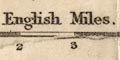
Printed lower right is a scale of:- English Miles. chequered at quarter, half, then miles, labelled at mile intervals. The 5 miles = 37.6 mm gives a scale about 1 to 214009. The map scale is about:- 1 to 210000 3.5 miles to 1 inch |
|
|
|
||
|
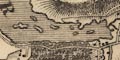
sea area
sea plain |
The sea area is plain.
|
|
|
|
||
|
coast line
coast shaded |
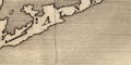
The coast line is shaded for emphasis. |
|
|
|
||
|
rivers
bridges |
Rivers are mostly drawn by wiggly line tapering upstream. Broader reaches might be drawn by a double line, and might have islands marked, as in the Lune by Aughton. Some rivers are labelled, eg:- River Kent Lune Riv. Trout Beck R. Mint and an estuary might be labelled, as:- KENT MOUTH 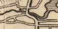
Bridges are implied where a road crosses and interrupts a stream. ?None are labelled. Notice the bridge across Thirlemere. |
|
|
|
||
| lakes |
Lakes are drawn on outline with coast shading. Nearly all are labelled:- Base[ ]le [ r]n [Easedale Tarn] BASSENTHWAITE WATER Blea Tarn Burnmoor Tarn Buttermere water CONISTON WATER CRUMMOCK WATER DERWENT WATER Dovock Water Easthwaite water Elter Water Ennerdale water Goats water Grasmere Lake HAWES WATER Loweswater Rydal Lake Thirle Mere ULLES WATER WAST WATER WINANDER MERE LAKE Some other lakes might be recognised with more or less certainty:- Brothers Water Out Dubs Tarn Skeggles Water Watenlath Tarn Islands are drawn in larger lakes and might be recognised, as Belle Isle in Windermere for example. |
|
|
|
||
|
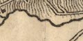
relief
hill hachuring |
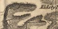
Relief is indicated by hill. hachuring. There is an overall impression of a hilly centre to the Lakes region, with plateau mountain tops. Some hills and hill areas are labelled, eg:- SHAP FELLS SKIDDAW Farleton Knot Kidsty Pike Witherslack Scar And some valleys are labelled, eg:- LANGDALE PATTER DALE KENTMERE VALLEY |
|
|
|
||
|
woods
forests trees |
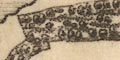
Woodland is indicated by groups of tree symbols with undergrowth or rough ground below. ?No woods are labelled. But some forests areas, without trees, are labelled, eg:- COPELAND FOREST MARTINDALE FOREST |
|
|
|
||
| parks |
Parks are drawn in outline with a paling fence, the
interior pecked, perhaps with trees are drives, and perhaps
a great house the park might be labelled or named by its
house, eg:-
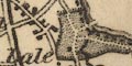
Dalemain Gobarrow Park Levins Pa. |
|
|
|
||
| county |
County boundaries are a dotted line. The county areas are labelled, eg:- PART OF WESTMORLAND PART OF CUMBERLAND At the meet of the three counties, on Wrynose, is labelled:- County Stones |
|
|
|
||
|
settlements
street plan |
Settlements are marked by blocks, perhaps with a cross
for a church, and differentiated by style of labelling.
|
|
| towns |
group of blocks on a street plan; labelled in italic
block caps, eg:-
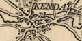
KENDAL AMBLESIDE |
|
| villages |
block or blocks, perhaps a cross; labelled in upright
lowercase text, eg:-
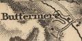
Buttermere Bampton Clifton Wastdale |
|
| hamlets |
block or blocks, labelled in italic lowercase text,
eg:-
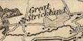
Great Strickland Grange [Grange over Sands] Penruddock |
|
|
Italic lowercase is used general for map features. The
differentiation of hamlets and villages is not to be
trusted?
|
||
|
|
||
|
roads
sands roads |
A network of roads is drawn by double lines, solid and dotted indicating fenced and unfenced roads. Main roads are drawn slightly wider and have the lines light bold. The routes across Lancaster Sands, Leven Sands - two routes, and Duddon Sands are marked. |
|
|
|
||
| canals |
A canal is drawn by a bold line. The:-
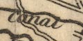
Lancaster Canal is shown running from Kendal, and with care its route can be seen all the way to Lancaster. The tunnel at Hincaster is dotted. |
|
|
|
||
| miscellaneous | ||
|
|
||
| stones |
At the meet of the three counties, Westmorland,
Cumberland, and Lancashire, is labelled:-
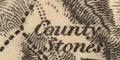
County Stones |
|
|
|
||
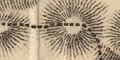
| race courses |
Labelled beside the Milnthorpe road south of Kendal
is:-
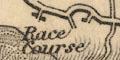
Race Course |
|
Lakes Guides menu.