 Morden 1676

|

|
|

|
back to object record | |
| MAP FEATURES | ||
|
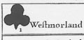
Each of the set of 52 playing cards shows a county of
England: Westmorland, ace of clubs; Cumberland, deuce of
clubs; Lancashire, tray of clubs.
|
||
|
|
||
| general map |
One card, not one of the cards for playing, is:-
A Mapp of England and wales with county outlines labelled, eg:- We [Westmorland] Cu [Cumberland] La [Lancashire] and a description of the set:- The 52 Counties of England and Wales, Geographically described in a pack of Cards, whereunto is added ye Length, Breadth, & Circuit. of each County the Latitude Scituation and distance from London of ye principal Cities. Towns. and Rivers. with other Remarks as plaine and ready for the playing all our English Games, as any of ye Common Cards. |
|
|
|
||
| table of symbols |
A non playing card has:-
The Explanation of these Cards. The four Suites are the 4 parts of England, the 13 Northern Counties are Clubs, the Western are Spades, the Eastern are Hearts, and the Southern are Diamonds. in each Card you have a Map of the County, with the cheife Towns and Rivers, a Compas for the Bearings, and a Scale for Mensuration. there is also given the Length, Bredth, and Circumference of each County, the Latitude of the Cheife Citty or Towne, and its Distance from London, First the Reputed and then the Measured Miles, by Esqr: Ogilby with his leave we have Incerted. there is also the Road from London to each Citty or Towne, the great Roads are drawn with a double line, the other Roads a single line, as also the cheif Hills and other Remarks The use of these Cards are the same with the Common Cards in all respects only useing the Numbers in these insted of the spots in the Other. |
|
|
|
||
|
title cartouche
plain cartouche table of data |
Printed at the top of each playing card in a plain
cartouche is the county name, suit and number:-
Westmorland [clubs] I Cumberland [clubs] II Lancashire [clubs] III At the bottom of the card there is a panel of general information about the county, eg, Westmorland:- Length. - 38. / Bredth. - 33 / Circumference. - 112. / Kendal. D. from Lon. - 201. 246. Latitude. - 54. 29. |
|
|
|
||
|
orientation
compass rose up is N |
Each map has a minimal compass rose; circle, lines for cardinal directions, North marked by a fleur de lys, East marked by a cross. The maps are printed with North roughly at the top of the card; the county might be rotated a little to fit the space. |
|
|
|
||
|
scale line
scale dividers |
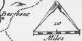
Each map has a scale line of:- 10 Miles chequered in miles, with a pair of dividers. The estimates below are for the facsimiles not the originals, and all wrongly assume a statute mile. Westmorland: 10 miles = 15.8 mm gives a scale 1 to 1018572. the map scale is about:- 1 to 1000000 16 miles to 1 inch Cumberland: 10 miles = 10.3 mm gives a scale 1 to 1562470. The map scale is about:- 1 to 1600000 25 miles to 1 inch Lancashire: 10 miles = 10.2 mm gives a scale 1 to 1577788. The map scale is about:- 1 to 1600000 25 miles to 1 inch |
|
|
|
||
| lat and long |
The latitude of the chief town in each county is
given:-
Kendal, Westmorland, 54d 24m W; Carlisle, Cumberland 55d 0m W; Lancaster, Lancashire 54d 10m W. There is no longitude data. The source of the information has not been discovered. |
|
|
|
||
|
sea area
sea plain |
The sea areas are plain.
|
|
|
|
||
|
coast line
coast shaded |
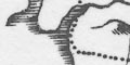
The coast line is shaded for emphasis. |
|
|
|
||
|
rivers
bridges |
Rivers are drawn by a wiggly line tapering upstream, the broader estuaries have the coast line shading. Rivers are mostly not labelled, but see in Lancashire:- Lunen fl Rible R Roads are but single lines so it is impossible to imply anything about bridges, whether a road interrupts a stream at their crossing. |
|
|
|
||
|
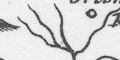
relief
hillocks |
On the westmorland map relief is suggested by hillocks shaded to the east. The hillocks are scattered in the western part of the county. |
|
|
|
||
| lakes |
Lakes are drawn by a crude outline, which might be
shaded. none are labelled, but the few shown can be
recognised (I think):-
Ullswater Windermere [shown as a broad river in Westmorland, as an outline in Lancashire] Derwent water Bassenthwaite Lake Coniston Water |
|
|
|
||
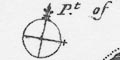
| county |
The county boundaries are a dotted line which might not be drawn alongside another feature which is the boundary. Adjacent counties are labelled, thus, on Westmorland:- Pt. of Cumberland Pt. of Lancas. Pt. of York Next to nothing is shown outwith the county, though Lancashire shows Kirkby Lonsdale and Kendal. |
|
|
|
||
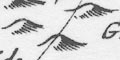
| settlements |
Settlements are marked by a circle with added elements;
differentiated a little by style of labelling. The maps are
small, few places are shown, not well chosen.
|
|
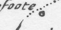
| cities |
circle, buildings, tower with cross; labelled =in upright
lowercase text, eg:-
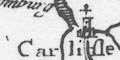
Carlisle Westmorland has no city. In Lancashire Lancaster in upright lowercase is marked as Carlisle but without the cross, not having a cathedral, thus not a city. |
|
|
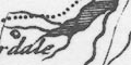
towns
villages hamlets |
circle; labelled in italic lowercase text, eg,
Westmorland:-
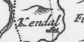
Kendal Howgill Firbank Pendragon The last being a castle without even a hamlet. Kendal has some buildings, marking it as the principal town? Two places in the county:- Brugh Hartley have a line and a ?flag on the circle. |
|
|
|
||
| roads |
As explained:- ... there is also the Road from London to each Citty or Towne, the great Roads are drawn with a double line, the other Roads a single line, ... These counties have a single line for the road from London to Carlisle shown on each map in turn:- from the south, through Lancaster, Lancashire; through Kendal, northward avoiding crossing the River Kent, across hills, by the head of Ullswater, Westmorland; then Penrith to Carlisle, Cumberland. and in Westmorland:- from Kendal, northwards close to the River Kent, to near Patterdale, Westmorland. The first is probably represents John Ogilby's route from London to Carlisle, the second is not an Ogilby route. Though rather small, these playing card maps are possibly the earliest roads maps of the counties. |
|
Lakes Guides menu.